Deck 20: Shorelines
ملء الشاشة (f)
سؤال
سؤال
سؤال
سؤال
سؤال
سؤال
سؤال
سؤال
سؤال
سؤال
سؤال
سؤال
سؤال
سؤال
سؤال
سؤال
سؤال
سؤال
سؤال
سؤال
سؤال
سؤال
سؤال
سؤال
سؤال
سؤال
سؤال
سؤال
سؤال
سؤال
سؤال
سؤال
سؤال
سؤال
سؤال
سؤال
سؤال
سؤال
سؤال
سؤال
سؤال
سؤال
سؤال
سؤال
سؤال
سؤال
سؤال
سؤال
سؤال
سؤال
سؤال
سؤال
سؤال
سؤال
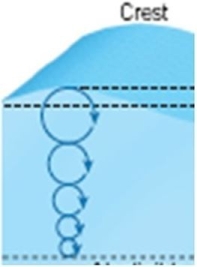 What kind of wave motion is visible in this image?
A)Circular orbital motion
B)Breaking wave
C)Rip current
D)Longshore current
سؤال
سؤال
 What kind of wave motion is visible in this image?
A)Circular orbital motion
B)Breaking wave
C)Rip current
D)Longshore current
سؤال
سؤال
سؤال
سؤال
سؤال
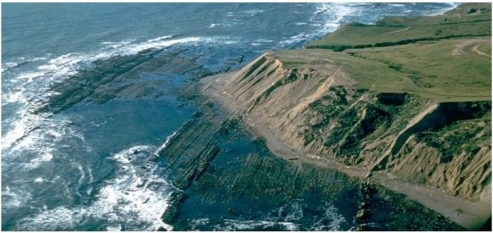
 What coastal erosion feature is visible in this image?
A)Sea stack
B)Estuary
C)Wave-cut platform
D)Sea arch
سؤال
 Which of the following scenarios could result in the exposure of the feature in this image?
A)Rising sea level floods this part of the shoreline.
B)Longshore currents deposit sand.
C)Rip currents remove beach deposits.
D)Tectonic activity raises the landscape.
سؤال
 In the previous question, you had to indicate where deposition and erosion were taking place in this image.Why would deposition or erosion occur at the areas you indicated?
A)Erosion occurs where there is low water velocity and deposition occurs where there is high water velocity.
B)Erosion results from circular orbital motion whereas deposition occurs from the waves feeling bottom.
C)Erosion occurs where the water is shallow and deposition occurs where the water is deep.
D)Erosion occurs where there is high water velocity and deposition occurs where there is low water velocity.
سؤال
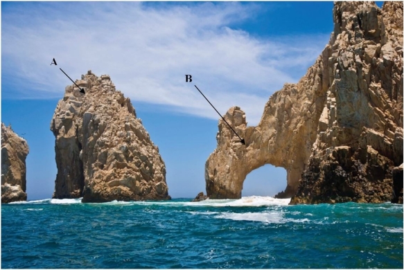 What erosional features, marked A and B, are visible in this figure?
A)Feature A is a headland and B is a sea cave.
B)Feature A is a spit and B is a Baymouth bar.
C)Feature A is a stack and B is a sea arch.
D)Feature A is a wave-cut bench and B is a spit.
سؤال
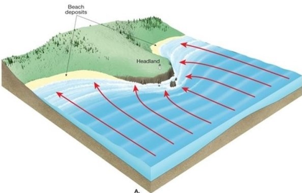
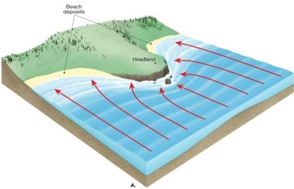 What process is illustrated by the arrows in this image?
A)Longshore current
B)Rip current
C)Wave refraction
D)Beach nourishment
سؤال
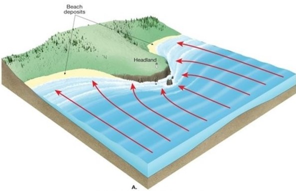 Which areas on this image will be dominated by deposition and which will be dominated by erosion?
A)Beaches will be dominated by erosion and the headland will be dominated by deposition.
B)Both the beaches and the headland will be dominated by deposition.
C)Beaches will be dominated by deposition and the headland will be dominated by erosion.
D)Both the beaches and the headland will be dominated by erosion.
سؤال
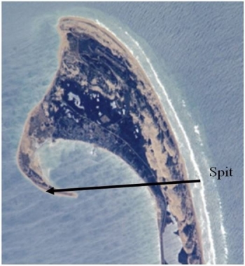 This image contains a spit, which is identified by an arrow.(The arrow is only for identification purposes.)Using the shape of the spit, from which direction is the longshore current coming? Assume for our purposes that the top of the figure is north.
A)From west to east
B)From north to south
C)From north to west
D)From south to east
سؤال
 This feature is evidence of a(n)________ coastline.
A)divergent
B)emergent
C)submergent
D)convergent
سؤال
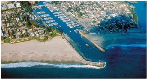 What coastal erosion stabilizers are visible in this image?
A)Headlands
B)Jetties
C)Breakwaters
D)Groins

فتح الحزمة
قم بالتسجيل لفتح البطاقات في هذه المجموعة!
Unlock Deck
Unlock Deck
1/69
العب
ملء الشاشة (f)
Deck 20: Shorelines
1
________ form when waves that approach the beach at an angle and produce a net current direction that is parallel to the shore, resulting in beach drift.
A)Refractions
B)Rip currents
C)Eddies
D)Longshore currents
A)Refractions
B)Rip currents
C)Eddies
D)Longshore currents
D
2
Circular orbital motion in waves will occur in ________ water.
A)still
B)deep
C)shallow
D)evaporating
A)still
B)deep
C)shallow
D)evaporating
B
3
When will a deepwater wave change to a shallow water wave as it approaches shore?
A)Wave period > twice the water depth
B)Wavelength = 1/2 water depth
C)Wavelength = 2 times water depth
D)Wave period > 1/2 water depth
A)Wave period > twice the water depth
B)Wavelength = 1/2 water depth
C)Wavelength = 2 times water depth
D)Wave period > 1/2 water depth
C
4
Abrasion will be greatest in which part of the beach environment?
A)Offshore Zone
B)Surf Zone
C)Backshore
D)Berms
A)Offshore Zone
B)Surf Zone
C)Backshore
D)Berms
فتح الحزمة
افتح القفل للوصول البطاقات البالغ عددها 69 في هذه المجموعة.
فتح الحزمة
k this deck
5
The ________ is the line that marks the contact between land and sea.
A)beach
B)shoreline
C)interface
D)foreshore
A)beach
B)shoreline
C)interface
D)foreshore
فتح الحزمة
افتح القفل للوصول البطاقات البالغ عددها 69 في هذه المجموعة.
فتح الحزمة
k this deck
6
What is a berm?
A)A flat-topped platform of sand adjacent to dunes or cliffs
B)Area landward of the high-tide shoreline
C)Wet, sloping surface of the beach
D)Build-up of sand where a stream meets the sea
A)A flat-topped platform of sand adjacent to dunes or cliffs
B)Area landward of the high-tide shoreline
C)Wet, sloping surface of the beach
D)Build-up of sand where a stream meets the sea
فتح الحزمة
افتح القفل للوصول البطاقات البالغ عددها 69 في هذه المجموعة.
فتح الحزمة
k this deck
7
Which of the following will not occur as the result of longshore currents?
A)Zigzag pattern of water movement
B)Transportation of sand
C)Refraction of waves
D)Periodic changes in the overall direction of flow parallel to the shore
A)Zigzag pattern of water movement
B)Transportation of sand
C)Refraction of waves
D)Periodic changes in the overall direction of flow parallel to the shore
فتح الحزمة
افتح القفل للوصول البطاقات البالغ عددها 69 في هذه المجموعة.
فتح الحزمة
k this deck
8
Defined by breaking waves in the surf zone, which two terms describe the directions of water movement associated with a wave breaking on the beach?
A)Fetch and swell
B)Emergence and submergence
C)Swash and backwash
D)Surf and beach
A)Fetch and swell
B)Emergence and submergence
C)Swash and backwash
D)Surf and beach
فتح الحزمة
افتح القفل للوصول البطاقات البالغ عددها 69 في هذه المجموعة.
فتح الحزمة
k this deck
9
As the quantity of energy transferred to the wave increases, what will happen to the height and the steepness of the wave?
A)Wave height increases and steepness decreases.
B)Wave height decreases and steepness increases.
C)Both the wave height and steepness decrease.
D)Both the wave height and steepness increase.
A)Wave height increases and steepness decreases.
B)Wave height decreases and steepness increases.
C)Both the wave height and steepness decrease.
D)Both the wave height and steepness increase.
فتح الحزمة
افتح القفل للوصول البطاقات البالغ عددها 69 في هذه المجموعة.
فتح الحزمة
k this deck
10
Which of the following locations has a coastline famous for its erosional features such as wave-cut platforms?
A)Northern California
B)Florida
C)North Carolina
D)Louisiana
A)Northern California
B)Florida
C)North Carolina
D)Louisiana
فتح الحزمة
افتح القفل للوصول البطاقات البالغ عددها 69 في هذه المجموعة.
فتح الحزمة
k this deck
11
If you happen to be caught in a rip current, what is the best way to get to safety?
A)Swim straight toward shore.
B)Swim parallel to the shore.
C)Swim further out to sea.
D)Tread water and do nothing.
A)Swim straight toward shore.
B)Swim parallel to the shore.
C)Swim further out to sea.
D)Tread water and do nothing.
فتح الحزمة
افتح القفل للوصول البطاقات البالغ عددها 69 في هذه المجموعة.
فتح الحزمة
k this deck
12
What term describes the bending of waves?
A)Reflection
B)Oscillation
C)Refraction
D)Frequency
A)Reflection
B)Oscillation
C)Refraction
D)Frequency
فتح الحزمة
افتح القفل للوصول البطاقات البالغ عددها 69 في هذه المجموعة.
فتح الحزمة
k this deck
13
Which circumstance will force a wave displaying circular orbital motion to slow down at the base, which allows the wave to break?
A)The water gets deeper.
B)The seafloor is uneven.
C)The wave is refracted.
D)The wave feels bottom with shallower depth.
A)The water gets deeper.
B)The seafloor is uneven.
C)The wave is refracted.
D)The wave feels bottom with shallower depth.
فتح الحزمة
افتح القفل للوصول البطاقات البالغ عددها 69 في هذه المجموعة.
فتح الحزمة
k this deck
14
What is the wave base?
A)Water depth equal to 1/2 the distance between successive waves
B)Maximum wave height based on wind velocity
C)The minimum elevation of a wave before it will start to curl
D)The distance up the shore where waves can erode
A)Water depth equal to 1/2 the distance between successive waves
B)Maximum wave height based on wind velocity
C)The minimum elevation of a wave before it will start to curl
D)The distance up the shore where waves can erode
فتح الحزمة
افتح القفل للوصول البطاقات البالغ عددها 69 في هذه المجموعة.
فتح الحزمة
k this deck
15
If the distance from one wave crest to the next is 10 ft., what will the depth to the wave base be?
A)2 ft.
B)5 ft.
C)11 ft.
D)20 ft.
A)2 ft.
B)5 ft.
C)11 ft.
D)20 ft.
فتح الحزمة
افتح القفل للوصول البطاقات البالغ عددها 69 في هذه المجموعة.
فتح الحزمة
k this deck
16
________ is a strong current formed by backwash concentrated into small channels and flows rapidly away from the beach.
A)Refraction
B)Rip currents
C)Eddies
D)Longshore currents
A)Refraction
B)Rip currents
C)Eddies
D)Longshore currents
فتح الحزمة
افتح القفل للوصول البطاقات البالغ عددها 69 في هذه المجموعة.
فتح الحزمة
k this deck
17
Which of the following scenarios is not related to wave refraction?
A)Waves approach the shore at an angle.
B)Sediment deposition will be concentrated in quiet areas such as bays and protected water.
C)Erosion is focused on the front and sides of headlands.
D)Large quantities of sand are carried from estuaries and deposited on the seacoast side of a barrier island system.
فتح الحزمة
افتح القفل للوصول البطاقات البالغ عددها 69 في هذه المجموعة.
فتح الحزمة
k this deck
18
Under which conditions will a wave be considered a deepwater wave?
A)Wavelength > 1/2 water depth
B)Wave height > water depth
C)Wavelength > 1/2 wave height
D)Water depth > 1/2 wavelength
A)Wavelength > 1/2 water depth
B)Wave height > water depth
C)Wavelength > 1/2 wave height
D)Water depth > 1/2 wavelength
فتح الحزمة
افتح القفل للوصول البطاقات البالغ عددها 69 في هذه المجموعة.
فتح الحزمة
k this deck
19
________ is the turbulent water created by breaking waves.
A)A swell
B)A refracted wave
C)A tombolo
D)Surf
A)A swell
B)A refracted wave
C)A tombolo
D)Surf
فتح الحزمة
افتح القفل للوصول البطاقات البالغ عددها 69 في هذه المجموعة.
فتح الحزمة
k this deck
20
What is the fetch?
A)Ocean currents that move in a direction parallel to the beach
B)The area of quiet water where deposition is taking place
C)A large area of open water over which wind blows to generate waves
D)Erosion of coastal cliffs creating wave-cut benches
A)Ocean currents that move in a direction parallel to the beach
B)The area of quiet water where deposition is taking place
C)A large area of open water over which wind blows to generate waves
D)Erosion of coastal cliffs creating wave-cut benches
فتح الحزمة
افتح القفل للوصول البطاقات البالغ عددها 69 في هذه المجموعة.
فتح الحزمة
k this deck
21
Which central part of a hurricane is characterized by a calm zone where precipitation and winds cease?
A)Typhoon
B)Eye wall
C)Pressure gradient
D)Eye
A)Typhoon
B)Eye wall
C)Pressure gradient
D)Eye
فتح الحزمة
افتح القفل للوصول البطاقات البالغ عددها 69 في هذه المجموعة.
فتح الحزمة
k this deck
22
What prevents hurricanes from developing in the band five degrees on either side of the Equator?
A)The Coriolis Effect is too weak.
B)Too much precipitation.
C)Temperatures are not high enough.
D)Lack of wind near the Equator.
A)The Coriolis Effect is too weak.
B)Too much precipitation.
C)Temperatures are not high enough.
D)Lack of wind near the Equator.
فتح الحزمة
افتح القفل للوصول البطاقات البالغ عددها 69 في هذه المجموعة.
فتح الحزمة
k this deck
23
Hurricanes get their energy from ________ water.
A)cold
B)warm
C)fresh
D)still
A)cold
B)warm
C)fresh
D)still
فتح الحزمة
افتح القفل للوصول البطاقات البالغ عددها 69 في هذه المجموعة.
فتح الحزمة
k this deck
24
A(n)________ coast will be created when sea level rises or the land subsides.
A)exposed
B)emergent
C)submergent
D)eroded
A)exposed
B)emergent
C)submergent
D)eroded
فتح الحزمة
افتح القفل للوصول البطاقات البالغ عددها 69 في هذه المجموعة.
فتح الحزمة
k this deck
25
The presence of a breakwater can promote several actions along a shoreline.However, which one of the following would not result because of the presence of a breakwater?
A)Storm waves breaking on the seaward side of the structure.
B)Increased beach erosion on either side of the breakwater.
C)Quiet water on the landward side of the breakwater, resulting in deposition.
D)Increase of rip currents and longshore currents because of interference from the structure.
A)Storm waves breaking on the seaward side of the structure.
B)Increased beach erosion on either side of the breakwater.
C)Quiet water on the landward side of the breakwater, resulting in deposition.
D)Increase of rip currents and longshore currents because of interference from the structure.
فتح الحزمة
افتح القفل للوصول البطاقات البالغ عددها 69 في هذه المجموعة.
فتح الحزمة
k this deck
26
Which of the following locations has a coastline famous for its depositional features such as barrier islands?
A)Northern California
B)Baja Peninsula, Mexico
C)Oregon
D)North Carolina
A)Northern California
B)Baja Peninsula, Mexico
C)Oregon
D)North Carolina
فتح الحزمة
افتح القفل للوصول البطاقات البالغ عددها 69 في هذه المجموعة.
فتح الحزمة
k this deck
27
Which of the following is an artificial coastal feature?
A)Baymouth bar
B)Jetty
C)Spit
D)Tombolo
A)Baymouth bar
B)Jetty
C)Spit
D)Tombolo
فتح الحزمة
افتح القفل للوصول البطاقات البالغ عددها 69 في هذه المجموعة.
فتح الحزمة
k this deck
28
Which beach stabilization technique requires dumping many truckloads of sand on a beach to build it up?
A)Beach nourishment
B)Relocation
C)Groins
D)Seawalls
A)Beach nourishment
B)Relocation
C)Groins
D)Seawalls
فتح الحزمة
افتح القفل للوصول البطاقات البالغ عددها 69 في هذه المجموعة.
فتح الحزمة
k this deck
29
During the last glaciation, a large tongue of glacial ice occupied Lake Michigan for thousands of years.How, several thousand years after the retreat of the ice, an emergent coastline is developing along part of the lake.What geologic process is creating an emergent coastline in Lake Michigan?
A)Lake levels are falling.
B)Rebound of a depressed crust.
C)Subsidence of the land surface around the lake.
D)Accumulation of dunes on the beach.
A)Lake levels are falling.
B)Rebound of a depressed crust.
C)Subsidence of the land surface around the lake.
D)Accumulation of dunes on the beach.
فتح الحزمة
افتح القفل للوصول البطاقات البالغ عددها 69 في هذه المجموعة.
فتح الحزمة
k this deck
30
What generates tides on the earth?
A)Gravitational repulsion of the sun
B)Melting of ice sheets
C)Gravitational attraction of the moon
D)Upwelling of methane gas
A)Gravitational repulsion of the sun
B)Melting of ice sheets
C)Gravitational attraction of the moon
D)Upwelling of methane gas
فتح الحزمة
افتح القفل للوصول البطاقات البالغ عددها 69 في هذه المجموعة.
فتح الحزمة
k this deck
31
What are the three categories of damage caused by hurricanes?
A)Eye, eye wall, and clouds
B)Wavelength, wave crest, and wave height
C)Storm surge, wind damage, and inland flooding
D)Shoreline erosion, flooding, and barometric pressure
A)Eye, eye wall, and clouds
B)Wavelength, wave crest, and wave height
C)Storm surge, wind damage, and inland flooding
D)Shoreline erosion, flooding, and barometric pressure
فتح الحزمة
افتح القفل للوصول البطاقات البالغ عددها 69 في هذه المجموعة.
فتح الحزمة
k this deck
32
Which of the following deposition/erosion scenarios will develop when a groin is constructed on the beach?
A)Erosion on upcurrent and downcurrent sides
B)Erosion on upcurrent side and deposition on downcurrent side
C)Deposition on upcurrent and downcurrent sides
D)Deposition on upcurrent side and erosion on downcurrent side
A)Erosion on upcurrent and downcurrent sides
B)Erosion on upcurrent side and deposition on downcurrent side
C)Deposition on upcurrent and downcurrent sides
D)Deposition on upcurrent side and erosion on downcurrent side
فتح الحزمة
افتح القفل للوصول البطاقات البالغ عددها 69 في هذه المجموعة.
فتح الحزمة
k this deck
33
The shoreline represents an interface between the land, sea, and air.
فتح الحزمة
افتح القفل للوصول البطاقات البالغ عددها 69 في هذه المجموعة.
فتح الحزمة
k this deck
34
How has sea level changed over the last few thousand years?
A)It has risen 1 cm per millennium.
B)It has remain constant.
C)It has fallen 25 cm per century.
D)It has risen about 10 cm per century.
A)It has risen 1 cm per millennium.
B)It has remain constant.
C)It has fallen 25 cm per century.
D)It has risen about 10 cm per century.
فتح الحزمة
افتح القفل للوصول البطاقات البالغ عددها 69 في هذه المجموعة.
فتح الحزمة
k this deck
35
A ________ is a hard shoreline stabilization feature, detached from the shoreline, that protects shorelines from the pounding of waves by creating an area of quiet water behind it.
A)groin
B)seawall
C)breakwater
D)jetty
A)groin
B)seawall
C)breakwater
D)jetty
فتح الحزمة
افتح القفل للوصول البطاقات البالغ عددها 69 في هذه المجموعة.
فتح الحزمة
k this deck
36
What system of measurement is used to categorize the strength of a hurricane?
A)Richter Scale
B)Mercalli Scale
C)Fujita Scale
D)Saffir-Simpson Scale
A)Richter Scale
B)Mercalli Scale
C)Fujita Scale
D)Saffir-Simpson Scale
فتح الحزمة
افتح القفل للوصول البطاقات البالغ عددها 69 في هذه المجموعة.
فتح الحزمة
k this deck
37
Which of the following coastal features is not a characteristic of a submergent coastline?
A)Barrier islands
B)Estuaries
C)Wave-cut platform
D)Irregular coastlines
A)Barrier islands
B)Estuaries
C)Wave-cut platform
D)Irregular coastlines
فتح الحزمة
افتح القفل للوصول البطاقات البالغ عددها 69 في هذه المجموعة.
فتح الحزمة
k this deck
38
The erosional retreat of a coastal cliff will lead to the enlargement of a ________.
A)wave-cut arch
B)wave-cut beach
C)wave-cut stack
D)wave-cut platform
A)wave-cut arch
B)wave-cut beach
C)wave-cut stack
D)wave-cut platform
فتح الحزمة
افتح القفل للوصول البطاقات البالغ عددها 69 في هذه المجموعة.
فتح الحزمة
k this deck
39
A(n)________ coast will be created when sea level falls or the land is uplifted.
A)exposed
B)emergent
C)submergent
D)eroded
A)exposed
B)emergent
C)submergent
D)eroded
فتح الحزمة
افتح القفل للوصول البطاقات البالغ عددها 69 في هذه المجموعة.
فتح الحزمة
k this deck
40
Which of the following areas consists of narrow beaches backed by steep cliffs and mountain ranges?
A)Pacific Coast
B)Atlantic Coast
C)Gulf Coast
D)Florida shoreline
A)Pacific Coast
B)Atlantic Coast
C)Gulf Coast
D)Florida shoreline
فتح الحزمة
افتح القفل للوصول البطاقات البالغ عددها 69 في هذه المجموعة.
فتح الحزمة
k this deck
41
Explain why waves will begin to curl and fall over as they approach shore.
فتح الحزمة
افتح القفل للوصول البطاقات البالغ عددها 69 في هذه المجموعة.
فتح الحزمة
k this deck
42
Rip currents are the result of tidal variations.
فتح الحزمة
افتح القفل للوصول البطاقات البالغ عددها 69 في هذه المجموعة.
فتح الحزمة
k this deck
43
Most hurricanes form poleward of 20° latitude.
فتح الحزمة
افتح القفل للوصول البطاقات البالغ عددها 69 في هذه المجموعة.
فتح الحزمة
k this deck
44
What are three ways barrier islands can form?
فتح الحزمة
افتح القفل للوصول البطاقات البالغ عددها 69 في هذه المجموعة.
فتح الحزمة
k this deck
45
Beaches are locations along the shoreline where excess sediment has accumulated on shore.
فتح الحزمة
افتح القفل للوصول البطاقات البالغ عددها 69 في هذه المجموعة.
فتح الحزمة
k this deck
46
A large wave generated by an earthquake off the coast of Chile can travel across the Pacific Ocean to reach the shores of Alaska.
فتح الحزمة
افتح القفل للوصول البطاقات البالغ عددها 69 في هذه المجموعة.
فتح الحزمة
k this deck
47
How does the rotation of the earth give coastlines a high tide and a low tide?
فتح الحزمة
افتح القفل للوصول البطاقات البالغ عددها 69 في هذه المجموعة.
فتح الحزمة
k this deck
48
Barrier islands are more common along the Atlantic Coast than the Pacific Coast.
فتح الحزمة
افتح القفل للوصول البطاقات البالغ عددها 69 في هذه المجموعة.
فتح الحزمة
k this deck
49
Due to the crashing of waves and the backwash of water from shore, beaches can be thought of as areas where material is in transit.
فتح الحزمة
افتح القفل للوصول البطاقات البالغ عددها 69 في هذه المجموعة.
فتح الحزمة
k this deck
50
Coastal areas undergo some of the most rapid and dynamic change due to their constant contact with the water.
فتح الحزمة
افتح القفل للوصول البطاقات البالغ عددها 69 في هذه المجموعة.
فتح الحزمة
k this deck
51
If a shoreline remains stable over time, an irregular coast will be transformed into a smoother, straighter coast.
فتح الحزمة
افتح القفل للوصول البطاقات البالغ عددها 69 في هذه المجموعة.
فتح الحزمة
k this deck
52
How would coastline composition (rocky versus sandy)differ from the coastline of the Pacific Northwest and that of the Carolinas?
فتح الحزمة
افتح القفل للوصول البطاقات البالغ عددها 69 في هذه المجموعة.
فتح الحزمة
k this deck
53
Rivers in the Pacific Northwest are heavily managed by the construction of dams and reservoirs in order to produce hydroelectric power and, in some areas, for irrigation.However, the construction of interior dams can have serious consequences for the coastal erosion of beaches and rocky bluffs along the Pacific Coast.How can the construction of these dams lead to the erosion of a rocky coastal bluff?
فتح الحزمة
افتح القفل للوصول البطاقات البالغ عددها 69 في هذه المجموعة.
فتح الحزمة
k this deck
54
What kind of wave motion is visible in this image?A)Circular orbital motion
B)Breaking wave
C)Rip current
D)Longshore current
فتح الحزمة
افتح القفل للوصول البطاقات البالغ عددها 69 في هذه المجموعة.
فتح الحزمة
k this deck
55
Hard stabilization methods of protecting beaches from erosion are ultimately only a form of temporary protection.
فتح الحزمة
افتح القفل للوصول البطاقات البالغ عددها 69 في هذه المجموعة.
فتح الحزمة
k this deck
56
What kind of wave motion is visible in this image?A)Circular orbital motion
B)Breaking wave
C)Rip current
D)Longshore current
فتح الحزمة
افتح القفل للوصول البطاقات البالغ عددها 69 في هذه المجموعة.
فتح الحزمة
k this deck
57
Explain how the construction of a hard stabilization feature (i.e., groin)will force the deposition of sediment on a coastline.
فتح الحزمة
افتح القفل للوصول البطاقات البالغ عددها 69 في هذه المجموعة.
فتح الحزمة
k this deck
58
Black sand beaches in Hawaii were created by the erosion and deposition of coral.
فتح الحزمة
افتح القفل للوصول البطاقات البالغ عددها 69 في هذه المجموعة.
فتح الحزمة
k this deck
59
What is the difference between the eye and eye wall of a hurricane?
فتح الحزمة
افتح القفل للوصول البطاقات البالغ عددها 69 في هذه المجموعة.
فتح الحزمة
k this deck
60
What combination of incoming waves and backwash will result in a longshore drift? Explain.
فتح الحزمة
افتح القفل للوصول البطاقات البالغ عددها 69 في هذه المجموعة.
فتح الحزمة
k this deck
61
What coastal erosion feature is visible in this image?A)Sea stack
B)Estuary
C)Wave-cut platform
D)Sea arch
فتح الحزمة
افتح القفل للوصول البطاقات البالغ عددها 69 في هذه المجموعة.
فتح الحزمة
k this deck
62
Which of the following scenarios could result in the exposure of the feature in this image?A)Rising sea level floods this part of the shoreline.
B)Longshore currents deposit sand.
C)Rip currents remove beach deposits.
D)Tectonic activity raises the landscape.
فتح الحزمة
افتح القفل للوصول البطاقات البالغ عددها 69 في هذه المجموعة.
فتح الحزمة
k this deck
63
In the previous question, you had to indicate where deposition and erosion were taking place in this image.Why would deposition or erosion occur at the areas you indicated?A)Erosion occurs where there is low water velocity and deposition occurs where there is high water velocity.
B)Erosion results from circular orbital motion whereas deposition occurs from the waves feeling bottom.
C)Erosion occurs where the water is shallow and deposition occurs where the water is deep.
D)Erosion occurs where there is high water velocity and deposition occurs where there is low water velocity.
فتح الحزمة
افتح القفل للوصول البطاقات البالغ عددها 69 في هذه المجموعة.
فتح الحزمة
k this deck
64
What erosional features, marked A and B, are visible in this figure?A)Feature A is a headland and B is a sea cave.
B)Feature A is a spit and B is a Baymouth bar.
C)Feature A is a stack and B is a sea arch.
D)Feature A is a wave-cut bench and B is a spit.
فتح الحزمة
افتح القفل للوصول البطاقات البالغ عددها 69 في هذه المجموعة.
فتح الحزمة
k this deck
65
What process is illustrated by the arrows in this image?A)Longshore current
B)Rip current
C)Wave refraction
D)Beach nourishment
فتح الحزمة
افتح القفل للوصول البطاقات البالغ عددها 69 في هذه المجموعة.
فتح الحزمة
k this deck
66
Which areas on this image will be dominated by deposition and which will be dominated by erosion?A)Beaches will be dominated by erosion and the headland will be dominated by deposition.
B)Both the beaches and the headland will be dominated by deposition.
C)Beaches will be dominated by deposition and the headland will be dominated by erosion.
D)Both the beaches and the headland will be dominated by erosion.
فتح الحزمة
افتح القفل للوصول البطاقات البالغ عددها 69 في هذه المجموعة.
فتح الحزمة
k this deck
67
This image contains a spit, which is identified by an arrow.(The arrow is only for identification purposes.)Using the shape of the spit, from which direction is the longshore current coming? Assume for our purposes that the top of the figure is north.A)From west to east
B)From north to south
C)From north to west
D)From south to east
فتح الحزمة
افتح القفل للوصول البطاقات البالغ عددها 69 في هذه المجموعة.
فتح الحزمة
k this deck
68
This feature is evidence of a(n)________ coastline.A)divergent
B)emergent
C)submergent
D)convergent
فتح الحزمة
افتح القفل للوصول البطاقات البالغ عددها 69 في هذه المجموعة.
فتح الحزمة
k this deck
69
What coastal erosion stabilizers are visible in this image?A)Headlands
B)Jetties
C)Breakwaters
D)Groins
فتح الحزمة
افتح القفل للوصول البطاقات البالغ عددها 69 في هذه المجموعة.
فتح الحزمة
k this deck
فتح الحزمة
افتح القفل للوصول البطاقات البالغ عددها 69 في هذه المجموعة.


