Deck 19: Water, Wind, and Time: Desert Landforms
ملء الشاشة (f)
سؤال
سؤال
سؤال
سؤال
سؤال
سؤال
سؤال
سؤال
سؤال
سؤال
سؤال
سؤال
سؤال
سؤال
سؤال
سؤال
سؤال
سؤال
سؤال
سؤال
سؤال
سؤال
سؤال
سؤال
سؤال
سؤال
سؤال
سؤال
سؤال
سؤال
سؤال
سؤال
سؤال
سؤال
سؤال
سؤال
سؤال
سؤال
سؤال
سؤال
سؤال
سؤال
سؤال
سؤال
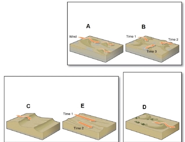
In the figure, barchan dunes are shown in which box?
A)A
B)B
C)C
D)D
سؤال
سؤال
سؤال
سؤال
سؤال
سؤال
سؤال
سؤال
سؤال
سؤال
سؤال
سؤال
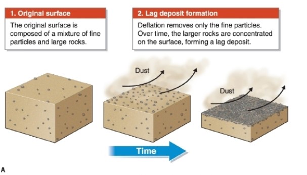
In the figure, a lag deposit develops through what process?
A)weathering
B)exfoliation
C)deflation
D)mass wasting
سؤال
سؤال
سؤال
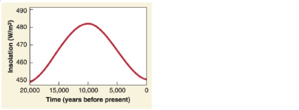
"Summer insolation" was highest how many years ago, according to this graph?
A)5,000
B)10,000
C)15,000
D)20,000
سؤال
سؤال
سؤال
سؤال
سؤال
سؤال
سؤال
سؤال
سؤال
سؤال
سؤال
سؤال
سؤال
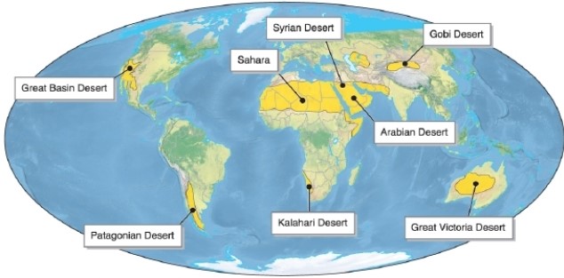
Referring to the figure, which desert is a rain shadow desert?
A)Gobi Desert
B)Great Victoria Desert
C)Patagonian Desert
D)the Sahara
سؤال
سؤال
سؤال
سؤال
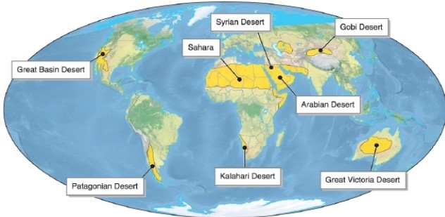
Referring to the figure, which desert is the largest?
A)Syrian Desert
B)Arabian Desert
C)Kalahari Desert
D)the Sahara
سؤال
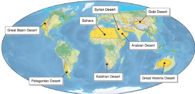
Referring to the figure, which desert is in South America?
A)Gobi Desert
B)Great Victoria Desert
C)Patagonian Desert
D)the Sahara
سؤال
سؤال
سؤال

فتح الحزمة
قم بالتسجيل لفتح البطاقات في هذه المجموعة!
Unlock Deck
Unlock Deck
1/135
العب
ملء الشاشة (f)
Deck 19: Water, Wind, and Time: Desert Landforms
1
Owens Lake disappeared because of natural drought cycles.
False
2
In the Basin-and-Range in the Great Basin, horsts are mountain ranges and grabens are valleys.
True
3
By volume, desert lakes are among the largest lakes in the world.
False
4
Badlands are "bad" because they have naturally toxic soils.
فتح الحزمة
افتح القفل للوصول البطاقات البالغ عددها 135 في هذه المجموعة.
فتح الحزمة
k this deck
5
Antofagasta is located in the driest desert in the world but still experiences occasional flooding.
فتح الحزمة
افتح القفل للوصول البطاقات البالغ عددها 135 في هذه المجموعة.
فتح الحزمة
k this deck
6
Chemical weathering is more important than physical weathering in deserts.
فتح الحزمة
افتح القفل للوصول البطاقات البالغ عددها 135 في هذه المجموعة.
فتح الحزمة
k this deck
7
The Green Sahara refers to a period when the Sahara Desert was covered with tropical rainforests.
فتح الحزمة
افتح القفل للوصول البطاقات البالغ عددها 135 في هذه المجموعة.
فتح الحزمة
k this deck
8
Antofagasta is located in the rain shadow of the Andes.
فتح الحزمة
افتح القفل للوصول البطاقات البالغ عددها 135 في هذه المجموعة.
فتح الحزمة
k this deck
9
Some sand dunes make an audible sound or "sing" as their particles move in the wind.
فتح الحزمة
افتح القفل للوصول البطاقات البالغ عددها 135 في هذه المجموعة.
فتح الحزمة
k this deck
10
The Basin-and-Range is an example of a geographic province.
فتح الحزمة
افتح القفل للوصول البطاقات البالغ عددها 135 في هذه المجموعة.
فتح الحزمة
k this deck
11
Desertification is both natural and anthropogenic conversion of arid lands to desert.
فتح الحزمة
افتح القفل للوصول البطاقات البالغ عددها 135 في هذه المجموعة.
فتح الحزمة
k this deck
12
A lag deposit forms as small particles such as sand and clay are carried away by the wind, leaving an accumulation of rocks.
فتح الحزمة
افتح القفل للوصول البطاقات البالغ عددها 135 في هذه المجموعة.
فتح الحزمة
k this deck
13
All badlands are caused by poor landscape practices by people.
فتح الحزمة
افتح القفل للوصول البطاقات البالغ عددها 135 في هذه المجموعة.
فتح الحزمة
k this deck
14
Dust storms in Owens Lake contain chromium, cadmium, and arsenic.
فتح الحزمة
افتح القفل للوصول البطاقات البالغ عددها 135 في هذه المجموعة.
فتح الحزمة
k this deck
15
Sand for ergs often comes from former glacial outwash plains, dry lake beds, and river deltas.
فتح الحزمة
افتح القفل للوصول البطاقات البالغ عددها 135 في هذه المجموعة.
فتح الحزمة
k this deck
16
In recent years Mono Lake's water level has been rising because of improved management of its water resources.
فتح الحزمة
افتح القفل للوصول البطاقات البالغ عددها 135 في هذه المجموعة.
فتح الحزمة
k this deck
17
The Amu Darya and the Syr Darya rivers once flowed into the Aral Sea.
فتح الحزمة
افتح القفل للوصول البطاقات البالغ عددها 135 في هذه المجموعة.
فتح الحزمة
k this deck
18
Mesa-and-butte terrain forms only in sedimentary rocks.
فتح الحزمة
افتح القفل للوصول البطاقات البالغ عددها 135 في هذه المجموعة.
فتح الحزمة
k this deck
19
In part, Antofagasta is arid because of the cold Peru ocean current.
فتح الحزمة
افتح القفل للوصول البطاقات البالغ عددها 135 في هذه المجموعة.
فتح الحزمة
k this deck
20
As Mono Lake's level dropped, submerged tufa formations became exposed.
فتح الحزمة
افتح القفل للوصول البطاقات البالغ عددها 135 في هذه المجموعة.
فتح الحزمة
k this deck
21
A petroglyph is a prehistoric rock carving.
فتح الحزمة
افتح القفل للوصول البطاقات البالغ عددها 135 في هذه المجموعة.
فتح الحزمة
k this deck
22
Eolian erosion is the most important agent of erosion in deserts.
فتح الحزمة
افتح القفل للوصول البطاقات البالغ عددها 135 في هذه المجموعة.
فتح الحزمة
k this deck
23
The presence of an inselberg indicates that net erosion is occurring.
فتح الحزمة
افتح القفل للوصول البطاقات البالغ عددها 135 في هذه المجموعة.
فتح الحزمة
k this deck
24
Inselbergs are found in all climates, not just deserts.
فتح الحزمة
افتح القفل للوصول البطاقات البالغ عددها 135 في هذه المجموعة.
فتح الحزمة
k this deck
25
Sand dunes are found only in deserts.
فتح الحزمة
افتح القفل للوصول البطاقات البالغ عددها 135 في هذه المجموعة.
فتح الحزمة
k this deck
26
There were more permanent human settlements in the central Sahara about 5,000 years ago than there are today.
فتح الحزمة
افتح القفل للوصول البطاقات البالغ عددها 135 في هذه المجموعة.
فتح الحزمة
k this deck
27
The Green Sahara refers to a period when large lakes existed in what is now the Sahara Desert.
فتح الحزمة
افتح القفل للوصول البطاقات البالغ عددها 135 في هذه المجموعة.
فتح الحزمة
k this deck
28
Sand dunes migrate in the direction that the prevailing wind blows.
فتح الحزمة
افتح القفل للوصول البطاقات البالغ عددها 135 في هذه المجموعة.
فتح الحزمة
k this deck
29
Eolian erosion and deposition sorts particles by their sizes.
فتح الحزمة
افتح القفل للوصول البطاقات البالغ عددها 135 في هذه المجموعة.
فتح الحزمة
k this deck
30
Eolian means "of or relating to wind."
فتح الحزمة
افتح القفل للوصول البطاقات البالغ عددها 135 في هذه المجموعة.
فتح الحزمة
k this deck
31
Mesa-and-butte terrain occurs only in deserts.
فتح الحزمة
افتح القفل للوصول البطاقات البالغ عددها 135 في هذه المجموعة.
فتح الحزمة
k this deck
32
Fossils are common in badlands.
فتح الحزمة
افتح القفل للوصول البطاقات البالغ عددها 135 في هذه المجموعة.
فتح الحزمة
k this deck
33
Dust in Owens Valley today is about 30% salt.
فتح الحزمة
افتح القفل للوصول البطاقات البالغ عددها 135 في هذه المجموعة.
فتح الحزمة
k this deck
34
A bornhardt is an inselberg that is derived from crystalline rocks like granite or gneiss.
فتح الحزمة
افتح القفل للوصول البطاقات البالغ عددها 135 في هذه المجموعة.
فتح الحزمة
k this deck
35
Desert pavement is formed by the erosion of windblown silt and clay.
فتح الحزمة
افتح القفل للوصول البطاقات البالغ عددها 135 في هذه المجموعة.
فتح الحزمة
k this deck
36
Rock varnish is formed by the activities of bacteria.
فتح الحزمة
افتح القفل للوصول البطاقات البالغ عددها 135 في هذه المجموعة.
فتح الحزمة
k this deck
37
In the Great Basin Desert, grabens are a form of inselberg.
فتح الحزمة
افتح القفل للوصول البطاقات البالغ عددها 135 في هذه المجموعة.
فتح الحزمة
k this deck
38
Antofagasta is dry due to the influence of the subpolar low.
فتح الحزمة
افتح القفل للوصول البطاقات البالغ عددها 135 في هذه المجموعة.
فتح الحزمة
k this deck
39
Mono Lake's water level has dropped due to water diversions.
فتح الحزمة
افتح القفل للوصول البطاقات البالغ عددها 135 في هذه المجموعة.
فتح الحزمة
k this deck
40
Most deserts receive less than 25 cm (10 in) of precipitation annually.
فتح الحزمة
افتح القفل للوصول البطاقات البالغ عددها 135 في هذه المجموعة.
فتح الحزمة
k this deck
41
When did water diversions from Owens Lake begin?
A)1900
B)1913
C)1926
D)1953
A)1900
B)1913
C)1926
D)1953
فتح الحزمة
افتح القفل للوصول البطاقات البالغ عددها 135 في هذه المجموعة.
فتح الحزمة
k this deck
42
The process of removing sediments and lowering the land surface by wind erosion is called what?
A)a blowout depression
B)desertification
C)deflation
D)desert pavement
A)a blowout depression
B)desertification
C)deflation
D)desert pavement
فتح الحزمة
افتح القفل للوصول البطاقات البالغ عددها 135 في هذه المجموعة.
فتح الحزمة
k this deck
43
Through saltation and traction, sand grains move up the ___________ of active sand dunes.
A)bedding planes
B)windward side
C)leeward side
D)slip face
A)bedding planes
B)windward side
C)leeward side
D)slip face
فتح الحزمة
افتح القفل للوصول البطاقات البالغ عددها 135 في هذه المجموعة.
فتح الحزمة
k this deck
44
In the figure, barchan dunes are shown in which box?
A)A
B)B
C)C
D)D
فتح الحزمة
افتح القفل للوصول البطاقات البالغ عددها 135 في هذه المجموعة.
فتح الحزمة
k this deck
45
Why are dust storms toxic in the Aral Sea area today?
A)because the dust is naturally toxic
B)because the area is downwind of other polluted areas
C)because of agricultural chemicals
D)because of heavy industrial polluters in the area
A)because the dust is naturally toxic
B)because the area is downwind of other polluted areas
C)because of agricultural chemicals
D)because of heavy industrial polluters in the area
فتح الحزمة
افتح القفل للوصول البطاقات البالغ عددها 135 في هذه المجموعة.
فتح الحزمة
k this deck
46
A __________ is a flat-topped area that is wider than it is tall.
A)mesa
B)butte
C)chimney
D)mesa-and-butte terrain
A)mesa
B)butte
C)chimney
D)mesa-and-butte terrain
فتح الحزمة
افتح القفل للوصول البطاقات البالغ عددها 135 في هذه المجموعة.
فتح الحزمة
k this deck
47
What are dry stream channels called in India?
A)wadis
B)nullahs
C)dongas
D)arroyos
A)wadis
B)nullahs
C)dongas
D)arroyos
فتح الحزمة
افتح القفل للوصول البطاقات البالغ عددها 135 في هذه المجموعة.
فتح الحزمة
k this deck
48
Erosion of sandstone creates what?
A)rock varnish
B)quartz sand
C)ventifacts
D)a pedestal rock
A)rock varnish
B)quartz sand
C)ventifacts
D)a pedestal rock
فتح الحزمة
افتح القفل للوصول البطاقات البالغ عددها 135 في هذه المجموعة.
فتح الحزمة
k this deck
49
Where sand completely covers the desert floor, what linear dunes oriented perpendicularly to the prevailing wind direction may form?
A)transverse dunes
B)star dunes
C)barchan dunes
D)longitudinal dunes
A)transverse dunes
B)star dunes
C)barchan dunes
D)longitudinal dunes
فتح الحزمة
افتح القفل للوصول البطاقات البالغ عددها 135 في هذه المجموعة.
فتح الحزمة
k this deck
50
Approximately when did the Sahara experience wetter conditions?
A)20,000 years ago
B)15,000 years ago
C)7,000 years ago
D)1,000 year ago
A)20,000 years ago
B)15,000 years ago
C)7,000 years ago
D)1,000 year ago
فتح الحزمة
افتح القفل للوصول البطاقات البالغ عددها 135 في هذه المجموعة.
فتح الحزمة
k this deck
51
The Aral Sea streams were diverted mainly to grow what crop?
A)tomatoes
B)corn
C)cotton
D)wheat
A)tomatoes
B)corn
C)cotton
D)wheat
فتح الحزمة
افتح القفل للوصول البطاقات البالغ عددها 135 في هذه المجموعة.
فتح الحزمة
k this deck
52
In deserts, where streams exit a steep canyon a(n) __________ often forms.
A)alluvial fan
B)wadi
C)playa
D)yardang
A)alluvial fan
B)wadi
C)playa
D)yardang
فتح الحزمة
افتح القفل للوصول البطاقات البالغ عددها 135 في هذه المجموعة.
فتح الحزمة
k this deck
53
__________ consists of tightly interlocking stones that form a hardened surface on the desert floor.
A)A bajada
B)Desert pavement
C)An inselberg
D)A lag deposit
A)A bajada
B)Desert pavement
C)An inselberg
D)A lag deposit
فتح الحزمة
افتح القفل للوصول البطاقات البالغ عددها 135 في هذه المجموعة.
فتح الحزمة
k this deck
54
What city diverts water from Mono Lake?
A)Los Angeles
B)Phoenix
C)San Diego
D)Las Vegas
A)Los Angeles
B)Phoenix
C)San Diego
D)Las Vegas
فتح الحزمة
افتح القفل للوصول البطاقات البالغ عددها 135 في هذه المجموعة.
فتح الحزمة
k this deck
55
A flat, stony plain is called a(n) __________.
A)reg
B)mesa-and-butte terrain
C)inselberg
D)erg
A)reg
B)mesa-and-butte terrain
C)inselberg
D)erg
فتح الحزمة
افتح القفل للوصول البطاقات البالغ عددها 135 في هذه المجموعة.
فتح الحزمة
k this deck
56
In the figure, a lag deposit develops through what process?
A)weathering
B)exfoliation
C)deflation
D)mass wasting
فتح الحزمة
افتح القفل للوصول البطاقات البالغ عددها 135 في هذه المجموعة.
فتح الحزمة
k this deck
57
The largest erg is what?
A)the Rub' al Khali erg on the Arabian Peninsula
B)the Grand Erg Oriental in Algeria
C)the Erg Iquidi in Algeria
D)the Great Sand Sea in Libya and Egypt
A)the Rub' al Khali erg on the Arabian Peninsula
B)the Grand Erg Oriental in Algeria
C)the Erg Iquidi in Algeria
D)the Great Sand Sea in Libya and Egypt
فتح الحزمة
افتح القفل للوصول البطاقات البالغ عددها 135 في هذه المجموعة.
فتح الحزمة
k this deck
58
Which provides the correct sequence of mesa-and-butte terrain formation?
A)tectonic uplift-sedimentation and lithification-headward erosion
B)headward erosion-sedimentation and lithification-tectonic uplift
C)sedimentation and lithification-tectonic uplift-headward erosion
D)sedimentation and lithification-headward erosion-tectonic uplift
A)tectonic uplift-sedimentation and lithification-headward erosion
B)headward erosion-sedimentation and lithification-tectonic uplift
C)sedimentation and lithification-tectonic uplift-headward erosion
D)sedimentation and lithification-headward erosion-tectonic uplift
فتح الحزمة
افتح القفل للوصول البطاقات البالغ عددها 135 في هذه المجموعة.
فتح الحزمة
k this deck
59
"Summer insolation" was highest how many years ago, according to this graph?
A)5,000
B)10,000
C)15,000
D)20,000
فتح الحزمة
افتح القفل للوصول البطاقات البالغ عددها 135 في هذه المجموعة.
فتح الحزمة
k this deck
60
As a whole, sand dunes migrate in the direction of the ____________.
A)prevailing wind
B)angle of repose
C)windward side
D)dune crest
A)prevailing wind
B)angle of repose
C)windward side
D)dune crest
فتح الحزمة
افتح القفل للوصول البطاقات البالغ عددها 135 في هذه المجموعة.
فتح الحزمة
k this deck
61
A __________ is a slender spire of rock with a flat top.
A)mesa
B)butte
C)chimney
D)mesa-and-butte terrain
A)mesa
B)butte
C)chimney
D)mesa-and-butte terrain
فتح الحزمة
افتح القفل للوصول البطاقات البالغ عددها 135 في هذه المجموعة.
فتح الحزمة
k this deck
62
Ergs are by definition at least _______ square kilometers in extent.
A)50
B)100
C)125
D)200
A)50
B)100
C)125
D)200
فتح الحزمة
افتح القفل للوصول البطاقات البالغ عددها 135 في هذه المجموعة.
فتح الحزمة
k this deck
63
What scientific evidence is there that indicates the Sahara was wetter?
A)tree ring data
B)ancient beaches and fossils
C)ice core data
D)migration patterns of birds
A)tree ring data
B)ancient beaches and fossils
C)ice core data
D)migration patterns of birds
فتح الحزمة
افتح القفل للوصول البطاقات البالغ عددها 135 في هذه المجموعة.
فتح الحزمة
k this deck
64
Sand grains move over the crest and down the _____________ on active sand dunes.
A)bedding planes
B)windward side
C)direction of dune migration
D)slip face
A)bedding planes
B)windward side
C)direction of dune migration
D)slip face
فتح الحزمة
افتح القفل للوصول البطاقات البالغ عددها 135 في هذه المجموعة.
فتح الحزمة
k this deck
65
The Basin-and-Range Province in Nevada is forming because the crust is doing what?
A)lifting up
B)compressing
C)stretching
D)thickening
A)lifting up
B)compressing
C)stretching
D)thickening
فتح الحزمة
افتح القفل للوصول البطاقات البالغ عددها 135 في هذه المجموعة.
فتح الحزمة
k this deck
66
When the dip of sedimentary rocks is less than 30 degrees, a(n) __________ forms.
A)mesa
B)cuesta
C)hogback
D)inselberg
A)mesa
B)cuesta
C)hogback
D)inselberg
فتح الحزمة
افتح القفل للوصول البطاقات البالغ عددها 135 في هذه المجموعة.
فتح الحزمة
k this deck
67
Which is not true about the windward side of a sand dune?
A)Sand grains move up the windward side through traction.
B)Sand grains move up the windward side through saltation.
C)Sand ripples often form on the windward side.
D)The windward side settles at the angle of repose.
A)Sand grains move up the windward side through traction.
B)Sand grains move up the windward side through saltation.
C)Sand ripples often form on the windward side.
D)The windward side settles at the angle of repose.
فتح الحزمة
افتح القفل للوصول البطاقات البالغ عددها 135 في هذه المجموعة.
فتح الحزمة
k this deck
68
A(n) __________ is a large, weathered outcrop of bedrock surrounded by a flat, alluvium-filled plain.
A)mesa
B)cuesta
C)hogback
D)inselberg
A)mesa
B)cuesta
C)hogback
D)inselberg
فتح الحزمة
افتح القفل للوصول البطاقات البالغ عددها 135 في هذه المجموعة.
فتح الحزمة
k this deck
69
Why does the Aral Sea area now experience so many dust storms?
A)because the lake bed is exposed
B)because the wind speed has increased
C)because people have removed vegetation in the region that once anchored the soils
D)because farming activity has increased
A)because the lake bed is exposed
B)because the wind speed has increased
C)because people have removed vegetation in the region that once anchored the soils
D)because farming activity has increased
فتح الحزمة
افتح القفل للوصول البطاقات البالغ عددها 135 في هذه المجموعة.
فتح الحزمة
k this deck
70
Since 1994, what has been happening to Mono Lake?
A)Its lake level has continued to fall.
B)Its lake level has remained mostly stable.
C)Its lake level has risen dramatically.
D)It has become saltier.
A)Its lake level has continued to fall.
B)Its lake level has remained mostly stable.
C)Its lake level has risen dramatically.
D)It has become saltier.
فتح الحزمة
افتح القفل للوصول البطاقات البالغ عددها 135 في هذه المجموعة.
فتح الحزمة
k this deck
71
By what year was Owens Lake gone as a result of diversions?
A)1900
B)1913
C)1926
D)1953
A)1900
B)1913
C)1926
D)1953
فتح الحزمة
افتح القفل للوصول البطاقات البالغ عددها 135 في هذه المجموعة.
فتح الحزمة
k this deck
72
Referring to the figure, which desert is a rain shadow desert?
A)Gobi Desert
B)Great Victoria Desert
C)Patagonian Desert
D)the Sahara
فتح الحزمة
افتح القفل للوصول البطاقات البالغ عددها 135 في هذه المجموعة.
فتح الحزمة
k this deck
73
Where sand does not completely cover the desert floor and the prevailing wind consistently comes from one direction, what crescent-shaped dunes can form?
A)barchan dunes
B)star dunes
C)transverse dunes
D)parabolic dunes
A)barchan dunes
B)star dunes
C)transverse dunes
D)parabolic dunes
فتح الحزمة
افتح القفل للوصول البطاقات البالغ عددها 135 في هذه المجموعة.
فتح الحزمة
k this deck
74
Why are deserts particularly vulnerable to erosion by water?
A)because they have little or no protective cover of vegetation
B)because the rainfall in the desert is steady and constant
C)because the wind drives the raindrops against the rocks and soil
D)deserts are not particularly vulnerable to erosion by water
A)because they have little or no protective cover of vegetation
B)because the rainfall in the desert is steady and constant
C)because the wind drives the raindrops against the rocks and soil
D)deserts are not particularly vulnerable to erosion by water
فتح الحزمة
افتح القفل للوصول البطاقات البالغ عددها 135 في هذه المجموعة.
فتح الحزمة
k this deck
75
What crescent-shaped dunes sometimes form where vegetation anchors the sand?
A)barchan dunes
B)transverse dunes
C)parabolic dunes
D)longitudinal dunes
A)barchan dunes
B)transverse dunes
C)parabolic dunes
D)longitudinal dunes
فتح الحزمة
افتح القفل للوصول البطاقات البالغ عددها 135 في هذه المجموعة.
فتح الحزمة
k this deck
76
Referring to the figure, which desert is the largest?
A)Syrian Desert
B)Arabian Desert
C)Kalahari Desert
D)the Sahara
فتح الحزمة
افتح القفل للوصول البطاقات البالغ عددها 135 في هذه المجموعة.
فتح الحزمة
k this deck
77
Referring to the figure, which desert is in South America?
A)Gobi Desert
B)Great Victoria Desert
C)Patagonian Desert
D)the Sahara
فتح الحزمة
افتح القفل للوصول البطاقات البالغ عددها 135 في هذه المجموعة.
فتح الحزمة
k this deck
78
If the prevailing wind shifts direction over the year, what dunes can form?
A)barchan dunes
B)transverse dunes
C)parabolic dunes
D)longitudinal dunes
A)barchan dunes
B)transverse dunes
C)parabolic dunes
D)longitudinal dunes
فتح الحزمة
افتح القفل للوصول البطاقات البالغ عددها 135 في هذه المجموعة.
فتح الحزمة
k this deck
79
The Aral Sea region has the highest rates of what type of cancer in the world?
A)breast
B)lung
C)pancreatic
D)esophageal
A)breast
B)lung
C)pancreatic
D)esophageal
فتح الحزمة
افتح القفل للوصول البطاقات البالغ عددها 135 في هذه المجموعة.
فتح الحزمة
k this deck
80
Which is not one of the three factors that determine what kind of sand dune will form?
A)the composition of the sand
B)the amount of sand available
C)the strength of the wind
D)whether the wind changes direction over the year
A)the composition of the sand
B)the amount of sand available
C)the strength of the wind
D)whether the wind changes direction over the year
فتح الحزمة
افتح القفل للوصول البطاقات البالغ عددها 135 في هذه المجموعة.
فتح الحزمة
k this deck
فتح الحزمة
افتح القفل للوصول البطاقات البالغ عددها 135 في هذه المجموعة.


