Deck 12: Shaping Earths Surface: Streams, Coastlines, and Wind
ملء الشاشة (f)
سؤال
سؤال
سؤال
سؤال
سؤال
سؤال
سؤال
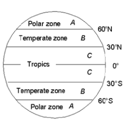
-In the map of Earth, where do the trade winds occur?
A) in the regions labeled A
B) in the regions labeled B
C) in the regions labeled C
D) in the regions labeled A, B, and C
سؤال
سؤال
سؤال
سؤال
سؤال
سؤال
سؤال
سؤال
سؤال
سؤال
سؤال
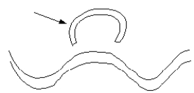
-In the map of a stream, the arrow is pointing to a(n) ____________.
A) natural levee
B) oxbow lake
C) point bar
D) sand dune
سؤال
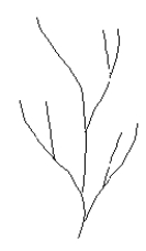
-What type of drainage pattern is depicted in the map?
A) dendritic
B) radial
C) rectangular
D) trellis
سؤال
سؤال
سؤال
سؤال
سؤال
سؤال
سؤال
سؤال
سؤال
سؤال
سؤال
سؤال
سؤال
سؤال
سؤال
سؤال
سؤال
سؤال
سؤال
سؤال
-The area labeled "X" is called the ______________.
A) backshore
B) foreshore
C) surf zone
D) swash zone
سؤال
-The area labeled "Y" is called the ______________.
A) backshore
B) foreshore
C) surf zone
D) swash zone
سؤال
-Together, the areas labeled "X" and "Y" are called the ______________.
A) backshore
B) foreshore
C) surf zone
D) swash zone
سؤال
سؤال
Use the schematic topographic profile of the Atlantic Ocean seafloor from New England to the mid-ocean ridge below to answer the following:
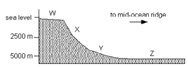
-The area labeled "W" is the __________.
A) abyssal plain
B) continental rise
C) continental shelf
D) continental slope
-The area labeled "W" is the __________.
A) abyssal plain
B) continental rise
C) continental shelf
D) continental slope
سؤال
Use the schematic topographic profile of the Atlantic Ocean seafloor from New England to the mid-ocean ridge below to answer the following:
-The area labeled "X" is the __________.
A) abyssal plain
B) continental rise
C) continental shelf
D) continental slope
-The area labeled "X" is the __________.
A) abyssal plain
B) continental rise
C) continental shelf
D) continental slope
سؤال
Use the schematic topographic profile of the Atlantic Ocean seafloor from New England to the mid-ocean ridge below to answer the following:
-The area labeled "Y" is the __________.
A) abyssal plain
B) continental rise
C) continental shelf
D) continental slope
-The area labeled "Y" is the __________.
A) abyssal plain
B) continental rise
C) continental shelf
D) continental slope
سؤال
Use the schematic topographic profile of the Atlantic Ocean seafloor from New England to the mid-ocean ridge below to answer the following:
-The area labeled "Z" is the __________.
A) abyssal plain
B) continental rise
C) continental shelf
D) continental slope
-The area labeled "Z" is the __________.
A) abyssal plain
B) continental rise
C) continental shelf
D) continental slope
سؤال
سؤال
سؤال
سؤال
سؤال
سؤال
سؤال
سؤال
سؤال
سؤال
سؤال

فتح الحزمة
قم بالتسجيل لفتح البطاقات في هذه المجموعة!
Unlock Deck
Unlock Deck
1/57
العب
ملء الشاشة (f)
Deck 12: Shaping Earths Surface: Streams, Coastlines, and Wind
1
Geologic processes powered by wind are called ___ processes.
A) eolian
B) alluvial
C) fluvial
A) eolian
B) alluvial
C) fluvial
A
2
Landscapes result from the interaction between which two geosystems?
A) climate and geodynamo
B) climate and plate tectonic
C) geodynamo and plate tectonic
A) climate and geodynamo
B) climate and plate tectonic
C) geodynamo and plate tectonic
B
3
On time scales of hundreds of millions of years, which of the following statements about landscape evolution is true?
A) Climatic variations are more important than tectonic uplift.
B) Tectonic uplift is more important than climatic variations.
C) Climatic variations and tectonic uplift are equally important.
A) Climatic variations are more important than tectonic uplift.
B) Tectonic uplift is more important than climatic variations.
C) Climatic variations and tectonic uplift are equally important.
B
4
What is the cause of the hazard associated with the "Skeleton Coast"?
A) moving shorelines
B) eroding cliffs
C) rip currents
D) coral reefs
A) moving shorelines
B) eroding cliffs
C) rip currents
D) coral reefs
فتح الحزمة
افتح القفل للوصول البطاقات البالغ عددها 57 في هذه المجموعة.
فتح الحزمة
k this deck
5
Most recorded shipwrecks occur within sight of a coastline.
فتح الحزمة
افتح القفل للوصول البطاقات البالغ عددها 57 في هذه المجموعة.
فتح الحزمة
k this deck
6
The factor that dictates whether water in a stream channel undergoes turbulent or laminar flow is _________.
A) the velocity of the water
B) the geometry of the stream channel
C) the viscosity of the water
D) all of the above
A) the velocity of the water
B) the geometry of the stream channel
C) the viscosity of the water
D) all of the above
فتح الحزمة
افتح القفل للوصول البطاقات البالغ عددها 57 في هذه المجموعة.
فتح الحزمة
k this deck
7
-In the map of Earth, where do the trade winds occur?
A) in the regions labeled A
B) in the regions labeled B
C) in the regions labeled C
D) in the regions labeled A, B, and C
فتح الحزمة
افتح القفل للوصول البطاقات البالغ عددها 57 في هذه المجموعة.
فتح الحزمة
k this deck
8
In which of the following flow patterns do streamlines run parallel to one another with no mixing between layers?
A) turbulent flow
B) laminar flow
C) both turbulent and laminar flow
A) turbulent flow
B) laminar flow
C) both turbulent and laminar flow
فتح الحزمة
افتح القفل للوصول البطاقات البالغ عددها 57 في هذه المجموعة.
فتح الحزمة
k this deck
9
In total, about how much dissolved matter is delivered annually to the ocean by river transport?
A) 2-4 million tons
B) 20-40 million tons
C) 200-400 million tons
D) 2-4 billion tons
A) 2-4 million tons
B) 20-40 million tons
C) 200-400 million tons
D) 2-4 billion tons
فتح الحزمة
افتح القفل للوصول البطاقات البالغ عددها 57 في هذه المجموعة.
فتح الحزمة
k this deck
10
What term is used to indicate a geologic process powered by wind?
A) Eolian
B) Fluvial
C) Lacustrine
D) Barometric
A) Eolian
B) Fluvial
C) Lacustrine
D) Barometric
فتح الحزمة
افتح القفل للوصول البطاقات البالغ عددها 57 في هذه المجموعة.
فتح الحزمة
k this deck
11
In geology, the term stream is applied to any body of water flowing over the surface, regardless of the size of that body of water.
فتح الحزمة
افتح القفل للوصول البطاقات البالغ عددها 57 في هذه المجموعة.
فتح الحزمة
k this deck
12
The rocky cliffs that characterize the Oregon coast are the result of tectonic subsidence.
فتح الحزمة
افتح القفل للوصول البطاقات البالغ عددها 57 في هذه المجموعة.
فتح الحزمة
k this deck
13
What type of flow can transport fine-grained clay particles?
A) laminar flow
B) turbulent flow
C) both laminar and turbulent flow
A) laminar flow
B) turbulent flow
C) both laminar and turbulent flow
فتح الحزمة
افتح القفل للوصول البطاقات البالغ عددها 57 في هذه المجموعة.
فتح الحزمة
k this deck
14
What type of transport mechanism forms ripples and dunes composed of sand grains?
A) wind
B) streams
C) streams and wind
A) wind
B) streams
C) streams and wind
فتح الحزمة
افتح القفل للوصول البطاقات البالغ عددها 57 في هذه المجموعة.
فتح الحزمة
k this deck
15
Which of the following terms describes the speed at which suspended particles become part of a stream bed?
A) capacity
B) discharge
C) settling velocity
A) capacity
B) discharge
C) settling velocity
فتح الحزمة
افتح القفل للوصول البطاقات البالغ عددها 57 في هذه المجموعة.
فتح الحزمة
k this deck
16
The steeper, downwind side of a sand dune is called a
A) sand drift.
B) ventifact.
C) slip face.
A) sand drift.
B) ventifact.
C) slip face.
فتح الحزمة
افتح القفل للوصول البطاقات البالغ عددها 57 في هذه المجموعة.
فتح الحزمة
k this deck
17
The slope of the upwind side of a sand dune is ___ the angle of repose.
A) greater than
B) equal to
C) less than
A) greater than
B) equal to
C) less than
فتح الحزمة
افتح القفل للوصول البطاقات البالغ عددها 57 في هذه المجموعة.
فتح الحزمة
k this deck
18
-In the map of a stream, the arrow is pointing to a(n) ____________.
A) natural levee
B) oxbow lake
C) point bar
D) sand dune
فتح الحزمة
افتح القفل للوصول البطاقات البالغ عددها 57 في هذه المجموعة.
فتح الحزمة
k this deck
19
-What type of drainage pattern is depicted in the map?
A) dendritic
B) radial
C) rectangular
D) trellis
فتح الحزمة
افتح القفل للوصول البطاقات البالغ عددها 57 في هذه المجموعة.
فتح الحزمة
k this deck
20
Stream valleys are made up of ___________ deposits.
A) point bar sand
B) floodplain
C) alluvial gravel
D) dune migration
A) point bar sand
B) floodplain
C) alluvial gravel
D) dune migration
فتح الحزمة
افتح القفل للوصول البطاقات البالغ عددها 57 في هذه المجموعة.
فتح الحزمة
k this deck
21
Potholes in river bottom bedrock form by
A) cascading water from a waterfall that wears away the rock.
B) the grinding action of a pebble or cobble in a swirling eddy.
C) the impact of a large rock moved by a strong current that makes a crater.
A) cascading water from a waterfall that wears away the rock.
B) the grinding action of a pebble or cobble in a swirling eddy.
C) the impact of a large rock moved by a strong current that makes a crater.
فتح الحزمة
افتح القفل للوصول البطاقات البالغ عددها 57 في هذه المجموعة.
فتح الحزمة
k this deck
22
Which of the following cities is built on a floodplain?
A) New York
B) San Francisco
C) St. Louis
A) New York
B) San Francisco
C) St. Louis
فتح الحزمة
افتح القفل للوصول البطاقات البالغ عددها 57 في هذه المجموعة.
فتح الحزمة
k this deck
23
What is the probability of a 50-year flood occurring next year along the Skykomish River in Washington State?
A) 2%
B) 10%
C) 50%
A) 2%
B) 10%
C) 50%
فتح الحزمة
افتح القفل للوصول البطاقات البالغ عددها 57 في هذه المجموعة.
فتح الحزمة
k this deck
24
What type of drainage would you expect to observe in the Valley and Ridge province of the southern Appalachians?
A) radial drainage
B) trellis drainage
C) dendritic drainage
A) radial drainage
B) trellis drainage
C) dendritic drainage
فتح الحزمة
افتح القفل للوصول البطاقات البالغ عددها 57 في هذه المجموعة.
فتح الحزمة
k this deck
25
Which of the following types of streams has many channels?
A) braided streams
B) meandering streams
C) both braided and meandering streams
A) braided streams
B) meandering streams
C) both braided and meandering streams
فتح الحزمة
افتح القفل للوصول البطاقات البالغ عددها 57 في هذه المجموعة.
فتح الحزمة
k this deck
26
The velocity of a river multiplied by the cross-sectional area of the river channel yields the river's
A) capacity.
B) discharge.
C) recurrence interval.
A) capacity.
B) discharge.
C) recurrence interval.
فتح الحزمة
افتح القفل للوصول البطاقات البالغ عددها 57 في هذه المجموعة.
فتح الحزمة
k this deck
27
Analysis of sediment transport over the entire United States provides evidence that global climate change is responsible for a(n) ___ in streamflow.
A) increase
B) decrease
C) erratic and unpredictable variation
A) increase
B) decrease
C) erratic and unpredictable variation
فتح الحزمة
افتح القفل للوصول البطاقات البالغ عددها 57 في هذه المجموعة.
فتح الحزمة
k this deck
28
Alluvial fans form
A) where rivers meet an ocean basin.
B) at a mountain front, where rivers meet a sudden topographic change.
C) along the outside bank of a meander.
A) where rivers meet an ocean basin.
B) at a mountain front, where rivers meet a sudden topographic change.
C) along the outside bank of a meander.
فتح الحزمة
افتح القفل للوصول البطاقات البالغ عددها 57 في هذه المجموعة.
فتح الحزمة
k this deck
29
Stream power is not a function of which of the following?
A) river discharge
B) river slope
C) sediment volume
A) river discharge
B) river slope
C) sediment volume
فتح الحزمة
افتح القفل للوصول البطاقات البالغ عددها 57 في هذه المجموعة.
فتح الحزمة
k this deck
30
Which of the following statements about stream power is true?
A) Increasing stream power makes the streambed less susceptible to erosion.
B) Increasing stream power makes the streambed more susceptible to erosion.
C) Increasing stream power does not change the streambed's susceptibility to erosion.
A) Increasing stream power makes the streambed less susceptible to erosion.
B) Increasing stream power makes the streambed more susceptible to erosion.
C) Increasing stream power does not change the streambed's susceptibility to erosion.
فتح الحزمة
افتح القفل للوصول البطاقات البالغ عددها 57 في هذه المجموعة.
فتح الحزمة
k this deck
31
Potholes in river bottom bedrock form by
A) cascading water from a waterfall that wears away the rock.
B) the grinding action of a pebble or cobble in a swirling eddy.
C) the impact of a large rock moved by a strong current that makes a crater.
A) cascading water from a waterfall that wears away the rock.
B) the grinding action of a pebble or cobble in a swirling eddy.
C) the impact of a large rock moved by a strong current that makes a crater.
فتح الحزمة
افتح القفل للوصول البطاقات البالغ عددها 57 في هذه المجموعة.
فتح الحزمة
k this deck
32
The muddy or sandy areas that are exposed during low tide but are flooded at high tide are called
A) estuaries.
B) tidal flats.
C) surf zones.
A) estuaries.
B) tidal flats.
C) surf zones.
فتح الحزمة
افتح القفل للوصول البطاقات البالغ عددها 57 في هذه المجموعة.
فتح الحزمة
k this deck
33
Which of the following terms describes the region of breaking waves near the shoreline?
A) surf zone
B) swash zone
C) tidal flat
A) surf zone
B) swash zone
C) tidal flat
فتح الحزمة
افتح القفل للوصول البطاقات البالغ عددها 57 في هذه المجموعة.
فتح الحزمة
k this deck
34
Large waves caused by major storms can move sand on the ocean bottom at depths up to
A) 0.5 meters.
B) 5 meters.
C) 50 meters.
A) 0.5 meters.
B) 5 meters.
C) 50 meters.
فتح الحزمة
افتح القفل للوصول البطاقات البالغ عددها 57 في هذه المجموعة.
فتح الحزمة
k this deck
35
Hurricanes form over tropical parts of the Earth's oceans where sea-surface temperatures are equal to or exceed
A) 18°C.
B) 50°C.
C) 26°C.
A) 18°C.
B) 50°C.
C) 26°C.
فتح الحزمة
افتح القفل للوصول البطاقات البالغ عددها 57 في هذه المجموعة.
فتح الحزمة
k this deck
36
The phenomenon associated with Hurricane Katrina that resulted in the most catastrophic damage in New Orleans was the
A) storm surge.
B) high winds.
C) flood tide.
A) storm surge.
B) high winds.
C) flood tide.
فتح الحزمة
افتح القفل للوصول البطاقات البالغ عددها 57 في هذه المجموعة.
فتح الحزمة
k this deck
37
Which stream conditions favor the formation of a braided stream channel?
A) a high sediment load and consistent discharge
B) a low sediment load and consistent discharge
C) a high sediment load and variable discharge
D) a low sediment load and variable discharge
A) a high sediment load and consistent discharge
B) a low sediment load and consistent discharge
C) a high sediment load and variable discharge
D) a low sediment load and variable discharge
فتح الحزمة
افتح القفل للوصول البطاقات البالغ عددها 57 في هذه المجموعة.
فتح الحزمة
k this deck
38
Alluvial fans characteristically form in which of the geologic environments listed below.
A) A coastal plain delta
B) A low gradient meandering stream
C) A sharply defined mountain front
D) An advancing glacial terminus
A) A coastal plain delta
B) A low gradient meandering stream
C) A sharply defined mountain front
D) An advancing glacial terminus
فتح الحزمة
افتح القفل للوصول البطاقات البالغ عددها 57 في هذه المجموعة.
فتح الحزمة
k this deck
39
-The area labeled "X" is called the ______________.
A) backshore
B) foreshore
C) surf zone
D) swash zone
فتح الحزمة
افتح القفل للوصول البطاقات البالغ عددها 57 في هذه المجموعة.
فتح الحزمة
k this deck
40
-The area labeled "Y" is called the ______________.
A) backshore
B) foreshore
C) surf zone
D) swash zone
فتح الحزمة
افتح القفل للوصول البطاقات البالغ عددها 57 في هذه المجموعة.
فتح الحزمة
k this deck
41
-Together, the areas labeled "X" and "Y" are called the ______________.
A) backshore
B) foreshore
C) surf zone
D) swash zone
فتح الحزمة
افتح القفل للوصول البطاقات البالغ عددها 57 في هذه المجموعة.
فتح الحزمة
k this deck
42
The best way to preserve natural beach environments is to ___________.
A) build groins
B) build levee systems
C) truck in sand
D) leave it alone
A) build groins
B) build levee systems
C) truck in sand
D) leave it alone
فتح الحزمة
افتح القفل للوصول البطاقات البالغ عددها 57 في هذه المجموعة.
فتح الحزمة
k this deck
43
Use the schematic topographic profile of the Atlantic Ocean seafloor from New England to the mid-ocean ridge below to answer the following:
-The area labeled "W" is the __________.
A) abyssal plain
B) continental rise
C) continental shelf
D) continental slope
-The area labeled "W" is the __________.
A) abyssal plain
B) continental rise
C) continental shelf
D) continental slope
فتح الحزمة
افتح القفل للوصول البطاقات البالغ عددها 57 في هذه المجموعة.
فتح الحزمة
k this deck
44
Use the schematic topographic profile of the Atlantic Ocean seafloor from New England to the mid-ocean ridge below to answer the following:
-The area labeled "X" is the __________.
A) abyssal plain
B) continental rise
C) continental shelf
D) continental slope
-The area labeled "X" is the __________.
A) abyssal plain
B) continental rise
C) continental shelf
D) continental slope
فتح الحزمة
افتح القفل للوصول البطاقات البالغ عددها 57 في هذه المجموعة.
فتح الحزمة
k this deck
45
Use the schematic topographic profile of the Atlantic Ocean seafloor from New England to the mid-ocean ridge below to answer the following:
-The area labeled "Y" is the __________.
A) abyssal plain
B) continental rise
C) continental shelf
D) continental slope
-The area labeled "Y" is the __________.
A) abyssal plain
B) continental rise
C) continental shelf
D) continental slope
فتح الحزمة
افتح القفل للوصول البطاقات البالغ عددها 57 في هذه المجموعة.
فتح الحزمة
k this deck
46
Use the schematic topographic profile of the Atlantic Ocean seafloor from New England to the mid-ocean ridge below to answer the following:
-The area labeled "Z" is the __________.
A) abyssal plain
B) continental rise
C) continental shelf
D) continental slope
-The area labeled "Z" is the __________.
A) abyssal plain
B) continental rise
C) continental shelf
D) continental slope
فتح الحزمة
افتح القفل للوصول البطاقات البالغ عددها 57 في هذه المجموعة.
فتح الحزمة
k this deck
47
Which of the following parts of a beach is the farthest inland?
A) the foreshore
B) the dune belt
C) the backshore
D) the surf zone
A) the foreshore
B) the dune belt
C) the backshore
D) the surf zone
فتح الحزمة
افتح القفل للوصول البطاقات البالغ عددها 57 في هذه المجموعة.
فتح الحزمة
k this deck
48
Which of the following is not a shoreline depositional landform?
A) spit
B) barrier island
C) sand bar
D) sea stack
A) spit
B) barrier island
C) sand bar
D) sea stack
فتح الحزمة
افتح القفل للوصول البطاقات البالغ عددها 57 في هذه المجموعة.
فتح الحزمة
k this deck
49
Which of the following statements is true?
A) Wind is a more effective erosion agent in wet climates.
B) Wind is a more effective erosion agent in dry climates.
C) Wind is an equally effective erosion agent in wet and dry climates.
A) Wind is a more effective erosion agent in wet climates.
B) Wind is a more effective erosion agent in dry climates.
C) Wind is an equally effective erosion agent in wet and dry climates.
فتح الحزمة
افتح القفل للوصول البطاقات البالغ عددها 57 في هذه المجموعة.
فتح الحزمة
k this deck
50
What is the geologic term for the distinctive, dark-brown coating that forms on rock surfaces in the desert?
A) desert varnish
B) loess
C) desert pavement
A) desert varnish
B) loess
C) desert pavement
فتح الحزمة
افتح القفل للوصول البطاقات البالغ عددها 57 في هذه المجموعة.
فتح الحزمة
k this deck
51
Which of the following would you least expect to find in a desert?
A) playa lakes
B) rounded, soil-covered hills
C) steep river valleys and gorges
A) playa lakes
B) rounded, soil-covered hills
C) steep river valleys and gorges
فتح الحزمة
افتح القفل للوصول البطاقات البالغ عددها 57 في هذه المجموعة.
فتح الحزمة
k this deck
52
Where would you expect to find evaporite sediments in a desert environment?
A) playa lake
B) alluvial fan
C) dune field
A) playa lake
B) alluvial fan
C) dune field
فتح الحزمة
افتح القفل للوصول البطاقات البالغ عددها 57 في هذه المجموعة.
فتح الحزمة
k this deck
53
Which of the following is not an area where deserts typically occur?
A) regions of sinking air masses
B) the mid-northern latitudes around 30° N latitude
C) the mid-southern latitudes around 30° S latitude
D) regions immediately upwind of large coastal mountains
A) regions of sinking air masses
B) the mid-northern latitudes around 30° N latitude
C) the mid-southern latitudes around 30° S latitude
D) regions immediately upwind of large coastal mountains
فتح الحزمة
افتح القفل للوصول البطاقات البالغ عددها 57 في هذه المجموعة.
فتح الحزمة
k this deck
54
Approximately what percentage of Earth's deserts are covered by sand?
A) 5%
B) 20%
C) 50%
D) 80%
A) 5%
B) 20%
C) 50%
D) 80%
فتح الحزمة
افتح القفل للوصول البطاقات البالغ عددها 57 في هذه المجموعة.
فتح الحزمة
k this deck
55
The northern part of the Sahara Desert is currently receding southward.
فتح الحزمة
افتح القفل للوصول البطاقات البالغ عددها 57 في هذه المجموعة.
فتح الحزمة
k this deck
56
In desert environments physical weathering is predominant over chemical weathering.
فتح الحزمة
افتح القفل للوصول البطاقات البالغ عددها 57 في هذه المجموعة.
فتح الحزمة
k this deck
57
In deserts, stream flow does much erosional work.
فتح الحزمة
افتح القفل للوصول البطاقات البالغ عددها 57 في هذه المجموعة.
فتح الحزمة
k this deck
فتح الحزمة
افتح القفل للوصول البطاقات البالغ عددها 57 في هذه المجموعة.


