Deck 21: Dry Regions: the Geology of Deserts
ملء الشاشة (f)
سؤال
سؤال
سؤال
سؤال
سؤال
سؤال
سؤال
سؤال
سؤال
سؤال
The measured rainfall shown in the figure below is characteristic of a ________. 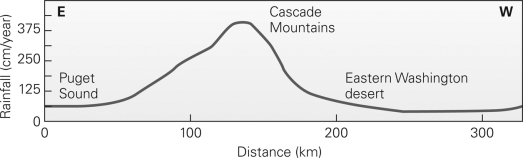
A)coastal desert
B)subtropical desert
C)rain-shadow desert
D)continental-interior desert
A)coastal desert
B)subtropical desert
C)rain-shadow desert
D)continental-interior desert
سؤال
سؤال
سؤال
سؤال
سؤال
سؤال
سؤال
سؤال
سؤال
The figure below illustrates the formation of a ________. 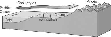
A)coastal desert
B)subtropical desert
C)rain-shadow desert
D)continental-interior desert
A)coastal desert
B)subtropical desert
C)rain-shadow desert
D)continental-interior desert
سؤال
سؤال
سؤال
سؤال
سؤال
In the figure below,the sand grains are being transported by ________. 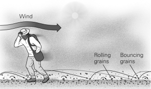
A)suspension
B)saltation
C)surface creep
D)deflation
A)suspension
B)saltation
C)surface creep
D)deflation
سؤال
سؤال
سؤال
سؤال
When fine-grained sediment is blown away as shown in the figure below,the coarser sediment left behind is known as ________. 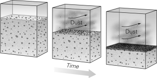
A)a sabkha
B)ventifacts
C)a lag deposit
D)talus
A)a sabkha
B)ventifacts
C)a lag deposit
D)talus
سؤال
سؤال
سؤال
سؤال
سؤال
سؤال
سؤال
سؤال
سؤال
سؤال
As shown in the figure below,wind erosion can create a faceted rock known as a ________. 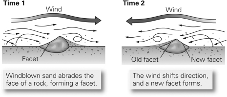
A)ventifact
B)lag deposit
C)yardang
D)wadi
A)ventifact
B)lag deposit
C)yardang
D)wadi
سؤال
سؤال
سؤال
سؤال
سؤال
سؤال
سؤال
سؤال
سؤال
سؤال
سؤال
سؤال

فتح الحزمة
قم بالتسجيل لفتح البطاقات في هذه المجموعة!
Unlock Deck
Unlock Deck
1/50
العب
ملء الشاشة (f)
Deck 21: Dry Regions: the Geology of Deserts
1
A desert may form along a coastline because a ________.
A)warm current warms and dries the air
B)warm current forces hot air inland
C)cold current cools and dries the air
D)cold current forces hot air inland
A)warm current warms and dries the air
B)warm current forces hot air inland
C)cold current cools and dries the air
D)cold current forces hot air inland
C
2
Evaporite deposits in coastal,subtropical regions derived from the evaporation of seawater stranded above high tide are termed ________.
A)mirages
B)caliches
C)sabkhas
D)yardangs
A)mirages
B)caliches
C)sabkhas
D)yardangs
C
3
At 30° north latitude,at the northern edge of tropical (Hadley)cell convection in the northern hemisphere,________.
A)cool,dry air sinks,becoming drier as it heats up
B)warm,moist air rises,increasing in relative humidity as it rises
C)warm,dry air rises,becoming cooler
D)cool moist air sinks,providing abundant rainfall
A)cool,dry air sinks,becoming drier as it heats up
B)warm,moist air rises,increasing in relative humidity as it rises
C)warm,dry air rises,becoming cooler
D)cool moist air sinks,providing abundant rainfall
A
4
The Sahara is a desert primarily because it is located ________.
A)in the subtropics
B)within the rain shadow of a mountain range
C)near the center of a large continent
D)next to a cold ocean current
A)in the subtropics
B)within the rain shadow of a mountain range
C)near the center of a large continent
D)next to a cold ocean current
فتح الحزمة
افتح القفل للوصول البطاقات البالغ عددها 50 في هذه المجموعة.
فتح الحزمة
k this deck
5
The definition of a desert depends on a region's ________.
A)latitude
B)elevation
C)aridity
D)temperature
A)latitude
B)elevation
C)aridity
D)temperature
فتح الحزمة
افتح القفل للوصول البطاقات البالغ عددها 50 في هذه المجموعة.
فتح الحزمة
k this deck
6
The Gobi in Mongolia is a desert primarily because it is located ________.
A)in the subtropics
B)in a polar region
C)near the center of a large continent
D)next to a cold ocean current
A)in the subtropics
B)in a polar region
C)near the center of a large continent
D)next to a cold ocean current
فتح الحزمة
افتح القفل للوصول البطاقات البالغ عددها 50 في هذه المجموعة.
فتح الحزمة
k this deck
7
During heavy rainstorms,rates of physical weathering and erosion are ________.
A)greater in humid climates than in deserts because dry desert soils soak up all the available moisture
B)greater in deserts than in humid climates because soil tends to be more easily eroded in deserts than in humid regions
C)greater in humid climates than in deserts because vegetation tends to break up the soil
D)about equally fast in both deserts and humid climates
فتح الحزمة
افتح القفل للوصول البطاقات البالغ عددها 50 في هذه المجموعة.
فتح الحزمة
k this deck
8
The Atacama Desert in Chile is a desert primarily because it is located ________.
A)in the subtropics
B)near the south pole
C)near the center of a large continent
D)next to a cold ocean current
A)in the subtropics
B)near the south pole
C)near the center of a large continent
D)next to a cold ocean current
فتح الحزمة
افتح القفل للوصول البطاقات البالغ عددها 50 في هذه المجموعة.
فتح الحزمة
k this deck
9
The deserts found in the western United States are primarily the result of being located ________.
A)in the subtropics
B)within the rain shadow of one or more mountain ranges
C)near the center of a large continent
D)next to a cold ocean current
A)in the subtropics
B)within the rain shadow of one or more mountain ranges
C)near the center of a large continent
D)next to a cold ocean current
فتح الحزمة
افتح القفل للوصول البطاقات البالغ عددها 50 في هذه المجموعة.
فتح الحزمة
k this deck
10
The measured rainfall shown in the figure below is characteristic of a ________.
A)coastal desert
B)subtropical desert
C)rain-shadow desert
D)continental-interior desert
A)coastal desert
B)subtropical desert
C)rain-shadow desert
D)continental-interior desert
فتح الحزمة
افتح القفل للوصول البطاقات البالغ عددها 50 في هذه المجموعة.
فتح الحزمة
k this deck
11
Desert climate associated with a rain shadow is found ________.
A)on the windward side of mountain ranges
B)on the leeward side of mountain ranges
C)in the middle of flat plains
D)along continental coastlines
A)on the windward side of mountain ranges
B)on the leeward side of mountain ranges
C)in the middle of flat plains
D)along continental coastlines
فتح الحزمة
افتح القفل للوصول البطاقات البالغ عددها 50 في هذه المجموعة.
فتح الحزمة
k this deck
12
The most expansive hot deserts on Earth occur in the ________.
A)tropics,at or near the equator
B)subtropics,between 20° and 30° north or south of the equator
C)temperate zone,between 30° and 50° north or south of the equator
D)latitudes higher than 50° north or south of the equator
A)tropics,at or near the equator
B)subtropics,between 20° and 30° north or south of the equator
C)temperate zone,between 30° and 50° north or south of the equator
D)latitudes higher than 50° north or south of the equator
فتح الحزمة
افتح القفل للوصول البطاقات البالغ عددها 50 في هذه المجموعة.
فتح الحزمة
k this deck
13
Coastal region deserts are most likely near ocean currents that are ________.
A)warm
B)cold
C)flowing east
D)flowing west
A)warm
B)cold
C)flowing east
D)flowing west
فتح الحزمة
افتح القفل للوصول البطاقات البالغ عددها 50 في هذه المجموعة.
فتح الحزمة
k this deck
14
Most hot deserts ________.
A)retain their high temperatures throughout the night because there is no vegetation to absorb heat from the sediment at the surface
B)cool off greatly at night because of sparse vegetation,dry air,and little cloud cover
C)cool off by no more than 8°C on most nights
D)gain additional heat at night because the desert air rises
فتح الحزمة
افتح القفل للوصول البطاقات البالغ عددها 50 في هذه المجموعة.
فتح الحزمة
k this deck
15
According to the textbook,the highest recorded temperature on Earth was in a ________.
A)tropical rainforest in Brazil
B)low-latitude,high-elevation desert in Mexico
C)high-latitude,high-elevation desert in Mongolia
D)low-latitude,low-elevation desert in Libya
A)tropical rainforest in Brazil
B)low-latitude,high-elevation desert in Mexico
C)high-latitude,high-elevation desert in Mongolia
D)low-latitude,low-elevation desert in Libya
فتح الحزمة
افتح القفل للوصول البطاقات البالغ عددها 50 في هذه المجموعة.
فتح الحزمة
k this deck
16
Deserts represent ________ of Earth's surface.
A)less than 5%
B)about 10%
C)about 25%
D)more than 50%
A)less than 5%
B)about 10%
C)about 25%
D)more than 50%
فتح الحزمة
افتح القفل للوصول البطاقات البالغ عددها 50 في هذه المجموعة.
فتح الحزمة
k this deck
17
A salt-encrusted muddy tidal flat is known as a ________.
A)wadi
B)pediment
C)sabkha
D)bajada
A)wadi
B)pediment
C)sabkha
D)bajada
فتح الحزمة
افتح القفل للوصول البطاقات البالغ عددها 50 في هذه المجموعة.
فتح الحزمة
k this deck
18
To qualify as a desert,a region must ________.
A)be hot,with a mean annual temperature greater than 25°C (77°F)
B)be arid,with less than 15% of the ground surface vegetated
C)have a mean annual temperature greater than 25°C and less than 5 cm annual rainfall
D)have no rainfall three out of four seasons
A)be hot,with a mean annual temperature greater than 25°C (77°F)
B)be arid,with less than 15% of the ground surface vegetated
C)have a mean annual temperature greater than 25°C and less than 5 cm annual rainfall
D)have no rainfall three out of four seasons
فتح الحزمة
افتح القفل للوصول البطاقات البالغ عددها 50 في هذه المجموعة.
فتح الحزمة
k this deck
19
The figure below illustrates the formation of a ________.
A)coastal desert
B)subtropical desert
C)rain-shadow desert
D)continental-interior desert
A)coastal desert
B)subtropical desert
C)rain-shadow desert
D)continental-interior desert
فتح الحزمة
افتح القفل للوصول البطاقات البالغ عددها 50 في هذه المجموعة.
فتح الحزمة
k this deck
20
Very hot air just above the ground creates a wavering pool of light on the ground known as a(n)________.
A)sabkha
B)wadi
C)arroyo
D)mirage
A)sabkha
B)wadi
C)arroyo
D)mirage
فتح الحزمة
افتح القفل للوصول البطاقات البالغ عددها 50 في هذه المجموعة.
فتح الحزمة
k this deck
21
Calcrete (caliche)forms in a desert climate through the dissolution and the reprecipitation of ________ during and after rainstorms.
A)manganese oxide
B)quartz
C)calcite
D)iron oxide
A)manganese oxide
B)quartz
C)calcite
D)iron oxide
فتح الحزمة
افتح القفل للوصول البطاقات البالغ عددها 50 في هذه المجموعة.
فتح الحزمة
k this deck
22
Desert varnish consists of ________.
A)pesticide and other pollutant residues
B)dusts of iron and magnesium oxides
C)dust deposits affected by microorganisms
D)carbonate cements with iron impurities (e.g.,siderite)
A)pesticide and other pollutant residues
B)dusts of iron and magnesium oxides
C)dust deposits affected by microorganisms
D)carbonate cements with iron impurities (e.g.,siderite)
فتح الحزمة
افتح القفل للوصول البطاقات البالغ عددها 50 في هذه المجموعة.
فتح الحزمة
k this deck
23
The saltation of sand involves ________.
A)spherical grains rolling along the surface of dunes
B)grains traveling short distances (approximately 1 m)in the air
C)grains traveling long distances (approximately 1-100 km)in the air by strong winds
D)the mixing of mineral sand and salt to form a weakly cemented soil
A)spherical grains rolling along the surface of dunes
B)grains traveling short distances (approximately 1 m)in the air
C)grains traveling long distances (approximately 1-100 km)in the air by strong winds
D)the mixing of mineral sand and salt to form a weakly cemented soil
فتح الحزمة
افتح القفل للوصول البطاقات البالغ عددها 50 في هذه المجموعة.
فتح الحزمة
k this deck
24
In the figure below,the sand grains are being transported by ________.
A)suspension
B)saltation
C)surface creep
D)deflation
A)suspension
B)saltation
C)surface creep
D)deflation
فتح الحزمة
افتح القفل للوصول البطاقات البالغ عددها 50 في هذه المجموعة.
فتح الحزمة
k this deck
25
Most of the erosion in desert environments is caused by ________.
A)wind
B)surface water
C)ground water
D)salt wedging
A)wind
B)surface water
C)ground water
D)salt wedging
فتح الحزمة
افتح القفل للوصول البطاقات البالغ عددها 50 في هذه المجموعة.
فتح الحزمة
k this deck
26
The process of lowering the surface of the land by wind erosion is known as ________.
A)deflation
B)desertification
C)saltation
D)calcretion
A)deflation
B)desertification
C)saltation
D)calcretion
فتح الحزمة
افتح القفل للوصول البطاقات البالغ عددها 50 في هذه المجموعة.
فتح الحزمة
k this deck
27
Badlands are characterized by ________.
A)thick caliche crusts
B)closely spaced parallel drainages
C)sabkhas
D)perennial streams
A)thick caliche crusts
B)closely spaced parallel drainages
C)sabkhas
D)perennial streams
فتح الحزمة
افتح القفل للوصول البطاقات البالغ عددها 50 في هذه المجموعة.
فتح الحزمة
k this deck
28
When fine-grained sediment is blown away as shown in the figure below,the coarser sediment left behind is known as ________.
A)a sabkha
B)ventifacts
C)a lag deposit
D)talus
A)a sabkha
B)ventifacts
C)a lag deposit
D)talus
فتح الحزمة
افتح القفل للوصول البطاقات البالغ عددها 50 في هذه المجموعة.
فتح الحزمة
k this deck
29
A rock that has been significantly reshaped on multiple surfaces by windborne particles and sometimes has a sharp edge is a(n)________.
A)inselberg
B)ventifact
C)wadi
D)yardang
A)inselberg
B)ventifact
C)wadi
D)yardang
فتح الحزمة
افتح القفل للوصول البطاقات البالغ عددها 50 في هذه المجموعة.
فتح الحزمة
k this deck
30
Compared with humid climates,the rates of chemical weathering in deserts are ________.
A)much faster
B)much slower
C)very similar
D)too variable to understand
A)much faster
B)much slower
C)very similar
D)too variable to understand
فتح الحزمة
افتح القفل للوصول البطاقات البالغ عددها 50 في هذه المجموعة.
فتح الحزمة
k this deck
31
Iron-rich,well oxidized strata will be ________.
A)tan
B)gray
C)green
D)dark red
A)tan
B)gray
C)green
D)dark red
فتح الحزمة
افتح القفل للوصول البطاقات البالغ عددها 50 في هذه المجموعة.
فتح الحزمة
k this deck
32
Fine-grained sediment,such as dust and silt,is transported by wind in ________.
A)suspension
B)saltation
C)deflation
D)surface creep
A)suspension
B)saltation
C)deflation
D)surface creep
فتح الحزمة
افتح القفل للوصول البطاقات البالغ عددها 50 في هذه المجموعة.
فتح الحزمة
k this deck
33
A mushroom-shaped landform consisting of a column of less resistant rock supporting a broader extent of wind-resistant rock is termed a ________.
A)blowout
B)ventifact
C)wadi
D)yardang
A)blowout
B)ventifact
C)wadi
D)yardang
فتح الحزمة
افتح القفل للوصول البطاقات البالغ عددها 50 في هذه المجموعة.
فتح الحزمة
k this deck
34
Talus aprons represent accumulations of ________.
A)angular debris at the base of a hill
B)lag deposits
C)coarse sediment in a deflation basin
D)loess at the edge of a desert
A)angular debris at the base of a hill
B)lag deposits
C)coarse sediment in a deflation basin
D)loess at the edge of a desert
فتح الحزمة
افتح القفل للوصول البطاقات البالغ عددها 50 في هذه المجموعة.
فتح الحزمة
k this deck
35
Native Americans produced petroglyphs by etching into ________.
A)rocks that had been subjected to case hardening
B)rocks that had been coated with desert varnish
C)dark basalts
D)obsidian
A)rocks that had been subjected to case hardening
B)rocks that had been coated with desert varnish
C)dark basalts
D)obsidian
فتح الحزمة
افتح القفل للوصول البطاقات البالغ عددها 50 في هذه المجموعة.
فتح الحزمة
k this deck
36
How do chimneys (also called hoodoos)and yardangs differ?
A)Yardangs are formed by the erosion of water,whereas chimneys are formed by evaporation.
B)Chimneys are formed by evaporation,whereas yardangs are formed by the erosion of water.
C)Chimneys are fossilized trunks of saguaro and other large cactus,whereas yardangs are not.
D)Chimneys are remnants of physical erosion,whereas yardangs are remnants of wind erosion.
فتح الحزمة
افتح القفل للوصول البطاقات البالغ عددها 50 في هذه المجموعة.
فتح الحزمة
k this deck
37
The process of lowering the land surface by wind erosion is known as ________.
A)saltation
B)deflation
C)desertification
D)escarpment
A)saltation
B)deflation
C)desertification
D)escarpment
فتح الحزمة
افتح القفل للوصول البطاقات البالغ عددها 50 في هذه المجموعة.
فتح الحزمة
k this deck
38
As shown in the figure below,wind erosion can create a faceted rock known as a ________.
A)ventifact
B)lag deposit
C)yardang
D)wadi
A)ventifact
B)lag deposit
C)yardang
D)wadi
فتح الحزمة
افتح القفل للوصول البطاقات البالغ عددها 50 في هذه المجموعة.
فتح الحزمة
k this deck
39
A(n)________ consists of sand and gravel deposited by ephemeral distributary channels that occur where a gully or a canyon discharges from its mouth.
A)alluvial fan
B)ventifact
C)wadi
D)yardang
A)alluvial fan
B)ventifact
C)wadi
D)yardang
فتح الحزمة
افتح القفل للوصول البطاقات البالغ عددها 50 في هذه المجموعة.
فتح الحزمة
k this deck
40
An arroyo is a steep-sided,linear trough produced by ________.
A)normal faulting or other extensional processes
B)wind erosion of more susceptible layers
C)scouring erosion by water and sediment during flash floods
D)cliff retreat
A)normal faulting or other extensional processes
B)wind erosion of more susceptible layers
C)scouring erosion by water and sediment during flash floods
D)cliff retreat
فتح الحزمة
افتح القفل للوصول البطاقات البالغ عددها 50 في هذه المجموعة.
فتح الحزمة
k this deck
41
Areas with relatively scarce sand and constantly shifting winds will develop ________ dunes.
A)star
B)barchans
C)parabolic
D)longitudinal
A)star
B)barchans
C)parabolic
D)longitudinal
فتح الحزمة
افتح القفل للوصول البطاقات البالغ عددها 50 في هذه المجموعة.
فتح الحزمة
k this deck
42
Vegetation in the desert consists of ________.
A)cacti only
B)extensive grasslands with water-seeking deep roots
C)scattered,scrub-like plants as succulents,such as cacti,with adaptations to obtain and retain as much water as they can
D)forests of tall,broad-leafed trees
A)cacti only
B)extensive grasslands with water-seeking deep roots
C)scattered,scrub-like plants as succulents,such as cacti,with adaptations to obtain and retain as much water as they can
D)forests of tall,broad-leafed trees
فتح الحزمة
افتح القفل للوصول البطاقات البالغ عددها 50 في هذه المجموعة.
فتح الحزمة
k this deck
43
Which of the following is NOT an adaptation of plants that helps them survive in deserts?
A)a thick waxy outer coating and needlelike leaves
B)shallow,expansive root systems that can uptake infiltrated water over a broad area
C)succulence (tissues that retain moisture for a long period of time)
D)thin-skinned seeds that can quickly germinate when it rains
A)a thick waxy outer coating and needlelike leaves
B)shallow,expansive root systems that can uptake infiltrated water over a broad area
C)succulence (tissues that retain moisture for a long period of time)
D)thin-skinned seeds that can quickly germinate when it rains
فتح الحزمة
افتح القفل للوصول البطاقات البالغ عددها 50 في هذه المجموعة.
فتح الحزمة
k this deck
44
Over time,alluvial fans may merge to form a ________.
A)wadi
B)talus apron
C)playa
D)bajada
A)wadi
B)talus apron
C)playa
D)bajada
فتح الحزمة
افتح القفل للوصول البطاقات البالغ عددها 50 في هذه المجموعة.
فتح الحزمة
k this deck
45
Fine-grained,wind-blown sediments are eventually deposited as ________.
A)loess
B)ventifacts
C)dunes
D)desert pavement
A)loess
B)ventifacts
C)dunes
D)desert pavement
فتح الحزمة
افتح القفل للوصول البطاقات البالغ عددها 50 في هذه المجموعة.
فتح الحزمة
k this deck
46
After extensive erosion of a hill in a desert environment,the small remnant surrounded by alluvium-filled basins is known as a(n)________.
A)inselberg
B)hogback
C)questa
D)mesa
A)inselberg
B)hogback
C)questa
D)mesa
فتح الحزمة
افتح القفل للوصول البطاقات البالغ عددها 50 في هذه المجموعة.
فتح الحزمة
k this deck
47
Conversion of productive land to desert is known as ________.
A)deflation
B)saltation
C)degradation
D)desertification
A)deflation
B)saltation
C)degradation
D)desertification
فتح الحزمة
افتح القفل للوصول البطاقات البالغ عددها 50 في هذه المجموعة.
فتح الحزمة
k this deck
48
The geometry of sand dunes is NOT strongly influenced by the ________.
A)strength of the wind
B)consistency of wind direction
C)abundance of sand
D)timing of the monsoon season
A)strength of the wind
B)consistency of wind direction
C)abundance of sand
D)timing of the monsoon season
فتح الحزمة
افتح القفل للوصول البطاقات البالغ عددها 50 في هذه المجموعة.
فتح الحزمة
k this deck
49
Which statement about desert life is correct?
A)Mammals,unlike reptiles and birds,very rarely inhabit deserts.
B)Mammals are the most common desert inhabitants among vertebrates and are most active at midday.
C)Mammals survive in deserts but are less conspicuous than birds and reptiles because they are generally less active at midday.
D)Herbivorous mammals are found in desert environments,whereas carnivorous mammals are not.
فتح الحزمة
افتح القفل للوصول البطاقات البالغ عددها 50 في هذه المجموعة.
فتح الحزمة
k this deck
50
An apron-shaped pile of alluvium that forms at the mouth of a canyon is known as a(n)________.
A)playa
B)sabkha
C)alluvial fan
D)inselberg
A)playa
B)sabkha
C)alluvial fan
D)inselberg
فتح الحزمة
افتح القفل للوصول البطاقات البالغ عددها 50 في هذه المجموعة.
فتح الحزمة
k this deck
فتح الحزمة
افتح القفل للوصول البطاقات البالغ عددها 50 في هذه المجموعة.


