Deck 16: Marine Geology: the Study of Ocean Basins and Coasts
ملء الشاشة (f)
سؤال
سؤال
سؤال
سؤال
سؤال
سؤال
سؤال
سؤال
In the figure below, which letter represents the active continental margin? 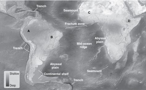
A)A
B)B
C)C
D)D
A)A
B)B
C)C
D)D
سؤال
سؤال
Which location on the figure below is the continental slope? 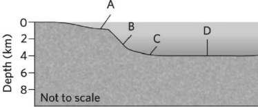
A)A
B)B
C)C
D)D
A)A
B)B
C)C
D)D
سؤال
Which location is the passive continental margin on the image below? 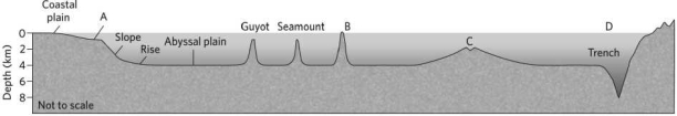
A)A
B)B
C)C
D)D
A)A
B)B
C)C
D)D
سؤال
سؤال
سؤال
سؤال
سؤال
The schematic shown below illustrates a(n) 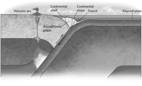
A)emergent coast.
B)submergent coast.
C)active margin.
D)passive margin.
A)emergent coast.
B)submergent coast.
C)active margin.
D)passive margin.
سؤال
سؤال
سؤال
سؤال
سؤال
In the figure below, which direction is the longshore drift? 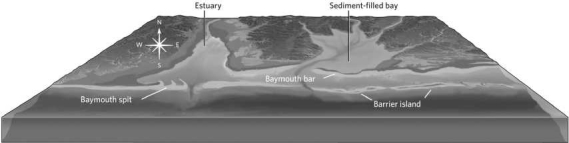
A)south
B)east
C)west
D)It is not possible to tell.
A)south
B)east
C)west
D)It is not possible to tell.
سؤال
In the photograph below, notice how the waves are approaching the shore at an angle to the shoreline. This is an example of 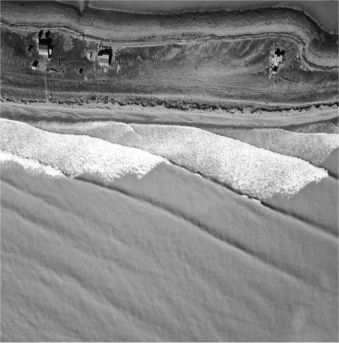
A)wave refraction.
B)swash.
C)a breaker.
D)backwash.
A)wave refraction.
B)swash.
C)a breaker.
D)backwash.
سؤال
سؤال
What will eventually happen to the headlands in the figure below? 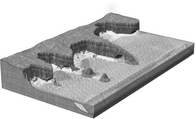
A)They will join as the bays in between fill with sediment.
B)They will become a straight line of cliffs as rock is eroded away.
C)They will remain as they are for millions of years.
D)The sea will submerge them as the terrace is uplifted.
A)They will join as the bays in between fill with sediment.
B)They will become a straight line of cliffs as rock is eroded away.
C)They will remain as they are for millions of years.
D)The sea will submerge them as the terrace is uplifted.
سؤال
سؤال
سؤال
سؤال
سؤال
سؤال
سؤال
سؤال
سؤال
سؤال
In the figure below, which direction is the longshore current? 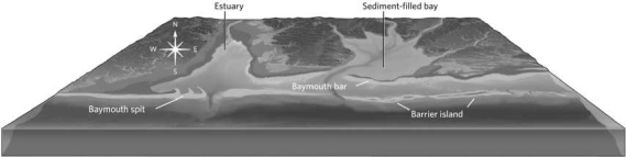
A)south
B)east
C)west
D)It is not possible to tell.
A)south
B)east
C)west
D)It is not possible to tell.
سؤال
سؤال
سؤال
سؤال
سؤال
سؤال
سؤال
Notice the newly constructed seawall in the illustration below. The MOST likely outcome of its construction is that the seawall will 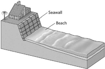
A)permanently protect the home from beach erosion.
B)increase sediment production on the beach, decreasing the rate of erosion.
C)deter biologic activity that might compromise the integrity of the cliff.
D)temporarily protect the cliff from beach erosion.
A)permanently protect the home from beach erosion.
B)increase sediment production on the beach, decreasing the rate of erosion.
C)deter biologic activity that might compromise the integrity of the cliff.
D)temporarily protect the cliff from beach erosion.
سؤال
سؤال
سؤال
سؤال
سؤال
سؤال
سؤال
سؤال
سؤال
سؤال
سؤال
سؤال
سؤال
سؤال
سؤال
سؤال
سؤال
سؤال
The picture below shows the fjords of Norway. This is an example of a(n) 
A)submergent coast.
B)accretionary coast.
C)estuary.
D)emergent coast.
A)submergent coast.
B)accretionary coast.
C)estuary.
D)emergent coast.
سؤال

فتح الحزمة
قم بالتسجيل لفتح البطاقات في هذه المجموعة!
Unlock Deck
Unlock Deck
1/60
العب
ملء الشاشة (f)
Deck 16: Marine Geology: the Study of Ocean Basins and Coasts
1
Passive continental margins
A)are characterized by broad continental shelves.
B)tend to be seismically active.
C)tend to be volcanically active.
D)are characterized by the presence of a deep-sea trench.
A)are characterized by broad continental shelves.
B)tend to be seismically active.
C)tend to be volcanically active.
D)are characterized by the presence of a deep-sea trench.
A
2
The timing and magnitude of tides in a given location is LEAST likely to be influenced by the
A)size of the waves.
B)ocean-basin shape.
C)moon's orbit.
D)shape of the shoreline.
A)size of the waves.
B)ocean-basin shape.
C)moon's orbit.
D)shape of the shoreline.
A
3
Coastal landforms are constantly changing because the
A)sand is constantly moving.
B)tides are getting stronger.
C)sand is moved by developers.
D)storms are getting stronger.
A)sand is constantly moving.
B)tides are getting stronger.
C)sand is moved by developers.
D)storms are getting stronger.
A
4
During a rising tide, the
A)coast is emergent.
B)coast is submergent.
C)shoreline moves seaward.
D)shoreline moves inland.
A)coast is emergent.
B)coast is submergent.
C)shoreline moves seaward.
D)shoreline moves inland.
فتح الحزمة
افتح القفل للوصول البطاقات البالغ عددها 60 في هذه المجموعة.
فتح الحزمة
k this deck
5
Building a dam across a river can lead to __________ because sediment becomes trapped behind the dam.
A)pollution
B)beach nourishment
C)reef bleaching
D)beach erosion
A)pollution
B)beach nourishment
C)reef bleaching
D)beach erosion
فتح الحزمة
افتح القفل للوصول البطاقات البالغ عددها 60 في هذه المجموعة.
فتح الحزمة
k this deck
6
Active continental margins
A)are characterized by narrow continental shelves.
B)are characterized by gradual continental slopes.
C)lack accretionary prisms.
D)are characterized by the presence of a spreading center immediately off shore.
A)are characterized by narrow continental shelves.
B)are characterized by gradual continental slopes.
C)lack accretionary prisms.
D)are characterized by the presence of a spreading center immediately off shore.
فتح الحزمة
افتح القفل للوصول البطاقات البالغ عددها 60 في هذه المجموعة.
فتح الحزمة
k this deck
7
The __________ is the generally twice-daily rise and fall of sea level.
A)wave
B)swash
C)tide
D)tidal bore
A)wave
B)swash
C)tide
D)tidal bore
فتح الحزمة
افتح القفل للوصول البطاقات البالغ عددها 60 في هذه المجموعة.
فتح الحزمة
k this deck
8
In the figure below, which letter represents the active continental margin?
A)A
B)B
C)C
D)D
A)A
B)B
C)C
D)D
فتح الحزمة
افتح القفل للوصول البطاقات البالغ عددها 60 في هذه المجموعة.
فتح الحزمة
k this deck
9
The production of tides is NOT affected by Earth's
A)gravitational attraction with the sun.
B)gravitational attraction with the moon.
C)gravitational interaction with Mars.
D)centrifugal force caused by the revolution of the Earth-Moon system.
A)gravitational attraction with the sun.
B)gravitational attraction with the moon.
C)gravitational interaction with Mars.
D)centrifugal force caused by the revolution of the Earth-Moon system.
فتح الحزمة
افتح القفل للوصول البطاقات البالغ عددها 60 في هذه المجموعة.
فتح الحزمة
k this deck
10
Which location on the figure below is the continental slope?
A)A
B)B
C)C
D)D
A)A
B)B
C)C
D)D
فتح الحزمة
افتح القفل للوصول البطاقات البالغ عددها 60 في هذه المجموعة.
فتح الحزمة
k this deck
11
Which location is the passive continental margin on the image below?
A)A
B)B
C)C
D)D
A)A
B)B
C)C
D)D
فتح الحزمة
افتح القفل للوصول البطاقات البالغ عددها 60 في هذه المجموعة.
فتح الحزمة
k this deck
12
Gently sloping fringes of sediment along the shore are known as
A)tidal flats.
B)beaches.
C)lagoons
D)inlets.
A)tidal flats.
B)beaches.
C)lagoons
D)inlets.
فتح الحزمة
افتح القفل للوصول البطاقات البالغ عددها 60 في هذه المجموعة.
فتح الحزمة
k this deck
13
Sea floor spreading is associated with
A)active continental margins.
B)passive continental margins.
C)mid-ocean ridges
D)abyssal plains.
A)active continental margins.
B)passive continental margins.
C)mid-ocean ridges
D)abyssal plains.
فتح الحزمة
افتح القفل للوصول البطاقات البالغ عددها 60 في هذه المجموعة.
فتح الحزمة
k this deck
14
The shape of the seafloor is called
A)topography.
B)bathymetry.
C)marine geology
D)oceanography.
A)topography.
B)bathymetry.
C)marine geology
D)oceanography.
فتح الحزمة
افتح القفل للوصول البطاقات البالغ عددها 60 في هذه المجموعة.
فتح الحزمة
k this deck
15
What is formed when layers of turbidites accumulate?
A)accretionary prisms
B)submarine canyons
C)continental margins
D)submarine fans
A)accretionary prisms
B)submarine canyons
C)continental margins
D)submarine fans
فتح الحزمة
افتح القفل للوصول البطاقات البالغ عددها 60 في هذه المجموعة.
فتح الحزمة
k this deck
16
The schematic shown below illustrates a(n)
A)emergent coast.
B)submergent coast.
C)active margin.
D)passive margin.
A)emergent coast.
B)submergent coast.
C)active margin.
D)passive margin.
فتح الحزمة
افتح القفل للوصول البطاقات البالغ عددها 60 في هذه المجموعة.
فتح الحزمة
k this deck
17
The active continental margin is located at the
A)west coast of North America.
B)east coast of North America.
C)west coast of Africa.
D)east coast of South America.
A)west coast of North America.
B)east coast of North America.
C)west coast of Africa.
D)east coast of South America.
فتح الحزمة
افتح القفل للوصول البطاقات البالغ عددها 60 في هذه المجموعة.
فتح الحزمة
k this deck
18
Subduction at convergent boundaries results in the formation of a
A)passive margin.
B)submarine canyon.
C)deep-sea trench.
D)well-developed beach.
A)passive margin.
B)submarine canyon.
C)deep-sea trench.
D)well-developed beach.
فتح الحزمة
افتح القفل للوصول البطاقات البالغ عددها 60 في هذه المجموعة.
فتح الحزمة
k this deck
19
The tide-generating force is a combination of the __________ and __________ .
A)gravitational attraction of the Moon; centrifugal force caused by the revolution of the Earth-Moon system
B)gravitational attraction of the Moon and the Sun; centrifugal force caused by the revolution of the Earth-Moon system
C)gravitational attraction of the Moon; the gravitational attraction of the Sun
D)centrifugal force caused by the revolution of the Earth-Moon system; the Coriolis effect
فتح الحزمة
افتح القفل للوصول البطاقات البالغ عددها 60 في هذه المجموعة.
فتح الحزمة
k this deck
20
When sea level rises and floods a glacially carved valley, the area is called a(n)
A)fjord.
B)wetland.
C)estuary.
D)reef.
A)fjord.
B)wetland.
C)estuary.
D)reef.
فتح الحزمة
افتح القفل للوصول البطاقات البالغ عددها 60 في هذه المجموعة.
فتح الحزمة
k this deck
21
In the figure below, which direction is the longshore drift?
A)south
B)east
C)west
D)It is not possible to tell.
A)south
B)east
C)west
D)It is not possible to tell.
فتح الحزمة
افتح القفل للوصول البطاقات البالغ عددها 60 في هذه المجموعة.
فتح الحزمة
k this deck
22
In the photograph below, notice how the waves are approaching the shore at an angle to the shoreline. This is an example of
A)wave refraction.
B)swash.
C)a breaker.
D)backwash.
A)wave refraction.
B)swash.
C)a breaker.
D)backwash.
فتح الحزمة
افتح القفل للوصول البطاقات البالغ عددها 60 في هذه المجموعة.
فتح الحزمة
k this deck
23
Many rocky coasts occur along active margins. This is because
A)active margins are associated with larger storms, which cause more erosion of sediment, leading to fewer beaches.
B)subduction along active margins consumes coastal sediments.
C)active margins often experience repeated uplift, and thus the waves have not had sufficient time to erode the land surface down to sea level.
D)active margins tend to have far fewer streams that feed sediment to the oceans; thus, there is not enough sand to create beaches.
فتح الحزمة
افتح القفل للوصول البطاقات البالغ عددها 60 في هذه المجموعة.
فتح الحزمة
k this deck
24
What will eventually happen to the headlands in the figure below?
A)They will join as the bays in between fill with sediment.
B)They will become a straight line of cliffs as rock is eroded away.
C)They will remain as they are for millions of years.
D)The sea will submerge them as the terrace is uplifted.
A)They will join as the bays in between fill with sediment.
B)They will become a straight line of cliffs as rock is eroded away.
C)They will remain as they are for millions of years.
D)The sea will submerge them as the terrace is uplifted.
فتح الحزمة
افتح القفل للوصول البطاقات البالغ عددها 60 في هذه المجموعة.
فتح الحزمة
k this deck
25
A coastline characterized by steep-sided cliffs and associated with an active margin is likely to be
A)accretionary.
B)submergent.
C)passive.
D)emergent.
A)accretionary.
B)submergent.
C)passive.
D)emergent.
فتح الحزمة
افتح القفل للوصول البطاقات البالغ عددها 60 في هذه المجموعة.
فتح الحزمة
k this deck
26
Which type of coastline would most likely contain estuaries or fjords?
A)subductive
B)emergent
C)submergent
D)divergent
A)subductive
B)emergent
C)submergent
D)divergent
فتح الحزمة
افتح القفل للوصول البطاقات البالغ عددها 60 في هذه المجموعة.
فتح الحزمة
k this deck
27
When the sea level rises, an ocean may invade a river valley, producing a nearshore body of water of mixed and variable salinity, which is termed a(n)
A)atoll.
B)lagoon.
C)estuary
D)jetty.
A)atoll.
B)lagoon.
C)estuary
D)jetty.
فتح الحزمة
افتح القفل للوصول البطاقات البالغ عددها 60 في هذه المجموعة.
فتح الحزمة
k this deck
28
A(n) __________ is a vegetated, flat-lying stretch of coast that floods at high tide, becomes particularly exposed at low tide, and does not feel the impact of strong waves.
A)marine terrace
B)coral reef
C)coastal wetland
D)estuary
A)marine terrace
B)coral reef
C)coastal wetland
D)estuary
فتح الحزمة
افتح القفل للوصول البطاقات البالغ عددها 60 في هذه المجموعة.
فتح الحزمة
k this deck
29
Barrier islands are constantly moving in the direction of
A)the longshore drift.
B)the high tide.
C)down welling.
D)the Coriolis effect.
A)the longshore drift.
B)the high tide.
C)down welling.
D)the Coriolis effect.
فتح الحزمة
افتح القفل للوصول البطاقات البالغ عددها 60 في هذه المجموعة.
فتح الحزمة
k this deck
30
The entire state of Florida is composed of fossiliferous limestone (indicative of a coral reef environment). This implies that in the recent past, Florida was
A)covered with caves.
B)a submergent coast.
C)an emergent coast.
D)in the mountains.
A)covered with caves.
B)a submergent coast.
C)an emergent coast.
D)in the mountains.
فتح الحزمة
افتح القفل للوصول البطاقات البالغ عددها 60 في هذه المجموعة.
فتح الحزمة
k this deck
31
Which of the following is the BEST example of an organic coast?
A)gently sloping, well-developed beach
B)wave-cut platform
C)shoreline that has just received beach nourishment
D)shallow coral reef
A)gently sloping, well-developed beach
B)wave-cut platform
C)shoreline that has just received beach nourishment
D)shallow coral reef
فتح الحزمة
افتح القفل للوصول البطاقات البالغ عددها 60 في هذه المجموعة.
فتح الحزمة
k this deck
32
If sea level continues to rise and covers the city of Miami, the Florida coast will become a(n)
A)emergent coast.
B)submergent coast.
C)continental slope.
D)abyssal plain.
A)emergent coast.
B)submergent coast.
C)continental slope.
D)abyssal plain.
فتح الحزمة
افتح القفل للوصول البطاقات البالغ عددها 60 في هذه المجموعة.
فتح الحزمة
k this deck
33
A coral reef would MOST likely be found
A)in an expansive, warm-water tropical tidal flat.
B)in clear, shallow waters at high latitudes.
C)in the shallow waters surrounding a volcanic tropical island.
D)along the coasts of active margins.
A)in an expansive, warm-water tropical tidal flat.
B)in clear, shallow waters at high latitudes.
C)in the shallow waters surrounding a volcanic tropical island.
D)along the coasts of active margins.
فتح الحزمة
افتح القفل للوصول البطاقات البالغ عددها 60 في هذه المجموعة.
فتح الحزمة
k this deck
34
In the figure below, which direction is the longshore current?
A)south
B)east
C)west
D)It is not possible to tell.
A)south
B)east
C)west
D)It is not possible to tell.
فتح الحزمة
افتح القفل للوصول البطاقات البالغ عددها 60 في هذه المجموعة.
فتح الحزمة
k this deck
35
Along beaches, groins have
A)solved the problem of beach drift.
B)increased erosion rates immediately up current from the groin.
C)increased erosion rates immediately down current from the groin.
D)increased depositional rates immediately down current from the groin.
A)solved the problem of beach drift.
B)increased erosion rates immediately up current from the groin.
C)increased erosion rates immediately down current from the groin.
D)increased depositional rates immediately down current from the groin.
فتح الحزمة
افتح القفل للوصول البطاقات البالغ عددها 60 في هذه المجموعة.
فتح الحزمة
k this deck
36
The balance between sediment supplied and sediment removed on a beach is known as
A)sediment budget.
B)wave erosion.
C)wave refraction.
D)longshore drift.
A)sediment budget.
B)wave erosion.
C)wave refraction.
D)longshore drift.
فتح الحزمة
افتح القفل للوصول البطاقات البالغ عددها 60 في هذه المجموعة.
فتح الحزمة
k this deck
37
Sea level is currently rising at 3.2 mm/yr, and scientists predict that global warming could cause a rise in sea level of 7 m if left unabated. How long will it take the sea to rise 7 m at the current rate?
A)2,121 years
B)0.0004 year
C)2.121 years
D)0.47 year
A)2,121 years
B)0.0004 year
C)2.121 years
D)0.47 year
فتح الحزمة
افتح القفل للوصول البطاقات البالغ عددها 60 في هذه المجموعة.
فتح الحزمة
k this deck
38
Which of the following features is characteristic of a rocky coast?
A)sand spits
B)sea stacks
C)lagoons
D)accretionary prisms
A)sand spits
B)sea stacks
C)lagoons
D)accretionary prisms
فتح الحزمة
افتح القفل للوصول البطاقات البالغ عددها 60 في هذه المجموعة.
فتح الحزمة
k this deck
39
Which of the following scenarios is most likely to result in an emergent coast?
A)global sea level rise
B)uplift associated with active margin tectonics
C)subsidence of the shoreline caused by near-shore removal of groundwater
D)the formation of a near-shore coral reef
A)global sea level rise
B)uplift associated with active margin tectonics
C)subsidence of the shoreline caused by near-shore removal of groundwater
D)the formation of a near-shore coral reef
فتح الحزمة
افتح القفل للوصول البطاقات البالغ عددها 60 في هذه المجموعة.
فتح الحزمة
k this deck
40
A coast that grows seaward as a result of regular sedimentation is a(n)
A)active continental margin.
B)erosional coast.
C)accretionary coast.
D)coastal plain.
A)active continental margin.
B)erosional coast.
C)accretionary coast.
D)coastal plain.
فتح الحزمة
افتح القفل للوصول البطاقات البالغ عددها 60 في هذه المجموعة.
فتح الحزمة
k this deck
41
Notice the newly constructed seawall in the illustration below. The MOST likely outcome of its construction is that the seawall will
A)permanently protect the home from beach erosion.
B)increase sediment production on the beach, decreasing the rate of erosion.
C)deter biologic activity that might compromise the integrity of the cliff.
D)temporarily protect the cliff from beach erosion.
A)permanently protect the home from beach erosion.
B)increase sediment production on the beach, decreasing the rate of erosion.
C)deter biologic activity that might compromise the integrity of the cliff.
D)temporarily protect the cliff from beach erosion.
فتح الحزمة
افتح القفل للوصول البطاقات البالغ عددها 60 في هذه المجموعة.
فتح الحزمة
k this deck
42
Contrast emergent and submergent coasts. List at least two reasons why coasts may become emergent or submergent.
فتح الحزمة
افتح القفل للوصول البطاقات البالغ عددها 60 في هذه المجموعة.
فتح الحزمة
k this deck
43
Some beaches are maintained by artificially increasing the rate of sediment supply using a procedure known as
A)beach protection.
B)sand swash.
C)beach nourishment
D)tidal bore.
A)beach protection.
B)sand swash.
C)beach nourishment
D)tidal bore.
فتح الحزمة
افتح القفل للوصول البطاقات البالغ عددها 60 في هذه المجموعة.
فتح الحزمة
k this deck
44
The width of the intertidal zone depends on the tidal
A)reach.
B)bore.
C)reach and the slope of the seafloor surface.
D)bore and the slope of the seafloor surface.
A)reach.
B)bore.
C)reach and the slope of the seafloor surface.
D)bore and the slope of the seafloor surface.
فتح الحزمة
افتح القفل للوصول البطاقات البالغ عددها 60 في هذه المجموعة.
فتح الحزمة
k this deck
45
Why is it NOT a good idea to build on barrier islands?
فتح الحزمة
افتح القفل للوصول البطاقات البالغ عددها 60 في هذه المجموعة.
فتح الحزمة
k this deck
46
Which of the following is MOST true of beach nourishment as a solution to coastal erosion?
A)It is a permanent solution that will protect an erosional beach.
B)The flux of sediment from beach nourishment will change a beach from erosional to accretionary.
C)It is a temporary, but inexpensive, solution to coastal erosion.
D)It is costly and may only provide a temporary solution.
A)It is a permanent solution that will protect an erosional beach.
B)The flux of sediment from beach nourishment will change a beach from erosional to accretionary.
C)It is a temporary, but inexpensive, solution to coastal erosion.
D)It is costly and may only provide a temporary solution.
فتح الحزمة
افتح القفل للوصول البطاقات البالغ عددها 60 في هذه المجموعة.
فتح الحزمة
k this deck
47
What is a longshore drift? Why does this take place? Illustrate this phenomenon.
فتح الحزمة
افتح القفل للوصول البطاقات البالغ عددها 60 في هذه المجموعة.
فتح الحزمة
k this deck
48
How is an erosional coast different from an accretionary coast?
فتح الحزمة
افتح القفل للوصول البطاقات البالغ عددها 60 في هذه المجموعة.
فتح الحزمة
k this deck
49
Which of the following is LEAST likely to result in reef bleaching?
A)pollution
B)changes in seawater salinity
C)changes in water temperature
D)gradual sea level rise
A)pollution
B)changes in seawater salinity
C)changes in water temperature
D)gradual sea level rise
فتح الحزمة
افتح القفل للوصول البطاقات البالغ عددها 60 في هذه المجموعة.
فتح الحزمة
k this deck
50
Compare and contrast an active continental margin and a passive continental margin.
فتح الحزمة
افتح القفل للوصول البطاقات البالغ عددها 60 في هذه المجموعة.
فتح الحزمة
k this deck
51
If the Earth's solid surface were smooth and completely submerged beneath the ocean, each location would experience two tides a day and the tidal reach would depend on the position of the location relative to the highest part of the bulge. This is not the case. Describe three factors, aside from the tide-generating force, that affect the timing and magnitude of tides.
فتح الحزمة
افتح القفل للوصول البطاقات البالغ عددها 60 في هذه المجموعة.
فتح الحزمة
k this deck
52
The difference between sea level at high tide and low tide for a given location is known as
A)tidal reach.
B)swash.
C)continental shelf.
D)tidal bore.
A)tidal reach.
B)swash.
C)continental shelf.
D)tidal bore.
فتح الحزمة
افتح القفل للوصول البطاقات البالغ عددها 60 في هذه المجموعة.
فتح الحزمة
k this deck
53
What are estuaries and how do they form?
فتح الحزمة
افتح القفل للوصول البطاقات البالغ عددها 60 في هذه المجموعة.
فتح الحزمة
k this deck
54
All three types of plate boundaries can be seen by studying the bathymetry of the ocean floor. How is this so?
فتح الحزمة
افتح القفل للوصول البطاقات البالغ عددها 60 في هذه المجموعة.
فتح الحزمة
k this deck
55
Describe one way humans have tried to mitigate beach erosion. Was it ultimately successful in both the short term and long term?
فتح الحزمة
افتح القفل للوصول البطاقات البالغ عددها 60 في هذه المجموعة.
فتح الحزمة
k this deck
56
Structures-like jetties, groins, and breakwaters-that are designed to prevent beach erosion
A)are permanent solutions that protect erosional beaches.
B)must be built in conjunction with beach nourishment.
C)are a temporary solution that decreases the rate of beach erosion.
D)have the added benefit of allowing organic coasts to develop.
A)are permanent solutions that protect erosional beaches.
B)must be built in conjunction with beach nourishment.
C)are a temporary solution that decreases the rate of beach erosion.
D)have the added benefit of allowing organic coasts to develop.
فتح الحزمة
افتح القفل للوصول البطاقات البالغ عددها 60 في هذه المجموعة.
فتح الحزمة
k this deck
57
Swamps and marshes are examples of
A)estuaries.
B)coastal wetlands.
C)fjords.
D)swashes
A)estuaries.
B)coastal wetlands.
C)fjords.
D)swashes
فتح الحزمة
افتح القفل للوصول البطاقات البالغ عددها 60 في هذه المجموعة.
فتح الحزمة
k this deck
58
The process of reef bleaching occurs when
A)reefs lose their color and die in response to the warming of seawater.
B)reefs lose their color following large storms.
C)reefs are exposed to too much sunlight.
D)over fishing causes a decrease in species diversity.
A)reefs lose their color and die in response to the warming of seawater.
B)reefs lose their color following large storms.
C)reefs are exposed to too much sunlight.
D)over fishing causes a decrease in species diversity.
فتح الحزمة
افتح القفل للوصول البطاقات البالغ عددها 60 في هذه المجموعة.
فتح الحزمة
k this deck
59
The picture below shows the fjords of Norway. This is an example of a(n)
A)submergent coast.
B)accretionary coast.
C)estuary.
D)emergent coast.
A)submergent coast.
B)accretionary coast.
C)estuary.
D)emergent coast.
فتح الحزمة
افتح القفل للوصول البطاقات البالغ عددها 60 في هذه المجموعة.
فتح الحزمة
k this deck
60
Why do tides occur? What is the driving force, and what factors contribute to this force?
فتح الحزمة
افتح القفل للوصول البطاقات البالغ عددها 60 في هذه المجموعة.
فتح الحزمة
k this deck
فتح الحزمة
افتح القفل للوصول البطاقات البالغ عددها 60 في هذه المجموعة.


