Deck 3: Landscapes Fashioned by Water
ملء الشاشة (f)
سؤال
سؤال
سؤال
سؤال
سؤال
سؤال
سؤال
سؤال
سؤال
سؤال

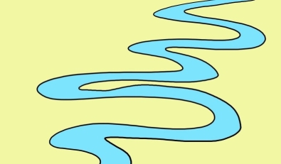
Examine the sketch of a bend in a river. The arrows show the water flow direction. In which of the four lettered locations will the water be moving at the highest velocity?
A)A
B)B
C)C
D)D
سؤال
سؤال
سؤال
سؤال
سؤال
سؤال
سؤال
سؤال
سؤال
سؤال
سؤال
سؤال
سؤال
سؤال
سؤال
سؤال
سؤال
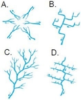
Which of the drainage patterns shown here might develop on relatively uniform surface materials?
A)A
B)B
C)C
D)D
سؤال
سؤال

Examine the sketch of a bend in a river. The arrows show the water flow direction. In which of the four lettered locations is deposition most likely to occur?
A)A
B)B
C)C
D)D
سؤال
سؤال
سؤال
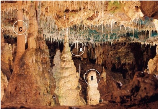
The feature marked "B" on this photo of a cavern interior is a stalactite.
سؤال
سؤال
Examine the sketch of a bend in a river. The arrows show the water flow direction. In which of the four lettered locations will erosion take place?
A)A
B)B
C)C
D)D
سؤال
سؤال
سؤال
سؤال
سؤال
سؤال
سؤال
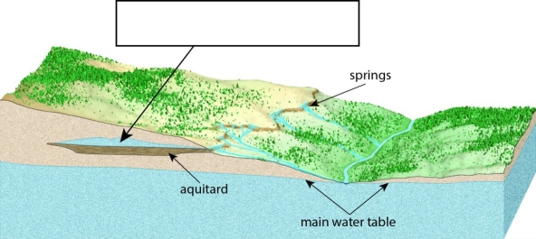
A(n)________ forms atop an aquitard as shown in this image.
سؤال
سؤال
سؤال

The river depicted in this drawing shows prominent ________.
سؤال
سؤال
سؤال
سؤال
سؤال
سؤال
سؤال
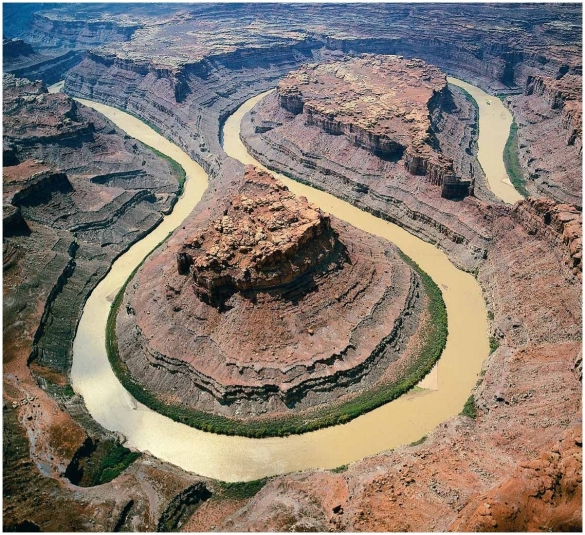
Is this river likely to have a bedrock channel or alluvial channel?
سؤال
سؤال
سؤال
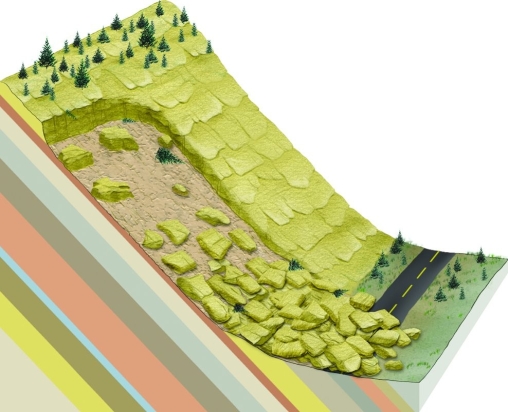
What is the specific form of mass wasting illustrated here?
سؤال
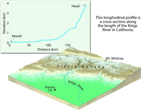
Examine this figure. Based on it, the Kings River has a steeper ________ near its head and a gentler ________ (same word)near its mouth.
سؤال
سؤال
سؤال
سؤال
سؤال
سؤال
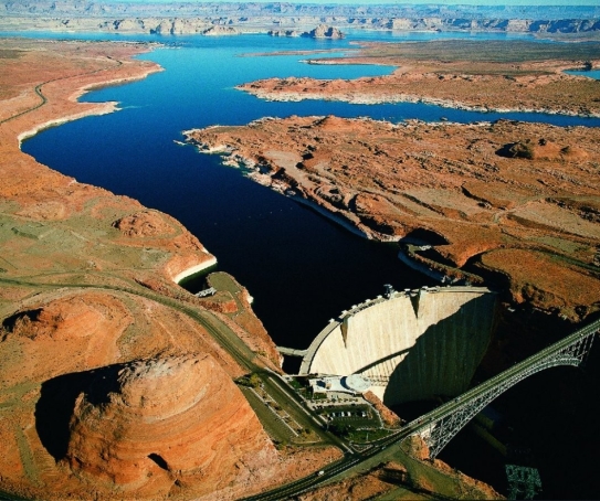
Examine the photo of Glen Canyon Dam in Arizona and the reservoir called "Lake Powell" that formed upstream of it. Describe what has happened to base level on the Colorado River at this location since the dam was constructed. Make a prediction for what will happen at this location over the next several hundred years.
سؤال
سؤال
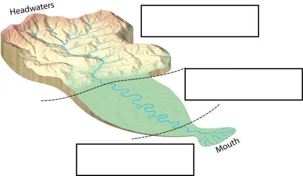
Label each of the three zones (as defined by the dominant activity there)of the river shown in the figure.
سؤال
سؤال
سؤال
Examine this photograph. Identify the features seen here, and describe in detail the sequence of events which must have occurred in order to produce these features.
سؤال
Match between columns

فتح الحزمة
قم بالتسجيل لفتح البطاقات في هذه المجموعة!
Unlock Deck
Unlock Deck
1/67
العب
ملء الشاشة (f)
Deck 3: Landscapes Fashioned by Water
1
________ is the maximum load of solid particles a stream can transport in a unit of time.
A)Capacity
B)Competence
C)Alluvium
D)Bed load
A)Capacity
B)Competence
C)Alluvium
D)Bed load
A
2
Which of the following is not a form of mass wasting?
A)debris flow
B)slump
C)rockslide
D)transpiration
A)debris flow
B)slump
C)rockslide
D)transpiration
D
3
Sediment in a stream is transported as part of the ________.
A)dissolved load
B)suspended load
C)bed load
D)all of the above
A)dissolved load
B)suspended load
C)bed load
D)all of the above
D
4
Between a river and its floodplain, you might find ________.
A)natural levees
B)deltas
C)distributaries
D)meanders
A)natural levees
B)deltas
C)distributaries
D)meanders
فتح الحزمة
افتح القفل للوصول البطاقات البالغ عددها 67 في هذه المجموعة.
فتح الحزمة
k this deck
5
One drainage basin is separated from a neighboring drainage basin by a ________.
A)divide
B)slope
C)rill
D)the zone of deposition
A)divide
B)slope
C)rill
D)the zone of deposition
فتح الحزمة
افتح القفل للوصول البطاقات البالغ عددها 67 في هذه المجموعة.
فتح الحزمة
k this deck
6
Precipitation of water on the land surface leads directly to ________.
A)infiltration
B)evaporation
C)runoff
D)all of the above
A)infiltration
B)evaporation
C)runoff
D)all of the above
فتح الحزمة
افتح القفل للوصول البطاقات البالغ عددها 67 في هذه المجموعة.
فتح الحزمة
k this deck
7
The downslope movement of rock or soil due to the influence of gravity is ________.
A)weathering
B)erosion
C)mass wasting
D)exfoliation
A)weathering
B)erosion
C)mass wasting
D)exfoliation
فتح الحزمة
افتح القفل للوصول البطاقات البالغ عددها 67 في هذه المجموعة.
فتح الحزمة
k this deck
8
How do potholes form?
A)mass wasting on steep slopes
B)pebbles caught in swirling eddies of water
C)sorting of alluvium
D)when competence suddenly decreases along a river
A)mass wasting on steep slopes
B)pebbles caught in swirling eddies of water
C)sorting of alluvium
D)when competence suddenly decreases along a river
فتح الحزمة
افتح القفل للوصول البطاقات البالغ عددها 67 في هذه المجموعة.
فتح الحزمة
k this deck
9
Ranked by discharge, what is the world's largest river?
A)Mississippi
B)Yellowstone
C)Nile
D)Amazon
A)Mississippi
B)Yellowstone
C)Nile
D)Amazon
فتح الحزمة
افتح القفل للوصول البطاقات البالغ عددها 67 في هذه المجموعة.
فتح الحزمة
k this deck
10
Examine the sketch of a bend in a river. The arrows show the water flow direction. In which of the four lettered locations will the water be moving at the highest velocity?
A)A
B)B
C)C
D)D
فتح الحزمة
افتح القفل للوصول البطاقات البالغ عددها 67 في هذه المجموعة.
فتح الحزمة
k this deck
11
If you were to examine the longitudinal profile of a typical river, you would probably find that the gradient is ________.
A)steepest near the mouth
B)steepest near the headwaters
C)roughly the same at the mouth and the headwaters
D)steepest in the zone of transport
A)steepest near the mouth
B)steepest near the headwaters
C)roughly the same at the mouth and the headwaters
D)steepest in the zone of transport
فتح الحزمة
افتح القفل للوصول البطاقات البالغ عددها 67 في هذه المجموعة.
فتح الحزمة
k this deck
12
What kind of drainage pattern would develop on the slopes of Mount Rainier, an isolated volcano in Washington state?
A)dendritic
B)radial
C)rectangular
D)trellis
A)dendritic
B)radial
C)rectangular
D)trellis
فتح الحزمة
افتح القفل للوصول البطاقات البالغ عددها 67 في هذه المجموعة.
فتح الحزمة
k this deck
13
The continuous side-to-side erosion caused by shifting of the stream's meanders produces an increasingly broader, flat valley floor covered with alluvium. The flat part of this valley floor, next to the stream, is the ________.
A)incised meander
B)delta
C)floodplain
D)headwaters
A)incised meander
B)delta
C)floodplain
D)headwaters
فتح الحزمة
افتح القفل للوصول البطاقات البالغ عددها 67 في هذه المجموعة.
فتح الحزمة
k this deck
14
At a delta, which of the following happens?
A)Tributary channels merge into a single large channel.
B)The main channel splits into a number of distributary channels.
C)The gradient becomes noticeably steeper.
D)The stream tends to erode sediment.
A)Tributary channels merge into a single large channel.
B)The main channel splits into a number of distributary channels.
C)The gradient becomes noticeably steeper.
D)The stream tends to erode sediment.
فتح الحزمة
افتح القفل للوصول البطاقات البالغ عددها 67 في هذه المجموعة.
فتح الحزمة
k this deck
15
________ make up the suspended loads of most rivers and streams.
A)Dissolved ions such as calcium and sodium
B)Silt and clay-sized detrital grains
C)Sand and gravel that move along the bottom during floods
D)Point bars
A)Dissolved ions such as calcium and sodium
B)Silt and clay-sized detrital grains
C)Sand and gravel that move along the bottom during floods
D)Point bars
فتح الحزمة
افتح القفل للوصول البطاقات البالغ عددها 67 في هذه المجموعة.
فتح الحزمة
k this deck
16
External processes that occur at or near Earth's surface and are powered by ________.
A)radioactive elements in Earth's mantle
B)the Sun
C)geothermal heat
D)cosmic rays
A)radioactive elements in Earth's mantle
B)the Sun
C)geothermal heat
D)cosmic rays
فتح الحزمة
افتح القفل للوصول البطاقات البالغ عددها 67 في هذه المجموعة.
فتح الحزمة
k this deck
17
If discharge of a stream increases to the point that the stream overflows its banks, the stream is said to be ________.
A)a yazoo tributary
B)flooding
C)approaching base level
D)eroding a pothole
A)a yazoo tributary
B)flooding
C)approaching base level
D)eroding a pothole
فتح الحزمة
افتح القفل للوصول البطاقات البالغ عددها 67 في هذه المجموعة.
فتح الحزمة
k this deck
18
Plants consume water during photosynthesis. They also release it to the atmosphere during ________.
A)evaporation
B)degassing
C)transpiration
D)infiltration
A)evaporation
B)degassing
C)transpiration
D)infiltration
فتح الحزمة
افتح القفل للوصول البطاقات البالغ عددها 67 في هذه المجموعة.
فتح الحزمة
k this deck
19
Rapids and waterfalls are more likely in ________.
A)a V-shaped valley
B)a meandering stream
C)a braided stream
D)a delta
A)a V-shaped valley
B)a meandering stream
C)a braided stream
D)a delta
فتح الحزمة
افتح القفل للوصول البطاقات البالغ عددها 67 في هذه المجموعة.
فتح الحزمة
k this deck
20
Streams erode downward until they reach ________.
A)their base level
B)their profile
C)an oxbow
D)the floodplain
A)their base level
B)their profile
C)an oxbow
D)the floodplain
فتح الحزمة
افتح القفل للوصول البطاقات البالغ عددها 67 في هذه المجموعة.
فتح الحزمة
k this deck
21
Groundwater tends to flow through bodies of rock or sediment that ________.
A)are composed of dark silicate minerals
B)have a high porosity
C)have a high permeability
D)are aquitards
A)are composed of dark silicate minerals
B)have a high porosity
C)have a high permeability
D)are aquitards
فتح الحزمة
افتح القفل للوصول البطاقات البالغ عددها 67 في هذه المجموعة.
فتح الحزمة
k this deck
22
Gravity plays an important role in all mass wasting events.
فتح الحزمة
افتح القفل للوصول البطاقات البالغ عددها 67 في هذه المجموعة.
فتح الحزمة
k this deck
23
Mass wasting processes are always rapid.
فتح الحزمة
افتح القفل للوصول البطاقات البالغ عددها 67 في هذه المجموعة.
فتح الحزمة
k this deck
24
Loose, granular particles assume a stable slope called the angle of repose.
فتح الحزمة
افتح القفل للوصول البطاقات البالغ عددها 67 في هذه المجموعة.
فتح الحزمة
k this deck
25
Leaking septic tanks and agricultural fertilizers are both potential sources of groundwater contamination.
فتح الحزمة
افتح القفل للوصول البطاقات البالغ عددها 67 في هذه المجموعة.
فتح الحزمة
k this deck
26
A narrow, V-shaped river valley is likely to be more well-developed than a broad valley with a prominent floodplain.
فتح الحزمة
افتح القفل للوصول البطاقات البالغ عددها 67 في هذه المجموعة.
فتح الحزمة
k this deck
27
Which of the drainage patterns shown here might develop on relatively uniform surface materials?
A)A
B)B
C)C
D)D
فتح الحزمة
افتح القفل للوصول البطاقات البالغ عددها 67 في هذه المجموعة.
فتح الحزمة
k this deck
28
Caves are formed by groundwater in granite and basalt.
فتح الحزمة
افتح القفل للوصول البطاقات البالغ عددها 67 في هذه المجموعة.
فتح الحزمة
k this deck
29
Examine the sketch of a bend in a river. The arrows show the water flow direction. In which of the four lettered locations is deposition most likely to occur?
A)A
B)B
C)C
D)D
فتح الحزمة
افتح القفل للوصول البطاقات البالغ عددها 67 في هذه المجموعة.
فتح الحزمة
k this deck
30
The Grand Canyon was carved entirely by the Colorado River.
فتح الحزمة
افتح القفل للوصول البطاقات البالغ عددها 67 في هذه المجموعة.
فتح الحزمة
k this deck
31
Groundwater is the largest reservoir of ________.
A)water on Earth
B)seawater on Earth
C)glacial ice on Earth
D)freshwater that is readily available to humans
A)water on Earth
B)seawater on Earth
C)glacial ice on Earth
D)freshwater that is readily available to humans
فتح الحزمة
افتح القفل للوصول البطاقات البالغ عددها 67 في هذه المجموعة.
فتح الحزمة
k this deck
32
The feature marked "B" on this photo of a cavern interior is a stalactite.
فتح الحزمة
افتح القفل للوصول البطاقات البالغ عددها 67 في هذه المجموعة.
فتح الحزمة
k this deck
33
Infiltration adds water to ________.
A)the groundwater
B)runoff (streams)
C)the atmosphere
D)base level
A)the groundwater
B)runoff (streams)
C)the atmosphere
D)base level
فتح الحزمة
افتح القفل للوصول البطاقات البالغ عددها 67 في هذه المجموعة.
فتح الحزمة
k this deck
34
Examine the sketch of a bend in a river. The arrows show the water flow direction. In which of the four lettered locations will erosion take place?
A)A
B)B
C)C
D)D
فتح الحزمة
افتح القفل للوصول البطاقات البالغ عددها 67 في هذه المجموعة.
فتح الحزمة
k this deck
35
Where the water table intersects Earth's surface, a(n)________ results.
A)geyser
B)spring
C)artesian well
D)cone of depression
A)geyser
B)spring
C)artesian well
D)cone of depression
فتح الحزمة
افتح القفل للوصول البطاقات البالغ عددها 67 في هذه المجموعة.
فتح الحزمة
k this deck
36
In parts of the High Plains aquifer, water is being pumped from the ground faster than it is replenished. This has resulted in the water table dropping significantly.
فتح الحزمة
افتح القفل للوصول البطاقات البالغ عددها 67 في هذه المجموعة.
فتح الحزمة
k this deck
37
Artesian wells may be nonflowing.
فتح الحزمة
افتح القفل للوصول البطاقات البالغ عددها 67 في هذه المجموعة.
فتح الحزمة
k this deck
38
Groundwater may be ________.
A)extracted in such high quantities that the soil packs together and reduces pore space, resulting in subsidence of the land surface
B)contaminated
C)pumped out faster than natural processes can replenish it
D)all of the above
A)extracted in such high quantities that the soil packs together and reduces pore space, resulting in subsidence of the land surface
B)contaminated
C)pumped out faster than natural processes can replenish it
D)all of the above
فتح الحزمة
افتح القفل للوصول البطاقات البالغ عددها 67 في هذه المجموعة.
فتح الحزمة
k this deck
39
Groundwater can be a source of surface runoff.
فتح الحزمة
افتح القفل للوصول البطاقات البالغ عددها 67 في هذه المجموعة.
فتح الحزمة
k this deck
40
The drainage pattern that would develop on highly fractured bedrock would likely be rectangular.
فتح الحزمة
افتح القفل للوصول البطاقات البالغ عددها 67 في هذه المجموعة.
فتح الحزمة
k this deck
41
A(n)________ forms atop an aquitard as shown in this image.
فتح الحزمة
افتح القفل للوصول البطاقات البالغ عددها 67 في هذه المجموعة.
فتح الحزمة
k this deck
42
The maze of steep-sided limestone hills in the Guilin District of southern China is a celebrated example of ________.
فتح الحزمة
افتح القفل للوصول البطاقات البالغ عددها 67 في هذه المجموعة.
فتح الحزمة
k this deck
43
________ are formed when groundwater dissolves cavities into limestone.
فتح الحزمة
افتح القفل للوصول البطاقات البالغ عددها 67 في هذه المجموعة.
فتح الحزمة
k this deck
44
The river depicted in this drawing shows prominent ________.
فتح الحزمة
افتح القفل للوصول البطاقات البالغ عددها 67 في هذه المجموعة.
فتح الحزمة
k this deck
45
________ is located in tiny pore spaces between grains of soil and sediment, underground.
فتح الحزمة
افتح القفل للوصول البطاقات البالغ عددها 67 في هذه المجموعة.
فتح الحزمة
k this deck
46
Sinkholes form when the roof of a cavern collapses.
فتح الحزمة
افتح القفل للوصول البطاقات البالغ عددها 67 في هذه المجموعة.
فتح الحزمة
k this deck
47
Building a dam on a stream raises its ________, causing it to cease erosion and begin to deposit sediment.
فتح الحزمة
افتح القفل للوصول البطاقات البالغ عددها 67 في هذه المجموعة.
فتح الحزمة
k this deck
48
Drawdown of groundwater due to heavy pumping from a well may result in a(n)________, a "dimple" in the water table.
فتح الحزمة
افتح القفل للوصول البطاقات البالغ عددها 67 في هذه المجموعة.
فتح الحزمة
k this deck
49
________ floods are limited in area, occur with little warning, and are most common with intense rainfall events in areas of impervious surface conditions or steep topography.
فتح الحزمة
افتح القفل للوصول البطاقات البالغ عددها 67 في هذه المجموعة.
فتح الحزمة
k this deck
50
Old Faithful, a(n)________ in Yellowstone National Park, erupts steam and hot water.
فتح الحزمة
افتح القفل للوصول البطاقات البالغ عددها 67 في هذه المجموعة.
فتح الحزمة
k this deck
51
Is this river likely to have a bedrock channel or alluvial channel?
فتح الحزمة
افتح القفل للوصول البطاقات البالغ عددها 67 في هذه المجموعة.
فتح الحزمة
k this deck
52
External processes include weathering, mass wasting, and ________.
فتح الحزمة
افتح القفل للوصول البطاقات البالغ عددها 67 في هذه المجموعة.
فتح الحزمة
k this deck
53
Laminar flow is characterized by swirling eddies of water motion.
فتح الحزمة
افتح القفل للوصول البطاقات البالغ عددها 67 في هذه المجموعة.
فتح الحزمة
k this deck
54
What is the specific form of mass wasting illustrated here?
فتح الحزمة
افتح القفل للوصول البطاقات البالغ عددها 67 في هذه المجموعة.
فتح الحزمة
k this deck
55
Examine this figure. Based on it, the Kings River has a steeper ________ near its head and a gentler ________ (same word)near its mouth.
فتح الحزمة
افتح القفل للوصول البطاقات البالغ عددها 67 في هذه المجموعة.
فتح الحزمة
k this deck
56
Match the items in the first column with the correct descriptions in the second column.
A)a complex network of converging and diverging channels that thread their way among numerous islands or gravel bars.
B)the process by which solid particles of various sizes are separated and deposited in different locations.
C)the volume of water flowing past a certain point in a given unit of time.
D)the physical removal of material by a mobile agent such as flowing water, waves, wind, or ice.
E)sand, gravel, and large boulders that are too large to be carried in suspension, and instead move along the bottom of a stream channel.
F)the physical breakdown (disintegration)and chemical alteration (decomposition)of rock at or near Earth's surface.
G)the slope of a stream channel expressed as the vertical drop of a stream over a specified distance.
H)the transfer of rock and soil downslope, under the influence of gravity.
1)Weathering
2)Discharge
3)Bed load
4)Mass wasting
5)Erosion
6)Sorting
7)Gradient
8)Braided channels
فتح الحزمة
افتح القفل للوصول البطاقات البالغ عددها 67 في هذه المجموعة.
فتح الحزمة
k this deck
57
________ is a measure of the volume of open space in rocks and unconsolidated, geological materials like alluvium and soils.
فتح الحزمة
افتح القفل للوصول البطاقات البالغ عددها 67 في هذه المجموعة.
فتح الحزمة
k this deck
58
The steepest angle at which unconsolidated, granular material remains stable is ________.
فتح الحزمة
افتح القفل للوصول البطاقات البالغ عددها 67 في هذه المجموعة.
فتح الحزمة
k this deck
59
________ can form when the pressure surface is above the land surface.
فتح الحزمة
افتح القفل للوصول البطاقات البالغ عددها 67 في هذه المجموعة.
فتح الحزمة
k this deck
60
A hot spring is a kind of geyser.
فتح الحزمة
افتح القفل للوصول البطاقات البالغ عددها 67 في هذه المجموعة.
فتح الحزمة
k this deck
61
Examine the photo of Glen Canyon Dam in Arizona and the reservoir called "Lake Powell" that formed upstream of it. Describe what has happened to base level on the Colorado River at this location since the dam was constructed. Make a prediction for what will happen at this location over the next several hundred years.
فتح الحزمة
افتح القفل للوصول البطاقات البالغ عددها 67 في هذه المجموعة.
فتح الحزمة
k this deck
62
Imagine you are an astronaut, landing on an alien world. Looking out your spacecraft window, you see a world that looks very much like Earth. You notice a disappearing stream and two sinkholes. Based on your training in Earth science, make a prediction about the rock type you would find in the area where you have landed, and justify your prediction. Make a second prediction about the composition of the atmosphere on the new planet.
فتح الحزمة
افتح القفل للوصول البطاقات البالغ عددها 67 في هذه المجموعة.
فتح الحزمة
k this deck
63
Label each of the three zones (as defined by the dominant activity there)of the river shown in the figure.
فتح الحزمة
افتح القفل للوصول البطاقات البالغ عددها 67 في هذه المجموعة.
فتح الحزمة
k this deck
64
Describe three factors that can act as triggers for mass wasting events.
فتح الحزمة
افتح القفل للوصول البطاقات البالغ عددها 67 في هذه المجموعة.
فتح الحزمة
k this deck
65
In Pearson County, residents are concerned because the water table has been dropping for more than two years. What might be some of the reasons that the amount of groundwater in Pearson County is decreasing?
فتح الحزمة
افتح القفل للوصول البطاقات البالغ عددها 67 في هذه المجموعة.
فتح الحزمة
k this deck
66
Examine this photograph. Identify the features seen here, and describe in detail the sequence of events which must have occurred in order to produce these features.
فتح الحزمة
افتح القفل للوصول البطاقات البالغ عددها 67 في هذه المجموعة.
فتح الحزمة
k this deck
68
Match between columns
فتح الحزمة
افتح القفل للوصول البطاقات البالغ عددها 67 في هذه المجموعة.
فتح الحزمة
k this deck
فتح الحزمة
افتح القفل للوصول البطاقات البالغ عددها 67 في هذه المجموعة.


