Deck 15: World Climates
ملء الشاشة (f)
سؤال
سؤال
سؤال
سؤال
سؤال
(A) (B)
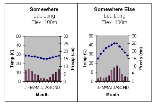
Of the two climate diagrams shown above,the one that most likely represents a Southern Hemisphere location is:
A)Diagram A only.
B)Diagram B only.
C)both Diagram A and Diagram B
D)neither Diagram A nor Diagram B.
سؤال
سؤال
سؤال
سؤال
سؤال
سؤال
سؤال
(A) (B)
Regarding the latitude of the two locations represented on the climate diagrams above,what can be said?
A)The location of Diagram A is probably at a lower latitude than the location of Diagram B.
B)The location of Diagram A is probably at a higher latitude than the location of Diagram B.
C)The two locations are probably at a similar latitude.
D)There is not enough information to speculate about the latitude of these locations.
سؤال
سؤال
سؤال
سؤال
سؤال
سؤال
سؤال
سؤال
سؤال
سؤال
سؤال
سؤال
سؤال
سؤال
سؤال
سؤال
سؤال
سؤال
سؤال
سؤال
سؤال
سؤال
سؤال
سؤال
سؤال
سؤال
سؤال
سؤال
سؤال
سؤال
سؤال
سؤال
سؤال
سؤال
سؤال
سؤال
سؤال
سؤال
سؤال
سؤال
سؤال
سؤال
سؤال
سؤال
سؤال
سؤال
سؤال
سؤال
سؤال
سؤال
سؤال
سؤال
سؤال
سؤال
سؤال
سؤال
سؤال
سؤال
سؤال
سؤال
سؤال
سؤال
سؤال
سؤال
سؤال
سؤال
سؤال
سؤال

فتح الحزمة
قم بالتسجيل لفتح البطاقات في هذه المجموعة!
Unlock Deck
Unlock Deck
1/104
العب
ملء الشاشة (f)
Deck 15: World Climates
1
A perusal of a world climate map shows that similar climates are located:
A)at similar longitudes.
B)at similar elevations.
C)at similar latitudes.
D)on similar continents.
A)at similar longitudes.
B)at similar elevations.
C)at similar latitudes.
D)on similar continents.
C
2
Which pair of elements is the most important in a climatic description?
A)wind and pressure
B)cloud cover and humidity
C)temperature and precipitation
D)precipitation and pressure
E)pressure and temperature
A)wind and pressure
B)cloud cover and humidity
C)temperature and precipitation
D)precipitation and pressure
E)pressure and temperature
C
3
Climates with an average temperature during the coldest month between -3°C and 18°C are part of the ________ climates according to the Köppen climate system.
A)A
B)B
C)C
D)D
A)A
B)B
C)C
D)D
C
4
Other than elevation,what can we say for certain that these two locations have in common?
A)They both have dry summers.
B)They both have wet summers.
C)They are both coastal communities.
D)They are both located on inland continents.
A)They both have dry summers.
B)They both have wet summers.
C)They are both coastal communities.
D)They are both located on inland continents.
فتح الحزمة
افتح القفل للوصول البطاقات البالغ عددها 104 في هذه المجموعة.
فتح الحزمة
k this deck
5
(A) (B)
Of the two climate diagrams shown above,the one that most likely represents a Southern Hemisphere location is:
A)Diagram A only.
B)Diagram B only.
C)both Diagram A and Diagram B
D)neither Diagram A nor Diagram B.
فتح الحزمة
افتح القفل للوصول البطاقات البالغ عددها 104 في هذه المجموعة.
فتح الحزمة
k this deck
6
The Köppen classification uses all of the following criteria to classify climates EXCEPT:
A)mean monthly temperature.
B)mean annual precipitation.
C)mean monthly humidity.
D)mean monthly precipitation.
E)All four criteria are required.
A)mean monthly temperature.
B)mean annual precipitation.
C)mean monthly humidity.
D)mean monthly precipitation.
E)All four criteria are required.
فتح الحزمة
افتح القفل للوصول البطاقات البالغ عددها 104 في هذه المجموعة.
فتح الحزمة
k this deck
7
The primary factor which determines whether a place will have a dry climate is:
A)its elevation.
B)how much evaporation occurs.
C)whether evaporation exceeds precipitation.
D)its distance to a large water body.
A)its elevation.
B)how much evaporation occurs.
C)whether evaporation exceeds precipitation.
D)its distance to a large water body.
فتح الحزمة
افتح القفل للوصول البطاقات البالغ عددها 104 في هذه المجموعة.
فتح الحزمة
k this deck
8
The first known attempt at classifying climates was made by:
A)Galileo.
B)ancient Romans.
C)ancient Greeks.
D)Islamic scholars.
E)the Chinese.
A)Galileo.
B)ancient Romans.
C)ancient Greeks.
D)Islamic scholars.
E)the Chinese.
فتح الحزمة
افتح القفل للوصول البطاقات البالغ عددها 104 في هذه المجموعة.
فتح الحزمة
k this deck
9
Which of these is closely linked to the location of the major pressure and wind systems?
A)ocean currents
B)location of mountains and highlands
C)evaporation sources
D)rainfall patterns
A)ocean currents
B)location of mountains and highlands
C)evaporation sources
D)rainfall patterns
فتح الحزمة
افتح القفل للوصول البطاقات البالغ عددها 104 في هذه المجموعة.
فتح الحزمة
k this deck
10
Four of the five major climatic groups listed below have temperature characteristics as their basis.Which one of them does not?
A)A climates
B)B climates
C)C climates
D)D climates
E)E climates
A)A climates
B)B climates
C)C climates
D)D climates
E)E climates
فتح الحزمة
افتح القفل للوصول البطاقات البالغ عددها 104 في هذه المجموعة.
فتح الحزمة
k this deck
11
Which of the following statements is NOT true regarding the tropical rain forest?
A)It does not have the same vegetation pattern as a jungle.
B)Plant foliage is relatively sparse on the forest floor.
C)The trees of the tropical rain forest are broadleaf evergreens.
D)It is dominated by just a few different species of trees.
A)It does not have the same vegetation pattern as a jungle.
B)Plant foliage is relatively sparse on the forest floor.
C)The trees of the tropical rain forest are broadleaf evergreens.
D)It is dominated by just a few different species of trees.
فتح الحزمة
افتح القفل للوصول البطاقات البالغ عددها 104 في هذه المجموعة.
فتح الحزمة
k this deck
12
(A) (B)
Regarding the latitude of the two locations represented on the climate diagrams above,what can be said?
A)The location of Diagram A is probably at a lower latitude than the location of Diagram B.
B)The location of Diagram A is probably at a higher latitude than the location of Diagram B.
C)The two locations are probably at a similar latitude.
D)There is not enough information to speculate about the latitude of these locations.
فتح الحزمة
افتح القفل للوصول البطاقات البالغ عددها 104 في هذه المجموعة.
فتح الحزمة
k this deck
13
The most important determinant of temperature overall is:
A)latitude.
B)distribution of land and water.
C)prevailing winds.
D)position of mountains and highlands.
E)ocean currents.
A)latitude.
B)distribution of land and water.
C)prevailing winds.
D)position of mountains and highlands.
E)ocean currents.
فتح الحزمة
افتح القفل للوصول البطاقات البالغ عددها 104 في هذه المجموعة.
فتح الحزمة
k this deck
14
The locations of the major pressure and wind systems on the earth:
A)move as they follow the vertical rays of the Sun.
B)are fixed by the poles and equator.
C)are denoted by parallels of latitude.
D)do not change with the seasons.
E)are fixed by astronomy.
A)move as they follow the vertical rays of the Sun.
B)are fixed by the poles and equator.
C)are denoted by parallels of latitude.
D)do not change with the seasons.
E)are fixed by astronomy.
فتح الحزمة
افتح القفل للوصول البطاقات البالغ عددها 104 في هذه المجموعة.
فتح الحزمة
k this deck
15
Which one of the following statements is correct regarding classification?
A)The very first climatic classification was devised by Wladimir Köppen.
B)A major goal is order and simplicity.
C)Climatology and biology are the only disciplines that use classification.
D)Boundaries,like those on a map of world climates,should be regarded as fixed.
A)The very first climatic classification was devised by Wladimir Köppen.
B)A major goal is order and simplicity.
C)Climatology and biology are the only disciplines that use classification.
D)Boundaries,like those on a map of world climates,should be regarded as fixed.
فتح الحزمة
افتح القفل للوصول البطاقات البالغ عددها 104 في هذه المجموعة.
فتح الحزمة
k this deck
16
In general,climate boundaries:
A)cannot be determined with adequate cloud cover data.
B)are difficult to determine.
C)do not shift from year to year.
D)are broad transition zones and not sharp lines.
A)cannot be determined with adequate cloud cover data.
B)are difficult to determine.
C)do not shift from year to year.
D)are broad transition zones and not sharp lines.
فتح الحزمة
افتح القفل للوصول البطاقات البالغ عددها 104 في هذه المجموعة.
فتح الحزمة
k this deck
17
The Köppen climate classification system has boundaries defined according to:
A)vegetation patterns.
B)rainfall patterns.
C)solar radiation receipt.
D)average annual cloud cover.
A)vegetation patterns.
B)rainfall patterns.
C)solar radiation receipt.
D)average annual cloud cover.
فتح الحزمة
افتح القفل للوصول البطاقات البالغ عددها 104 في هذه المجموعة.
فتح الحزمة
k this deck
18
The Tropic of Cancer and the Arctic Circle are examples of locations determined by:
A)measuring systems.
B)astronomy.
C)the Köppen classification system.
D)climate.
A)measuring systems.
B)astronomy.
C)the Köppen classification system.
D)climate.
فتح الحزمة
افتح القفل للوصول البطاقات البالغ عددها 104 في هذه المجموعة.
فتح الحزمة
k this deck
19
The latitude of a place is important for its climate since latitude determines:
A)Sun radiation receipt.
B)elevation.
C)temperature.
D)distance from the Sun.
A)Sun radiation receipt.
B)elevation.
C)temperature.
D)distance from the Sun.
فتح الحزمة
افتح القفل للوصول البطاقات البالغ عددها 104 في هذه المجموعة.
فتح الحزمة
k this deck
20
Mountain ranges play an important role in determining climates because of their influence upon:
A)air density.
B)air pressure.
C)solar heating.
D)land and water contrasts.
E)rainfall distribution.
A)air density.
B)air pressure.
C)solar heating.
D)land and water contrasts.
E)rainfall distribution.
فتح الحزمة
افتح القفل للوصول البطاقات البالغ عددها 104 في هذه المجموعة.
فتح الحزمة
k this deck
21
Most places having an Aw climate experience:
A)a winter maximum of precipitation.
B)a summer maximum of precipitation.
C)precipitation distributed evenly throughout the year.
D)it is not possible to generalize about seasonal distribution of rainfall in Aw climates.
A)a winter maximum of precipitation.
B)a summer maximum of precipitation.
C)precipitation distributed evenly throughout the year.
D)it is not possible to generalize about seasonal distribution of rainfall in Aw climates.
فتح الحزمة
افتح القفل للوصول البطاقات البالغ عددها 104 في هذه المجموعة.
فتح الحزمة
k this deck
22
The principal cause of desertification is:
A)inappropriate land use such as agricultural clearing and overgrazing.
B)warming global temperatures due to the burning of fossil fuels.
C)extended droughts in untouched rain forest climates.
D)air pollution as rural areas become urbanized.
A)inappropriate land use such as agricultural clearing and overgrazing.
B)warming global temperatures due to the burning of fossil fuels.
C)extended droughts in untouched rain forest climates.
D)air pollution as rural areas become urbanized.
فتح الحزمة
افتح القفل للوصول البطاقات البالغ عددها 104 في هذه المجموعة.
فتح الحزمة
k this deck
23
Two stations (A and
A)Station A
B)Station B
B)are classified as BSh (tropical steppe).Both stations are marginal,that is,with just a slight increase in annual rainfall,both places would be classified as humid.Station A is located poleward of a tropical desert while Station B is situated equatorward of the same desert.Which station has the highest rainfall total?
C)The available information is insufficient to make an educated judgment.
D)Both stations should receive about the same amount of rain.
فتح الحزمة
افتح القفل للوصول البطاقات البالغ عددها 104 في هذه المجموعة.
فتح الحزمة
k this deck
24
In the wet tropics:
A)the annual temperature range usually exceeds daily temperature ranges.
B)daily and annual temperature ranges are nearly identical.
C)the warmest month is always June or July.
D)daily temperature ranges usually exceed the annual temperature range.
A)the annual temperature range usually exceeds daily temperature ranges.
B)daily and annual temperature ranges are nearly identical.
C)the warmest month is always June or July.
D)daily temperature ranges usually exceed the annual temperature range.
فتح الحزمة
افتح القفل للوصول البطاقات البالغ عددها 104 في هذه المجموعة.
فتح الحزمة
k this deck
25
The vegetation associated with the Aw climate is termed:
A)jungle.
B)savanna.
C)taiga.
D)boreal.
A)jungle.
B)savanna.
C)taiga.
D)boreal.
فتح الحزمة
افتح القفل للوصول البطاقات البالغ عددها 104 في هذه المجموعة.
فتح الحزمة
k this deck
26
Deserts such as the Sahara exist because of:
A)the influence of the subtropical highs.
B)extreme continentality.
C)the rain shadow effect of mountains.
D)the desiccating influence of the trade winds.
E)sand.
A)the influence of the subtropical highs.
B)extreme continentality.
C)the rain shadow effect of mountains.
D)the desiccating influence of the trade winds.
E)sand.
فتح الحزمة
افتح القفل للوصول البطاقات البالغ عددها 104 في هذه المجموعة.
فتح الحزمة
k this deck
27
In a typical Af or Am climate,the minimal seasonal temperature variations are primarily a result of:
A)changes in solar radiation.
B)changes in evaporational cooling rates.
C)changes in vegetation cover.
D)changes in cloud cover.
A)changes in solar radiation.
B)changes in evaporational cooling rates.
C)changes in vegetation cover.
D)changes in cloud cover.
فتح الحزمة
افتح القفل للوصول البطاقات البالغ عددها 104 في هذه المجموعة.
فتح الحزمة
k this deck
28
What is the most important factor controlling the seasonal distribution of precipitation in the Aw (Tropical Wet and Dry)realm?
A)proximity to maritime tropical air masses
B)movement of cyclonic storms
C)migration of the ITCZ
D)the location of mountain ranges
E)the location of ocean currents
A)proximity to maritime tropical air masses
B)movement of cyclonic storms
C)migration of the ITCZ
D)the location of mountain ranges
E)the location of ocean currents
فتح الحزمة
افتح القفل للوصول البطاقات البالغ عددها 104 في هذه المجموعة.
فتح الحزمة
k this deck
29
The climate impacts caused by the shrinking of the Aral Sea are a result of:
A)water supplies to the sea being diverted for agricultural purposes.
B)increased evaporation due to global warming.
C)extended drought in the region brought on by changes in the sunspot cycle.
D)large urban areas polluting the waters of the sea.
A)water supplies to the sea being diverted for agricultural purposes.
B)increased evaporation due to global warming.
C)extended drought in the region brought on by changes in the sunspot cycle.
D)large urban areas polluting the waters of the sea.
فتح الحزمة
افتح القفل للوصول البطاقات البالغ عددها 104 في هذه المجموعة.
فتح الحزمة
k this deck
30
The absolute maximum temperature for a given location is determined by:
A)the numerical prediction for the highest possible temperature possible at that location.
B)the highest temperature ever recorded anywhere within that climate type around the world.
C)the statistical prediction of high temperatures expected under the global warming scenario.
D)the highest temperature ever recorded at that station.
فتح الحزمة
افتح القفل للوصول البطاقات البالغ عددها 104 في هذه المجموعة.
فتح الحزمة
k this deck
31
Which of the following is a characteristic of west coast subtropical deserts?
A)Wintertime snowfall
B)Cool temperatures with low clouds and fog
C)Exceptionally sunny and cloud-free conditions
D)Some of the highest temperatures recorded anywhere in the world
A)Wintertime snowfall
B)Cool temperatures with low clouds and fog
C)Exceptionally sunny and cloud-free conditions
D)Some of the highest temperatures recorded anywhere in the world
فتح الحزمة
افتح القفل للوصول البطاقات البالغ عددها 104 في هذه المجموعة.
فتح الحزمة
k this deck
32
The tropical rain forest is characterized by:
A)deciduous trees.
B)a great diversity of plant species.
C)wet winters and dry summers.
D)the dominance of conifers.
E)a complete lack of sunshine.
A)deciduous trees.
B)a great diversity of plant species.
C)wet winters and dry summers.
D)the dominance of conifers.
E)a complete lack of sunshine.
فتح الحزمة
افتح القفل للوصول البطاقات البالغ عددها 104 في هذه المجموعة.
فتح الحزمة
k this deck
33
This climate type covers the largest amount of the earth's land.
A)humid subtropical climate
B)wet tropics
C)dry climate
D)subarctic climate
E)humid continental
A)humid subtropical climate
B)wet tropics
C)dry climate
D)subarctic climate
E)humid continental
فتح الحزمة
افتح القفل للوصول البطاقات البالغ عددها 104 في هذه المجموعة.
فتح الحزمة
k this deck
34
In the Aw climates of India and southeast Asia,the alternating wet and dry seasons are caused by:
A)the process of desertification.
B)the shifting location of the subpolar low pressure system.
C)seasonal changes in ocean current patterns.
D)the monsoon.
A)the process of desertification.
B)the shifting location of the subpolar low pressure system.
C)seasonal changes in ocean current patterns.
D)the monsoon.
فتح الحزمة
افتح القفل للوصول البطاقات البالغ عددها 104 في هذه المجموعة.
فتح الحزمة
k this deck
35
The term laterite refers to:
A)rich tropical soils that sustain multiple types of agriculture.
B)heavily leached tropical soils that become extremely hard when dried.
C)laterally banded minerals found in tropical soils.
D)minerals left behind in soil when rainwater evaporates.
A)rich tropical soils that sustain multiple types of agriculture.
B)heavily leached tropical soils that become extremely hard when dried.
C)laterally banded minerals found in tropical soils.
D)minerals left behind in soil when rainwater evaporates.
فتح الحزمة
افتح القفل للوصول البطاقات البالغ عددها 104 في هذه المجموعة.
فتح الحزمة
k this deck
36
The high temperatures and precipitation in a tropical rain forest create soils that are:
A)heavily chemically weathered and leached of most nutrients.
B)very fertile and rich in organic matter.
C)capable of supporting years of agricultural demand without irrigation.
D)highly variable in mineral content.
A)heavily chemically weathered and leached of most nutrients.
B)very fertile and rich in organic matter.
C)capable of supporting years of agricultural demand without irrigation.
D)highly variable in mineral content.
فتح الحزمة
افتح القفل للوصول البطاقات البالغ عددها 104 في هذه المجموعة.
فتح الحزمة
k this deck
37
Subtropical deserts have scanty,erratic precipitation because:
A)storm tracks are especially difficult to predict in this region.
B)there is no humidity to accompany the rising air at these latitudes.
C)they are too far poleward to get rain from the ITCZ and too far equatorward to get rain from cyclonic storms.
D)they are under persistent low pressure.
A)storm tracks are especially difficult to predict in this region.
B)there is no humidity to accompany the rising air at these latitudes.
C)they are too far poleward to get rain from the ITCZ and too far equatorward to get rain from cyclonic storms.
D)they are under persistent low pressure.
فتح الحزمة
افتح القفل للوصول البطاقات البالغ عددها 104 في هذه المجموعة.
فتح الحزمة
k this deck
38
Approximately what percentage of the earth's land surface is desert and steppe?
A)40 percent
B)50 percent
C)20 percent
D)30 percent
E)10 percent
A)40 percent
B)50 percent
C)20 percent
D)30 percent
E)10 percent
فتح الحزمة
افتح القفل للوصول البطاقات البالغ عددها 104 في هذه المجموعة.
فتح الحزمة
k this deck
39
How does the average daily high temperature compare to the absolute maximum temperature at a typical subtropical desert location?
A)The average daily high is consistently well below the absolute maximum.
B)The average daily high frequently exceeds the absolute maximum.
C)The average daily high is consistently close to the absolute maximum.
D)There is no consistent relationship between the two.
A)The average daily high is consistently well below the absolute maximum.
B)The average daily high frequently exceeds the absolute maximum.
C)The average daily high is consistently close to the absolute maximum.
D)There is no consistent relationship between the two.
فتح الحزمة
افتح القفل للوصول البطاقات البالغ عددها 104 في هذه المجموعة.
فتح الحزمة
k this deck
40
Rainfall would be most reliable (that is,the amount received each year would vary the least)in which of the following climates?
A)Af
B)BS
C)BW
D)Aw
A)Af
B)BS
C)BW
D)Aw
فتح الحزمة
افتح القفل للوصول البطاقات البالغ عددها 104 في هذه المجموعة.
فتح الحزمة
k this deck
41
All of the cities described below are in North America and are classified as humid continental climates.Which city is intermediate among the three cities in terms of total annual precipitation?
A)city B,a city in the interior of the continent at 40 degrees north latitude
B)city C,a city in the interior of the continent at 50 degrees north latitude
C)city A,a leeward coastal city at 40 degrees north latitude
A)city B,a city in the interior of the continent at 40 degrees north latitude
B)city C,a city in the interior of the continent at 50 degrees north latitude
C)city A,a leeward coastal city at 40 degrees north latitude
فتح الحزمة
افتح القفل للوصول البطاقات البالغ عددها 104 في هذه المجموعة.
فتح الحزمة
k this deck
42
The 10°C summer isotherm marks the equatorward limit of the:
A)humid subtropical climate.
B)subarctic climate.
C)ice cap climate.
D)tundra climate.
E)polar ice caps.
A)humid subtropical climate.
B)subarctic climate.
C)ice cap climate.
D)tundra climate.
E)polar ice caps.
فتح الحزمة
افتح القفل للوصول البطاقات البالغ عددها 104 في هذه المجموعة.
فتح الحزمة
k this deck
43
On which of these continents is the marine west coast climate most extensive?
A)Europe
B)Africa
C)Australia
D)South America
E)North America
A)Europe
B)Africa
C)Australia
D)South America
E)North America
فتح الحزمة
افتح القفل للوصول البطاقات البالغ عددها 104 في هذه المجموعة.
فتح الحزمة
k this deck
44
The humid subtropical climate:
A)is,in winter,similar to the wet tropics.
B)does not affect the United States.
C)sees significant rainfall throughout the year.
D)has relatively cool summers.
E)is found along the California coast.
A)is,in winter,similar to the wet tropics.
B)does not affect the United States.
C)sees significant rainfall throughout the year.
D)has relatively cool summers.
E)is found along the California coast.
فتح الحزمة
افتح القفل للوصول البطاقات البالغ عددها 104 في هذه المجموعة.
فتح الحزمة
k this deck
45
The ________ is also called taiga.
A)subarctic climate
B)tundra climate
C)ice cap climate
D)humid subtropical climate
E)Siberia region
A)subarctic climate
B)tundra climate
C)ice cap climate
D)humid subtropical climate
E)Siberia region
فتح الحزمة
افتح القفل للوصول البطاقات البالغ عددها 104 في هذه المجموعة.
فتح الحزمة
k this deck
46
The ________ climate has no monthly mean above freezing.
A)ice cap (EF)
B)tundra (ET)
C)subarctic (Dfd)
D)all of the above
A)ice cap (EF)
B)tundra (ET)
C)subarctic (Dfd)
D)all of the above
فتح الحزمة
افتح القفل للوصول البطاقات البالغ عددها 104 في هذه المجموعة.
فتح الحزمة
k this deck
47
Places having ________ typically experience the highest annual temperature range of any climatic type.
A)ice cap climate
B)tundra climate
C)subarctic climate
D)humid subtropical climate
E)temperate climate
A)ice cap climate
B)tundra climate
C)subarctic climate
D)humid subtropical climate
E)temperate climate
فتح الحزمة
افتح القفل للوصول البطاقات البالغ عددها 104 في هذه المجموعة.
فتح الحزمة
k this deck
48
Polar climates:
A)lose much solar radiation heat to reflection and ice melting.
B)are found only near the north pole.
C)produce taiga forests.
D)have a small annual temperature range.
A)lose much solar radiation heat to reflection and ice melting.
B)are found only near the north pole.
C)produce taiga forests.
D)have a small annual temperature range.
فتح الحزمة
افتح القفل للوصول البطاقات البالغ عددها 104 في هذه المجموعة.
فتح الحزمة
k this deck
49
The ________ supports some plant life but no trees.
A)ice cap climate
B)tundra climate
C)humid subtropical climate
D)subarctic climate
E)boreal climate
A)ice cap climate
B)tundra climate
C)humid subtropical climate
D)subarctic climate
E)boreal climate
فتح الحزمة
افتح القفل للوصول البطاقات البالغ عددها 104 في هذه المجموعة.
فتح الحزمة
k this deck
50
ET climates are:
A)covered entirely by coniferous trees.
B)covered entirely by deciduous trees.
C)characterized by permafrost.
D)not found in the Southern hemisphere.
A)covered entirely by coniferous trees.
B)covered entirely by deciduous trees.
C)characterized by permafrost.
D)not found in the Southern hemisphere.
فتح الحزمة
افتح القفل للوصول البطاقات البالغ عددها 104 في هذه المجموعة.
فتح الحزمة
k this deck
51
In the humid continental climate,shifts in wind directions sometimes cause rapid and large temperature changes.During what season would this be most pronounced?
A)winter
B)summer
C)This phenomenon is equally characteristic of both summer and winter.
A)winter
B)summer
C)This phenomenon is equally characteristic of both summer and winter.
فتح الحزمة
افتح القفل للوصول البطاقات البالغ عددها 104 في هذه المجموعة.
فتح الحزمة
k this deck
52
All of the cities described below are in North America and are classified as humid continental climates.Which city has the smallest variation in rainfall from month to month throughout the year?
A)city B,a city in the interior of the continent at 40 degrees north latitude
B)city A,a leeward coastal city at 40 degrees north latitude
C)city C,a city in the interior of the continent at 50 degrees north latitude
A)city B,a city in the interior of the continent at 40 degrees north latitude
B)city A,a leeward coastal city at 40 degrees north latitude
C)city C,a city in the interior of the continent at 50 degrees north latitude
فتح الحزمة
افتح القفل للوصول البطاقات البالغ عددها 104 في هذه المجموعة.
فتح الحزمة
k this deck
53
All of the cities described below are in North America and are classified as humid continental climates.Which city has the highest total rainfall?
A)city C,a city in the interior of the continent at 50 degrees north latitude
B)city A,a leeward coastal city at 40 degrees north latitude
C)city B,a city in the interior of the continent at 40 degrees north latitude
A)city C,a city in the interior of the continent at 50 degrees north latitude
B)city A,a leeward coastal city at 40 degrees north latitude
C)city B,a city in the interior of the continent at 40 degrees north latitude
فتح الحزمة
افتح القفل للوصول البطاقات البالغ عددها 104 في هذه المجموعة.
فتح الحزمة
k this deck
54
The dry-summer subtropical climate is also called the ________ climate.
A)monsoon
B)Mediterranean
C)taiga
D)savanna
E)nice
A)monsoon
B)Mediterranean
C)taiga
D)savanna
E)nice
فتح الحزمة
افتح القفل للوصول البطاقات البالغ عددها 104 في هذه المجموعة.
فتح الحزمة
k this deck
55
For a continental area to experience a marine type climate,it must be located
A)at low latitude.
B)on the east side of a continent.
C)at low altitude.
D)at high latitude.
E)on a windward coast.
A)at low latitude.
B)on the east side of a continent.
C)at low altitude.
D)at high latitude.
E)on a windward coast.
فتح الحزمة
افتح القفل للوصول البطاقات البالغ عددها 104 في هذه المجموعة.
فتح الحزمة
k this deck
56
What is the only humid climate that has a strong winter precipitation maximum?
A)humid subtropical climate (Cfa)
B)Mediterranean climate (Csa and Csb)
C)humid continental climate (Dfa,Dfb,Dwa,Dwb)
D)tropical wet and dry climate (Aw)
E)tundra climate (ET)
A)humid subtropical climate (Cfa)
B)Mediterranean climate (Csa and Csb)
C)humid continental climate (Dfa,Dfb,Dwa,Dwb)
D)tropical wet and dry climate (Aw)
E)tundra climate (ET)
فتح الحزمة
افتح القفل للوصول البطاقات البالغ عددها 104 في هذه المجموعة.
فتح الحزمة
k this deck
57
All of the following are factors in the exceptional dryness of the Atacama Desert EXCEPT:
A)A location deep in the interior of the continent,where moisture cannot reach.
B)A location under a semi-permanent cell of high pressure.
C)The influence of the cold Peru Current,which stabilizes the air.
D)A rain shadow effect caused by the Andes Mountains.
A)A location deep in the interior of the continent,where moisture cannot reach.
B)A location under a semi-permanent cell of high pressure.
C)The influence of the cold Peru Current,which stabilizes the air.
D)A rain shadow effect caused by the Andes Mountains.
فتح الحزمة
افتح القفل للوصول البطاقات البالغ عددها 104 في هذه المجموعة.
فتح الحزمة
k this deck
58
Middle latitude deserts (BWk)and steppes (BSk):
A)are usually located deep in the interior of a continent.
B)are more common in the Southern Hemisphere than in the Northern Hemisphere.
C)are dominated by the subtropical highs.
D)are due to ocean currents.
A)are usually located deep in the interior of a continent.
B)are more common in the Southern Hemisphere than in the Northern Hemisphere.
C)are dominated by the subtropical highs.
D)are due to ocean currents.
فتح الحزمة
افتح القفل للوصول البطاقات البالغ عددها 104 في هذه المجموعة.
فتح الحزمة
k this deck
59
All of the cities described below are in North America and are classified as humid continental climates.Which of the three cities would have the highest annual temperature range?
A)city A,a leeward coastal city at 40 degrees north latitude
B)city C,a city in the interior of the continent at 50 degrees north latitude
C)city B,a city in the interior of the continent at 40 degrees north latitude
A)city A,a leeward coastal city at 40 degrees north latitude
B)city C,a city in the interior of the continent at 50 degrees north latitude
C)city B,a city in the interior of the continent at 40 degrees north latitude
فتح الحزمة
افتح القفل للوصول البطاقات البالغ عددها 104 في هذه المجموعة.
فتح الحزمة
k this deck
60
Although the subarctic and tundra climates generally have small precipitation totals,they are considered humid.The reason for this is:
A)these regions have great reserves of underground water that can be used for irrigation.
B)most of the precipitation falls in the winter.
C)permafrost does not let the water escape.
D)since there are no trees present,little or no water is lost because of transpiration.
E)low temperatures mean only a small loss to evaporation.
فتح الحزمة
افتح القفل للوصول البطاقات البالغ عددها 104 في هذه المجموعة.
فتح الحزمة
k this deck
61
London and Vancouver are both found in marine west coasts climates.
فتح الحزمة
افتح القفل للوصول البطاقات البالغ عددها 104 في هذه المجموعة.
فتح الحزمة
k this deck
62
Most rainfall in the tropics is frontal in origin.
فتح الحزمة
افتح القفل للوصول البطاقات البالغ عددها 104 في هذه المجموعة.
فتح الحزمة
k this deck
63
The tropical rain forest consists primarily of jungle.
فتح الحزمة
افتح القفل للوصول البطاقات البالغ عددها 104 في هذه المجموعة.
فتح الحزمة
k this deck
64
In reference to the dry (B)climates,there are usually more years when rainfall totals are above the average than below the average.
فتح الحزمة
افتح القفل للوصول البطاقات البالغ عددها 104 في هذه المجموعة.
فتح الحزمة
k this deck
65
Tropical climates are not found within the continental United States.
فتح الحزمة
افتح القفل للوصول البطاقات البالغ عددها 104 في هذه المجموعة.
فتح الحزمة
k this deck
66
Laterite soils are widely praised by farmers for their ability to grow a wide variety of crops at high yields.
فتح الحزمة
افتح القفل للوصول البطاقات البالغ عددها 104 في هذه المجموعة.
فتح الحزمة
k this deck
67
For many tropical wet and dry (Aw)stations in the Northern Hemisphere,April and May are often warmer than June and July.
فتح الحزمة
افتح القفل للوصول البطاقات البالغ عددها 104 في هذه المجموعة.
فتح الحزمة
k this deck
68
Climate zones near the equator have larger temperature changes from day to night than from month to month.
فتح الحزمة
افتح القفل للوصول البطاقات البالغ عددها 104 في هذه المجموعة.
فتح الحزمة
k this deck
69
Drought is ________ while aridity is ________.
A)persistent;seasonal
B)temporary;permanent
C)predictable;variable
D)normal;unusual
A)persistent;seasonal
B)temporary;permanent
C)predictable;variable
D)normal;unusual
فتح الحزمة
افتح القفل للوصول البطاقات البالغ عددها 104 في هذه المجموعة.
فتح الحزمة
k this deck
70
You would expect most of the rainfall in the wet tropics (Af and Am)in midmorning.
فتح الحزمة
افتح القفل للوصول البطاقات البالغ عددها 104 في هذه المجموعة.
فتح الحزمة
k this deck
71
The primary control of solar radiation at a place is altitude.
فتح الحزمة
افتح القفل للوصول البطاقات البالغ عددها 104 في هذه المجموعة.
فتح الحزمة
k this deck
72
At the same latitude,a continental climate is usually more extreme than a marine climate.
فتح الحزمة
افتح القفل للوصول البطاقات البالغ عددها 104 في هذه المجموعة.
فتح الحزمة
k this deck
73
More of the world's land area is covered by the wet tropical (Af and Am)climates than any other climate type.
فتح الحزمة
افتح القفل للوصول البطاقات البالغ عددها 104 في هذه المجموعة.
فتح الحزمة
k this deck
74
Climatic boundaries,such as those shown on a world map of climate regions,fluctuate very little from year to year and should be regarded as fixed.
فتح الحزمة
افتح القفل للوصول البطاقات البالغ عددها 104 في هذه المجموعة.
فتح الحزمة
k this deck
75
Dry climates are always at low latitudes (within 10° of equator).
فتح الحزمة
افتح القفل للوصول البطاقات البالغ عددها 104 في هذه المجموعة.
فتح الحزمة
k this deck
76
Mountains often have rainy climates on their windward slopes and dry climates on their leeward slopes.
فتح الحزمة
افتح القفل للوصول البطاقات البالغ عددها 104 في هذه المجموعة.
فتح الحزمة
k this deck
77
A climate is classified as "dry" if it receives less than 30 centimeters of rain annually,on average.
فتح الحزمة
افتح القفل للوصول البطاقات البالغ عددها 104 في هذه المجموعة.
فتح الحزمة
k this deck
78
It is not always possible to determine whether a climate is humid or dry by knowing only the precipitation total.
فتح الحزمة
افتح القفل للوصول البطاقات البالغ عددها 104 في هذه المجموعة.
فتح الحزمة
k this deck
79
The seasonal migration of the equatorial low is not extensive enough to impact precipitation regimes.
فتح الحزمة
افتح القفل للوصول البطاقات البالغ عددها 104 في هذه المجموعة.
فتح الحزمة
k this deck
80
________ climates display a large variation over small areas.
A)Subarctic
B)Tundra
C)Highland
D)Mediterranean
A)Subarctic
B)Tundra
C)Highland
D)Mediterranean
فتح الحزمة
افتح القفل للوصول البطاقات البالغ عددها 104 في هذه المجموعة.
فتح الحزمة
k this deck
فتح الحزمة
افتح القفل للوصول البطاقات البالغ عددها 104 في هذه المجموعة.


