Deck 3: Marine Provinces
ملء الشاشة (f)
سؤال
سؤال
سؤال
سؤال
سؤال
سؤال
سؤال
سؤال
سؤال
سؤال
سؤال
سؤال
سؤال
سؤال
سؤال
سؤال
سؤال
سؤال
سؤال
سؤال
Refer to the below. Use the labeled features on the figure to answer the following question(s).
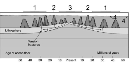
Tablemounts are the features labeled:
A) 1.
B) 2.
C) 3.
D) 4.
Tablemounts are the features labeled:
A) 1.
B) 2.
C) 3.
D) 4.
سؤال
سؤال
سؤال
سؤال
سؤال
سؤال
سؤال
Refer to the below. Use the labeled features on the figure to answer the following question(s).
Seamounts are the feature labeled:
A) 1.
B) 2.
C) 3.
D) 4.
Seamounts are the feature labeled:
A) 1.
B) 2.
C) 3.
D) 4.
سؤال
سؤال
سؤال
سؤال
سؤال
سؤال
Refer to the below. Use the labeled features on the figure to answer the following question(s).
Wave action and plate movement are significant factors in the formation of the feature labeled:
A) 1.
B) 2.
C) 3.
D) 4.
Wave action and plate movement are significant factors in the formation of the feature labeled:
A) 1.
B) 2.
C) 3.
D) 4.
سؤال
سؤال
The sea floor feature in the figure is most likely a result of:
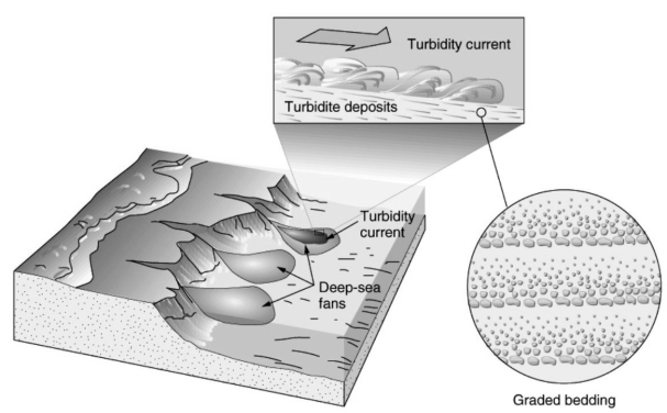
A) pillow lava.
B) submarine fans.
C) turbidity currents.
D) underwater boundary currents.
E) volcanic activity.
A) pillow lava.
B) submarine fans.
C) turbidity currents.
D) underwater boundary currents.
E) volcanic activity.
سؤال
سؤال
سؤال
These organisms are most likely found in:
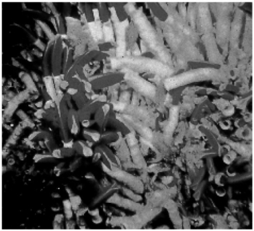
A) abyssal hills.
B) cold seeps.
C) hydrothermal vents.
D) submarine canyons.
E) trenches.
A) abyssal hills.
B) cold seeps.
C) hydrothermal vents.
D) submarine canyons.
E) trenches.
سؤال
سؤال
سؤال
سؤال
سؤال
سؤال
سؤال
سؤال
سؤال
سؤال
سؤال
سؤال
سؤال
سؤال
سؤال
سؤال
Match between columns
سؤال
Match between columns

فتح الحزمة
قم بالتسجيل لفتح البطاقات في هذه المجموعة!
Unlock Deck
Unlock Deck
1/55
العب
ملء الشاشة (f)
Deck 3: Marine Provinces
1
The broadest continental shelves occur in the Arctic Ocean.
True
2
Satellites are used to map the ocean floor because:
A) they are unaffected by surface weather.
B) they can cover areas where ships have not produced surveys.
C) they can "see" large areas of the seafloor at one time.
D) the shape of the ocean surface itself reflects large features on the seafloor below.
E) All of the above statements are correct.
A) they are unaffected by surface weather.
B) they can cover areas where ships have not produced surveys.
C) they can "see" large areas of the seafloor at one time.
D) the shape of the ocean surface itself reflects large features on the seafloor below.
E) All of the above statements are correct.
E
3
The method that is most frequently used to investigate sediment and rock layers of the sea floor is:
A) direct observation.
B) drilling.
C) light waves.
D) satellite observation.
E) sound waves.
A) direct observation.
B) drilling.
C) light waves.
D) satellite observation.
E) sound waves.
E
4
Trenches change their position over time.
فتح الحزمة
افتح القفل للوصول البطاقات البالغ عددها 55 في هذه المجموعة.
فتح الحزمة
k this deck
5
Hydrothermal vents are seafloor cold seeps with high concentrations of sulfur and salts.
فتح الحزمة
افتح القفل للوصول البطاقات البالغ عددها 55 في هذه المجموعة.
فتح الحزمة
k this deck
6
The two relatively flat areas on the hypsometric curve represent:
A) continental mountains and abyssal plains.
B) continental mountains and mid-ocean ridges.
C) continental slopes and deep-sea trenches.
D) some interior continental areas/coastal plains and abyssal plains.
E) some interior continental areas/coastal plains and mid-ocean ridges.
A) continental mountains and abyssal plains.
B) continental mountains and mid-ocean ridges.
C) continental slopes and deep-sea trenches.
D) some interior continental areas/coastal plains and abyssal plains.
E) some interior continental areas/coastal plains and mid-ocean ridges.
فتح الحزمة
افتح القفل للوصول البطاقات البالغ عددها 55 في هذه المجموعة.
فتح الحزمة
k this deck
7
Abyssal plains are more extensive on the floor of the Atlantic as compared to those on the floor of the Pacific.
فتح الحزمة
افتح القفل للوصول البطاقات البالغ عددها 55 في هذه المجموعة.
فتح الحزمة
k this deck
8
Oceans with passive plate margins have continental slopes with more gradual slopes than oceans with active plate margins.
فتح الحزمة
افتح القفل للوصول البطاقات البالغ عددها 55 في هذه المجموعة.
فتح الحزمة
k this deck
9
Black smokers are hydrothermal vents that discharge superheated water with high concentrations of metal sulfides.
فتح الحزمة
افتح القفل للوصول البطاقات البالغ عددها 55 في هذه المجموعة.
فتح الحزمة
k this deck
10
Due to the very harsh environment, few organisms are found in association with hydrothermal vents.
فتح الحزمة
افتح القفل للوصول البطاقات البالغ عددها 55 في هذه المجموعة.
فتح الحزمة
k this deck
11
Mid-ocean ridges are rises that occupy a small portion of the deep ocean basin, only around 10%.
فتح الحزمة
افتح القفل للوصول البطاقات البالغ عددها 55 في هذه المجموعة.
فتح الحزمة
k this deck
12
Seamounts form from ancient tablemounts.
فتح الحزمة
افتح القفل للوصول البطاقات البالغ عددها 55 في هذه المجموعة.
فتح الحزمة
k this deck
13
A sediment-laden current that flows off of the continental shelf is called a turbidity current.
فتح الحزمة
افتح القفل للوصول البطاقات البالغ عددها 55 في هذه المجموعة.
فتح الحزمة
k this deck
14
The Pacific Ring of Fire is the seismically active area at the margins of the Pacific plate where earthquakes and volcanoes are common.
فتح الحزمة
افتح القفل للوصول البطاقات البالغ عددها 55 في هذه المجموعة.
فتح الحزمة
k this deck
15
Sediments of the continental rise can exhibit characteristics similar to those formed by rivers on land.
فتح الحزمة
افتح القفل للوصول البطاقات البالغ عددها 55 في هذه المجموعة.
فتح الحزمة
k this deck
16
Hydrothermal vents have a significant impact on ocean chemistry.
فتح الحزمة
افتح القفل للوصول البطاقات البالغ عددها 55 في هذه المجموعة.
فتح الحزمة
k this deck
17
The deepest portions of the ocean are part of the relatively narrow features called submarine canyons.
فتح الحزمة
افتح القفل للوصول البطاقات البالغ عددها 55 في هذه المجموعة.
فتح الحزمة
k this deck
18
Subduction zones appear to remain nearly stationary over long periods of time.
فتح الحزمة
افتح القفل للوصول البطاقات البالغ عددها 55 في هذه المجموعة.
فتح الحزمة
k this deck
19
Old lithosphere is destroyed in association with:
A) deep-sea trenches
B) fracture zones
C) hydrothermal vents
D) mid-ocean ridges
E) spreading centers.
A) deep-sea trenches
B) fracture zones
C) hydrothermal vents
D) mid-ocean ridges
E) spreading centers.
فتح الحزمة
افتح القفل للوصول البطاقات البالغ عددها 55 في هذه المجموعة.
فتح الحزمة
k this deck
20
Refer to the below. Use the labeled features on the figure to answer the following question(s).
Tablemounts are the features labeled:
A) 1.
B) 2.
C) 3.
D) 4.
Tablemounts are the features labeled:
A) 1.
B) 2.
C) 3.
D) 4.
فتح الحزمة
افتح القفل للوصول البطاقات البالغ عددها 55 في هذه المجموعة.
فتح الحزمة
k this deck
21
Warm-water hydrothermal vents form:
A) abyssal hills.
B) black smokers.
C) cold seeps.
D) turbidity currents.
E) white smokers.
A) abyssal hills.
B) black smokers.
C) cold seeps.
D) turbidity currents.
E) white smokers.
فتح الحزمة
افتح القفل للوصول البطاقات البالغ عددها 55 في هذه المجموعة.
فتح الحزمة
k this deck
22
Abyssal hills are only visible in the Pacific Ocean because:
A) sediment has covered those found in the other ocean basins.
B) there are none in the Atlantic and Indian ocean basins.
C) they are higher in the Pacific than in the other ocean basins
D) they have been destroyed in active plate margins.
E) turbidity currents have eroded abyssal hills in the other ocean basins.
فتح الحزمة
افتح القفل للوصول البطاقات البالغ عددها 55 في هذه المجموعة.
فتح الحزمة
k this deck
23
Continental rises are formed:
A) as a result of the slow accumulation of sediments from the water column.
B) by many deep sea fans.
C) in association with hydrothermal vents
D) next to submarine canyons.
E) on the flank of a mid-ocean ridge.
A) as a result of the slow accumulation of sediments from the water column.
B) by many deep sea fans.
C) in association with hydrothermal vents
D) next to submarine canyons.
E) on the flank of a mid-ocean ridge.
فتح الحزمة
افتح القفل للوصول البطاقات البالغ عددها 55 في هذه المجموعة.
فتح الحزمة
k this deck
24
The most gradual change in slope in the ocean can be found at the:
A) abyssal plain.
B) continental rise.
C) continental shelf.
D) deep ocean trench.
E) mid-ocean ridge.
A) abyssal plain.
B) continental rise.
C) continental shelf.
D) deep ocean trench.
E) mid-ocean ridge.
فتح الحزمة
افتح القفل للوصول البطاقات البالغ عددها 55 في هذه المجموعة.
فتح الحزمة
k this deck
25
Directly seaward of the continental shelf is a more steeply sloping region called the:
A) abyssal plain.
B) continental rise.
C) continental slope.
D) mid-ocean ridge.
E) trench.
A) abyssal plain.
B) continental rise.
C) continental slope.
D) mid-ocean ridge.
E) trench.
فتح الحزمة
افتح القفل للوصول البطاقات البالغ عددها 55 في هذه المجموعة.
فتح الحزمة
k this deck
26
Submarine canyons were most likely formed by:
A) deposition of terrestrial sediment.
B) earthquake activity.
C) erosion by major rivers in the past.
D) erosion by turbidity currents.
E) scouring by glaciers during the last ice age.
A) deposition of terrestrial sediment.
B) earthquake activity.
C) erosion by major rivers in the past.
D) erosion by turbidity currents.
E) scouring by glaciers during the last ice age.
فتح الحزمة
افتح القفل للوصول البطاقات البالغ عددها 55 في هذه المجموعة.
فتح الحزمة
k this deck
27
Refer to the below. Use the labeled features on the figure to answer the following question(s).
Seamounts are the feature labeled:
A) 1.
B) 2.
C) 3.
D) 4.
Seamounts are the feature labeled:
A) 1.
B) 2.
C) 3.
D) 4.
فتح الحزمة
افتح القفل للوصول البطاقات البالغ عددها 55 في هذه المجموعة.
فتح الحزمة
k this deck
28
The most rapid change in slope in the ocean is found at the:
A) abyssal plain.
B) continental slope.
C) oceanic trench.
D) submarine canyon.
E) volcanic seamount.
A) abyssal plain.
B) continental slope.
C) oceanic trench.
D) submarine canyon.
E) volcanic seamount.
فتح الحزمة
افتح القفل للوصول البطاقات البالغ عددها 55 في هذه المجموعة.
فتح الحزمة
k this deck
29
With respect to mid-ocean ridges, transform faults are:
A) associated with hydrothermal vents.
B) located in submarine canyons.
C) parallel to the direction of plate movement.
D) parallel to the rift valley.
E) perpendicular to the ridge axis.
A) associated with hydrothermal vents.
B) located in submarine canyons.
C) parallel to the direction of plate movement.
D) parallel to the rift valley.
E) perpendicular to the ridge axis.
فتح الحزمة
افتح القفل للوصول البطاقات البالغ عددها 55 في هذه المجموعة.
فتح الحزمة
k this deck
30
Passive continental margins are characterized by all of the following except:
A) broad continental shelf.
B) deep-sea trenches.
C) shallow coastal waters.
D) thick sediment accumulation.
E) very little volcanic and earthquake activity.
A) broad continental shelf.
B) deep-sea trenches.
C) shallow coastal waters.
D) thick sediment accumulation.
E) very little volcanic and earthquake activity.
فتح الحزمة
افتح القفل للوصول البطاقات البالغ عددها 55 في هذه المجموعة.
فتح الحزمة
k this deck
31
The correct order of marine provinces from the coast to the mid-ocean ridge is:
A) abyssal plain, rise, slope, shelf.
B) abyssal plain, shelf, slope, rise.
C) rise, abyssal plain, slope, shelf.
D) shelf, slope, rise, abyssal plain.
E) slope, rise, shelf, abyssal plain.
A) abyssal plain, rise, slope, shelf.
B) abyssal plain, shelf, slope, rise.
C) rise, abyssal plain, slope, shelf.
D) shelf, slope, rise, abyssal plain.
E) slope, rise, shelf, abyssal plain.
فتح الحزمة
افتح القفل للوصول البطاقات البالغ عددها 55 في هذه المجموعة.
فتح الحزمة
k this deck
32
The direction of motion along a seafloor transform fault is:
A) associated with turbidity currents.
B) in the same direction as the plates are spreading.
C) in the same direction as the ridge offset.
D) influenced by underwater boundary currents.
E) perpendicular to the direction of plate movement.
A) associated with turbidity currents.
B) in the same direction as the plates are spreading.
C) in the same direction as the ridge offset.
D) influenced by underwater boundary currents.
E) perpendicular to the direction of plate movement.
فتح الحزمة
افتح القفل للوصول البطاقات البالغ عددها 55 في هذه المجموعة.
فتح الحزمة
k this deck
33
Refer to the below. Use the labeled features on the figure to answer the following question(s).
Wave action and plate movement are significant factors in the formation of the feature labeled:
A) 1.
B) 2.
C) 3.
D) 4.
Wave action and plate movement are significant factors in the formation of the feature labeled:
A) 1.
B) 2.
C) 3.
D) 4.
فتح الحزمة
افتح القفل للوصول البطاقات البالغ عددها 55 في هذه المجموعة.
فتح الحزمة
k this deck
34
All of the following are considered part of the continental margin except the:
A) continental rise.
B) continental shelf.
C) continental slope.
D) fracture zone.
E) submarine canyon.
A) continental rise.
B) continental shelf.
C) continental slope.
D) fracture zone.
E) submarine canyon.
فتح الحزمة
افتح القفل للوصول البطاقات البالغ عددها 55 في هذه المجموعة.
فتح الحزمة
k this deck
35
The sea floor feature in the figure is most likely a result of:
A) pillow lava.
B) submarine fans.
C) turbidity currents.
D) underwater boundary currents.
E) volcanic activity.
A) pillow lava.
B) submarine fans.
C) turbidity currents.
D) underwater boundary currents.
E) volcanic activity.
فتح الحزمة
افتح القفل للوصول البطاقات البالغ عددها 55 في هذه المجموعة.
فتح الحزمة
k this deck
36
Characteristics of active continental margins include all of the following except:
A) broad continental shelf.
B) chains of islands.
C) deep-sea trenches.
D) thin sediment accumulation.
E) volcanic and earthquake activity.
A) broad continental shelf.
B) chains of islands.
C) deep-sea trenches.
D) thin sediment accumulation.
E) volcanic and earthquake activity.
فتح الحزمة
افتح القفل للوصول البطاقات البالغ عددها 55 في هذه المجموعة.
فتح الحزمة
k this deck
37
New lithosphere is produced in association with:
A) deep-sea trenches.
B) fracture zones.
C) hydrothermal vents.
D) mid-ocean ridges.
E) transform faults.
A) deep-sea trenches.
B) fracture zones.
C) hydrothermal vents.
D) mid-ocean ridges.
E) transform faults.
فتح الحزمة
افتح القفل للوصول البطاقات البالغ عددها 55 في هذه المجموعة.
فتح الحزمة
k this deck
38
These organisms are most likely found in:
A) abyssal hills.
B) cold seeps.
C) hydrothermal vents.
D) submarine canyons.
E) trenches.
A) abyssal hills.
B) cold seeps.
C) hydrothermal vents.
D) submarine canyons.
E) trenches.
فتح الحزمة
افتح القفل للوصول البطاقات البالغ عددها 55 في هذه المجموعة.
فتح الحزمة
k this deck
39
All of the following are features associated with active plate margins except:
A) black smoker.
B) continental rise.
C) rift valley.
D) trench.
E) volcanic arc.
A) black smoker.
B) continental rise.
C) rift valley.
D) trench.
E) volcanic arc.
فتح الحزمة
افتح القفل للوصول البطاقات البالغ عددها 55 في هذه المجموعة.
فتح الحزمة
k this deck
40
Examine the five words and/or phrases and determine the relationship among the majority of words/phrases. Choose the one option that does not fit the pattern.
A)abyssal hill
B)guyot
C)ridge crest
D)sea knoll
E)tablemount
A)abyssal hill
B)guyot
C)ridge crest
D)sea knoll
E)tablemount
فتح الحزمة
افتح القفل للوصول البطاقات البالغ عددها 55 في هذه المجموعة.
فتح الحزمة
k this deck
41
Draw and label the features of the Atlantic Ocean basin as you move from the continent toward the center of the ocean basins.
فتح الحزمة
افتح القفل للوصول البطاقات البالغ عددها 55 في هذه المجموعة.
فتح الحزمة
k this deck
42
Examine the five words and/or phrases and determine the relationship among the majority of words/phrases. Choose the one option that does not fit the pattern.
A)global positioning satellite (GPS)
B)GLORIA
C)precision depth recorder (PDR)
D)SeaBeam
E)SeaMarc
A)global positioning satellite (GPS)
B)GLORIA
C)precision depth recorder (PDR)
D)SeaBeam
E)SeaMarc
فتح الحزمة
افتح القفل للوصول البطاقات البالغ عددها 55 في هذه المجموعة.
فتح الحزمة
k this deck
43
The instrument that emits a high-frequency sound beam to measure the depth of the ocean developed in the 1950s is the:
A) GLORIA.
B) PDR.
C) Seabeam.
D) SeaMARC.
E) SeaWif.
A) GLORIA.
B) PDR.
C) Seabeam.
D) SeaMARC.
E) SeaWif.
فتح الحزمة
افتح القفل للوصول البطاقات البالغ عددها 55 في هذه المجموعة.
فتح الحزمة
k this deck
44
Differentiate between active and passive plate margins and give an example of each.
فتح الحزمة
افتح القفل للوصول البطاقات البالغ عددها 55 في هذه المجموعة.
فتح الحزمة
k this deck
45
Describe the three major marine provinces and list and describe the features associated with each province.
فتح الحزمة
افتح القفل للوصول البطاقات البالغ عددها 55 في هذه المجموعة.
فتح الحزمة
k this deck
46
Underwater avalanches of muddy water mixed with rocks and debris are:
A) deep sea fans.
B) graded bedding.
C) turbidity currents.
D) turbidite deposits.
E) white smokers.
A) deep sea fans.
B) graded bedding.
C) turbidity currents.
D) turbidite deposits.
E) white smokers.
فتح الحزمة
افتح القفل للوصول البطاقات البالغ عددها 55 في هذه المجموعة.
فتح الحزمة
k this deck
47
Distinguish between white smoker and black smoker hydrothermal vents.
فتح الحزمة
افتح القفل للوصول البطاقات البالغ عددها 55 في هذه المجموعة.
فتح الحزمة
k this deck
48
Discuss the development of scientific instruments in the 20ᵗʰ century used to map the seafloor. Include in your answer the time frame when each instrument was developed and include a brief description of how it works.
فتح الحزمة
افتح القفل للوصول البطاقات البالغ عددها 55 في هذه المجموعة.
فتح الحزمة
k this deck
49
Examine the five words and/or phrases and determine the relationship among the majority of words/phrases. Choose the one option that does not fit the pattern.
A)black smoker
B)deep focus earthquake
C)hydrothermal vent
D)rift valley
E)white smoker
A)black smoker
B)deep focus earthquake
C)hydrothermal vent
D)rift valley
E)white smoker
فتح الحزمة
افتح القفل للوصول البطاقات البالغ عددها 55 في هذه المجموعة.
فتح الحزمة
k this deck
50
Examine the five words and/or phrases and determine the relationship among the majority of words/phrases. Choose the one option that does not fit the pattern.
A)abyssal plain
B)continental flood basalt
C)continental rise
D)continental shelf
E)continental slope
A)abyssal plain
B)continental flood basalt
C)continental rise
D)continental shelf
E)continental slope
فتح الحزمة
افتح القفل للوصول البطاقات البالغ عددها 55 في هذه المجموعة.
فتح الحزمة
k this deck
51
Describe the relationship between turbidity currents and turbidite deposits.
فتح الحزمة
افتح القفل للوصول البطاقات البالغ عددها 55 في هذه المجموعة.
فتح الحزمة
k this deck
52
Examine the five words and/or phrases and determine the relationship among the majority of words/phrases. Choose the one option that does not fit the pattern.
A)metal sulfide deposits
B)pillow basalts
C)rift valley
D)seamounts
E)trenches.
A)metal sulfide deposits
B)pillow basalts
C)rift valley
D)seamounts
E)trenches.
فتح الحزمة
افتح القفل للوصول البطاقات البالغ عددها 55 في هذه المجموعة.
فتح الحزمة
k this deck
53
Distinguish between a transform fault and a fracture zone.
فتح الحزمة
افتح القفل للوصول البطاقات البالغ عددها 55 في هذه المجموعة.
فتح الحزمة
k this deck
54
Match between columns
فتح الحزمة
افتح القفل للوصول البطاقات البالغ عددها 55 في هذه المجموعة.
فتح الحزمة
k this deck
55
Match between columns
فتح الحزمة
افتح القفل للوصول البطاقات البالغ عددها 55 في هذه المجموعة.
فتح الحزمة
k this deck
فتح الحزمة
افتح القفل للوصول البطاقات البالغ عددها 55 في هذه المجموعة.


