Deck 6: Air-Sea Interface
ملء الشاشة (f)
سؤال
سؤال
سؤال
سؤال
سؤال
سؤال
سؤال
سؤال
سؤال
سؤال
سؤال
سؤال
سؤال
سؤال
سؤال
سؤال
سؤال
سؤال
سؤال
سؤال
Refer to the figure below and use the numbers that correspond to global wind belts and latitudes to answer the following question(s).
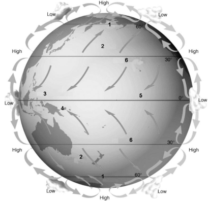
The area of the globe (latitude) that is characterized by falling air masses and little precipitation is:
A) 1.
B) 2.
C) 3.
D) 5.
E) 6.
The area of the globe (latitude) that is characterized by falling air masses and little precipitation is:
A) 1.
B) 2.
C) 3.
D) 5.
E) 6.
سؤال
سؤال
سؤال
سؤال
سؤال
Refer to the figure below and use the numbers that correspond to global wind belts and latitudes to answer the following question(s).
The westerlies wind belt is the area corresponding to:
A) 1.
B) 2.
C) 3.
D) 4.
E) 5.
The westerlies wind belt is the area corresponding to:
A) 1.
B) 2.
C) 3.
D) 4.
E) 5.
سؤال
Refer to the figure below and use the numbers that correspond to global wind belts and latitudes to answer the following question(s).
The strongest winds on Earth are:
A) 1 & 2.
B) 1 & 3.
C) 2 & 3.
D) 2 & 4.
E) 3 & 4.
The strongest winds on Earth are:
A) 1 & 2.
B) 1 & 3.
C) 2 & 3.
D) 2 & 4.
E) 3 & 4.
سؤال
سؤال
سؤال
سؤال
سؤال
Refer to the figure below and use the numbers that correspond to global wind belts and latitudes to answer the following question(s).
The wind belt that corresponds to the doldrums is labeled:
A) 1.
B) 2.
C) 3.
D) 5.
E) 6.
The wind belt that corresponds to the doldrums is labeled:
A) 1.
B) 2.
C) 3.
D) 5.
E) 6.
سؤال
سؤال
سؤال
سؤال
سؤال
سؤال
سؤال
سؤال
سؤال
سؤال
سؤال
سؤال
سؤال
سؤال
سؤال
سؤال
سؤال
سؤال
سؤال
سؤال
سؤال
Refer to the figure below, and use the information on the map corresponding to the ocean's climatic regions to answer the following question(s).
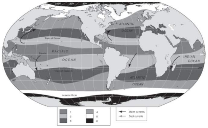
The oceanic climate region that is characterized by sea ice coverage in the winter and open water (but cold) in the summer is indicated by the number:
A) 2.
B) 3.
C) 4.
D) 5.
E) 6.
The oceanic climate region that is characterized by sea ice coverage in the winter and open water (but cold) in the summer is indicated by the number:
A) 2.
B) 3.
C) 4.
D) 5.
E) 6.
سؤال
سؤال
سؤال
Refer to the figure below, and use the information on the map corresponding to the ocean's climatic regions to answer the following question(s).
The oceanic climate region(s) in the majority of strong cyclonic storms are produced is indicated by the number:
A) 1.
B) 1 & 2.
C) 2.
D) 3.
E) 3 & 4.
The oceanic climate region(s) in the majority of strong cyclonic storms are produced is indicated by the number:
A) 1.
B) 1 & 2.
C) 2.
D) 3.
E) 3 & 4.
سؤال
سؤال
سؤال
سؤال
Match between columns
سؤال
Match between columns

فتح الحزمة
قم بالتسجيل لفتح البطاقات في هذه المجموعة!
Unlock Deck
Unlock Deck
1/60
العب
ملء الشاشة (f)
Deck 6: Air-Sea Interface
1
The jet stream is a fast moving easterly flowing air mass.
True
2
The percentage of incident light radiation reflected back to space is termed albedo.
True
3
A mole of methane is able to absorb much more heat than one mole of carbon dioxide.
True
4
An iceberg is a variety of sea ice.
فتح الحزمة
افتح القفل للوصول البطاقات البالغ عددها 60 في هذه المجموعة.
فتح الحزمة
k this deck
5
Near the poles, more energy is reflected back into space than is absorbed.
فتح الحزمة
افتح القفل للوصول البطاقات البالغ عددها 60 في هذه المجموعة.
فتح الحزمة
k this deck
6
The wavelength of energy radiated from the Earth back into the atmosphere is longer than the incoming solar radiation.
فتح الحزمة
افتح القفل للوصول البطاقات البالغ عددها 60 في هذه المجموعة.
فتح الحزمة
k this deck
7
A maritime polar air mass is likely to be dry and cold.
فتح الحزمة
افتح القفل للوصول البطاقات البالغ عددها 60 في هذه المجموعة.
فتح الحزمة
k this deck
8
A hurricane contains more energy than has been generated in the U.S. over the last twenty years.
فتح الحزمة
افتح القفل للوصول البطاقات البالغ عددها 60 في هذه المجموعة.
فتح الحزمة
k this deck
9
Sound travels more slowly in the SOFAR channel than in the areas of the ocean immediately above and below it.
فتح الحزمة
افتح القفل للوصول البطاقات البالغ عددها 60 في هذه المجموعة.
فتح الحزمة
k this deck
10
The trade winds can be found between 30° and 60°N and S latitudes.
فتح الحزمة
افتح القفل للوصول البطاقات البالغ عددها 60 في هذه المجموعة.
فتح الحزمة
k this deck
11
A hurricane is a very strong high-pressure system.
فتح الحزمة
افتح القفل للوصول البطاقات البالغ عددها 60 في هذه المجموعة.
فتح الحزمة
k this deck
12
The autumnal equinox occurs when the sun is directly overhead along the equator in March.
فتح الحزمة
افتح القفل للوصول البطاقات البالغ عددها 60 في هذه المجموعة.
فتح الحزمة
k this deck
13
A cold front is likely to have heavy, brief showers associated with it.
فتح الحزمة
افتح القفل للوصول البطاقات البالغ عددها 60 في هذه المجموعة.
فتح الحزمة
k this deck
14
The greenhouse gas that accounts for most of the natural greenhouse effect in Earth's atmosphere is carbon dioxide.
فتح الحزمة
افتح القفل للوصول البطاقات البالغ عددها 60 في هذه المجموعة.
فتح الحزمة
k this deck
15
The angle at which direct sunlight strikes the ocean's surface is important in determining the amount of solar energy that is absorbed.
فتح الحزمة
افتح القفل للوصول البطاقات البالغ عددها 60 في هذه المجموعة.
فتح الحزمة
k this deck
16
The best climate models indicate that Earth's average surface temperature has risen by 5°C in the last 100 years.
فتح الحزمة
افتح القفل للوصول البطاقات البالغ عددها 60 في هذه المجموعة.
فتح الحزمة
k this deck
17
Glaciers and sea ice have a high albedo.
فتح الحزمة
افتح القفل للوصول البطاقات البالغ عددها 60 في هذه المجموعة.
فتح الحزمة
k this deck
18
The doldrums can be found at the Equator.
فتح الحزمة
افتح القفل للوصول البطاقات البالغ عددها 60 في هذه المجموعة.
فتح الحزمة
k this deck
19
Low pressure systems in the northern hemisphere rotate:
A) at a 45º angle from the prevailing wind direction.
B) clockwise.
C) counterclockwise.
D) to the left.
E) to the right.
A) at a 45º angle from the prevailing wind direction.
B) clockwise.
C) counterclockwise.
D) to the left.
E) to the right.
فتح الحزمة
افتح القفل للوصول البطاقات البالغ عددها 60 في هذه المجموعة.
فتح الحزمة
k this deck
20
Refer to the figure below and use the numbers that correspond to global wind belts and latitudes to answer the following question(s).
The area of the globe (latitude) that is characterized by falling air masses and little precipitation is:
A) 1.
B) 2.
C) 3.
D) 5.
E) 6.
The area of the globe (latitude) that is characterized by falling air masses and little precipitation is:
A) 1.
B) 2.
C) 3.
D) 5.
E) 6.
فتح الحزمة
افتح القفل للوصول البطاقات البالغ عددها 60 في هذه المجموعة.
فتح الحزمة
k this deck
21
Winds blowing from the north in the southern hemisphere will appear to :
A) be deflected toward the east.
B) be deflected toward the west.
C) circulate counterclockwise.
D) circulate clockwise.
E) travel in a straight line.
A) be deflected toward the east.
B) be deflected toward the west.
C) circulate counterclockwise.
D) circulate clockwise.
E) travel in a straight line.
فتح الحزمة
افتح القفل للوصول البطاقات البالغ عددها 60 في هذه المجموعة.
فتح الحزمة
k this deck
22
A cold air mass moving into an area occupied by relatively warm air is called a(n):
A) cold front.
B) high pressure system.
C) low pressure system.
D) occluded front.
E) warm front.
A) cold front.
B) high pressure system.
C) low pressure system.
D) occluded front.
E) warm front.
فتح الحزمة
افتح القفل للوصول البطاقات البالغ عددها 60 في هذه المجموعة.
فتح الحزمة
k this deck
23
The Saffir-Simpson scale rates the relative intensity of tropical cylones.
فتح الحزمة
افتح القفل للوصول البطاقات البالغ عددها 60 في هذه المجموعة.
فتح الحزمة
k this deck
24
As a result of the Coriolis effect in the northern hemisphere, winds are deflected:
A) at a 45° angle form the original direction.
B) at a 90° angle from the original direction.
C) to the east of the original direction.
D) to the left of the original direction.
E) to the right of the original direction.
A) at a 45° angle form the original direction.
B) at a 90° angle from the original direction.
C) to the east of the original direction.
D) to the left of the original direction.
E) to the right of the original direction.
فتح الحزمة
افتح القفل للوصول البطاقات البالغ عددها 60 في هذه المجموعة.
فتح الحزمة
k this deck
25
Refer to the figure below and use the numbers that correspond to global wind belts and latitudes to answer the following question(s).
The westerlies wind belt is the area corresponding to:
A) 1.
B) 2.
C) 3.
D) 4.
E) 5.
The westerlies wind belt is the area corresponding to:
A) 1.
B) 2.
C) 3.
D) 4.
E) 5.
فتح الحزمة
افتح القفل للوصول البطاقات البالغ عددها 60 في هذه المجموعة.
فتح الحزمة
k this deck
26
Refer to the figure below and use the numbers that correspond to global wind belts and latitudes to answer the following question(s).
The strongest winds on Earth are:
A) 1 & 2.
B) 1 & 3.
C) 2 & 3.
D) 2 & 4.
E) 3 & 4.
The strongest winds on Earth are:
A) 1 & 2.
B) 1 & 3.
C) 2 & 3.
D) 2 & 4.
E) 3 & 4.
فتح الحزمة
افتح القفل للوصول البطاقات البالغ عددها 60 في هذه المجموعة.
فتح الحزمة
k this deck
27
The Tropic of Capricorn is located at:
A) 0° longitude.
B) 23.5°N latitude.
C) 23.5°S latitude.
D) 30°N latitude.
E) 60°S latitude.
A) 0° longitude.
B) 23.5°N latitude.
C) 23.5°S latitude.
D) 30°N latitude.
E) 60°S latitude.
فتح الحزمة
افتح القفل للوصول البطاقات البالغ عددها 60 في هذه المجموعة.
فتح الحزمة
k this deck
28
The temperate regions are characterized by:
A) cold fronts.
B) high pressure.
C) easterly winds.
D) trade winds.
E) westerly winds.
A) cold fronts.
B) high pressure.
C) easterly winds.
D) trade winds.
E) westerly winds.
فتح الحزمة
افتح القفل للوصول البطاقات البالغ عددها 60 في هذه المجموعة.
فتح الحزمة
k this deck
29
A maritime tropical air mass is likely to be:
A) dry and cold.
B) dry and warm.
C) wet and cold.
D) wet and the same temperature.
E) wet and warm.
A) dry and cold.
B) dry and warm.
C) wet and cold.
D) wet and the same temperature.
E) wet and warm.
فتح الحزمة
افتح القفل للوصول البطاقات البالغ عددها 60 في هذه المجموعة.
فتح الحزمة
k this deck
30
The percentage of solar radiation absorbed by the Earth's oceans and landmasses is about:
A) 25%.
B) 30%.
C) 50%.
D) 70%.
E) 90%.
A) 25%.
B) 30%.
C) 50%.
D) 70%.
E) 90%.
فتح الحزمة
افتح القفل للوصول البطاقات البالغ عددها 60 في هذه المجموعة.
فتح الحزمة
k this deck
31
Refer to the figure below and use the numbers that correspond to global wind belts and latitudes to answer the following question(s).
The wind belt that corresponds to the doldrums is labeled:
A) 1.
B) 2.
C) 3.
D) 5.
E) 6.
The wind belt that corresponds to the doldrums is labeled:
A) 1.
B) 2.
C) 3.
D) 5.
E) 6.
فتح الحزمة
افتح القفل للوصول البطاقات البالغ عددها 60 في هذه المجموعة.
فتح الحزمة
k this deck
32
With respect to the amount of energy absorbed by the atmosphere, the amount of energy radiated back into space between 35°N and 40°S latitude is:
A) about the same as the amount of energy absorbed by the atmosphere.
B) dependent upon the weather conditions, such as cloud cover, in the local area.
C) greater than the amount of energy absorbed by the atmosphere.
D) less than the amount of energy absorbed by the atmosphere,
E) unrelated to latitude.
فتح الحزمة
افتح القفل للوصول البطاقات البالغ عددها 60 في هذه المجموعة.
فتح الحزمة
k this deck
33
Idealized pressure belts and wind systems are significantly modified by Earth's tilted axis of rotation and:
A) differences in the heat capacity of ocean and land.
B) differences in the latitudinal albedo.
C) Ekman transport.
D) latitudinal variations in the Coriolis effect.
E) variations in incoming solar radiation over many years.
A) differences in the heat capacity of ocean and land.
B) differences in the latitudinal albedo.
C) Ekman transport.
D) latitudinal variations in the Coriolis effect.
E) variations in incoming solar radiation over many years.
فتح الحزمة
افتح القفل للوصول البطاقات البالغ عددها 60 في هذه المجموعة.
فتح الحزمة
k this deck
34
The deflection of air masses to the right or left (depending on latitude) as they move from one latitude to another is called the:
A) Coriolis effect.
B) Cyclonic effect.
C) Ekman spiral.
D) Hadley cell.
E) Saffir-Simpson scale.
A) Coriolis effect.
B) Cyclonic effect.
C) Ekman spiral.
D) Hadley cell.
E) Saffir-Simpson scale.
فتح الحزمة
افتح القفل للوصول البطاقات البالغ عددها 60 في هذه المجموعة.
فتح الحزمة
k this deck
35
With respect to incoming solar radiation, radiation emitted back into the atmosphere has:
A) a longer wave frequency.
B) a longer wavelength.
C) a shorter wave period.
D) a shorter wavelength.
E) the same wavelength.
A) a longer wave frequency.
B) a longer wavelength.
C) a shorter wave period.
D) a shorter wavelength.
E) the same wavelength.
فتح الحزمة
افتح القفل للوصول البطاقات البالغ عددها 60 في هذه المجموعة.
فتح الحزمة
k this deck
36
The percentage of solar radiation directed to Earth absorbed by the clouds and the atmosphere is about:
A) 10%.
B) 25%.
C) 30%.
D) 50%.
E) 70%.
A) 10%.
B) 25%.
C) 30%.
D) 50%.
E) 70%.
فتح الحزمة
افتح القفل للوصول البطاقات البالغ عددها 60 في هذه المجموعة.
فتح الحزمة
k this deck
37
The doldrums refer to the same region as the:
A) intertropical convergence zone.
B) jet stream.
C) subtropical jet stream.
D) subtropics.
E) trade winds.
A) intertropical convergence zone.
B) jet stream.
C) subtropical jet stream.
D) subtropics.
E) trade winds.
فتح الحزمة
افتح القفل للوصول البطاقات البالغ عددها 60 في هذه المجموعة.
فتح الحزمة
k this deck
38
Wind is initiated by thermal heating from the sun and cooling by the ocean creating a thermal convection cell.
فتح الحزمة
افتح القفل للوصول البطاقات البالغ عددها 60 في هذه المجموعة.
فتح الحزمة
k this deck
39
Discuss the formation of land breezes and sea breezes.
فتح الحزمة
افتح القفل للوصول البطاقات البالغ عددها 60 في هذه المجموعة.
فتح الحزمة
k this deck
40
What are the differences between hurricanes, typhoons, and tropical cyclones?
فتح الحزمة
افتح القفل للوصول البطاقات البالغ عددها 60 في هذه المجموعة.
فتح الحزمة
k this deck
41
The oceanic climate region(s) in the majority of strong cyclonic storms are produced is indicated by the number:
A) 1.
B) 1 & 2.
C) 2.
D) 3.
E) 3 & 4.
A) 1.
B) 1 & 2.
C) 2.
D) 3.
E) 3 & 4.
فتح الحزمة
افتح القفل للوصول البطاقات البالغ عددها 60 في هذه المجموعة.
فتح الحزمة
k this deck
42
Examine the five words and/or phrases and determine the relationship among the majority of words/phrases. Choose the one option that does not fit the pattern.
A)max. sustained winds
B)min. central pressure
C)sea surface temp.
D)storm surge
E)wind field di
A)
A)max. sustained winds
B)min. central pressure
C)sea surface temp.
D)storm surge
E)wind field di
A)
فتح الحزمة
افتح القفل للوصول البطاقات البالغ عددها 60 في هذه المجموعة.
فتح الحزمة
k this deck
43
Discuss the impact of the Coriolis effect on atmospheric circulation. Provide at least two examples where the Coriolis effect significantly impacts global atmospheric circulation.
فتح الحزمة
افتح القفل للوصول البطاقات البالغ عددها 60 في هذه المجموعة.
فتح الحزمة
k this deck
44
Distinguish between weather and climate.
فتح الحزمة
افتح القفل للوصول البطاقات البالغ عددها 60 في هذه المجموعة.
فتح الحزمة
k this deck
45
Describe the impact of cyclones on the Earth's heat budget? How are the number and frequency of cyclones related to latitude and season?
فتح الحزمة
افتح القفل للوصول البطاقات البالغ عددها 60 في هذه المجموعة.
فتح الحزمة
k this deck
46
Discuss uneven solar heating as a function of latitude and how this contributes to the formation of global wind belts.
فتح الحزمة
افتح القفل للوصول البطاقات البالغ عددها 60 في هذه المجموعة.
فتح الحزمة
k this deck
47
The wind belt(s) with strong, reliable, generally easterly winds is (are) the:
A) doldrums
B) horse latitudes.
C) polar easterlies.
D) trade winds.
E) westerlies.
A) doldrums
B) horse latitudes.
C) polar easterlies.
D) trade winds.
E) westerlies.
فتح الحزمة
افتح القفل للوصول البطاقات البالغ عددها 60 في هذه المجموعة.
فتح الحزمة
k this deck
48
The strength of a hurricane is ranked from 1 to 5 on the:
A) Coriolis Scale.
B) Fujita Scale.
C) Moh's Scale.
D) Richter Scale.
E) Saffir-Simpson Scale.
A) Coriolis Scale.
B) Fujita Scale.
C) Moh's Scale.
D) Richter Scale.
E) Saffir-Simpson Scale.
فتح الحزمة
افتح القفل للوصول البطاقات البالغ عددها 60 في هذه المجموعة.
فتح الحزمة
k this deck
49
Colder air moving over significantly warmer ocean surface water may produce:
A) a cold front.
B) a warm front.
C) changes in coastal wind direction.
D) increased coastal precipitation..
E) sea smoke.
A) a cold front.
B) a warm front.
C) changes in coastal wind direction.
D) increased coastal precipitation..
E) sea smoke.
فتح الحزمة
افتح القفل للوصول البطاقات البالغ عددها 60 في هذه المجموعة.
فتح الحزمة
k this deck
50
Examine the five words and/or phrases and determine the relationship among the majority of words/phrases. Choose the one option that does not fit the pattern.
A)doldrums
B)northeast trades
C)polar easterlies
D)southeast trades
E)westerlies
A)doldrums
B)northeast trades
C)polar easterlies
D)southeast trades
E)westerlies
فتح الحزمة
افتح القفل للوصول البطاقات البالغ عددها 60 في هذه المجموعة.
فتح الحزمة
k this deck
51
Hurricanes are an efficient way to:
A) decrease salinity in affected estuaries.
B) eradicate rainfall deficits.
C) raise local sea level due to storm surge.
D) redistribute heat from one area to another.
E) remove old-growth coastal forests.
A) decrease salinity in affected estuaries.
B) eradicate rainfall deficits.
C) raise local sea level due to storm surge.
D) redistribute heat from one area to another.
E) remove old-growth coastal forests.
فتح الحزمة
افتح القفل للوصول البطاقات البالغ عددها 60 في هذه المجموعة.
فتح الحزمة
k this deck
52
Refer to the figure below, and use the information on the map corresponding to the ocean's climatic regions to answer the following question(s).
The oceanic climate region that is characterized by sea ice coverage in the winter and open water (but cold) in the summer is indicated by the number:
A) 2.
B) 3.
C) 4.
D) 5.
E) 6.
The oceanic climate region that is characterized by sea ice coverage in the winter and open water (but cold) in the summer is indicated by the number:
A) 2.
B) 3.
C) 4.
D) 5.
E) 6.
فتح الحزمة
افتح القفل للوصول البطاقات البالغ عددها 60 في هذه المجموعة.
فتح الحزمة
k this deck
53
How do water vapor and particles in the atmosphere complicate the creation of models of the Earth's atmosphere?
فتح الحزمة
افتح القفل للوصول البطاقات البالغ عددها 60 في هذه المجموعة.
فتح الحزمة
k this deck
54
Compare and contrast the formation of high pressure and low pressure atmospheric systems on precipitation and temperature in the areas where they form.
فتح الحزمة
افتح القفل للوصول البطاقات البالغ عددها 60 في هذه المجموعة.
فتح الحزمة
k this deck
55
Refer to the figure below, and use the information on the map corresponding to the ocean's climatic regions to answer the following question(s).
The oceanic climate region(s) in the majority of strong cyclonic storms are produced is indicated by the number:
A) 1.
B) 1 & 2.
C) 2.
D) 3.
E) 3 & 4.
The oceanic climate region(s) in the majority of strong cyclonic storms are produced is indicated by the number:
A) 1.
B) 1 & 2.
C) 2.
D) 3.
E) 3 & 4.
فتح الحزمة
افتح القفل للوصول البطاقات البالغ عددها 60 في هذه المجموعة.
فتح الحزمة
k this deck
56
Examine the five words and/or phrases and determine the relationship among the majority of words/phrases. Choose the one option that does not fit the pattern.
A)continent
B)glacier
C)ice floe
D)ocean
E)sea ice
A)continent
B)glacier
C)ice floe
D)ocean
E)sea ice
فتح الحزمة
افتح القفل للوصول البطاقات البالغ عددها 60 في هذه المجموعة.
فتح الحزمة
k this deck
57
When ice forms from seawater, the remaining seawater will have a:
A) darker color.
B) decreased density.
C) higher salinity.
D) higher temperature.
E) lower temperature.
A) darker color.
B) decreased density.
C) higher salinity.
D) higher temperature.
E) lower temperature.
فتح الحزمة
افتح القفل للوصول البطاقات البالغ عددها 60 في هذه المجموعة.
فتح الحزمة
k this deck
58
All of the following are true of the Earth's climate except:
A) a column of cool, dense air produces high pressure at the Earth's surface.
B) a column of warm, less dense air produces low pressure at the Earth's surface.
C) cool air is more dense than warm air so it tends to sink toward the Earth's surface.
D) the movement of air within the atmospheric convection cells generates the Earth's major wind belts.
E) warm air is less dense than cool air so it tends to sink toward the Earth's surface.
فتح الحزمة
افتح القفل للوصول البطاقات البالغ عددها 60 في هذه المجموعة.
فتح الحزمة
k this deck
59
Match between columns
فتح الحزمة
افتح القفل للوصول البطاقات البالغ عددها 60 في هذه المجموعة.
فتح الحزمة
k this deck
60
Match between columns
فتح الحزمة
افتح القفل للوصول البطاقات البالغ عددها 60 في هذه المجموعة.
فتح الحزمة
k this deck
فتح الحزمة
افتح القفل للوصول البطاقات البالغ عددها 60 في هذه المجموعة.


