Deck 11: Fresh Water of the Continents
ملء الشاشة (f)
سؤال
سؤال
According to the figure below, South America has very small amount of __________ drainage along its western coast. 
A)Atlantic
B)Pacific
C)Interior
D)Gulf of Mexico
E)none of the above
A)Atlantic
B)Pacific
C)Interior
D)Gulf of Mexico
E)none of the above
سؤال
سؤال
According to the figure below, the Ohio River eventually drains into what body of water? 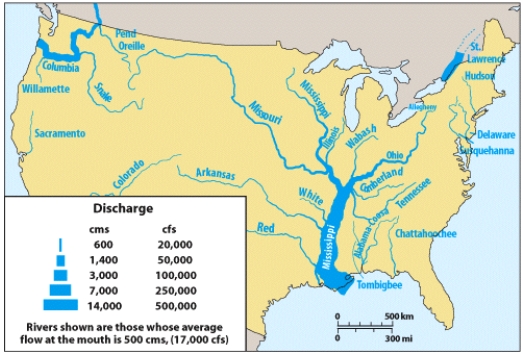
A)Atlantic
B)Pacific
C)Interior
D)Gulf of Mexico
E)none of the above
A)Atlantic
B)Pacific
C)Interior
D)Gulf of Mexico
E)none of the above
سؤال
The feature pictured below is formed as a result of subsurface dissolution of limestone rock which can weaken the overlying material and cause it to collapse. These resulting features are called: 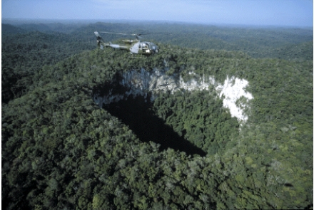
A)caves
B)sinkholes
C)aquifers
D)geysers
E)artesian wells
A)caves
B)sinkholes
C)aquifers
D)geysers
E)artesian wells
سؤال
سؤال
سؤال
سؤال
سؤال
سؤال
سؤال
سؤال
According to the figure below, how many total internally drained basins are represented. 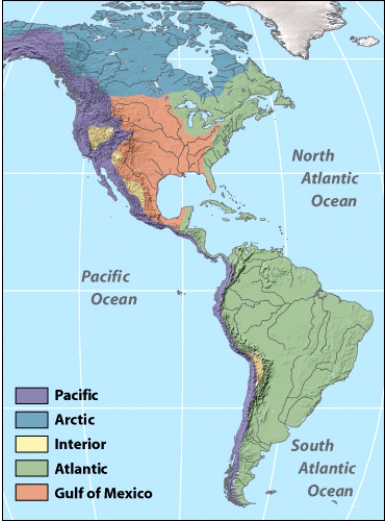
A)1
B)2
C)3
D)4
E)5
A)1
B)2
C)3
D)4
E)5
سؤال
سؤال
سؤال
سؤال
سؤال
سؤال
سؤال
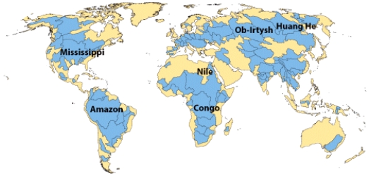
According to the figure below, which of the following rivers are tributaries to the Mississippi? 
A)Ohio River
B)Missouri River
C)Columbia River
D)all of the above
E)A & B only
A)Ohio River
B)Missouri River
C)Columbia River
D)all of the above
E)A & B only
سؤال
In the figure below, the Mississippi River discharge is greatest near the mouth.

سؤال
سؤال
سؤال
سؤال
The figure below was formed by what part of the water cycle. 
A)oceans
B)atmosphere
C)ground water
D)ice
E)streams
A)oceans
B)atmosphere
C)ground water
D)ice
E)streams
سؤال
سؤال
سؤال
سؤال
سؤال
سؤال
سؤال
According to the figure below, over which four month interval does the base flow of the Chattahoochee River have the highest discharge? 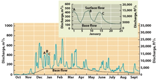
A)Sept.-Oct.-Nov.-Dec.
B)Jan.-Feb.-Mar.-Apr.
C)May-Jun.-July.-Aug.
D)Nov.-Dec.-Jan.-Feb.
E)Mar.-Apr.-May-Jun.
A)Sept.-Oct.-Nov.-Dec.
B)Jan.-Feb.-Mar.-Apr.
C)May-Jun.-July.-Aug.
D)Nov.-Dec.-Jan.-Feb.
E)Mar.-Apr.-May-Jun.
سؤال
سؤال
سؤال
سؤال
سؤال
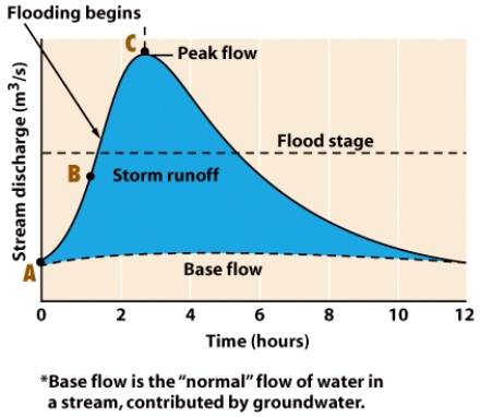
According to the figure below, how long did the river's discharge exceed flood stage? 
A)1 hour
B)2 hours
C)3 hours
D)4 hours
E)5 hours
A)1 hour
B)2 hours
C)3 hours
D)4 hours
E)5 hours
سؤال
سؤال
سؤال
سؤال
سؤال
سؤال
سؤال
سؤال
According to the figure below, peak flow of a flood occurs approximately __________ hours after flooding begins.
سؤال
سؤال
سؤال
__________ is the continent with the lowest amount of watersheds.
سؤال
سؤال
سؤال
سؤال
The figure below illustrates the result of good water management.
سؤال
سؤال
سؤال
سؤال
سؤال
سؤال
سؤال
سؤال
سؤال
سؤال
سؤال
سؤال
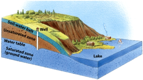
In the figure below, describe what might happen to the lake level if the water table was drawn down significantly by ground water pumping in the well.
سؤال
سؤال
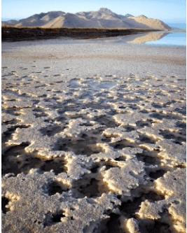
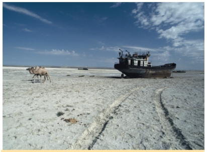
Use the image below to describe the types of environmental changes that appear to be occurring in this region of the Aral Sea. Use what you have learned in this chapter to strengthen your points.
سؤال

فتح الحزمة
قم بالتسجيل لفتح البطاقات في هذه المجموعة!
Unlock Deck
Unlock Deck
1/67
العب
ملء الشاشة (f)
Deck 11: Fresh Water of the Continents
1
Which of the following is true of a karst landscape?
A)carbonate bedrock is present
B)sinkholes are common
C)ground water travels through cave systems
D)none of these
E)all of these
A)carbonate bedrock is present
B)sinkholes are common
C)ground water travels through cave systems
D)none of these
E)all of these
E
2
According to the figure below, South America has very small amount of __________ drainage along its western coast.
A)Atlantic
B)Pacific
C)Interior
D)Gulf of Mexico
E)none of the above
A)Atlantic
B)Pacific
C)Interior
D)Gulf of Mexico
E)none of the above
B
3
A(n)__________ occurs in an area where the ground water is heated by hot rock near the surface which can force the ground water to flow out under pressure.
A)aquifer
B)aquiclude
C)oxbow lake
D)geyser
E)ocean
A)aquifer
B)aquiclude
C)oxbow lake
D)geyser
E)ocean
D
4
According to the figure below, the Ohio River eventually drains into what body of water?
A)Atlantic
B)Pacific
C)Interior
D)Gulf of Mexico
E)none of the above
A)Atlantic
B)Pacific
C)Interior
D)Gulf of Mexico
E)none of the above
فتح الحزمة
افتح القفل للوصول البطاقات البالغ عددها 67 في هذه المجموعة.
فتح الحزمة
k this deck
5
The feature pictured below is formed as a result of subsurface dissolution of limestone rock which can weaken the overlying material and cause it to collapse. These resulting features are called:
A)caves
B)sinkholes
C)aquifers
D)geysers
E)artesian wells
A)caves
B)sinkholes
C)aquifers
D)geysers
E)artesian wells
فتح الحزمة
افتح القفل للوصول البطاقات البالغ عددها 67 في هذه المجموعة.
فتح الحزمة
k this deck
6
Water from precipitation sinks into the soil and flows downward through the soil-water belt under the force of gravity is a process called __________.
A)permeability
B)porosity
C)recharge
D)infiltration
E)percolation
A)permeability
B)porosity
C)recharge
D)infiltration
E)percolation
فتح الحزمة
افتح القفل للوصول البطاقات البالغ عددها 67 في هذه المجموعة.
فتح الحزمة
k this deck
7
The drainage pattern that has a pattern that looks like a branching tree is called:
A)dendritic
B)trellis
C)annular
D)radial
A)dendritic
B)trellis
C)annular
D)radial
فتح الحزمة
افتح القفل للوصول البطاقات البالغ عددها 67 في هذه المجموعة.
فتح الحزمة
k this deck
8
Perfect symmetrical cone type volcanoes would have what type of drainage pattern?
A)dendritic
B)trellis
C)annular
D)radial
A)dendritic
B)trellis
C)annular
D)radial
فتح الحزمة
افتح القفل للوصول البطاقات البالغ عددها 67 في هذه المجموعة.
فتح الحزمة
k this deck
9
Subsurface water contained in pore spaces in regolith and bedrock is known as __________.
A)water table
B)ground water
C)aquifer
D)aquiclude
E)transpiration
A)water table
B)ground water
C)aquifer
D)aquiclude
E)transpiration
فتح الحزمة
افتح القفل للوصول البطاقات البالغ عددها 67 في هذه المجموعة.
فتح الحزمة
k this deck
10
The drainage pattern that you would find along a dome shape rock would be:
A)dendritic
B)trellis
C)annular
D)radial
A)dendritic
B)trellis
C)annular
D)radial
فتح الحزمة
افتح القفل للوصول البطاقات البالغ عددها 67 في هذه المجموعة.
فتح الحزمة
k this deck
11
Precipitation that does not evapotranspirate or infiltrate once it hits the ground surface contributes to:
A)ground water recharge
B)surface water runoff
C)aquifer development
D)clouds formation
E)none of these
A)ground water recharge
B)surface water runoff
C)aquifer development
D)clouds formation
E)none of these
فتح الحزمة
افتح القفل للوصول البطاقات البالغ عددها 67 في هذه المجموعة.
فتح الحزمة
k this deck
12
In moist climates, __________ tends to dissolve limestone near the surface, resulting in cave formation.
A)hydrochloric acid
B)citric acid
C)carbonic acid
D)phosphoric acid
E)none of these
A)hydrochloric acid
B)citric acid
C)carbonic acid
D)phosphoric acid
E)none of these
فتح الحزمة
افتح القفل للوصول البطاقات البالغ عددها 67 في هذه المجموعة.
فتح الحزمة
k this deck
13
According to the figure below, how many total internally drained basins are represented.
A)1
B)2
C)3
D)4
E)5
A)1
B)2
C)3
D)4
E)5
فتح الحزمة
افتح القفل للوصول البطاقات البالغ عددها 67 في هذه المجموعة.
فتح الحزمة
k this deck
14
The process in which water changes from a liquid to a vapor is known as __________.
A)transpiration
B)evaporation
C)compaction
D)condensation
E)infiltration
A)transpiration
B)evaporation
C)compaction
D)condensation
E)infiltration
فتح الحزمة
افتح القفل للوصول البطاقات البالغ عددها 67 في هذه المجموعة.
فتح الحزمة
k this deck
15
The ridge and valley system of Appalachia which has parallel hills and valleys would have which type of drainage pattern?
A)dendritic
B)trellis
C)annular
D)radial
A)dendritic
B)trellis
C)annular
D)radial
فتح الحزمة
افتح القفل للوصول البطاقات البالغ عددها 67 في هذه المجموعة.
فتح الحزمة
k this deck
16
Late summertime base flow in a stream is typically maintained by:
A)rainfall
B)snowmelt
C)groundwater discharge
D)evaporation
E)high tide
A)rainfall
B)snowmelt
C)groundwater discharge
D)evaporation
E)high tide
فتح الحزمة
افتح القفل للوصول البطاقات البالغ عددها 67 في هذه المجموعة.
فتح الحزمة
k this deck
17
Which of the following conditions would be most consistent with the characteristics of a good aquifer?
A)high porosity and high permeability
B)high porosity and low permeability
C)low porosity and high permeability
D)low porosity and low permeability
E)not enough information to determine
A)high porosity and high permeability
B)high porosity and low permeability
C)low porosity and high permeability
D)low porosity and low permeability
E)not enough information to determine
فتح الحزمة
افتح القفل للوصول البطاقات البالغ عددها 67 في هذه المجموعة.
فتح الحزمة
k this deck
18
___________ occurs when plants intercept water and release it back into the atmosphere.
A)transpiration
B)evaporation
C)compaction
D)condensation
E)infiltration
A)transpiration
B)evaporation
C)compaction
D)condensation
E)infiltration
فتح الحزمة
افتح القفل للوصول البطاقات البالغ عددها 67 في هذه المجموعة.
فتح الحزمة
k this deck
19
A body of rock or regolith that is water-saturated, porous, and permeable is known as a(n)__________.
A)aquiclude
B)aquifer
C)aquitard
D)oxbow lake
E)spring
A)aquiclude
B)aquifer
C)aquitard
D)oxbow lake
E)spring
فتح الحزمة
افتح القفل للوصول البطاقات البالغ عددها 67 في هذه المجموعة.
فتح الحزمة
k this deck
20
According to the figure below, which of the following rivers are tributaries to the Mississippi?
A)Ohio River
B)Missouri River
C)Columbia River
D)all of the above
E)A & B only
A)Ohio River
B)Missouri River
C)Columbia River
D)all of the above
E)A & B only
فتح الحزمة
افتح القفل للوصول البطاقات البالغ عددها 67 في هذه المجموعة.
فتح الحزمة
k this deck
21
In the figure below, the Mississippi River discharge is greatest near the mouth.
فتح الحزمة
افتح القفل للوصول البطاقات البالغ عددها 67 في هذه المجموعة.
فتح الحزمة
k this deck
22
A ____________ will typically develop around a well when the rate of pumping exceeds the rate of recharge.
A)zone of saturation
B)rising water table
C)spring
D)cone of depression
E)surplus of water
A)zone of saturation
B)rising water table
C)spring
D)cone of depression
E)surplus of water
فتح الحزمة
افتح القفل للوصول البطاقات البالغ عددها 67 في هذه المجموعة.
فتح الحزمة
k this deck
23
The water table is at the top of the __________.
A)zone of saturation
B)zone of aeration
C)zone of recharge
D)zone of discharge
E)none of these
A)zone of saturation
B)zone of aeration
C)zone of recharge
D)zone of discharge
E)none of these
فتح الحزمة
افتح القفل للوصول البطاقات البالغ عددها 67 في هذه المجموعة.
فتح الحزمة
k this deck
24
Which of the following variables influences the discharge of a stream?
A)gradient
B)drainage area
C)rainfall
D)all of these
E)none of these
A)gradient
B)drainage area
C)rainfall
D)all of these
E)none of these
فتح الحزمة
افتح القفل للوصول البطاقات البالغ عددها 67 في هذه المجموعة.
فتح الحزمة
k this deck
25
The figure below was formed by what part of the water cycle.
A)oceans
B)atmosphere
C)ground water
D)ice
E)streams
A)oceans
B)atmosphere
C)ground water
D)ice
E)streams
فتح الحزمة
افتح القفل للوصول البطاقات البالغ عددها 67 في هذه المجموعة.
فتح الحزمة
k this deck
26
The flat areas adjacent to the edges of a stream channel where agricultural crops are often developed are referred to as:
A)floodplains
B)levees
C)flash floods
D)meander bends
E)lakes
A)floodplains
B)levees
C)flash floods
D)meander bends
E)lakes
فتح الحزمة
افتح القفل للوصول البطاقات البالغ عددها 67 في هذه المجموعة.
فتح الحزمة
k this deck
27
In arid landscapes, lakes are often internally drained, and as a result of ____________, leave behind accumulations of salts.
A)excess rainfall
B)groundwater discharge
C)infiltration
D)evaporation
E)tidal changes
A)excess rainfall
B)groundwater discharge
C)infiltration
D)evaporation
E)tidal changes
فتح الحزمة
افتح القفل للوصول البطاقات البالغ عددها 67 في هذه المجموعة.
فتح الحزمة
k this deck
28
The replenishment of groundwater is known as __________.
A)discharge
B)recharge
C)runoff
D)eutrophication
E)porosity
A)discharge
B)recharge
C)runoff
D)eutrophication
E)porosity
فتح الحزمة
افتح القفل للوصول البطاقات البالغ عددها 67 في هذه المجموعة.
فتح الحزمة
k this deck
29
A subsurface rock layer that is composed of clay and represents a barrier to flow would be described as a(n):
A)aquiclude
B)aquifer
C)geyser
D)oxbow lake
E)spring
A)aquiclude
B)aquifer
C)geyser
D)oxbow lake
E)spring
فتح الحزمة
افتح القفل للوصول البطاقات البالغ عددها 67 في هذه المجموعة.
فتح الحزمة
k this deck
30
The spring of 2011 saw epic flooding along which river? Damage estimates for the total economic cost ranged as high as $7-9 billion making this one of the worst floods to occur in the past 100 years.
A)Columbia
B)Ohio
C)Mississippi
D)Missouri
A)Columbia
B)Ohio
C)Mississippi
D)Missouri
فتح الحزمة
افتح القفل للوصول البطاقات البالغ عددها 67 في هذه المجموعة.
فتح الحزمة
k this deck
31
The process that separates fresh water from sea water, offers an additional source of fresh water in locations lacking sufficient precipitation is known as:
A)desalination
B)eutrophication
C)ground water extraction
D)none of the above
A)desalination
B)eutrophication
C)ground water extraction
D)none of the above
فتح الحزمة
افتح القفل للوصول البطاقات البالغ عددها 67 في هذه المجموعة.
فتح الحزمة
k this deck
32
According to the figure below, over which four month interval does the base flow of the Chattahoochee River have the highest discharge?
A)Sept.-Oct.-Nov.-Dec.
B)Jan.-Feb.-Mar.-Apr.
C)May-Jun.-July.-Aug.
D)Nov.-Dec.-Jan.-Feb.
E)Mar.-Apr.-May-Jun.
A)Sept.-Oct.-Nov.-Dec.
B)Jan.-Feb.-Mar.-Apr.
C)May-Jun.-July.-Aug.
D)Nov.-Dec.-Jan.-Feb.
E)Mar.-Apr.-May-Jun.
فتح الحزمة
افتح القفل للوصول البطاقات البالغ عددها 67 في هذه المجموعة.
فتح الحزمة
k this deck
33
In which part of a straight stream channel is the water moving fastest?
A)along the stream bed
B)in the middle of the stream channel near the surface
C)along the right edge of a stream channel
D)along the left edge of the stream channel
E)where the stream channel is the deepest
A)along the stream bed
B)in the middle of the stream channel near the surface
C)along the right edge of a stream channel
D)along the left edge of the stream channel
E)where the stream channel is the deepest
فتح الحزمة
افتح القفل للوصول البطاقات البالغ عددها 67 في هذه المجموعة.
فتح الحزمة
k this deck
34
The hydrologic cycle does not include atmospheric processes.
فتح الحزمة
افتح القفل للوصول البطاقات البالغ عددها 67 في هذه المجموعة.
فتح الحزمة
k this deck
35
Which of the following would be considered surface water pollution if found in anomalously high concentrations?
A)nitrates
B)mercury
C)hot water
D)all of these
E)none of these
A)nitrates
B)mercury
C)hot water
D)all of these
E)none of these
فتح الحزمة
افتح القفل للوصول البطاقات البالغ عددها 67 في هذه المجموعة.
فتح الحزمة
k this deck
36
A __________ is a topographic high that separates adjacent drainage basins.
A)spring
B)reservoir lake
C)delta
D)divide
E)gradient
A)spring
B)reservoir lake
C)delta
D)divide
E)gradient
فتح الحزمة
افتح القفل للوصول البطاقات البالغ عددها 67 في هذه المجموعة.
فتح الحزمة
k this deck
37
According to the figure below, how long did the river's discharge exceed flood stage?
A)1 hour
B)2 hours
C)3 hours
D)4 hours
E)5 hours
A)1 hour
B)2 hours
C)3 hours
D)4 hours
E)5 hours
فتح الحزمة
افتح القفل للوصول البطاقات البالغ عددها 67 في هذه المجموعة.
فتح الحزمة
k this deck
38
Lakes can be man-made or natural features in the landscape. Which of the following would you consider true about lakes?
A)lakes are only composed of freshwater
B)lakes provide recreational opportunities
C)lakes can help produce electricity
D)all of the above
E)B & C only
A)lakes are only composed of freshwater
B)lakes provide recreational opportunities
C)lakes can help produce electricity
D)all of the above
E)B & C only
فتح الحزمة
افتح القفل للوصول البطاقات البالغ عددها 67 في هذه المجموعة.
فتح الحزمة
k this deck
39
The process in which water has condensed in the atmosphere and falls back to Earth is known as __________.
A)transpiration
B)evaporation
C)precipitation
D)condensation
E)infiltration
A)transpiration
B)evaporation
C)precipitation
D)condensation
E)infiltration
فتح الحزمة
افتح القفل للوصول البطاقات البالغ عددها 67 في هذه المجموعة.
فتح الحزمة
k this deck
40
A system of low discharge streams that join a larger discharge trunk stream as water travels down-gradient are typically referred to as:
A)springs
B)lakes
C)deltas
D)tributaries
E)meanders
A)springs
B)lakes
C)deltas
D)tributaries
E)meanders
فتح الحزمة
افتح القفل للوصول البطاقات البالغ عددها 67 في هذه المجموعة.
فتح الحزمة
k this deck
41
In many parts of the world, one of the primary uses of surface water is to help produce electric power.
فتح الحزمة
افتح القفل للوصول البطاقات البالغ عددها 67 في هذه المجموعة.
فتح الحزمة
k this deck
42
Precipitation is the process in which water flows into the ground under the influence of gravity.
فتح الحزمة
افتح القفل للوصول البطاقات البالغ عددها 67 في هذه المجموعة.
فتح الحزمة
k this deck
43
An aquifer in which the water is allowed to rise to its natural level is known as a confined aquifer.
فتح الحزمة
افتح القفل للوصول البطاقات البالغ عددها 67 في هذه المجموعة.
فتح الحزمة
k this deck
44
Precipitation that flows over the land in stream channels is commonly referred to as __________.
فتح الحزمة
افتح القفل للوصول البطاقات البالغ عددها 67 في هذه المجموعة.
فتح الحزمة
k this deck
45
According to the figure below, peak flow of a flood occurs approximately __________ hours after flooding begins.
فتح الحزمة
افتح القفل للوصول البطاقات البالغ عددها 67 في هذه المجموعة.
فتح الحزمة
k this deck
46
__________ refers to the amount of void space in a rock.
فتح الحزمة
افتح القفل للوصول البطاقات البالغ عددها 67 في هذه المجموعة.
فتح الحزمة
k this deck
47
The pore spaces within the unsaturated zone are above the water table and are not full of water.
فتح الحزمة
افتح القفل للوصول البطاقات البالغ عددها 67 في هذه المجموعة.
فتح الحزمة
k this deck
48
__________ is the continent with the lowest amount of watersheds.
فتح الحزمة
افتح القفل للوصول البطاقات البالغ عددها 67 في هذه المجموعة.
فتح الحزمة
k this deck
49
The water table is located at the top of the zone of saturation.
فتح الحزمة
افتح القفل للوصول البطاقات البالغ عددها 67 في هذه المجموعة.
فتح الحزمة
k this deck
50
The __________ is below the water table in which all the pore spaces are filled with water.
فتح الحزمة
افتح القفل للوصول البطاقات البالغ عددها 67 في هذه المجموعة.
فتح الحزمة
k this deck
51
The total area from which water flows into a stream is known as the drainage basin.
فتح الحزمة
افتح القفل للوصول البطاقات البالغ عددها 67 في هذه المجموعة.
فتح الحزمة
k this deck
52
The figure below illustrates the result of good water management.
فتح الحزمة
افتح القفل للوصول البطاقات البالغ عددها 67 في هذه المجموعة.
فتح الحزمة
k this deck
53
Caves and caverns actually become smaller in size over time.
فتح الحزمة
افتح القفل للوصول البطاقات البالغ عددها 67 في هذه المجموعة.
فتح الحزمة
k this deck
54
The term __________ refers to the amount of water passing a point on the stream's bank during a given unit of time.
فتح الحزمة
افتح القفل للوصول البطاقات البالغ عددها 67 في هذه المجموعة.
فتح الحزمة
k this deck
55
__________ topography is characterized by many sinkholes and disrupted drainage patterns.
فتح الحزمة
افتح القفل للوصول البطاقات البالغ عددها 67 في هذه المجموعة.
فتح الحزمة
k this deck
56
Transpiration is the process in which plants take in water and pass it directly into the atmosphere.
فتح الحزمة
افتح القفل للوصول البطاقات البالغ عددها 67 في هذه المجموعة.
فتح الحزمة
k this deck
57
A dip that forms in the water table as a result of pumping is known as a cone of depression.
فتح الحزمة
افتح القفل للوصول البطاقات البالغ عددها 67 في هذه المجموعة.
فتح الحزمة
k this deck
58
Stalactites are carbonate deposits that commonly occur on the floors of caves.
فتح الحزمة
افتح القفل للوصول البطاقات البالغ عددها 67 في هذه المجموعة.
فتح الحزمة
k this deck
59
Most fresh water is actually found in __________ across the globe.
فتح الحزمة
افتح القفل للوصول البطاقات البالغ عددها 67 في هذه المجموعة.
فتح الحزمة
k this deck
60
Eutrophication can occur when sewage and fertilizers are introduced into a lake.
فتح الحزمة
افتح القفل للوصول البطاقات البالغ عددها 67 في هذه المجموعة.
فتح الحزمة
k this deck
61
What is the hydrologic cycle?
فتح الحزمة
افتح القفل للوصول البطاقات البالغ عددها 67 في هذه المجموعة.
فتح الحزمة
k this deck
62
What is a cone of depression?
فتح الحزمة
افتح القفل للوصول البطاقات البالغ عددها 67 في هذه المجموعة.
فتح الحزمة
k this deck
63
What is the difference between the saturated zone and the unsaturated zone?
فتح الحزمة
افتح القفل للوصول البطاقات البالغ عددها 67 في هذه المجموعة.
فتح الحزمة
k this deck
64
In the figure below, describe what might happen to the lake level if the water table was drawn down significantly by ground water pumping in the well.
فتح الحزمة
افتح القفل للوصول البطاقات البالغ عددها 67 في هذه المجموعة.
فتح الحزمة
k this deck
65
A layer of rock or sediment that contains abundant freely flowing ground water is known as a(n)_____________.
فتح الحزمة
افتح القفل للوصول البطاقات البالغ عددها 67 في هذه المجموعة.
فتح الحزمة
k this deck
66
Use the image below to describe the types of environmental changes that appear to be occurring in this region of the Aral Sea. Use what you have learned in this chapter to strengthen your points.
فتح الحزمة
افتح القفل للوصول البطاقات البالغ عددها 67 في هذه المجموعة.
فتح الحزمة
k this deck
67
____________ is the drainage pattern that resembles a tree branch and usually goes more in a random direction compared to any of the other type of patterns.
فتح الحزمة
افتح القفل للوصول البطاقات البالغ عددها 67 في هذه المجموعة.
فتح الحزمة
k this deck
فتح الحزمة
افتح القفل للوصول البطاقات البالغ عددها 67 في هذه المجموعة.


