Deck 14: Glacial and Periglacial Landforms
ملء الشاشة (f)
سؤال
سؤال
سؤال
سؤال
سؤال
سؤال
سؤال
سؤال
سؤال
سؤال
سؤال
سؤال
سؤال
سؤال
سؤال
سؤال
سؤال
سؤال
سؤال
سؤال
سؤال
سؤال
سؤال
سؤال
سؤال
سؤال
سؤال
سؤال
سؤال
سؤال
سؤال
سؤال
سؤال
سؤال
سؤال
سؤال
سؤال
سؤال
سؤال
سؤال
سؤال
سؤال
سؤال
سؤال
سؤال
سؤال
سؤال
سؤال
The landform at A is a(n): 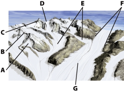
A)arête
B)horn
C)cirque
D)trough
A)arête
B)horn
C)cirque
D)trough
سؤال
The landform at C is a(n): 
A)horn
B)kame
C)inselberg
D)drumlin
A)horn
B)kame
C)inselberg
D)drumlin
سؤال
سؤال
سؤال
سؤال
سؤال
سؤال
On the illustration, the landforms at B are: 
A)arêtes
B)eskers
C)medial moraine
D)drumlins
A)arêtes
B)eskers
C)medial moraine
D)drumlins
سؤال
The landform at G is a(n): 
A)lateral moraine
B)esker
C)medial moraine
D)drumlin
A)lateral moraine
B)esker
C)medial moraine
D)drumlin
سؤال
سؤال
سؤال
On the illustration, the landforms at A are: 
A)arêtes
B)kettles
C)horns
D)drumlins
A)arêtes
B)kettles
C)horns
D)drumlins
سؤال
سؤال
On the illustration, the landform at L is a(n): 
A)pediment
B)till plain
C)outwash plain
D)floodplain
A)pediment
B)till plain
C)outwash plain
D)floodplain
سؤال
سؤال
On the illustration, the landform at K is a(n): 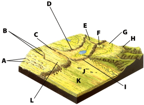
A)outwash plain
B)till plain
C)floodplain
D)pediment
A)outwash plain
B)till plain
C)floodplain
D)pediment
سؤال
سؤال
سؤال
سؤال
سؤال
سؤال
On the illustration, the landform at D is a(n): 
A)recessional moraine
B)interlobate moraine
C)terminal moraine
D)esker
A)recessional moraine
B)interlobate moraine
C)terminal moraine
D)esker
سؤال
سؤال
سؤال
On the illustration, land that was NOT beneath the ice is found at: 
A)A
B)L
C)K
D)E
A)A
B)L
C)K
D)E
سؤال
سؤال
سؤال
سؤال
On the illustration, the landform at E is a(n): 
A)arête
B)recessional moraine
C)terminal moraine
D)esker
A)arête
B)recessional moraine
C)terminal moraine
D)esker
سؤال
سؤال
سؤال
سؤال
On the illustration, the landform at I is a(n): 
A)terminal moraine
B)recessional moraine
C)ground moraine
D)lateral moraine
A)terminal moraine
B)recessional moraine
C)ground moraine
D)lateral moraine

فتح الحزمة
قم بالتسجيل لفتح البطاقات في هذه المجموعة!
Unlock Deck
Unlock Deck
1/105
العب
ملء الشاشة (f)
Deck 14: Glacial and Periglacial Landforms
1
Glaciers usually result in areas of:
A)high elevations and high latitudes
B)low elevations and low latitudes
C)low precipitation and low latitudes
D)high precipitation and low latitudes
A)high elevations and high latitudes
B)low elevations and low latitudes
C)low precipitation and low latitudes
D)high precipitation and low latitudes
A
2
Conditions that permit glacial formation include:
A)low elevations
B)high mean temperatures
C)high annual rainfall
D)more snow persisting than melting
A)low elevations
B)high mean temperatures
C)high annual rainfall
D)more snow persisting than melting
D
3
Alpine glaciers form by:
A)freezing in streams in mountain valleys
B)accumulation of snow in stream valleys
C)compaction and accumulation of snow near the top of mountains
D)accumulation of hail mixed with sleet below the snow line
A)freezing in streams in mountain valleys
B)accumulation of snow in stream valleys
C)compaction and accumulation of snow near the top of mountains
D)accumulation of hail mixed with sleet below the snow line
C
4
When the troughs of tributary glaciers lie above sea level, these hanging valleys can create:
A)kames and kettles
B)natural levees
C)waterfalls and rapids
D)mesas and buttes
A)kames and kettles
B)natural levees
C)waterfalls and rapids
D)mesas and buttes
فتح الحزمة
افتح القفل للوصول البطاقات البالغ عددها 105 في هذه المجموعة.
فتح الحزمة
k this deck
5
The outer most or lowest end of a glacier is called its:
A)headwall
B)surge
C)col
D)terminus
A)headwall
B)surge
C)col
D)terminus
فتح الحزمة
افتح القفل للوصول البطاقات البالغ عددها 105 في هذه المجموعة.
فتح الحزمة
k this deck
6
Where exposed cirques have intersected deeply, a notch is formed. This is called a/an:
A)kame
B)inselberg
C)col
D)esker
A)kame
B)inselberg
C)col
D)esker
فتح الحزمة
افتح القفل للوصول البطاقات البالغ عددها 105 في هذه المجموعة.
فتح الحزمة
k this deck
7
A large, thick plate of glacial ice moving outwards in all directions is a(n):
A)alpine glacier
B)iceberg
C)ice sheet
D)inselberg
A)alpine glacier
B)iceberg
C)ice sheet
D)inselberg
فتح الحزمة
افتح القفل للوصول البطاقات البالغ عددها 105 في هذه المجموعة.
فتح الحزمة
k this deck
8
A deep, steep-sided rock trench formed by erosion from alpine glaciers is a(n):
A)arête
B)horn
C)moraine
D)glacial trough
A)arête
B)horn
C)moraine
D)glacial trough
فتح الحزمة
افتح القفل للوصول البطاقات البالغ عددها 105 في هذه المجموعة.
فتح الحزمة
k this deck
9
A narrow, deep ocean inlet that partially fills a glacial trough is a/an:
A)cirque
B)fiord
C)col
D)outwash plain
A)cirque
B)fiord
C)col
D)outwash plain
فتح الحزمة
افتح القفل للوصول البطاقات البالغ عددها 105 في هذه المجموعة.
فتح الحزمة
k this deck
10
Alpine glaciers are generally:
A)broad and flat
B)long and narrow
C)thick and triangular
D)thin and round
A)broad and flat
B)long and narrow
C)thick and triangular
D)thin and round
فتح الحزمة
افتح القفل للوصول البطاقات البالغ عددها 105 في هذه المجموعة.
فتح الحزمة
k this deck
11
The melting of a glacier results in:
A)metamorphic rock
B)ventifacts
C)meltwater
D)firn
A)metamorphic rock
B)ventifacts
C)meltwater
D)firn
فتح الحزمة
افتح القفل للوصول البطاقات البالغ عددها 105 في هذه المجموعة.
فتح الحزمة
k this deck
12
A debris ridge along either side of a trough of an alpine glacier is a(n):
A)arête
B)terminal moraine
C)col
D)lateral moraine
A)arête
B)terminal moraine
C)col
D)lateral moraine
فتح الحزمة
افتح القفل للوصول البطاقات البالغ عددها 105 في هذه المجموعة.
فتح الحزمة
k this deck
13
Glaciers move because:
A)the cold ice is more dense and wind currents make it sink
B)the pressure at the bottom of the ice mass makes it lose its rigidity, then it moves with gravity
C)the wind blows the snow
D)ground water pushes it from below while the Coriolis effect acts to deflect the movement
A)the cold ice is more dense and wind currents make it sink
B)the pressure at the bottom of the ice mass makes it lose its rigidity, then it moves with gravity
C)the wind blows the snow
D)ground water pushes it from below while the Coriolis effect acts to deflect the movement
فتح الحزمة
افتح القفل للوصول البطاقات البالغ عددها 105 في هذه المجموعة.
فتح الحزمة
k this deck
14
The grinding and scratching of rock fragments carried by a glacier against rocks or other fragments is called:
A)abrasion
B)plucking
C)calving
D)retreating
A)abrasion
B)plucking
C)calving
D)retreating
فتح الحزمة
افتح القفل للوصول البطاقات البالغ عددها 105 في هذه المجموعة.
فتح الحزمة
k this deck
15
A glacier that forms in a mountainous area is called a(n):
A)alpine glacier
B)iceberg
C)ice sheet
D)inselberg
A)alpine glacier
B)iceberg
C)ice sheet
D)inselberg
فتح الحزمة
افتح القفل للوصول البطاقات البالغ عددها 105 في هذه المجموعة.
فتح الحزمة
k this deck
16
Glaciers erode landscapes by:
A)lithification
B)solution
C)saltation
D)abrasion
A)lithification
B)solution
C)saltation
D)abrasion
فتح الحزمة
افتح القفل للوصول البطاقات البالغ عددها 105 في هذه المجموعة.
فتح الحزمة
k this deck
17
Today's ice sheets, or continental glaciers, are restricted to Antarctica and where?
A)Greenland
B)Iceland
C)Chile
D)Norway
A)Greenland
B)Iceland
C)Chile
D)Norway
فتح الحزمة
افتح القفل للوصول البطاقات البالغ عددها 105 في هذه المجموعة.
فتح الحزمة
k this deck
18
A lake that forms in the depression at the bottom of a cirque of an alpine glacier is a(n):
A)kame
B)sinkhole
C)col
D)tarn
A)kame
B)sinkhole
C)col
D)tarn
فتح الحزمة
افتح القفل للوصول البطاقات البالغ عددها 105 في هذه المجموعة.
فتح الحزمة
k this deck
19
Any large natural accumulation of land ice affected by present or past motion is a(n):
A)iceberg
B)moraine
C)glacier
D)horn
A)iceberg
B)moraine
C)glacier
D)horn
فتح الحزمة
افتح القفل للوصول البطاقات البالغ عددها 105 في هذه المجموعة.
فتح الحزمة
k this deck
20
Alpine glaciers originate from a snowfield that has collected in a bowl-shaped depression called a:
A)tarn
B)horn
C)cirque
D)drumlin
A)tarn
B)horn
C)cirque
D)drumlin
فتح الحزمة
افتح القفل للوصول البطاقات البالغ عددها 105 في هذه المجموعة.
فتح الحزمة
k this deck
21
Sorted and layered materials deposited by a glacier are BEST called:
A)alluvium
B)bedrock
C)moraine
D)stratified drift
A)alluvium
B)bedrock
C)moraine
D)stratified drift
فتح الحزمة
افتح القفل للوصول البطاقات البالغ عددها 105 في هذه المجموعة.
فتح الحزمة
k this deck
22
When the amount of melting equals the amount of accumulation, the glacier is in equilibrium and is
A)advancing
B)retreating
C)stationary
D)stagnant
A)advancing
B)retreating
C)stationary
D)stagnant
فتح الحزمة
افتح القفل للوصول البطاقات البالغ عددها 105 في هذه المجموعة.
فتح الحزمة
k this deck
23
When intersecting cirques carve away the mountain, narrow, sharp ridges called what are formed?
A)arêtes
B)medial moraines
C)lateral moraines
D)eskers
A)arêtes
B)medial moraines
C)lateral moraines
D)eskers
فتح الحزمة
افتح القفل للوصول البطاقات البالغ عددها 105 في هذه المجموعة.
فتح الحزمة
k this deck
24
The ridge of material that collects at the farthest advance of the glacier is the:
A)lateral moraine
B)recessional moraine
C)terminal moraine
D)esker
A)lateral moraine
B)recessional moraine
C)terminal moraine
D)esker
فتح الحزمة
افتح القفل للوصول البطاقات البالغ عددها 105 في هذه المجموعة.
فتح الحزمة
k this deck
25
A thin layer of till that blankets the landscape after a glacier melts is called:
A)melt-out till
B)lodgement till
C)medial moraine
D)terminal moraine
A)melt-out till
B)lodgement till
C)medial moraine
D)terminal moraine
فتح الحزمة
افتح القفل للوصول البطاقات البالغ عددها 105 في هذه المجموعة.
فتح الحزمة
k this deck
26
Sea ice is associated with:
A)central Antarctica
B)Hawaii
C)the North Pole
D)the Mediterranean Sea
A)central Antarctica
B)Hawaii
C)the North Pole
D)the Mediterranean Sea
فتح الحزمة
افتح القفل للوصول البطاقات البالغ عددها 105 في هذه المجموعة.
فتح الحزمة
k this deck
27
The main depositional landforms found along alpine glaciers are:
A)horns
B)kames
C)cirques
D)moraines
A)horns
B)kames
C)cirques
D)moraines
فتح الحزمة
افتح القفل للوصول البطاقات البالغ عددها 105 في هذه المجموعة.
فتح الحزمة
k this deck
28
The two types of glacial drift are BEST called:
A)alluvium and moraine
B)stratified drift and till
C)alluvium and loess
D)moraine and regolith
A)alluvium and moraine
B)stratified drift and till
C)alluvium and loess
D)moraine and regolith
فتح الحزمة
افتح القفل للوصول البطاقات البالغ عددها 105 في هذه المجموعة.
فتح الحزمة
k this deck
29
Beyond the moraine, a smooth area of water-laid sediment often marked by kettles and kames, is called a/an:
A)outwash plain
B)pediment
C)mesa
D)terminal moraine
A)outwash plain
B)pediment
C)mesa
D)terminal moraine
فتح الحزمة
افتح القفل للوصول البطاقات البالغ عددها 105 في هذه المجموعة.
فتح الحزمة
k this deck
30
Oval or spoon-shaped hills that form in groups beneath an ice sheet glacier and indicate the direction of movement are:
A)arêtes
B)kames
C)eskers
D)drumlins
A)arêtes
B)kames
C)eskers
D)drumlins
فتح الحزمة
افتح القفل للوصول البطاقات البالغ عددها 105 في هذه المجموعة.
فتح الحزمة
k this deck
31
Great plates of floating ice on a continental glacier are:
A)ice shelves
B)inselbergs
C)outwash plains
D)drumlins
A)ice shelves
B)inselbergs
C)outwash plains
D)drumlins
فتح الحزمة
افتح القفل للوصول البطاقات البالغ عددها 105 في هذه المجموعة.
فتح الحزمة
k this deck
32
When intersecting cirques carve away the mountain, steep peaks called what are formed?
A)arêtes
B)horns
C)kames
D)drumlins
A)arêtes
B)horns
C)kames
D)drumlins
فتح الحزمة
افتح القفل للوصول البطاقات البالغ عددها 105 في هذه المجموعة.
فتح الحزمة
k this deck
33
When an alpine glacier erodes to the sea then melts, the ocean flooded valley is a(n):
A)arête
B)tarn
C)esker
D)fiord
A)arête
B)tarn
C)esker
D)fiord
فتح الحزمة
افتح القفل للوصول البطاقات البالغ عددها 105 في هذه المجموعة.
فتح الحزمة
k this deck
34
All varieties and forms of rock debris deposited by glaciers are BEST called:
A)outwash
B)loess
C)till
D)glacial drift
A)outwash
B)loess
C)till
D)glacial drift
فتح الحزمة
افتح القفل للوصول البطاقات البالغ عددها 105 في هذه المجموعة.
فتح الحزمة
k this deck
35
A snakelike ridge of sand and gravel formed at the bottom of an ice tunnel or channel that drains the ice sheet is a/an:
A)arête
B)esker
C)medial moraine
D)drumlin
A)arête
B)esker
C)medial moraine
D)drumlin
فتح الحزمة
افتح القفل للوصول البطاقات البالغ عددها 105 في هذه المجموعة.
فتح الحزمة
k this deck
36
The process of the lateral moraines of two alpine glaciers joining often produces a(n):
A)medial moraine
B)terminal moraine
C)cirque
D)outwash plain
A)medial moraine
B)terminal moraine
C)cirque
D)outwash plain
فتح الحزمة
افتح القفل للوصول البطاقات البالغ عددها 105 في هذه المجموعة.
فتح الحزمة
k this deck
37
When the floors of lesser troughs lie above the sea level of the main trough, they are called:
A)terminal moraines
B)hanging valleys
C)kettles
D)drumlins
A)terminal moraines
B)hanging valleys
C)kettles
D)drumlins
فتح الحزمة
افتح القفل للوصول البطاقات البالغ عددها 105 في هذه المجموعة.
فتح الحزمة
k this deck
38
Continental ice sheets are associated with:
A)Antarctica and Iceland
B)Greenland and Iceland
C)Antarctica and Chile
D)Antarctica and Greenland
A)Antarctica and Iceland
B)Greenland and Iceland
C)Antarctica and Chile
D)Antarctica and Greenland
فتح الحزمة
افتح القفل للوصول البطاقات البالغ عددها 105 في هذه المجموعة.
فتح الحزمة
k this deck
39
Pieces of ice that break off of a glacier and drift out to open sea are:
A)kames
B)icebergs
C)inselbergs
D)drumlins
A)kames
B)icebergs
C)inselbergs
D)drumlins
فتح الحزمة
افتح القفل للوصول البطاقات البالغ عددها 105 في هذه المجموعة.
فتح الحزمة
k this deck
40
A mixture of different sized rock fragments deposited by a glacier is BEST called:
A)alluvium
B)till
C)outwash
D)loess
A)alluvium
B)till
C)outwash
D)loess
فتح الحزمة
افتح القفل للوصول البطاقات البالغ عددها 105 في هذه المجموعة.
فتح الحزمة
k this deck
41
A single episode or time period in which ice sheets formed, spread, and disappeared is BEST called a(n):
A)glaciation
B)transgression
C)regression
D)orogeny
A)glaciation
B)transgression
C)regression
D)orogeny
فتح الحزمة
افتح القفل للوصول البطاقات البالغ عددها 105 في هذه المجموعة.
فتح الحزمة
k this deck
42
The period with mild climate between glacial advances is called a(n):
A)orogeny
B)interglaciation
C)transgression
D)regression
A)orogeny
B)interglaciation
C)transgression
D)regression
فتح الحزمة
افتح القفل للوصول البطاقات البالغ عددها 105 في هذه المجموعة.
فتح الحزمة
k this deck
43
A depression resulting from gravel building up around stagnant ice, which then melts, is a/an:
A)kettle
B)kame
C)esker
D)drumlin
A)kettle
B)kame
C)esker
D)drumlin
فتح الحزمة
افتح القفل للوصول البطاقات البالغ عددها 105 في هذه المجموعة.
فتح الحزمة
k this deck
44
During warm periods, melting of the ice in the soil forms a layer of mud that can slump down to form terraces and lobes through the process of:
A)permafrost
B)melting
C)gelifluction
D)ice wedges
A)permafrost
B)melting
C)gelifluction
D)ice wedges
فتح الحزمة
افتح القفل للوصول البطاقات البالغ عددها 105 في هذه المجموعة.
فتح الحزمة
k this deck
45
Glacial movement is:
A)fastest on the surface
B)fastest on the bottom
C)fastest in the middle
D)uniform throughout the ice mass
A)fastest on the surface
B)fastest on the bottom
C)fastest in the middle
D)uniform throughout the ice mass
فتح الحزمة
افتح القفل للوصول البطاقات البالغ عددها 105 في هذه المجموعة.
فتح الحزمة
k this deck
46
The melting of an ice sheet during a period of warming climate is a(n):
A)aggregation
B)orogeny
C)lithification
D)deglaciation
A)aggregation
B)orogeny
C)lithification
D)deglaciation
فتح الحزمة
افتح القفل للوصول البطاقات البالغ عددها 105 في هذه المجموعة.
فتح الحزمة
k this deck
47
Soil, regolith, and bedrock at a temperature that remains below 0°C (32°F)on a perennial basis is the catalyst that can produce:
A)glaciers
B)permafrost
C)gelifluction
D)tarns
A)glaciers
B)permafrost
C)gelifluction
D)tarns
فتح الحزمة
افتح القفل للوصول البطاقات البالغ عددها 105 في هذه المجموعة.
فتح الحزمة
k this deck
48
The landform at A is a(n):
A)arête
B)horn
C)cirque
D)trough
A)arête
B)horn
C)cirque
D)trough
فتح الحزمة
افتح القفل للوصول البطاقات البالغ عددها 105 في هذه المجموعة.
فتح الحزمة
k this deck
49
The landform at C is a(n):
A)horn
B)kame
C)inselberg
D)drumlin
A)horn
B)kame
C)inselberg
D)drumlin
فتح الحزمة
افتح القفل للوصول البطاقات البالغ عددها 105 في هذه المجموعة.
فتح الحزمة
k this deck
50
The current geologic epoch is the:
A)Pleistocene
B)Pliocene
C)Holocene
D)Paleozoic
A)Pleistocene
B)Pliocene
C)Holocene
D)Paleozoic
فتح الحزمة
افتح القفل للوصول البطاقات البالغ عددها 105 في هذه المجموعة.
فتح الحزمة
k this deck
51
The rising of land areas in response to the disappearance of the weight of glacial ice is called:
A)ablation
B)rebound
C)calving
D)abrasion
A)ablation
B)rebound
C)calving
D)abrasion
فتح الحزمة
افتح القفل للوصول البطاقات البالغ عددها 105 في هذه المجموعة.
فتح الحزمة
k this deck
52
A conical hill or mound of water-laid sediment found on the outwash plain is a/an:
A)kame
B)barchan
C)esker
D)kettle
A)kame
B)barchan
C)esker
D)kettle
فتح الحزمة
افتح القفل للوصول البطاقات البالغ عددها 105 في هذه المجموعة.
فتح الحزمة
k this deck
53
One important hypothesis about the cause of the recent Ice Age involves the:
A)burning of fossil fuels such as coal by prehistoric Indians reduced insolation
B)astronomical hypothesis
C)weight of the continents flipped the earth over and caused a climatic chain reaction
D)vegetation became lighter in color and absorbed less energy
A)burning of fossil fuels such as coal by prehistoric Indians reduced insolation
B)astronomical hypothesis
C)weight of the continents flipped the earth over and caused a climatic chain reaction
D)vegetation became lighter in color and absorbed less energy
فتح الحزمة
افتح القفل للوصول البطاقات البالغ عددها 105 في هذه المجموعة.
فتح الحزمة
k this deck
54
The most recent glaciation in North America is called the:
A)Kansan
B)Wisconsinan
C)Illinoisan
D)Nebraskan
A)Kansan
B)Wisconsinan
C)Illinoisan
D)Nebraskan
فتح الحزمة
افتح القفل للوصول البطاقات البالغ عددها 105 في هذه المجموعة.
فتح الحزمة
k this deck
55
On the illustration, the landforms at B are:
A)arêtes
B)eskers
C)medial moraine
D)drumlins
A)arêtes
B)eskers
C)medial moraine
D)drumlins
فتح الحزمة
افتح القفل للوصول البطاقات البالغ عددها 105 في هذه المجموعة.
فتح الحزمة
k this deck
56
The landform at G is a(n):
A)lateral moraine
B)esker
C)medial moraine
D)drumlin
A)lateral moraine
B)esker
C)medial moraine
D)drumlin
فتح الحزمة
افتح القفل للوصول البطاقات البالغ عددها 105 في هذه المجموعة.
فتح الحزمة
k this deck
57
One important hypothesis about the cause of the recent Ice Age involves:
A) astronomical hypothesis
B)burning of fossil fuels such as coal by prehistoric Indians reduced insolation
C)the weight of the continents flipped the earth over and caused a climatic chain reaction
D)vegetation became lighter in color and absorbed less energy
A) astronomical hypothesis
B)burning of fossil fuels such as coal by prehistoric Indians reduced insolation
C)the weight of the continents flipped the earth over and caused a climatic chain reaction
D)vegetation became lighter in color and absorbed less energy
فتح الحزمة
افتح القفل للوصول البطاقات البالغ عددها 105 في هذه المجموعة.
فتح الحزمة
k this deck
58
The astronomical hypothesis attempts to explain:
A)why the Ice Age occurred
B)the distribution of glacial and interglacial events
C)why glaciers are currently retreating
D)why glaciers are currently advancing
A)why the Ice Age occurred
B)the distribution of glacial and interglacial events
C)why glaciers are currently retreating
D)why glaciers are currently advancing
فتح الحزمة
افتح القفل للوصول البطاقات البالغ عددها 105 في هذه المجموعة.
فتح الحزمة
k this deck
59
On the illustration, the landforms at A are:
A)arêtes
B)kettles
C)horns
D)drumlins
A)arêtes
B)kettles
C)horns
D)drumlins
فتح الحزمة
افتح القفل للوصول البطاقات البالغ عددها 105 في هذه المجموعة.
فتح الحزمة
k this deck
60
The man BEST noted for graphing insolation changes on Earth through time in an attempt to understand Pleistocene climatic patterns is:
A)Mohorovic
B)Wegener
C)Eratosthenes
D)Milankovitch
A)Mohorovic
B)Wegener
C)Eratosthenes
D)Milankovitch
فتح الحزمة
افتح القفل للوصول البطاقات البالغ عددها 105 في هذه المجموعة.
فتح الحزمة
k this deck
61
On the illustration, the landform at L is a(n):
A)pediment
B)till plain
C)outwash plain
D)floodplain
A)pediment
B)till plain
C)outwash plain
D)floodplain
فتح الحزمة
افتح القفل للوصول البطاقات البالغ عددها 105 في هذه المجموعة.
فتح الحزمة
k this deck
62
The surface of a glacier is more plastic than deeper into the ice.
فتح الحزمة
افتح القفل للوصول البطاقات البالغ عددها 105 في هذه المجموعة.
فتح الحزمة
k this deck
63
On the illustration, the landform at K is a(n):
A)outwash plain
B)till plain
C)floodplain
D)pediment
A)outwash plain
B)till plain
C)floodplain
D)pediment
فتح الحزمة
افتح القفل للوصول البطاقات البالغ عددها 105 في هذه المجموعة.
فتح الحزمة
k this deck
64
Continental glaciers have altered areas of both the middle latitudes and the subarctic.
فتح الحزمة
افتح القفل للوصول البطاقات البالغ عددها 105 في هذه المجموعة.
فتح الحزمة
k this deck
65
A glacier can have many recessional moraines but just one terminal moraine.
فتح الحزمة
افتح القفل للوصول البطاقات البالغ عددها 105 في هذه المجموعة.
فتح الحزمة
k this deck
66
All till is drift, but not all drift is till.
فتح الحزمة
افتح القفل للوصول البطاقات البالغ عددها 105 في هذه المجموعة.
فتح الحزمة
k this deck
67
Glacial advances raise sea level.
فتح الحزمة
افتح القفل للوصول البطاقات البالغ عددها 105 في هذه المجموعة.
فتح الحزمة
k this deck
68
Ground moraine is made of till.
فتح الحزمة
افتح القفل للوصول البطاقات البالغ عددها 105 في هذه المجموعة.
فتح الحزمة
k this deck
69
On the illustration, the landform at D is a(n):
A)recessional moraine
B)interlobate moraine
C)terminal moraine
D)esker
A)recessional moraine
B)interlobate moraine
C)terminal moraine
D)esker
فتح الحزمة
افتح القفل للوصول البطاقات البالغ عددها 105 في هذه المجموعة.
فتح الحزمة
k this deck
70
Terminal and recessional moraines differ only in that the terminal moraine is located farthest from the source of the ice.
فتح الحزمة
افتح القفل للوصول البطاقات البالغ عددها 105 في هذه المجموعة.
فتح الحزمة
k this deck
71
Glacial ice makes the Earth's albedo lower.
فتح الحزمة
افتح القفل للوصول البطاقات البالغ عددها 105 في هذه المجموعة.
فتح الحزمة
k this deck
72
On the illustration, land that was NOT beneath the ice is found at:
A)A
B)L
C)K
D)E
A)A
B)L
C)K
D)E
فتح الحزمة
افتح القفل للوصول البطاقات البالغ عددها 105 في هذه المجموعة.
فتح الحزمة
k this deck
73
Tributary glaciers more extensively erode their valleys than the main glacier they join.
فتح الحزمة
افتح القفل للوصول البطاقات البالغ عددها 105 في هذه المجموعة.
فتح الحزمة
k this deck
74
Most of New England and the north central United States is covered by less than three meters of glacial drift.
فتح الحزمة
افتح القفل للوصول البطاقات البالغ عددها 105 في هذه المجموعة.
فتح الحزمة
k this deck
75
The North Pole is covered by a continental ice sheet.
فتح الحزمة
افتح القفل للوصول البطاقات البالغ عددها 105 في هذه المجموعة.
فتح الحزمة
k this deck
76
On the illustration, the landform at E is a(n):
A)arête
B)recessional moraine
C)terminal moraine
D)esker
A)arête
B)recessional moraine
C)terminal moraine
D)esker
فتح الحزمة
افتح القفل للوصول البطاقات البالغ عددها 105 في هذه المجموعة.
فتح الحزمة
k this deck
77
No glaciers are located near the equator.
فتح الحزمة
افتح القفل للوصول البطاقات البالغ عددها 105 في هذه المجموعة.
فتح الحزمة
k this deck
78
Most deposition by glaciers occurs near the source of the ice.
فتح الحزمة
افتح القفل للوصول البطاقات البالغ عددها 105 في هذه المجموعة.
فتح الحزمة
k this deck
79
Lakes that form in glaciated valleys are called trough lakes.
فتح الحزمة
افتح القفل للوصول البطاقات البالغ عددها 105 في هذه المجموعة.
فتح الحزمة
k this deck
80
On the illustration, the landform at I is a(n):
A)terminal moraine
B)recessional moraine
C)ground moraine
D)lateral moraine
A)terminal moraine
B)recessional moraine
C)ground moraine
D)lateral moraine
فتح الحزمة
افتح القفل للوصول البطاقات البالغ عددها 105 في هذه المجموعة.
فتح الحزمة
k this deck
فتح الحزمة
افتح القفل للوصول البطاقات البالغ عددها 105 في هذه المجموعة.


