Deck 4: When the Earth Shakes in Canada
ملء الشاشة (f)
سؤال
سؤال
سؤال
سؤال
سؤال
سؤال
سؤال
سؤال
سؤال
سؤال
سؤال
سؤال
سؤال
سؤال
سؤال
سؤال
سؤال
سؤال
سؤال
سؤال
سؤال
سؤال
سؤال
سؤال
سؤال
سؤال
سؤال
سؤال
سؤال
سؤال
سؤال
سؤال
سؤال
سؤال
سؤال
سؤال
سؤال
سؤال
سؤال
سؤال
سؤال
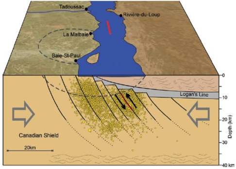
The Figure 4.33 shows that hypocentres (yellow circles)are associated with crater faults rather than with rifting.
سؤال
سؤال
سؤال
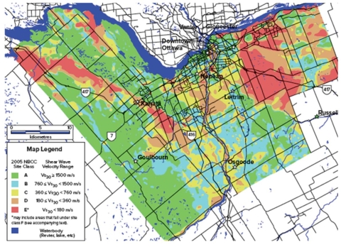
In a seismic zonation map of Ottawa (Fig.4.9)the zones with high shear wave velocity (>1500 m/s)are especially problematic.

فتح الحزمة
قم بالتسجيل لفتح البطاقات في هذه المجموعة!
Unlock Deck
Unlock Deck
1/44
العب
ملء الشاشة (f)
Deck 4: When the Earth Shakes in Canada
1
Earthquake research in Canada focuses primarily on ______________.
A) when a major earthquake will strike
B) where earthquakes are likely to happen
C) how strong the associated ground shaking would be
D) All of these are correct.
E) where earthquakes are likely to happen and how strong the associated ground shaking would be
A) when a major earthquake will strike
B) where earthquakes are likely to happen
C) how strong the associated ground shaking would be
D) All of these are correct.
E) where earthquakes are likely to happen and how strong the associated ground shaking would be
E
2
There have been no observed megathrust earthquakes on the Cascadia Subduction Zone since the year 1700 because _________________.
A) subduction has ceased
B) the plates slip aseismically past each other
C) the fault is currently locked
D) our seismographs aren't sensitive enough
A) subduction has ceased
B) the plates slip aseismically past each other
C) the fault is currently locked
D) our seismographs aren't sensitive enough
C
3
The most active earthquake area in the St.Lawrence River valley is a zone near Charlevoix Quebec because ______________.
A) Canada and United States are converging along the valley
B) Newfoundland is diverging from mainland Canada
C) the crust was weaken by a meteorite impact 350 million years ago
D) it was the site of an igneous intrusion from an ancient volcano
A) Canada and United States are converging along the valley
B) Newfoundland is diverging from mainland Canada
C) the crust was weaken by a meteorite impact 350 million years ago
D) it was the site of an igneous intrusion from an ancient volcano
C
4
Earthquakes occur in the St.Lawrence River valley because ______________.
A) Newfoundland is converging with mainland Canada
B) Newfoundland is diverging from mainland Canada
C) river water destabilizes subsurface rocks
D) the valley follows a buried,failed rift
A) Newfoundland is converging with mainland Canada
B) Newfoundland is diverging from mainland Canada
C) river water destabilizes subsurface rocks
D) the valley follows a buried,failed rift
فتح الحزمة
افتح القفل للوصول البطاقات البالغ عددها 44 في هذه المجموعة.
فتح الحزمة
k this deck
5
The time and date of the last megathrust earthquake on the Cascadia Subduction Zone has been deduced from _______________.
A) dating of coastal trees killed by seawater after sudden subsidence
B) Japanese tsunami records
C) seismograph recordings
D) all of these are correct
E) dating of coastal trees killed by seawater after sudden subsidence and Japanese tsunami records
A) dating of coastal trees killed by seawater after sudden subsidence
B) Japanese tsunami records
C) seismograph recordings
D) all of these are correct
E) dating of coastal trees killed by seawater after sudden subsidence and Japanese tsunami records
فتح الحزمة
افتح القفل للوصول البطاقات البالغ عددها 44 في هذه المجموعة.
فتح الحزمة
k this deck
6
The city with the second highest seismic risk in Canada is _________.
A) Victoria
B) Vancouver
C) Toronto
D) Montreal
A) Victoria
B) Vancouver
C) Toronto
D) Montreal
فتح الحزمة
افتح القفل للوصول البطاقات البالغ عددها 44 في هذه المجموعة.
فتح الحزمة
k this deck
7
Earthquake shake maps are compiled from ________________________.
A) Mercalli intensities compiled from eye-witness accounts.
B) estimates seismic risk
C) intensities calculated from seismic recordings
D) all of these
A) Mercalli intensities compiled from eye-witness accounts.
B) estimates seismic risk
C) intensities calculated from seismic recordings
D) all of these
فتح الحزمة
افتح القفل للوصول البطاقات البالغ عددها 44 في هذه المجموعة.
فتح الحزمة
k this deck
8
Seismic risk in Canada is assessed using the product of which of the following factors?
A) Probability of an earthquake and population
B) Vulnerability of the population and earthquake return period
C) Vulnerability and seismic hazard
D) Probability of an earthquake and seismic hazard
A) Probability of an earthquake and population
B) Vulnerability of the population and earthquake return period
C) Vulnerability and seismic hazard
D) Probability of an earthquake and seismic hazard
فتح الحزمة
افتح القفل للوصول البطاقات البالغ عددها 44 في هذه المجموعة.
فتح الحزمة
k this deck
9
Processes that weaken the crust locally in eastern Canada leading to seismicity include ___________.
A) rifting
B) impact cratering
C) igneous intrusion
D) all of these
A) rifting
B) impact cratering
C) igneous intrusion
D) all of these
فتح الحزمة
افتح القفل للوصول البطاقات البالغ عددها 44 في هذه المجموعة.
فتح الحزمة
k this deck
10
In the National Building Code of Canada,site classification for earthquake hazard is based on ___________.
A) seismic wave shear velocity of the top 30 metres of soil
B) P-wave velocity of the top 30 metres of soil
C) P-wave velocity of the top 100 metres of soil
D) soil depth to bedrock
A) seismic wave shear velocity of the top 30 metres of soil
B) P-wave velocity of the top 30 metres of soil
C) P-wave velocity of the top 100 metres of soil
D) soil depth to bedrock
فتح الحزمة
افتح القفل للوصول البطاقات البالغ عددها 44 في هذه المجموعة.
فتح الحزمة
k this deck
11
Evidence of the last major earthquake in the Cascadia subduction zone include ____________________.
A) disturbed sediments on the seafloor
B) sand layers washed far inshore by tsunami waves
C) repeating sequences of layers of soil in coastal marshes
D) all of these are correct.
E) only sand layers washed far inshore by tsunami waves and repeating sequences of layers of soil in coastal marshes
A) disturbed sediments on the seafloor
B) sand layers washed far inshore by tsunami waves
C) repeating sequences of layers of soil in coastal marshes
D) all of these are correct.
E) only sand layers washed far inshore by tsunami waves and repeating sequences of layers of soil in coastal marshes
فتح الحزمة
افتح القفل للوصول البطاقات البالغ عددها 44 في هذه المجموعة.
فتح الحزمة
k this deck
12
Other than megathrust earthquakes on the Cascadia Subduction Zone,the largest known earthquakes in Canada have occurred on the _________________.
A) St.Lawrence River rift
B) Queen Charlotte fault
C) Newfoundland fracture zone
D) Juan de Fuca fault
A) St.Lawrence River rift
B) Queen Charlotte fault
C) Newfoundland fracture zone
D) Juan de Fuca fault
فتح الحزمة
افتح القفل للوصول البطاقات البالغ عددها 44 في هذه المجموعة.
فتح الحزمة
k this deck
13
The city with the highest seismic risk in Canada is __________.
A) Victoria
B) Vancouver
C) Toronto
D) Montreal
A) Victoria
B) Vancouver
C) Toronto
D) Montreal
فتح الحزمة
افتح القفل للوصول البطاقات البالغ عددها 44 في هذه المجموعة.
فتح الحزمة
k this deck
14
The majority of the ten largest earthquakes in Canada since 1627 occurred in which of the following locations?
A) Cascadia subduction zone,British Columbia.
B) Queen Charlotte Islands,British Columbia.
C) Charlevoix,Quebec.
D) Baffin Island,Northwest Territories.
A) Cascadia subduction zone,British Columbia.
B) Queen Charlotte Islands,British Columbia.
C) Charlevoix,Quebec.
D) Baffin Island,Northwest Territories.
فتح الحزمة
افتح القفل للوصول البطاقات البالغ عددها 44 في هذه المجموعة.
فتح الحزمة
k this deck
15
The probability of a large Cascadia megathrust earthquake in the next 50 years is ___________.
A) 1%
B) 10%
C) 20%
D) 50%
E) 100%
A) 1%
B) 10%
C) 20%
D) 50%
E) 100%
فتح الحزمة
افتح القفل للوصول البطاقات البالغ عددها 44 في هذه المجموعة.
فتح الحزمة
k this deck
16
Based on geologic evidence,the average return period for large Cascadia megathrust earthquakes is in the order of ___________.
A) 20 years
B) 100 years
C) 600 years
D) 1,000 years
A) 20 years
B) 100 years
C) 600 years
D) 1,000 years
فتح الحزمة
افتح القفل للوصول البطاقات البالغ عددها 44 في هذه المجموعة.
فتح الحزمة
k this deck
17
In the time between megathrust earthquakes on the Cascadia Subduction Zone,the over-riding continental North American plate undergoes ______________.
A) uplift and extension
B) subsidence and extension
C) uplift and shortening
D) subsidence and shortening
A) uplift and extension
B) subsidence and extension
C) uplift and shortening
D) subsidence and shortening
فتح الحزمة
افتح القفل للوصول البطاقات البالغ عددها 44 في هذه المجموعة.
فتح الحزمة
k this deck
18
In the past 20 years or so,the number of earthquakes located in Canada each year has increased tremendously due to _________.
A) the global increase in seismic activity of which we are a part
B) isostatic rebound and the continuing post-glacial adjustment of our land mass
C) the Continental response to climate change
D) the increase of seismograph stations which has allowed better earthquake detection
A) the global increase in seismic activity of which we are a part
B) isostatic rebound and the continuing post-glacial adjustment of our land mass
C) the Continental response to climate change
D) the increase of seismograph stations which has allowed better earthquake detection
فتح الحزمة
افتح القفل للوصول البطاقات البالغ عددها 44 في هذه المجموعة.
فتح الحزمة
k this deck
19
Western Quebec has been the site of at least four significant interplate earthquakes.Which of the following hypotheses explain why?
A) A geologically new rift is opening along the Ottawa River Valley.
B) Subsurface fracturing due to a 350 million old meteor impact event.
C) Subsurface fracturing due to igneous intrusion as the North American plate moves over a hot spot.
D) They are triggered by the weight of water held in multiple hydroelectric dams in the area.
فتح الحزمة
افتح القفل للوصول البطاقات البالغ عددها 44 في هذه المجموعة.
فتح الحزمة
k this deck
20
The 1663 Charlevoix earthquake was felt all over Eastern North America,which of the following statements regarding this event is false?
A) It triggered a tsunami
B) It triggered landslides
C) It triggered soil liquefaction
D) No one was killed
A) It triggered a tsunami
B) It triggered landslides
C) It triggered soil liquefaction
D) No one was killed
فتح الحزمة
افتح القفل للوصول البطاقات البالغ عددها 44 في هذه المجموعة.
فتح الحزمة
k this deck
21
Earthquakes along the Queen Charlotte fault share many similarities with the Cascadia Subduction Zone.
فتح الحزمة
افتح القفل للوصول البطاقات البالغ عددها 44 في هذه المجموعة.
فتح الحزمة
k this deck
22
Steam injection and "fracking" are used for ______ and _______ generate small magnitude earthquakes.
A) crude oil extraction from tar sands;cannot
B) crude oil extraction from tar sands;can
C) gold extraction;can
D) copper and zinc extraction from deep underground;cannot
E) energy production;can
A) crude oil extraction from tar sands;cannot
B) crude oil extraction from tar sands;can
C) gold extraction;can
D) copper and zinc extraction from deep underground;cannot
E) energy production;can
فتح الحزمة
افتح القفل للوصول البطاقات البالغ عددها 44 في هذه المجموعة.
فتح الحزمة
k this deck
23
Haida Gwaii earthquake (2012)was triggered along _______________,and as a consequence ___________,south of Cowagla Bay,Moresby Island.
A) the San Andreas fault;a tsunami started
B) the Juan de Fuca plate;debris slides occurred
C) the Queen Charlotte fault;debris slides occurred
D) the San Andreas fault;debris slides
E) the Cascadia Subduction Zone;a tsunami was initiated
A) the San Andreas fault;a tsunami started
B) the Juan de Fuca plate;debris slides occurred
C) the Queen Charlotte fault;debris slides occurred
D) the San Andreas fault;debris slides
E) the Cascadia Subduction Zone;a tsunami was initiated
فتح الحزمة
افتح القفل للوصول البطاقات البالغ عددها 44 في هذه المجموعة.
فتح الحزمة
k this deck
24
Recent work has shown that the last major earthquake in the Cascadia subduction zone occurred about 9 p.m.on 26 January 1700 and was about magnitude 9.
فتح الحزمة
افتح القفل للوصول البطاقات البالغ عددها 44 في هذه المجموعة.
فتح الحزمة
k this deck
25
Reservoir induced seismicity is caused primarily by the great weight of water stored behind large dams.
فتح الحزمة
افتح القفل للوصول البطاقات البالغ عددها 44 في هذه المجموعة.
فتح الحزمة
k this deck
26
The PGA in seismology refers to:
A) Professional Golf Association
B) Post Ground Acceleration
C) Peak Ground Acceleration
D) Peak Gravity Acceleration
E) Peak Ground Assessment
A) Professional Golf Association
B) Post Ground Acceleration
C) Peak Ground Acceleration
D) Peak Gravity Acceleration
E) Peak Ground Assessment
فتح الحزمة
افتح القفل للوصول البطاقات البالغ عددها 44 في هذه المجموعة.
فتح الحزمة
k this deck
27
Geological evidence indicates that 53 large earthquakes have occurred in the Cascadia Subduction Zone over the last 6,000 years.
فتح الحزمة
افتح القفل للوصول البطاقات البالغ عددها 44 في هذه المجموعة.
فتح الحزمة
k this deck
28
The Kidd Creek copper and zinc mine (Canada,2011)experienced a serious magnitude 3.8 rock burst.
فتح الحزمة
افتح القفل للوصول البطاقات البالغ عددها 44 في هذه المجموعة.
فتح الحزمة
k this deck
29
From John Cassidy's story in the Human Focus box,it can be concluded that schools in British Columbia had a long history of earthquake drills.
فتح الحزمة
افتح القفل للوصول البطاقات البالغ عددها 44 في هذه المجموعة.
فتح الحزمة
k this deck
30
Haida Gwaii earthquake (2012)was felt:
A) just in the Vancouver area.
B) up to Toronto (Ontario).
C) as far as Alberta.
D) as far as British Columbia.
E) just in the local area (50km radius).
A) just in the Vancouver area.
B) up to Toronto (Ontario).
C) as far as Alberta.
D) as far as British Columbia.
E) just in the local area (50km radius).
فتح الحزمة
افتح القفل للوصول البطاقات البالغ عددها 44 في هذه المجموعة.
فتح الحزمة
k this deck
31
Canada had a seismically inactive continental interior flanked by active regions to the north,west and east.
فتح الحزمة
افتح القفل للوصول البطاقات البالغ عددها 44 في هذه المجموعة.
فتح الحزمة
k this deck
32
The increasing number of earthquakes recorded in Canada each year indicates that seismicity is increasing.
فتح الحزمة
افتح القفل للوصول البطاقات البالغ عددها 44 في هذه المجموعة.
فتح الحزمة
k this deck
33
Approximately 3,000 earthquakes per year occur in Canada.
فتح الحزمة
افتح القفل للوصول البطاقات البالغ عددها 44 في هذه المجموعة.
فتح الحزمة
k this deck
34
Vulnerability is a difficult parameter to estimate when assessing seismic risk so the population and infrastructure of a city are used.
فتح الحزمة
افتح القفل للوصول البطاقات البالغ عددها 44 في هذه المجموعة.
فتح الحزمة
k this deck
35
Charlevoix,Quebec,has suffered frequent earthquakes because it is the site of an ancient meteorite impact.
فتح الحزمة
افتح القفل للوصول البطاقات البالغ عددها 44 في هذه المجموعة.
فتح الحزمة
k this deck
36
Natural Resources Canada recognizes and earthquake as significant when the magnitude is equal to or greater than 6 or the modified intensity is VI or stronger.
فتح الحزمة
افتح القفل للوصول البطاقات البالغ عددها 44 في هذه المجموعة.
فتح الحزمة
k this deck
37
All Canadian mines are equipped with seismic monitoring networks except mines for gas production (shale gas extraction).
فتح الحزمة
افتح القفل للوصول البطاقات البالغ عددها 44 في هذه المجموعة.
فتح الحزمة
k this deck
38
Marie de L'Incarnation (1599-1672)wrote a vivid account of the Charlevoix earthquake (1663),describing that:
A) the fault zone dropped 3 metres and the St.Lawrence River became 20 metres wider
B) the St.Lawrence River changed and assumed the colour of sulphur
C) this was a sign that God did not punish humankind,but merely issued a warning
D) it was quite strange that bells of churches didn't peal alone
E) the St.Lawrence River changed and assumed the colour of sulphur and this was a sign that God did not punish humankind,but merely issued a warning
فتح الحزمة
افتح القفل للوصول البطاقات البالغ عددها 44 في هذه المجموعة.
فتح الحزمة
k this deck
39
The National Building Code of Canada is especially concerned:
A) about areas where overlap might occur between the natural frequencies of the seismic waves,local soil conditions,and buildings.
B) about the seismic waves propagation at 1 km below ground surface.
C) about the unreinforced masonry buildings.
D) about the new buildings in Canadian seismic risk zones.
E) about areas where overlap might occur between the natural frequencies of the seismic waves,local soil conditions,and buildings,and about the unreinforced masonry buildings.
فتح الحزمة
افتح القفل للوصول البطاقات البالغ عددها 44 في هذه المجموعة.
فتح الحزمة
k this deck
40
Canada's second largest earthquake occurred in the Queen Charlotte Island (now Haida Gwaii)Subduction Zone.
فتح الحزمة
افتح القفل للوصول البطاقات البالغ عددها 44 في هذه المجموعة.
فتح الحزمة
k this deck
41
The Figure 4.33 shows that hypocentres (yellow circles)are associated with crater faults rather than with rifting.
فتح الحزمة
افتح القفل للوصول البطاقات البالغ عددها 44 في هذه المجموعة.
فتح الحزمة
k this deck
42
The Haida Gwaii earthquake (2012),British Columbia,triggered a tsunami but not mass movements.
فتح الحزمة
افتح القفل للوصول البطاقات البالغ عددها 44 في هذه المجموعة.
فتح الحزمة
k this deck
43
In the National Building Code of Canada more stringent provisions apply to buildings with regular shape.
فتح الحزمة
افتح القفل للوصول البطاقات البالغ عددها 44 في هذه المجموعة.
فتح الحزمة
k this deck
44
In a seismic zonation map of Ottawa (Fig.4.9)the zones with high shear wave velocity (>1500 m/s)are especially problematic.
فتح الحزمة
افتح القفل للوصول البطاقات البالغ عددها 44 في هذه المجموعة.
فتح الحزمة
k this deck
فتح الحزمة
افتح القفل للوصول البطاقات البالغ عددها 44 في هذه المجموعة.


