Deck 25: Ever-Changing Landscapes and the Hydrologic Cycle
ملء الشاشة (f)
سؤال
What is the maximum relief of the land surface in the topographic map below? 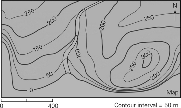
A) 50 m
B) 100 m
C) 300 m
D) 400 m
A) 50 m
B) 100 m
C) 300 m
D) 400 m
سؤال
سؤال
The mountains around Rio de Janeiro shown in the below image represent a landscape with 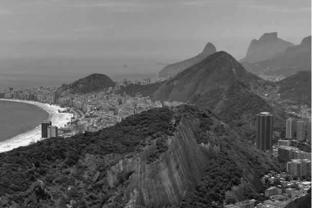
A) subsidence.
B) no erosion.
C) low relief.
D) high relief.
A) subsidence.
B) no erosion.
C) low relief.
D) high relief.
سؤال
سؤال
سؤال
سؤال
سؤال
سؤال
سؤال
سؤال
سؤال
سؤال
سؤال
سؤال
What process created the terrace that forms the cliff in the picture below? 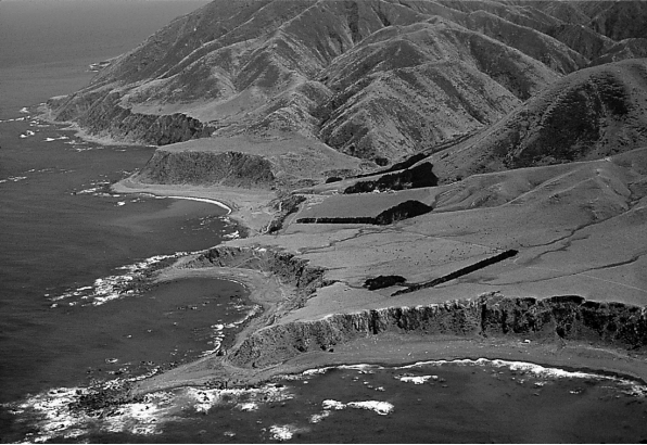
A) subsidence
B) deposition
C) uplift
D) relief
A) subsidence
B) deposition
C) uplift
D) relief
سؤال
سؤال
سؤال
What is the ultimate cause for the development of the landscape,the large road cut,in the following picture? 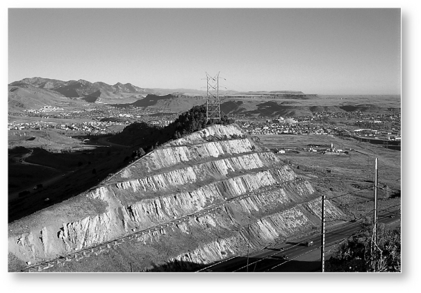
A) climate
B) human activity
C) time
D) relief
A) climate
B) human activity
C) time
D) relief
سؤال
سؤال
سؤال
Below is an oblique view showing landforms on Mars.What process is most likely responsible for creating this landscape? 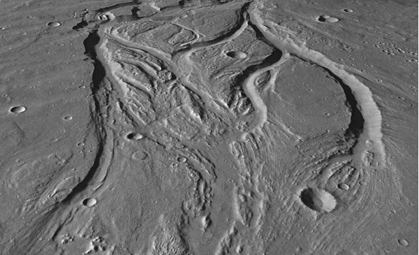
A) glacial carving
B) deposition
C) flowing water
D) burrowing
A) glacial carving
B) deposition
C) flowing water
D) burrowing
سؤال
سؤال
سؤال
سؤال
سؤال
سؤال
سؤال
Study the topographic map below.Label where the map indicates the highest relief.Describe one possible interpretation of why this landscape has an area of high relief and other areas of lower relief. 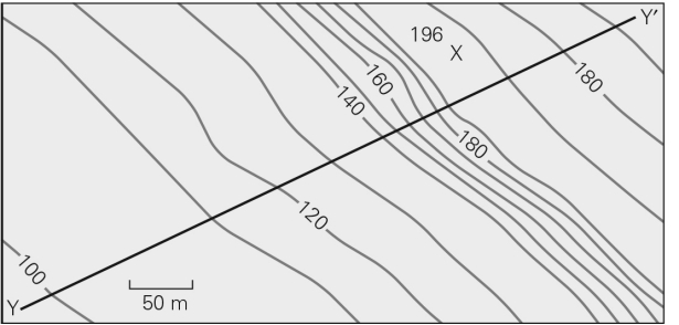
سؤال
سؤال

فتح الحزمة
قم بالتسجيل لفتح البطاقات في هذه المجموعة!
Unlock Deck
Unlock Deck
1/30
العب
ملء الشاشة (f)
Deck 25: Ever-Changing Landscapes and the Hydrologic Cycle
1
What is the maximum relief of the land surface in the topographic map below?
A) 50 m
B) 100 m
C) 300 m
D) 400 m
A) 50 m
B) 100 m
C) 300 m
D) 400 m
C
2
The difference between highest and lowest elevation in an area is called
A) erosion.
B) deposition.
C) relief.
D) landform.
A) erosion.
B) deposition.
C) relief.
D) landform.
C
3
The mountains around Rio de Janeiro shown in the below image represent a landscape with
A) subsidence.
B) no erosion.
C) low relief.
D) high relief.
A) subsidence.
B) no erosion.
C) low relief.
D) high relief.
D
4
How does water get from the atmosphere into the groundwater system?
A) Precipitation falls into rivers and then flows downriver into the groundwater system.
B) Precipitation falls on the ground and infiltrates the ground surface to the groundwater system.
C) Water from the ocean is sucked into the groundwater system due to a pressure difference.
D) Plants secrete water into the groundwater system in a process called evapotranspiration.
فتح الحزمة
افتح القفل للوصول البطاقات البالغ عددها 30 في هذه المجموعة.
فتح الحزمة
k this deck
5
What are landforms?
A) individual shapes that make up a landscape
B) a synonym for continental crust
C) another term for landscape
D) paperwork relating to owning property
A) individual shapes that make up a landscape
B) a synonym for continental crust
C) another term for landscape
D) paperwork relating to owning property
فتح الحزمة
افتح القفل للوصول البطاقات البالغ عددها 30 في هذه المجموعة.
فتح الحزمة
k this deck
6
Why do some life activities strengthen the substrate while others weaken it?
A) Burrowing creatures distribute stronger soil around,while plants digest and weaken soil.
B) Burrowing creatures distribute stronger soil around,while plant roots wedge soil apart.
C) Plant roots help anchor soil,while animals burrowing into or mining out soil weakens it.
D) Some organisms secrete a binding agent in the soil,while plants digest and weaken soil.
فتح الحزمة
افتح القفل للوصول البطاقات البالغ عددها 30 في هذه المجموعة.
فتح الحزمة
k this deck
7
What would an area experiencing erosion look like compared to one experiencing deposition?
A) deep valleys or canyons versus large flat,open areas
B) large sand dunes versus large open bodies of water
C) rolling hills versus steep peaks
D) large,dry flatlands versus deep river channels
A) deep valleys or canyons versus large flat,open areas
B) large sand dunes versus large open bodies of water
C) rolling hills versus steep peaks
D) large,dry flatlands versus deep river channels
فتح الحزمة
افتح القفل للوصول البطاقات البالغ عددها 30 في هذه المجموعة.
فتح الحزمة
k this deck
8
Which of the following does NOT affect landscape development?
A) distance from mountains
B) climate in the area
C) amount of time
D) amount of erosion
A) distance from mountains
B) climate in the area
C) amount of time
D) amount of erosion
فتح الحزمة
افتح القفل للوصول البطاقات البالغ عددها 30 في هذه المجموعة.
فتح الحزمة
k this deck
9
Climate affects landscape development by controlling
A) the composition of the substrate.
B) whether the rocks show signs of brittle deformation.
C) the space available to deposit sediments.
D) whether ice,wind,or water will be the main agents of erosion.
A) the composition of the substrate.
B) whether the rocks show signs of brittle deformation.
C) the space available to deposit sediments.
D) whether ice,wind,or water will be the main agents of erosion.
فتح الحزمة
افتح القفل للوصول البطاقات البالغ عددها 30 في هذه المجموعة.
فتح الحزمة
k this deck
10
Which of the following is responsible for most landscale development on the Earth over geologic time?
A) moving water
B) animals and plants
C) glacial ice
D) winds
A) moving water
B) animals and plants
C) glacial ice
D) winds
فتح الحزمة
افتح القفل للوصول البطاقات البالغ عددها 30 في هذه المجموعة.
فتح الحزمة
k this deck
11
Which of the following best describes the hydrologic cycle?
A) the movement of water through the ground to form aquifers
B) the cycle that water passes through when going from solid to liquid to gas
C) the circular motion due to density differences created when water boils
D) the transfer of the Earth's water through a series of natural reservoirs
A) the movement of water through the ground to form aquifers
B) the cycle that water passes through when going from solid to liquid to gas
C) the circular motion due to density differences created when water boils
D) the transfer of the Earth's water through a series of natural reservoirs
فتح الحزمة
افتح القفل للوصول البطاقات البالغ عددها 30 في هذه المجموعة.
فتح الحزمة
k this deck
12
The term for the character and shape of the Earth's surface in a region is ________.
A) landform
B) erosional surface
C) landscape
D) watershed
A) landform
B) erosional surface
C) landscape
D) watershed
فتح الحزمة
افتح القفل للوصول البطاقات البالغ عددها 30 في هذه المجموعة.
فتح الحزمة
k this deck
13
Which of the following is a direct result of the Earth's internal energy?
A) uplift
B) deposition
C) erosion
D) gravity
A) uplift
B) deposition
C) erosion
D) gravity
فتح الحزمة
افتح القفل للوصول البطاقات البالغ عددها 30 في هذه المجموعة.
فتح الحزمة
k this deck
14
Which progression best describes how water from the ocean gets into a river?
A) evaporation -> precipitation -> infiltration into the ground
B) evaporation -> precipitation -> runoff
C) evaporation -> precipitation -> evapotranspiration
D) evapotranspiration -> runoff -> precipitation
A) evaporation -> precipitation -> infiltration into the ground
B) evaporation -> precipitation -> runoff
C) evaporation -> precipitation -> evapotranspiration
D) evapotranspiration -> runoff -> precipitation
فتح الحزمة
افتح القفل للوصول البطاقات البالغ عددها 30 في هذه المجموعة.
فتح الحزمة
k this deck
15
What process created the terrace that forms the cliff in the picture below?
A) subsidence
B) deposition
C) uplift
D) relief
A) subsidence
B) deposition
C) uplift
D) relief
فتح الحزمة
افتح القفل للوصول البطاقات البالغ عددها 30 في هذه المجموعة.
فتح الحزمة
k this deck
16
What circumstance is likely to produce depositional landforms?
A) flash flooding of a river in the desert
B) a river flowing out of a lake
C) a river entering a large body of water
D) ocean waves crashing on the beach
A) flash flooding of a river in the desert
B) a river flowing out of a lake
C) a river entering a large body of water
D) ocean waves crashing on the beach
فتح الحزمة
افتح القفل للوصول البطاقات البالغ عددها 30 في هذه المجموعة.
فتح الحزمة
k this deck
17
If erosion is occurring in an area of weak rock,what would you expect the landscape to look like?
A) gentle hills
B) steep cliffs
C) uplifted terraces
D) vertical canyons
A) gentle hills
B) steep cliffs
C) uplifted terraces
D) vertical canyons
فتح الحزمة
افتح القفل للوصول البطاقات البالغ عددها 30 في هذه المجموعة.
فتح الحزمة
k this deck
18
What is the ultimate cause for the development of the landscape,the large road cut,in the following picture?
A) climate
B) human activity
C) time
D) relief
A) climate
B) human activity
C) time
D) relief
فتح الحزمة
افتح القفل للوصول البطاقات البالغ عددها 30 في هذه المجموعة.
فتح الحزمة
k this deck
19
If an area experiences uplift,it will form a ________; if it experiences subsidence,it will form a ________.
A) depression; mountain
B) mountain; depression
C) valley; mesa
D) basin; mountain
A) depression; mountain
B) mountain; depression
C) valley; mesa
D) basin; mountain
فتح الحزمة
افتح القفل للوصول البطاقات البالغ عددها 30 في هذه المجموعة.
فتح الحزمة
k this deck
20
Landforms built by an accumulation of sediment are called ________ landforms.
A) erosional
B) depositional
C) mechanical
D) glacial
A) erosional
B) depositional
C) mechanical
D) glacial
فتح الحزمة
افتح القفل للوصول البطاقات البالغ عددها 30 في هذه المجموعة.
فتح الحزمة
k this deck
21
Below is an oblique view showing landforms on Mars.What process is most likely responsible for creating this landscape?
A) glacial carving
B) deposition
C) flowing water
D) burrowing
A) glacial carving
B) deposition
C) flowing water
D) burrowing
فتح الحزمة
افتح القفل للوصول البطاقات البالغ عددها 30 في هذه المجموعة.
فتح الحزمة
k this deck
22
Which reservoir in the hydrologic cycle contains most of the Earth's mass of liquid fresh water?
A) the oceans
B) groundwater
C) rivers and lakes
D) the atmosphere
A) the oceans
B) groundwater
C) rivers and lakes
D) the atmosphere
فتح الحزمة
افتح القفل للوصول البطاقات البالغ عددها 30 في هذه المجموعة.
فتح الحزمة
k this deck
23
Starting with a drop of water in the ocean,describe a full cycle of movement of the water drop through the hydrologic cycle (the water must end up back in the ocean).Through what reservoirs does that water move? What physical forms does the water take (e.g.,liquid,solid,gas)?
فتح الحزمة
افتح القفل للوصول البطاقات البالغ عددها 30 في هذه المجموعة.
فتح الحزمة
k this deck
24
Water can remain in the ground as groundwater for up many thousands of years.This is called
A) aquifer storage.
B) the groundwater flow rate.
C) residence time.
D) transfer time.
A) aquifer storage.
B) the groundwater flow rate.
C) residence time.
D) transfer time.
فتح الحزمة
افتح القفل للوصول البطاقات البالغ عددها 30 في هذه المجموعة.
فتح الحزمة
k this deck
25
What is a landform and how is it linked to the landscape?
فتح الحزمة
افتح القفل للوصول البطاقات البالغ عددها 30 في هذه المجموعة.
فتح الحزمة
k this deck
26
Why is understanding the hydrologic cycle important to understanding how landscapes form?
A) because water has the ability to seep underground and affect the layers of rock
B) because the oceans cover a vast majority of our planet and are a main erosional agent
C) because the rate at which groundwater moves through the subsurface determines erosion rates
D) because water is the main agent of erosion and deposition on the Earth
فتح الحزمة
افتح القفل للوصول البطاقات البالغ عددها 30 في هذه المجموعة.
فتح الحزمة
k this deck
27
Why are the landscapes on Mars so different from those on the Earth?
A) The life forms on Mars do not cause landforms.
B) Mars does not have plate tectonics.
C) Wind is not an agent of erosion on Mars.
D) Water and ice have never been agents of erosion on Mars.
A) The life forms on Mars do not cause landforms.
B) Mars does not have plate tectonics.
C) Wind is not an agent of erosion on Mars.
D) Water and ice have never been agents of erosion on Mars.
فتح الحزمة
افتح القفل للوصول البطاقات البالغ عددها 30 في هذه المجموعة.
فتح الحزمة
k this deck
28
Study the topographic map below.Label where the map indicates the highest relief.Describe one possible interpretation of why this landscape has an area of high relief and other areas of lower relief.
فتح الحزمة
افتح القفل للوصول البطاقات البالغ عددها 30 في هذه المجموعة.
فتح الحزمة
k this deck
29
Provide three examples of agents of erosion.Would the landforms created by each of these agents be similar or different? Explain.
فتح الحزمة
افتح القفل للوصول البطاقات البالغ عددها 30 في هذه المجموعة.
فتح الحزمة
k this deck
30
Contrast the types of energy that control uplift and erosion.
فتح الحزمة
افتح القفل للوصول البطاقات البالغ عددها 30 في هذه المجموعة.
فتح الحزمة
k this deck
فتح الحزمة
افتح القفل للوصول البطاقات البالغ عددها 30 في هذه المجموعة.


