Deck 14: Streams and Floods: the Geology of Running Water
ملء الشاشة (f)
سؤال
سؤال
سؤال
سؤال
سؤال
سؤال
A trellis drainage network such as the one shown below is most like to form in landscapes develop on which type of geologic structure(s)or feature(s)? 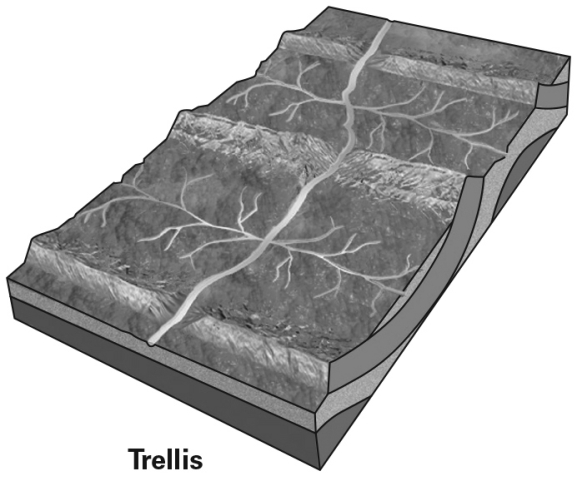
A) volcanoes
B) heavily fractured bedrock
C) thick,uniform regolith
D) anticlines and synclines
A) volcanoes
B) heavily fractured bedrock
C) thick,uniform regolith
D) anticlines and synclines
سؤال
سؤال
سؤال
The largest drainage basin in the United States drains into the: 
A) Pacific Ocean
B) Arctic Ocean
C) Gulf of Mexico
D) Atlantic Ocean
A) Pacific Ocean
B) Arctic Ocean
C) Gulf of Mexico
D) Atlantic Ocean
سؤال
سؤال
سؤال
سؤال
سؤال
What kind of drainage network is likely to form in a landscape characterized by a parallel series of ridges and valleys? 
A) dendritic
B) radial
C) rectangular
D) trellis
A) dendritic
B) radial
C) rectangular
D) trellis
سؤال
سؤال
سؤال
سؤال
A parallel drainage network such as the one shown below develops on a very steep slope.What type of geologic processes can be inferred from the presence of a parallel drainage network? 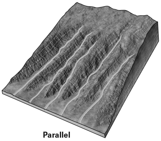
A) recent retreat of a glacier
B) a dried-out lake bed
C) recent uplift,such as along a fault
D) seasonal flooding
A) recent retreat of a glacier
B) a dried-out lake bed
C) recent uplift,such as along a fault
D) seasonal flooding
سؤال
What kind of drainage network is likely to form in a landscape where the bedrock is broken by a regularly-spaced grid of joints and fractures? 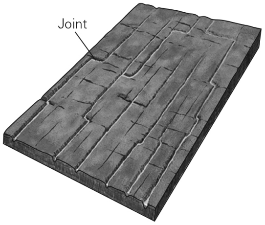
A) dendritic
B) radial
C) rectangular
D) trellis
A) dendritic
B) radial
C) rectangular
D) trellis
سؤال
سؤال
سؤال
سؤال
سؤال
سؤال
سؤال
سؤال
سؤال
سؤال
سؤال
سؤال
Meandering streams ________. 
A) consist of a series of intertwined channels that are overloaded with sediment
B) have flowing water either episodically or during only a portion of the year
C) have a channel that is highly sinuous (curvy)
D) are those that divert flow from streams they have intersected through stream erosion
A) consist of a series of intertwined channels that are overloaded with sediment
B) have flowing water either episodically or during only a portion of the year
C) have a channel that is highly sinuous (curvy)
D) are those that divert flow from streams they have intersected through stream erosion
سؤال
سؤال
سؤال
سؤال
سؤال
سؤال
سؤال
سؤال
سؤال
In the picture below,fragments of bed load bounce along the bed and knock other grains up into the flow to move downstream for short distances.This process is called 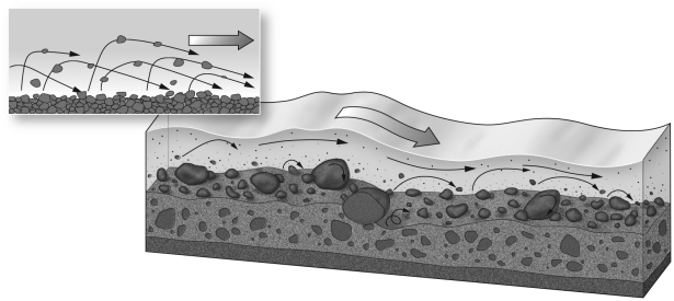
A) saltation.
B) meandering.
C) stream piracy.
D) base level.
A) saltation.
B) meandering.
C) stream piracy.
D) base level.
سؤال
سؤال
سؤال
سؤال
سؤال
سؤال
سؤال
Using the image below,label the stream channel,meander,floodplain,headwaters,and mouth.Additionally,sketch a cross-section of this stream from A to A' and from C to C'. 
سؤال
سؤال
سؤال
سؤال
سؤال
سؤال
سؤال
سؤال
سؤال
سؤال
سؤال
سؤال
سؤال

فتح الحزمة
قم بالتسجيل لفتح البطاقات في هذه المجموعة!
Unlock Deck
Unlock Deck
1/60
العب
ملء الشاشة (f)
Deck 14: Streams and Floods: the Geology of Running Water
1
What kind of drainage network is likely to form in a landscape with a uniform substrate and a constant and gentle slope at the surface?
A) dendritic
B) radial
C) rectangular
D) trellis
A) dendritic
B) radial
C) rectangular
D) trellis
A
2
A stream carrying sediment flows over the solid rock of its channel,polishing the rock and wearing it away.This is an example of __________.
A) scouring
B) abrasion
C) dissolution
D) saltation
A) scouring
B) abrasion
C) dissolution
D) saltation
B
3
Running water dissolves soluble minerals.This material is most likely to be transported by a stream as _________.
A) suspended load
B) dissolved load
C) bed load
D) discharge
A) suspended load
B) dissolved load
C) bed load
D) discharge
B
4
Which river has the greatest discharge of any stream on the Earth?
A) Nile
B) Mississippi
C) Congo
D) Amazon
A) Nile
B) Mississippi
C) Congo
D) Amazon
فتح الحزمة
افتح القفل للوصول البطاقات البالغ عددها 60 في هذه المجموعة.
فتح الحزمة
k this deck
5
Which landscape feature is most likely to form a drainage divide?
A) an mountain ridge
B) a lake
C) a canyon
D) a delta
A) an mountain ridge
B) a lake
C) a canyon
D) a delta
فتح الحزمة
افتح القفل للوصول البطاقات البالغ عددها 60 في هذه المجموعة.
فتح الحزمة
k this deck
6
A trellis drainage network such as the one shown below is most like to form in landscapes develop on which type of geologic structure(s)or feature(s)?
A) volcanoes
B) heavily fractured bedrock
C) thick,uniform regolith
D) anticlines and synclines
A) volcanoes
B) heavily fractured bedrock
C) thick,uniform regolith
D) anticlines and synclines
فتح الحزمة
افتح القفل للوصول البطاقات البالغ عددها 60 في هذه المجموعة.
فتح الحزمة
k this deck
7
Over time,a stream tends to increase in length by eroding and extending its channel upstream,in a process called ________.
A) downstream piracy
B) headward erosion
C) downcutting
D) infiltration
A) downstream piracy
B) headward erosion
C) downcutting
D) infiltration
فتح الحزمة
افتح القفل للوصول البطاقات البالغ عددها 60 في هذه المجموعة.
فتح الحزمة
k this deck
8
Water in a stream flows from its _________ to its __________.
A) mouth,headwaters
B) mouth,source
C) source,headwaters
D) headwaters,mouth
A) mouth,headwaters
B) mouth,source
C) source,headwaters
D) headwaters,mouth
فتح الحزمة
افتح القفل للوصول البطاقات البالغ عددها 60 في هذه المجموعة.
فتح الحزمة
k this deck
9
The largest drainage basin in the United States drains into the:
A) Pacific Ocean
B) Arctic Ocean
C) Gulf of Mexico
D) Atlantic Ocean
A) Pacific Ocean
B) Arctic Ocean
C) Gulf of Mexico
D) Atlantic Ocean
فتح الحزمة
افتح القفل للوصول البطاقات البالغ عددها 60 في هذه المجموعة.
فتح الحزمة
k this deck
10
A stream is ________.
A) flowing water confined to a channel
B) a small river found near its headwaters
C) a small river near the mouth
D) a large river near its source
A) flowing water confined to a channel
B) a small river found near its headwaters
C) a small river near the mouth
D) a large river near its source
فتح الحزمة
افتح القفل للوصول البطاقات البالغ عددها 60 في هذه المجموعة.
فتح الحزمة
k this deck
11
What is the term for the land area drained by all of the streams that empty into a tributary?
A) a drainage divide
B) a watershed
C) a drainage network
D) a meander
A) a drainage divide
B) a watershed
C) a drainage network
D) a meander
فتح الحزمة
افتح القفل للوصول البطاقات البالغ عددها 60 في هذه المجموعة.
فتح الحزمة
k this deck
12
The main stream that is supplied by all tributaries within a drainage network is termed a ________ stream.
A) lead
B) trunk
C) taproot
D) pirate
A) lead
B) trunk
C) taproot
D) pirate
فتح الحزمة
افتح القفل للوصول البطاقات البالغ عددها 60 في هذه المجموعة.
فتح الحزمة
k this deck
13
In an ephemeral stream,the groundwater table lies _________ the streambed.
A) on the right side of
B) upstream from
C) above
D) below
A) on the right side of
B) upstream from
C) above
D) below
فتح الحزمة
افتح القفل للوصول البطاقات البالغ عددها 60 في هذه المجموعة.
فتح الحزمة
k this deck
14
What kind of drainage network is likely to form in a landscape characterized by a parallel series of ridges and valleys?
A) dendritic
B) radial
C) rectangular
D) trellis
A) dendritic
B) radial
C) rectangular
D) trellis
فتح الحزمة
افتح القفل للوصول البطاقات البالغ عددها 60 في هذه المجموعة.
فتح الحزمة
k this deck
15
What is runoff?
A) water that infiltrates into groundwater
B) water contained in lakes and reservoirs
C) flowing freshwater water on the Earth's surface
D) water flowing over waterfalls
A) water that infiltrates into groundwater
B) water contained in lakes and reservoirs
C) flowing freshwater water on the Earth's surface
D) water flowing over waterfalls
فتح الحزمة
افتح القفل للوصول البطاقات البالغ عددها 60 في هذه المجموعة.
فتح الحزمة
k this deck
16
Ephemeral streams ________.
A) consist of a series of intertwined channels that are overloaded with sediment
B) have flowing water either episodically or during only a portion of the year
C) have a channel that is highly sinuous (curvy)
D) are those that divert flow from streams they have intersected through stream erosion
A) consist of a series of intertwined channels that are overloaded with sediment
B) have flowing water either episodically or during only a portion of the year
C) have a channel that is highly sinuous (curvy)
D) are those that divert flow from streams they have intersected through stream erosion
فتح الحزمة
افتح القفل للوصول البطاقات البالغ عددها 60 في هذه المجموعة.
فتح الحزمة
k this deck
17
What kind of drainage network is likely to form in a landscape characterized by a uniform and steep slope and a relatively weak substrate?
A) dendritic
B) parallel
C) rectangular
D) trellis
A) dendritic
B) parallel
C) rectangular
D) trellis
فتح الحزمة
افتح القفل للوصول البطاقات البالغ عددها 60 في هذه المجموعة.
فتح الحزمة
k this deck
18
A parallel drainage network such as the one shown below develops on a very steep slope.What type of geologic processes can be inferred from the presence of a parallel drainage network?
A) recent retreat of a glacier
B) a dried-out lake bed
C) recent uplift,such as along a fault
D) seasonal flooding
A) recent retreat of a glacier
B) a dried-out lake bed
C) recent uplift,such as along a fault
D) seasonal flooding
فتح الحزمة
افتح القفل للوصول البطاقات البالغ عددها 60 في هذه المجموعة.
فتح الحزمة
k this deck
19
What kind of drainage network is likely to form in a landscape where the bedrock is broken by a regularly-spaced grid of joints and fractures?
A) dendritic
B) radial
C) rectangular
D) trellis
A) dendritic
B) radial
C) rectangular
D) trellis
فتح الحزمة
افتح القفل للوصول البطاقات البالغ عددها 60 في هذه المجموعة.
فتح الحزمة
k this deck
20
A radial drainage network is likely to indicate a current or former _______ in the landscape.
A) landslide
B) volcano
C) mountain belt
D) glacier
A) landslide
B) volcano
C) mountain belt
D) glacier
فتح الحزمة
افتح القفل للوصول البطاقات البالغ عددها 60 في هذه المجموعة.
فتح الحزمة
k this deck
21
The deepest part of a curved stream channel,where the flow is fastest,is called the ________.
A) base level
B) point bar
C) stream gradient
D) thalweg
A) base level
B) point bar
C) stream gradient
D) thalweg
فتح الحزمة
افتح القفل للوصول البطاقات البالغ عددها 60 في هذه المجموعة.
فتح الحزمة
k this deck
22
A "bird's foot" delta such as the Mississippi River delta forms when the ________.
A) oceanic current exceeds the river current
B) oceanic current is so strong that all sediment is removed as it arrives
C) river and oceanic currents are equal
D) river current exceeds the oceanic current
A) oceanic current exceeds the river current
B) oceanic current is so strong that all sediment is removed as it arrives
C) river and oceanic currents are equal
D) river current exceeds the oceanic current
فتح الحزمة
افتح القفل للوصول البطاقات البالغ عددها 60 في هذه المجموعة.
فتح الحزمة
k this deck
23
The distinction between a valley and a canyon is ________.
A) nonexistent; the two terms are synonymous
B) that the sides of a canyon are more steep than those of a valley
C) that the sides of a valley are more steep than those of a canyon
D) that valleys are often cut by streams,whereas canyons are eroded by the wind
A) nonexistent; the two terms are synonymous
B) that the sides of a canyon are more steep than those of a valley
C) that the sides of a valley are more steep than those of a canyon
D) that valleys are often cut by streams,whereas canyons are eroded by the wind
فتح الحزمة
افتح القفل للوصول البطاقات البالغ عددها 60 في هذه المجموعة.
فتح الحزمة
k this deck
24
The average velocity of water in a stream
A) is the velocity of the water at the surface of the stream.
B) is the velocity on in the inside of curves in the stream's path.
C) is the velocity at which all of the water is moving.
D) is an approximation to account for friction and turbulence.
A) is the velocity of the water at the surface of the stream.
B) is the velocity on in the inside of curves in the stream's path.
C) is the velocity at which all of the water is moving.
D) is an approximation to account for friction and turbulence.
فتح الحزمة
افتح القفل للوصول البطاقات البالغ عددها 60 في هذه المجموعة.
فتح الحزمة
k this deck
25
What physical property of the underlying rock would lead to the formation of a cliff over which a waterfall may form?
A) a high resistance to erosion
B) high porosity
C) large permeability
D) very fine grain sizes
A) a high resistance to erosion
B) high porosity
C) large permeability
D) very fine grain sizes
فتح الحزمة
افتح القفل للوصول البطاقات البالغ عددها 60 في هذه المجموعة.
فتح الحزمة
k this deck
26
Repeated flooding outside a stream channel and across an entire floodplain can result in a pair of low ridges on either side of a stream termed
A) cut banks.
B) natural levees.
C) pirated streams.
D) oxbow lakes.
A) cut banks.
B) natural levees.
C) pirated streams.
D) oxbow lakes.
فتح الحزمة
افتح القفل للوصول البطاقات البالغ عددها 60 في هذه المجموعة.
فتح الحزمة
k this deck
27
If over time a stream experiences a decrease in its base level or increase in discharge,a(n)________ is likely to form.
A) alluvial terrace
B) slot canyon
C) meander
D) waterfall
A) alluvial terrace
B) slot canyon
C) meander
D) waterfall
فتح الحزمة
افتح القفل للوصول البطاقات البالغ عددها 60 في هذه المجموعة.
فتح الحزمة
k this deck
28
The base level of a tributary would ________ if a dam and a reservoir were constructed where it flowed into a trunk stream.
A) be unchanged
B) become unpredictable
C) fall
D) rise
A) be unchanged
B) become unpredictable
C) fall
D) rise
فتح الحزمة
افتح القفل للوصول البطاقات البالغ عددها 60 في هذه المجموعة.
فتح الحزمة
k this deck
29
In some cases,the push of flowing water cause large particles to bounce or roll along a streambed.These pieces are then carried along the bottom of the stream as _________.
A) suspended load
B) dissolved load
C) bed load
D) discharge
A) suspended load
B) dissolved load
C) bed load
D) discharge
فتح الحزمة
افتح القفل للوصول البطاقات البالغ عددها 60 في هذه المجموعة.
فتح الحزمة
k this deck
30
A geologist finds an old report on stream discharge and reads a value of "20",but the rest of the page is cut off.Which of the following could be the appropriate value and units for the discharge of a stream?
A) 20 meters per second
B) 20 cubic meters per second
C) 20 square meters per second
D) 20 seconds per cubic meter
A) 20 meters per second
B) 20 cubic meters per second
C) 20 square meters per second
D) 20 seconds per cubic meter
فتح الحزمة
افتح القفل للوصول البطاقات البالغ عددها 60 في هذه المجموعة.
فتح الحزمة
k this deck
31
Meandering streams ________.
A) consist of a series of intertwined channels that are overloaded with sediment
B) have flowing water either episodically or during only a portion of the year
C) have a channel that is highly sinuous (curvy)
D) are those that divert flow from streams they have intersected through stream erosion
A) consist of a series of intertwined channels that are overloaded with sediment
B) have flowing water either episodically or during only a portion of the year
C) have a channel that is highly sinuous (curvy)
D) are those that divert flow from streams they have intersected through stream erosion
فتح الحزمة
افتح القفل للوصول البطاقات البالغ عددها 60 في هذه المجموعة.
فتح الحزمة
k this deck
32
Which of the following is most likely to make up the suspended load of a stream?
A) ions that formed when minerals dissolved in groundwater
B) large boulders that fell into the stream during a landslide
C) gravel that washed into the stream during a flood
D) small grains of clay and silt
A) ions that formed when minerals dissolved in groundwater
B) large boulders that fell into the stream during a landslide
C) gravel that washed into the stream during a flood
D) small grains of clay and silt
فتح الحزمة
افتح القفل للوصول البطاقات البالغ عددها 60 في هذه المجموعة.
فتح الحزمة
k this deck
33
The discharge of a river traveling through a temperate region will typically ________ downstream; the discharge of a river traveling through an arid region will typically ________ downstream.
A) increase; increase
B) decrease; decrease
C) increase; decrease
D) decrease; increase
A) increase; increase
B) decrease; decrease
C) increase; decrease
D) decrease; increase
فتح الحزمة
افتح القفل للوصول البطاقات البالغ عددها 60 في هذه المجموعة.
فتح الحزمة
k this deck
34
Why do deltas form?
A) because tidal currents carry sediment from elsewhere along the shoreline
B) because when streams reach base level,the sediment they carry settles out and is deposited
C) because stream sediments cannot be transported in seawater
D) because in places,stream water sinks into the ground where it meets the oceans,leaving behind sediments
فتح الحزمة
افتح القفل للوصول البطاقات البالغ عددها 60 في هذه المجموعة.
فتح الحزمة
k this deck
35
The shape of a delta is primarily determined by ________.
A) the shape of the river channel near the mouth
B) the average grain size of the suspended and bed loads
C) whether river currents or ocean currents are locally predominant
D) the type of rock that is weathering at the outcrop near the headwaters of the river
A) the shape of the river channel near the mouth
B) the average grain size of the suspended and bed loads
C) whether river currents or ocean currents are locally predominant
D) the type of rock that is weathering at the outcrop near the headwaters of the river
فتح الحزمة
افتح القفل للوصول البطاقات البالغ عددها 60 في هذه المجموعة.
فتح الحزمة
k this deck
36
What shape does the longitudinal profile of a typical stream follow? A longitudinal profile plots elevation of a streambed with distance,showing the streambed elevation from its highest point upstream to the lowest point at base level.
A) a straight diagonal line
B) a straight horizontal line
C) concave upward
D) a line with random high and low points
A) a straight diagonal line
B) a straight horizontal line
C) concave upward
D) a line with random high and low points
فتح الحزمة
افتح القفل للوصول البطاقات البالغ عددها 60 في هذه المجموعة.
فتح الحزمة
k this deck
37
Ultimately,the base level of a stream valley cannot be lower than ________.
A) the average elevation of the continent on which it is found
B) sea level
C) the average elevation of the local catchment
D) the maximum elevation of the local catchment
A) the average elevation of the continent on which it is found
B) sea level
C) the average elevation of the local catchment
D) the maximum elevation of the local catchment
فتح الحزمة
افتح القفل للوصول البطاقات البالغ عددها 60 في هذه المجموعة.
فتح الحزمة
k this deck
38
The flat-lying area surrounding a river channel is termed the ________.
A) base level
B) floodplain
C) stream gradient
D) thalweg
A) base level
B) floodplain
C) stream gradient
D) thalweg
فتح الحزمة
افتح القفل للوصول البطاقات البالغ عددها 60 في هذه المجموعة.
فتح الحزمة
k this deck
39
Braided streams ________.
A) consist of a series of intertwined channels that are overloaded with sediment
B) have flowing water either episodically or during only a portion of the year
C) have a channel that is highly sinuous (curvy)
D) are those that divert flow from streams they have intersected through stream capture
A) consist of a series of intertwined channels that are overloaded with sediment
B) have flowing water either episodically or during only a portion of the year
C) have a channel that is highly sinuous (curvy)
D) are those that divert flow from streams they have intersected through stream capture
فتح الحزمة
افتح القفل للوصول البطاقات البالغ عددها 60 في هذه المجموعة.
فتح الحزمة
k this deck
40
In the picture below,fragments of bed load bounce along the bed and knock other grains up into the flow to move downstream for short distances.This process is called
A) saltation.
B) meandering.
C) stream piracy.
D) base level.
A) saltation.
B) meandering.
C) stream piracy.
D) base level.
فتح الحزمة
افتح القفل للوصول البطاقات البالغ عددها 60 في هذه المجموعة.
فتح الحزمة
k this deck
41
What is a point bar?
A) a rocky barrier in a streambed
B) a place where base level rapidly changes along a stream's length
C) the inside curve of a stream's meander where sediment is deposited
D) a place where two tributaries meet in a watershed
A) a rocky barrier in a streambed
B) a place where base level rapidly changes along a stream's length
C) the inside curve of a stream's meander where sediment is deposited
D) a place where two tributaries meet in a watershed
فتح الحزمة
افتح القفل للوصول البطاقات البالغ عددها 60 في هذه المجموعة.
فتح الحزمة
k this deck
42
Sketch a meandering stream in map view.Your drawing should include (labeled)the channel,floodplain,meanders,and at least one oxbow lake.How does an oxbow lake form?
فتح الحزمة
افتح القفل للوصول البطاقات البالغ عددها 60 في هذه المجموعة.
فتح الحزمة
k this deck
43
Describe what happens to the amount and grain size of sediments carried by a stream when it transitions from high flow velocity to lower velocity.Give an example of where on a landscape such a transition could occur.
فتح الحزمة
افتح القفل للوصول البطاقات البالغ عددها 60 في هذه المجموعة.
فتح الحزمة
k this deck
44
Recent tectonic uplift or a drop in base level can result in downcutting into a landscape that had previously been eroded close to base level,in a process called
A) meander migration.
B) flooding.
C) stream piracy.
D) stream rejuvenation.
A) meander migration.
B) flooding.
C) stream piracy.
D) stream rejuvenation.
فتح الحزمة
افتح القفل للوصول البطاقات البالغ عددها 60 في هذه المجموعة.
فتح الحزمة
k this deck
45
Which of the following scenarios is more likely to cause a flash flood than a slow-onset flood?
A) the melting of snowpack in the spring time,coupled with rain
B) sustained rains during a distinct wet season
C) the failure of a stream channel's levees
D) the sustained presence of a storm over a region
A) the melting of snowpack in the spring time,coupled with rain
B) sustained rains during a distinct wet season
C) the failure of a stream channel's levees
D) the sustained presence of a storm over a region
فتح الحزمة
افتح القفل للوصول البطاقات البالغ عددها 60 في هذه المجموعة.
فتح الحزمة
k this deck
46
Which of the following is MOST likely to result in stream rejuvenation?
A) the discharge of a stream decreases
B) the base level of a stream drops
C) the land surface beneath a stream subsides
D) a drainage reversal occurs
A) the discharge of a stream decreases
B) the base level of a stream drops
C) the land surface beneath a stream subsides
D) a drainage reversal occurs
فتح الحزمة
افتح القفل للوصول البطاقات البالغ عددها 60 في هذه المجموعة.
فتح الحزمة
k this deck
47
Using the image below,label the stream channel,meander,floodplain,headwaters,and mouth.Additionally,sketch a cross-section of this stream from A to A' and from C to C'.
فتح الحزمة
افتح القفل للوصول البطاقات البالغ عددها 60 في هذه المجموعة.
فتح الحزمة
k this deck
48
What are some of the ways that urbanization can change how stream discharge responds to rainfall and runoff and affect flooding?
فتح الحزمة
افتح القفل للوصول البطاقات البالغ عددها 60 في هذه المجموعة.
فتح الحزمة
k this deck
49
Urbanization of a watershed is most likely to result in __________.
A) increased infiltration of rainwater
B) a longer lag time between storms and the onset of flooding
C) an increase in the volume of water entering streams after rainfall
D) a decrease in the likelihood of flash flooding
A) increased infiltration of rainwater
B) a longer lag time between storms and the onset of flooding
C) an increase in the volume of water entering streams after rainfall
D) a decrease in the likelihood of flash flooding
فتح الحزمة
افتح القفل للوصول البطاقات البالغ عددها 60 في هذه المجموعة.
فتح الحزمة
k this deck
50
If a 50-year flood occurs on the Mississippi River this year,what is the probability that a flood of the same magnitude will occur in the following year?
A) 0 percent
B) 1 percent
C) 2 percent
D) 50 percent
A) 0 percent
B) 1 percent
C) 2 percent
D) 50 percent
فتح الحزمة
افتح القفل للوصول البطاقات البالغ عددها 60 في هذه المجموعة.
فتح الحزمة
k this deck
51
A meander that is cut off to become completely isolated from the main channel but which retains water is called a(n)________.
A) meander neck
B) cut bank
C) oxbow lake
D) thalweg
A) meander neck
B) cut bank
C) oxbow lake
D) thalweg
فتح الحزمة
افتح القفل للوصول البطاقات البالغ عددها 60 في هذه المجموعة.
فتح الحزمة
k this deck
52
Which of the following best describes a "100-year flood"?
A) has a 1 percent chance of occurring in any given year
B) occurs once every 100 years
C) lasts for 100 years
D) is twice as deep as a 50-year flood
A) has a 1 percent chance of occurring in any given year
B) occurs once every 100 years
C) lasts for 100 years
D) is twice as deep as a 50-year flood
فتح الحزمة
افتح القفل للوصول البطاقات البالغ عددها 60 في هذه المجموعة.
فتح الحزمة
k this deck
53
What is a flash flood? Suggest two circumstances that might lead to flash flooding.
فتح الحزمة
افتح القفل للوصول البطاقات البالغ عددها 60 في هذه المجموعة.
فتح الحزمة
k this deck
54
Contrast the gradient of a typical stream at its headwaters versus its mouth.Sketch the longitudinal profile of a typical stream.
فتح الحزمة
افتح القفل للوصول البطاقات البالغ عددها 60 في هذه المجموعة.
فتح الحزمة
k this deck
55
Which of the following conditions would cause the largest stream capacity?
A) high velocity and high discharge (i.e.,a large,fast-moving river)
B) high velocity and low discharge (i.e.,a small,fast-moving mountain creek)
C) low velocity and high discharge (i.e.,a large but slow-moving river)
D) low velocity and low discharge (i.e.,a small and sluggish lowland creek)
A) high velocity and high discharge (i.e.,a large,fast-moving river)
B) high velocity and low discharge (i.e.,a small,fast-moving mountain creek)
C) low velocity and high discharge (i.e.,a large but slow-moving river)
D) low velocity and low discharge (i.e.,a small and sluggish lowland creek)
فتح الحزمة
افتح القفل للوصول البطاقات البالغ عددها 60 في هذه المجموعة.
فتح الحزمة
k this deck
56
Describe some of the methods that have been used for flood control,and explain why these methods have limitations or do not always work.
فتح الحزمة
افتح القفل للوصول البطاقات البالغ عددها 60 في هذه المجموعة.
فتح الحزمة
k this deck
57
Differentiate between dissolved load,suspended load,and bed load.
فتح الحزمة
افتح القفل للوصول البطاقات البالغ عددها 60 في هذه المجموعة.
فتح الحزمة
k this deck
58
Two 100-year floods can occur in two consecutive years.Use the concept of recurrence interval to explain how this is possible.
فتح الحزمة
افتح القفل للوصول البطاقات البالغ عددها 60 في هذه المجموعة.
فتح الحزمة
k this deck
59
Runoff from farm fields entering a stream system is likely to be __________ than that from naturally vegetated fields.
A) greater and more sediment-laden
B) smaller but more sediment-laden
C) greater but less sediment-laden
D) smaller and less sediment-laden
A) greater and more sediment-laden
B) smaller but more sediment-laden
C) greater but less sediment-laden
D) smaller and less sediment-laden
فتح الحزمة
افتح القفل للوصول البطاقات البالغ عددها 60 في هذه المجموعة.
فتح الحزمة
k this deck
60
Geologists are trying to determine the discharge of a river.The stream is semicircular in shape with a width of 10 m and depth of 5 m.They measure the velocity of the river to be 0.2 m/s.What is the discharge of the river? Sketch this cross-section,and show your work.Recall that the area of a circle is πr2,and a semicircle is one-half of that.
فتح الحزمة
افتح القفل للوصول البطاقات البالغ عددها 60 في هذه المجموعة.
فتح الحزمة
k this deck
فتح الحزمة
افتح القفل للوصول البطاقات البالغ عددها 60 في هذه المجموعة.


