Deck 16: Fluvial Systems and Landforms
ملء الشاشة (f)
سؤال
سؤال
سؤال
سؤال
سؤال
سؤال
سؤال
سؤال
سؤال
سؤال
سؤال
سؤال
سؤال
سؤال
سؤال
سؤال
سؤال
سؤال
سؤال
سؤال
سؤال
سؤال
سؤال
سؤال
سؤال
سؤال
سؤال
سؤال
From the diagram,if the peak discharge is 1500,what is the recurrence interval? 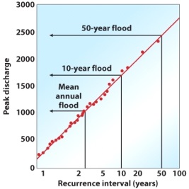
A) 2 years
B) 5 years
C) 10 years
D) 20 years
E) 50 years
A) 2 years
B) 5 years
C) 10 years
D) 20 years
E) 50 years
سؤال
سؤال
سؤال
سؤال
From the diagram,what is the peak discharge if the recurrence interval is 50 years? 
A) 3000
B) 2500
C) 2000
D) 500
E) 0
A) 3000
B) 2500
C) 2000
D) 500
E) 0
سؤال
سؤال
سؤال
سؤال
سؤال
سؤال
سؤال
سؤال
سؤال
سؤال
سؤال
سؤال
سؤال
سؤال
سؤال
سؤال
سؤال
سؤال
سؤال
سؤال
سؤال
سؤال
سؤال
سؤال
سؤال
سؤال
سؤال
سؤال
سؤال
سؤال
سؤال
سؤال
سؤال
سؤال
سؤال
سؤال
سؤال
سؤال
سؤال
سؤال
سؤال
سؤال
سؤال
سؤال
سؤال
سؤال
سؤال
سؤال

فتح الحزمة
قم بالتسجيل لفتح البطاقات في هذه المجموعة!
Unlock Deck
Unlock Deck
1/125
العب
ملء الشاشة (f)
Deck 16: Fluvial Systems and Landforms
1
Typically,higher-order streams contain ________ water than lower-order streams.
A) more
B) less
C) varying amounts
D) the same amount
E) unknown (it is not possible to tell from the given information)
A) more
B) less
C) varying amounts
D) the same amount
E) unknown (it is not possible to tell from the given information)
A
2
As a general rule,there is a(n)__________ relationship between increased stream order and stream size.
A) neutral
B) negative
C) positive
D) floating
E) exponential
A) neutral
B) negative
C) positive
D) floating
E) exponential
C
3
What does the v term in the stream discharge equation ()represent?
A) depth
B) channel width
C) velocity
D) slope
E) total discharge
A) depth
B) channel width
C) velocity
D) slope
E) total discharge
C
4
Ranking streams based on their size is called
A) stream sequence.
B) stream order.
C) ephemeral order.
D) drainage order.
E) perennial order.
A) stream sequence.
B) stream order.
C) ephemeral order.
D) drainage order.
E) perennial order.
فتح الحزمة
افتح القفل للوصول البطاقات البالغ عددها 125 في هذه المجموعة.
فتح الحزمة
k this deck
5
When the water level in a lake or pond reaches a sufficient depth,it may spill over at a low spot on the landscape.This is called
A) a perennial stream.
B) an ephemeral stream.
C) an outlet.
D) runoff.
E) a trunk.
A) a perennial stream.
B) an ephemeral stream.
C) an outlet.
D) runoff.
E) a trunk.
فتح الحزمة
افتح القفل للوصول البطاقات البالغ عددها 125 في هذه المجموعة.
فتح الحزمة
k this deck
6
The place where two streams join together is called a
A) trunk stream.
B) tributary.
C) confluence.
D) drainage divide.
E) divergence.
A) trunk stream.
B) tributary.
C) confluence.
D) drainage divide.
E) divergence.
فتح الحزمة
افتح القفل للوصول البطاقات البالغ عددها 125 في هذه المجموعة.
فتح الحزمة
k this deck
7
What does the d term in the stream discharge equation ()stand for?
A) depth
B) channel width
C) velocity
D) slope
E) total discharge
A) depth
B) channel width
C) velocity
D) slope
E) total discharge
فتح الحزمة
افتح القفل للوصول البطاقات البالغ عددها 125 في هذه المجموعة.
فتح الحزمة
k this deck
8
What does the s term in the stream discharge equation ()represent?
A) depth
B) channel width
C) velocity
D) slope
E) total discharge
A) depth
B) channel width
C) velocity
D) slope
E) total discharge
فتح الحزمة
افتح القفل للوصول البطاقات البالغ عددها 125 في هذه المجموعة.
فتح الحزمة
k this deck
9
____[1]____ streams flow all year long,whereas ____[2]____ streams flow for only a short period of time.
Answer 1 Choices:
Ephemeral
Perennial
Answer 2 Choices
ephemeral
outlet
perennial
runoff
Answer 1 Choices:
Ephemeral
Perennial
Answer 2 Choices
ephemeral
outlet
perennial
runoff
فتح الحزمة
افتح القفل للوصول البطاقات البالغ عددها 125 في هذه المجموعة.
فتح الحزمة
k this deck
10
__________ occurs most commonly in association with wet periods when soils are saturated and pore spaces can no longer absorb additional precipitation.
A) Wilting point
B) Runoff
C) Capillary drainage
D) A tributary
E) A confluence
A) Wilting point
B) Runoff
C) Capillary drainage
D) A tributary
E) A confluence
فتح الحزمة
افتح القفل للوصول البطاقات البالغ عددها 125 في هذه المجموعة.
فتح الحزمة
k this deck
11
When two streams of the same order merge,the new stream is
A) the same number.
B) the next stream order higher.
C) the next stream order lower.
D) the sum of the two streams.
E) It depends on the type of drainage pattern.
A) the same number.
B) the next stream order higher.
C) the next stream order lower.
D) the sum of the two streams.
E) It depends on the type of drainage pattern.
فتح الحزمة
افتح القفل للوصول البطاقات البالغ عددها 125 في هذه المجموعة.
فتح الحزمة
k this deck
12
__________ refers to the concentration of natural drainage channels in a given area.
A) A tributary
B) Drainage density
C) A drainage basin
D) A confluence
E) Stream order
A) A tributary
B) Drainage density
C) A drainage basin
D) A confluence
E) Stream order
فتح الحزمة
افتح القفل للوصول البطاقات البالغ عددها 125 في هذه المجموعة.
فتح الحزمة
k this deck
13
This value is calculated by dividing the total length of all streams in the basin by the area of the basin.
A) drainage multiplier
B) river density
C) stream order
D) drainage density
E) hydraulic geometry
A) drainage multiplier
B) river density
C) stream order
D) drainage density
E) hydraulic geometry
فتح الحزمة
افتح القفل للوصول البطاقات البالغ عددها 125 في هذه المجموعة.
فتح الحزمة
k this deck
14
The study of flowing water on Earth's surface is called
A) hydraulic geometry.
B) rhine hydrology.
C) stream hydrology.
D) runoff analysis.
E) stream discharge.
A) hydraulic geometry.
B) rhine hydrology.
C) stream hydrology.
D) runoff analysis.
E) stream discharge.
فتح الحزمة
افتح القفل للوصول البطاقات البالغ عددها 125 في هذه المجموعة.
فتح الحزمة
k this deck
15
What does the Q term represent in the stream discharge equation ()?
A) depth
B) channel width
C) velocity
D) slope
E) total discharge
A) depth
B) channel width
C) velocity
D) slope
E) total discharge
فتح الحزمة
افتح القفل للوصول البطاقات البالغ عددها 125 في هذه المجموعة.
فتح الحزمة
k this deck
16
_______________ occurs when water flows across the surface in sheets toward a drain.
A) Through runoff
B) Outlet runoff
C) Sheet runoff
D) Drainage runoff
E) Ephemeral drainage
A) Through runoff
B) Outlet runoff
C) Sheet runoff
D) Drainage runoff
E) Ephemeral drainage
فتح الحزمة
افتح القفل للوصول البطاقات البالغ عددها 125 في هذه المجموعة.
فتح الحزمة
k this deck
17
What does the w term in the stream discharge equation ()stand for?
A) depth
B) channel width
C) velocity
D) slope
E) total discharge
A) depth
B) channel width
C) velocity
D) slope
E) total discharge
فتح الحزمة
افتح القفل للوصول البطاقات البالغ عددها 125 في هذه المجموعة.
فتح الحزمة
k this deck
18
The divide that separates the Mississippi watershed draining to the Gulf of Mexico from streams that deliver runoff to the Pacific Ocean is called the _________ Divide.
A) Basin
B) North American
C) United States
D) Continental
E) Northern Hemisphere
A) Basin
B) North American
C) United States
D) Continental
E) Northern Hemisphere
فتح الحزمة
افتح القفل للوصول البطاقات البالغ عددها 125 في هذه المجموعة.
فتح الحزمة
k this deck
19
_________ means that water flows in a very irregular and disorderly way.
A) Laminar
B) Saltation
C) Turbulence
D) Aggradation
E) Degradation
A) Laminar
B) Saltation
C) Turbulence
D) Aggradation
E) Degradation
فتح الحزمة
افتح القفل للوصول البطاقات البالغ عددها 125 في هذه المجموعة.
فتح الحزمة
k this deck
20
The amount of discharge at any given place and time that is solely the product of groundwater seepage is called
A) stream flow.
B) flood stage.
C) bankfull discharge.
D) hydrologic control.
E) base flow.
A) stream flow.
B) flood stage.
C) bankfull discharge.
D) hydrologic control.
E) base flow.
فتح الحزمة
افتح القفل للوصول البطاقات البالغ عددها 125 في هذه المجموعة.
فتح الحزمة
k this deck
21
Low-lying terrain adjacent to a river that will inundate from time to time is called the
A) return period.
B) riparian corridor.
C) base flow.
D) floodplain.
E) flood stage.
A) return period.
B) riparian corridor.
C) base flow.
D) floodplain.
E) flood stage.
فتح الحزمة
افتح القفل للوصول البطاقات البالغ عددها 125 في هذه المجموعة.
فتح الحزمة
k this deck
22
__________ occurs when sediment is removed from one place through a geomorphic process.
A) Erosion
B) Deposition
C) Transformation
D) Translation
E) Subduction
A) Erosion
B) Deposition
C) Transformation
D) Translation
E) Subduction
فتح الحزمة
افتح القفل للوصول البطاقات البالغ عددها 125 في هذه المجموعة.
فتح الحزمة
k this deck
23
The level at which stream discharge can begin to spill out of the channel into the surrounding area is termed
A) stream flow.
B) flood stage.
C) bankfull discharge.
D) hydrologic control.
E) base flow.
A) stream flow.
B) flood stage.
C) bankfull discharge.
D) hydrologic control.
E) base flow.
فتح الحزمة
افتح القفل للوصول البطاقات البالغ عددها 125 في هذه المجموعة.
فتح الحزمة
k this deck
24
_________ are the most active zones of fluvial erosion due to gravity.
A) River valleys
B) Floodplains
C) Hillslopes
D) Deltas
E) Flat plateaus
A) River valleys
B) Floodplains
C) Hillslopes
D) Deltas
E) Flat plateaus
فتح الحزمة
افتح القفل للوصول البطاقات البالغ عددها 125 في هذه المجموعة.
فتح الحزمة
k this deck
25
_______ are small drainage channels that are cut into hillslopes by running water:
A) Rills
B) Colluvium
C) Stream gradation
D) Fluvial movement
E) Splash erosion
A) Rills
B) Colluvium
C) Stream gradation
D) Fluvial movement
E) Splash erosion
فتح الحزمة
افتح القفل للوصول البطاقات البالغ عددها 125 في هذه المجموعة.
فتح الحزمة
k this deck
26
The frequency of a flood event and its magnitude is known as the
A) return interval.
B) floodplain.
C) hydrologic organization.
D) water hierarchy.
E) flood order.
A) return interval.
B) floodplain.
C) hydrologic organization.
D) water hierarchy.
E) flood order.
فتح الحزمة
افتح القفل للوصول البطاقات البالغ عددها 125 في هذه المجموعة.
فتح الحزمة
k this deck
27
______________ is the graphical representation of stream discharge over a period of time.
A) Base flow
B) Flood stage
C) Bankfull discharge
D) Channel geometry
E) A stream hydrograph
A) Base flow
B) Flood stage
C) Bankfull discharge
D) Channel geometry
E) A stream hydrograph
فتح الحزمة
افتح القفل للوصول البطاقات البالغ عددها 125 في هذه المجموعة.
فتح الحزمة
k this deck
28
From the diagram,if the peak discharge is 1500,what is the recurrence interval?
A) 2 years
B) 5 years
C) 10 years
D) 20 years
E) 50 years
A) 2 years
B) 5 years
C) 10 years
D) 20 years
E) 50 years
فتح الحزمة
افتح القفل للوصول البطاقات البالغ عددها 125 في هذه المجموعة.
فتح الحزمة
k this deck
29
Stream discharge is typically expressed in
A) miles per hour.
B) kilometers per second.
C) meters per second.
D) cubic meters per second.
E) square meters per second.
A) miles per hour.
B) kilometers per second.
C) meters per second.
D) cubic meters per second.
E) square meters per second.
فتح الحزمة
افتح القفل للوصول البطاقات البالغ عددها 125 في هذه المجموعة.
فتح الحزمة
k this deck
30
Sediment that floats along in the stream is called
A) bedload.
B) suspended load.
C) dissolved load.
D) saltation.
E) rolling.
A) bedload.
B) suspended load.
C) dissolved load.
D) saltation.
E) rolling.
فتح الحزمة
افتح القفل للوصول البطاقات البالغ عددها 125 في هذه المجموعة.
فتح الحزمة
k this deck
31
Which of the following are examples of depositional landforms?
A) a gully
B) a floodplain
C) an alluvial fan
D) a ravine
E) a peak
A) a gully
B) a floodplain
C) an alluvial fan
D) a ravine
E) a peak
فتح الحزمة
افتح القفل للوصول البطاقات البالغ عددها 125 في هذه المجموعة.
فتح الحزمة
k this deck
32
From the diagram,what is the peak discharge if the recurrence interval is 50 years?
A) 3000
B) 2500
C) 2000
D) 500
E) 0
A) 3000
B) 2500
C) 2000
D) 500
E) 0
فتح الحزمة
افتح القفل للوصول البطاقات البالغ عددها 125 في هذه المجموعة.
فتح الحزمة
k this deck
33
This process occurs when the transporting agent loses power to carry the sediment.
A) erosion
B) deposition
C) transformation
D) translation
E) subduction
A) erosion
B) deposition
C) transformation
D) translation
E) subduction
فتح الحزمة
افتح القفل للوصول البطاقات البالغ عددها 125 في هذه المجموعة.
فتح الحزمة
k this deck
34
Landforms created by water in streams and rivers are called
A) peak landforms.
B) saddle landforms.
C) fluvial landforms.
D) floodplain formations.
E) alluvial fans.
A) peak landforms.
B) saddle landforms.
C) fluvial landforms.
D) floodplain formations.
E) alluvial fans.
فتح الحزمة
افتح القفل للوصول البطاقات البالغ عددها 125 في هذه المجموعة.
فتح الحزمة
k this deck
35
Mineral irons that are carried in solution and are invisible during transport are called
A) bedload.
B) suspended load.
C) dissolved load.
D) saltation.
E) rolling.
A) bedload.
B) suspended load.
C) dissolved load.
D) saltation.
E) rolling.
فتح الحزمة
افتح القفل للوصول البطاقات البالغ عددها 125 في هذه المجموعة.
فتح الحزمة
k this deck
36
This type of load transported in a river usually consists of clays and silts that are held up in the water by turbulence.
A) bedload
B) suspended load
C) dissolved load
D) saltation
E) rolling
A) bedload
B) suspended load
C) dissolved load
D) saltation
E) rolling
فتح الحزمة
افتح القفل للوصول البطاقات البالغ عددها 125 في هذه المجموعة.
فتح الحزمة
k this deck
37
The amount of discharge at which the stream channel is full is called
A) stream flow.
B) flood stage.
C) bankfull discharge.
D) hydrologic control.
E) base flow.
A) stream flow.
B) flood stage.
C) bankfull discharge.
D) hydrologic control.
E) base flow.
فتح الحزمة
افتح القفل للوصول البطاقات البالغ عددها 125 في هذه المجموعة.
فتح الحزمة
k this deck
38
When raindrops fall directly on to the soil,this process loosens,lifts,and drops sediment into new positions.
A) rills
B) colluvium
C) stream gradation
D) fluvial movement
E) splash erosion
A) rills
B) colluvium
C) stream gradation
D) fluvial movement
E) splash erosion
فتح الحزمة
افتح القفل للوصول البطاقات البالغ عددها 125 في هذه المجموعة.
فتح الحزمة
k this deck
39
Typically,when a stream reaches its ultimate base level,the location is called
A) the source.
B) the river mouth.
C) the alluvial end point.
D) a fan apex.
E) a sorted feature.
A) the source.
B) the river mouth.
C) the alluvial end point.
D) a fan apex.
E) a sorted feature.
فتح الحزمة
افتح القفل للوصول البطاقات البالغ عددها 125 في هذه المجموعة.
فتح الحزمة
k this deck
40
___________ is sediment deposited by a stream.
A) Alluvium
B) An alluvial terrace
C) An unpaired terrace
D) A talus fan
E) Colluvium
A) Alluvium
B) An alluvial terrace
C) An unpaired terrace
D) A talus fan
E) Colluvium
فتح الحزمة
افتح القفل للوصول البطاقات البالغ عددها 125 في هذه المجموعة.
فتح الحزمة
k this deck
41
The largest single curtain of falling water in the world is
A) Niagara Falls.
B) Angel Falls.
C) Iguacu Falls.
D) Victoria Falls.
E) Tuscaloosa Falls.
A) Niagara Falls.
B) Angel Falls.
C) Iguacu Falls.
D) Victoria Falls.
E) Tuscaloosa Falls.
فتح الحزمة
افتح القفل للوصول البطاقات البالغ عددها 125 في هذه المجموعة.
فتح الحزمة
k this deck
42
A(n)_________ occurs when centrifugal force associated with the current flowing around a meander bend carries the main current outside of the curve.
A) cutbank
B) point bar
C) thalweg
D) oxbow lake
E) natural levee
A) cutbank
B) point bar
C) thalweg
D) oxbow lake
E) natural levee
فتح الحزمة
افتح القفل للوصول البطاقات البالغ عددها 125 في هذه المجموعة.
فتح الحزمة
k this deck
43
This type of sediment transport moves large particles such as sand and gravel by rolling,sliding,or bouncing them along the channel bed.
A) bedload
B) suspended load
C) dissolved load
D) saltation
E) rolling
A) bedload
B) suspended load
C) dissolved load
D) saltation
E) rolling
فتح الحزمة
افتح القفل للوصول البطاقات البالغ عددها 125 في هذه المجموعة.
فتح الحزمة
k this deck
44
A steep slope created as a result of erosion undercutting the outside curve in a stream meander is called a(n)
A) cutbank.
B) point bar.
C) thalweg.
D) oxbow lake.
E) natural levee.
A) cutbank.
B) point bar.
C) thalweg.
D) oxbow lake.
E) natural levee.
فتح الحزمة
افتح القفل للوصول البطاقات البالغ عددها 125 في هذه المجموعة.
فتح الحزمة
k this deck
45
This is a fan-shaped landform of low relief that forms where a stream flows out of an area of high relief into a broad,open plain where deposition occurs.
A) alluvium
B) an alluvial terrace
C) an unpaired terrace
D) an alluvial fan
E) colluvium
A) alluvium
B) an alluvial terrace
C) an unpaired terrace
D) an alluvial fan
E) colluvium
فتح الحزمة
افتح القفل للوصول البطاقات البالغ عددها 125 في هذه المجموعة.
فتح الحزمة
k this deck
46
This is the lowest level at which a stream can no longer lower its bed because it flows into the ocean,lake,or another stream.
A) a waterfall
B) a knickpoint
C) base level
D) a longitudinal profile
E) an artesian well
A) a waterfall
B) a knickpoint
C) base level
D) a longitudinal profile
E) an artesian well
فتح الحزمة
افتح القفل للوصول البطاقات البالغ عددها 125 في هذه المجموعة.
فتح الحزمة
k this deck
47
The topographic lowering of a stream channel through stream erosion is called
A) a braided stream.
B) a graded stream.
C) degradation.
D) a meandering stream.
E) aggradation.
A) a braided stream.
B) a graded stream.
C) degradation.
D) a meandering stream.
E) aggradation.
فتح الحزمة
افتح القفل للوصول البطاقات البالغ عددها 125 في هذه المجموعة.
فتح الحزمة
k this deck
48
A level,steplike landform that develops when a stream erodes its bed so that an essentially horizontal surface is raised relative to the channel is called
A) alluvium.
B) an alluvial terrace.
C) an unpaired terrace.
D) an alluvial fan.
E) colluviums.
A) alluvium.
B) an alluvial terrace.
C) an unpaired terrace.
D) an alluvial fan.
E) colluviums.
فتح الحزمة
افتح القفل للوصول البطاقات البالغ عددها 125 في هذه المجموعة.
فتح الحزمة
k this deck
49
When alluvium accumulates as a long,curving deposit of sediment on the inside of a stream meander,it is called a(n)
A) cutbank.
B) point bar.
C) thalweg.
D) oxbow lake.
E) natural levee.
A) cutbank.
B) point bar.
C) thalweg.
D) oxbow lake.
E) natural levee.
فتح الحزمة
افتح القفل للوصول البطاقات البالغ عددها 125 في هذه المجموعة.
فتح الحزمة
k this deck
50
___________ is a network of converging and diverging stream channels within an individual stream system that are separated from each other by deposits of sand and gravel.
A) A braided stream
B) A graded stream
C) A longitudinal profile
D) A meandering stream
E) Degradation
A) A braided stream
B) A graded stream
C) A longitudinal profile
D) A meandering stream
E) Degradation
فتح الحزمة
افتح القفل للوصول البطاقات البالغ عددها 125 في هذه المجموعة.
فتح الحزمة
k this deck
51
__________ floodplains are regions near a river that is low and frequently flooded.
A) River
B) Backswamp
C) Active
D) Entrenched
E) Alluvium
A) River
B) Backswamp
C) Active
D) Entrenched
E) Alluvium
فتح الحزمة
افتح القفل للوصول البطاقات البالغ عددها 125 في هذه المجموعة.
فتح الحزمة
k this deck
52
The progressive accumulation of sediment along or within a stream is called
A) a braided stream.
B) a graded stream.
C) aggradation.
D) downcutting.
E) degradation.
A) a braided stream.
B) a graded stream.
C) aggradation.
D) downcutting.
E) degradation.
فتح الحزمة
افتح القفل للوصول البطاقات البالغ عددها 125 في هذه المجموعة.
فتح الحزمة
k this deck
53
A river or small stream that curves back and forth across its valley is called a(n)
A) exotic stream.
B) graded stream.
C) longitudinal profile.
D) meandering stream.
E) aggradation.
A) exotic stream.
B) graded stream.
C) longitudinal profile.
D) meandering stream.
E) aggradation.
فتح الحزمة
افتح القفل للوصول البطاقات البالغ عددها 125 في هذه المجموعة.
فتح الحزمة
k this deck
54
A(n)_______________ occurs when a portion of an abandoned stream channel is cut off from the rest of the stream by the meandering process and is filled with stagnant water.
A) cutbank
B) point bar
C) thalweg
D) oxbow lake
E) anatural levee
A) cutbank
B) point bar
C) thalweg
D) oxbow lake
E) anatural levee
فتح الحزمة
افتح القفل للوصول البطاقات البالغ عددها 125 في هذه المجموعة.
فتح الحزمة
k this deck
55
_____________ is a stream that is capable of transporting the average sediment load provided to it over time.
A) A braided stream
B) A graded stream
C) A longitudinal profile
D) A meandering stream
E) Aggradation
A) A braided stream
B) A graded stream
C) A longitudinal profile
D) A meandering stream
E) Aggradation
فتح الحزمة
افتح القفل للوصول البطاقات البالغ عددها 125 في هذه المجموعة.
فتح الحزمة
k this deck
56
A graph that illustrates the change in stream gradient in cross section along a stream from its source to its mouth is called a(n)
A) braided stream.
B) graded stream.
C) longitudinal profile.
D) meandering stream.
E) aggradation.
A) braided stream.
B) graded stream.
C) longitudinal profile.
D) meandering stream.
E) aggradation.
فتح الحزمة
افتح القفل للوصول البطاقات البالغ عددها 125 في هذه المجموعة.
فتح الحزمة
k this deck
57
This is a small ridge that develops along the channel of a stream through the deposition of relatively coarse sediment when flooding occurs.
A) a cutbank
B) a point bar
C) a thalweg
D) an oxbow lake
E) a natural levee
A) a cutbank
B) a point bar
C) a thalweg
D) an oxbow lake
E) a natural levee
فتح الحزمة
افتح القفل للوصول البطاقات البالغ عددها 125 في هذه المجموعة.
فتح الحزمة
k this deck
58
The topographic lowering of a stream channel by stream erosion is called
A) degradation.
B) downcutting.
C) aggradation.
D) progradation.
E) meandering.
A) degradation.
B) downcutting.
C) aggradation.
D) progradation.
E) meandering.
فتح الحزمة
افتح القفل للوصول البطاقات البالغ عددها 125 في هذه المجموعة.
فتح الحزمة
k this deck
59
When water slows at the edges of the stream bank,it deposits materials. This process will form a(n)
A) natural levee.
B) backswamp.
C) floodplain.
D) meander scar.
E) oxbow lake.
A) natural levee.
B) backswamp.
C) floodplain.
D) meander scar.
E) oxbow lake.
فتح الحزمة
افتح القفل للوصول البطاقات البالغ عددها 125 في هذه المجموعة.
فتح الحزمة
k this deck
60
The ___________ is a stream that can transport no more material than it is currently carrying.
A) entrained stream
B) aggraded stream
C) graded stream
D) competent stream
E) profiled stream
A) entrained stream
B) aggraded stream
C) graded stream
D) competent stream
E) profiled stream
فتح الحزمة
افتح القفل للوصول البطاقات البالغ عددها 125 في هذه المجموعة.
فتح الحزمة
k this deck
61
Which of the following are transport mechanisms of streams?
A) colluvial load
B) bedload
C) dissolved load
D) suspended load
E) saltation
A) colluvial load
B) bedload
C) dissolved load
D) suspended load
E) saltation
فتح الحزمة
افتح القفل للوصول البطاقات البالغ عددها 125 في هذه المجموعة.
فتح الحزمة
k this deck
62
A(n)__________is a barrier that blocks or restricts the downstream movement of a stream.
A) dam
B) natural levee
C) artificial levee
D) waterfall
E) delta
A) dam
B) natural levee
C) artificial levee
D) waterfall
E) delta
فتح الحزمة
افتح القفل للوصول البطاقات البالغ عددها 125 في هذه المجموعة.
فتح الحزمة
k this deck
63
Rivers that contain water for only a short period of time are called ephemeral streams.
فتح الحزمة
افتح القفل للوصول البطاقات البالغ عددها 125 في هذه المجموعة.
فتح الحزمة
k this deck
64
Runoff that flows in sheets toward a drain of some sort is called sheet runoff.
فتح الحزمة
افتح القفل للوصول البطاقات البالغ عددها 125 في هذه المجموعة.
فتح الحزمة
k this deck
65
A drainage system that is typically associated with parts of the Appalachian Mountains where there are ridges and valleys is
A) dendritic.
B) rectangular.
C) trellis.
D) radial.
E) parallel.
A) dendritic.
B) rectangular.
C) trellis.
D) radial.
E) parallel.
فتح الحزمة
افتح القفل للوصول البطاقات البالغ عددها 125 في هذه المجموعة.
فتح الحزمة
k this deck
66
Streams with water flowing in them all year long are called ephemeral streams.
فتح الحزمة
افتح القفل للوصول البطاقات البالغ عددها 125 في هذه المجموعة.
فتح الحزمة
k this deck
67
Another name for a watershed is
A) drainage basin.
B) drainage divide.
C) interfluve
D) confluence.
E) tributary.
A) drainage basin.
B) drainage divide.
C) interfluve
D) confluence.
E) tributary.
فتح الحزمة
افتح القفل للوصول البطاقات البالغ عددها 125 في هذه المجموعة.
فتح الحزمة
k this deck
68
The most common type of drainage system is
A) dendritic.
B) rectangular.
C) trellis.
D) radial.
E) parallel.
A) dendritic.
B) rectangular.
C) trellis.
D) radial.
E) parallel.
فتح الحزمة
افتح القفل للوصول البطاقات البالغ عددها 125 في هذه المجموعة.
فتح الحزمة
k this deck
69
The hydrology in an urban system is considered ________ because these environments typically respond more quickly to the addition of water into the system.
A) temperamental
B) responsive
C) eager
D) flashy
E) sensitive
A) temperamental
B) responsive
C) eager
D) flashy
E) sensitive
فتح الحزمة
افتح القفل للوصول البطاقات البالغ عددها 125 في هذه المجموعة.
فتح الحزمة
k this deck
70
When water overbanks repeatedly in an area,that area is called a(n)
A) natural levee.
B) backswamp.
C) floodplain
D) meander scar.
E) oxbow lake
A) natural levee.
B) backswamp.
C) floodplain
D) meander scar.
E) oxbow lake
فتح الحزمة
افتح القفل للوصول البطاقات البالغ عددها 125 في هذه المجموعة.
فتح الحزمة
k this deck
71
The area between gullies and streams called the __________
A) drainage basin.
B) drainage divide.
C) interfluve.
D) confluence.
E) tributary.
A) drainage basin.
B) drainage divide.
C) interfluve.
D) confluence.
E) tributary.
فتح الحزمة
افتح القفل للوصول البطاقات البالغ عددها 125 في هذه المجموعة.
فتح الحزمة
k this deck
72
When a meandering stream moves its channel,forms a lake,and then it fills in with sediment,it is called a(n)
A) natural levee.
B) backswamp.
C) floodplain.
D) meander scar.
E) oxbow lake.
A) natural levee.
B) backswamp.
C) floodplain.
D) meander scar.
E) oxbow lake.
فتح الحزمة
افتح القفل للوصول البطاقات البالغ عددها 125 في هذه المجموعة.
فتح الحزمة
k this deck
73
A drainage system that is typically associated with a volcano is called
A) dendritic.
B) rectangular.
C) trellis.
D) radial.
E) parallel.
A) dendritic.
B) rectangular.
C) trellis.
D) radial.
E) parallel.
فتح الحزمة
افتح القفل للوصول البطاقات البالغ عددها 125 في هذه المجموعة.
فتح الحزمة
k this deck
74
What it the body of stagnant water called that forms on a floodplain when a stream tops its banks?
A) natural levee.
B) backswamp.
C) floodplain
D) meander scar
E) oxbow lake.
A) natural levee.
B) backswamp.
C) floodplain
D) meander scar
E) oxbow lake.
فتح الحزمة
افتح القفل للوصول البطاقات البالغ عددها 125 في هذه المجموعة.
فتح الحزمة
k this deck
75
________ is a low,level plain that develops where a stream flows into a relatively still body of water so that its velocity decreases and alluvial deposition occurs.
A) The source
B) The river mouth
C) The alluvial end point
D) A fan apex
E) A delta
A) The source
B) The river mouth
C) The alluvial end point
D) A fan apex
E) A delta
فتح الحزمة
افتح القفل للوصول البطاقات البالغ عددها 125 في هذه المجموعة.
فتح الحزمة
k this deck
76
________ is a term that describes the joining of two streams together.
A) Drainage basin
B) Drainage divide
C) Interfluve
D) Confluence
E) Tributary
A) Drainage basin
B) Drainage divide
C) Interfluve
D) Confluence
E) Tributary
فتح الحزمة
افتح القفل للوصول البطاقات البالغ عددها 125 في هذه المجموعة.
فتح الحزمة
k this deck
77
A(n)_____________ is an engineered structure along a river that effectively raises the height of the river bank and thus confines flood discharge.
A) dam
B) natural levee
C) artificial levee
D) waterfall
E) delta
A) dam
B) natural levee
C) artificial levee
D) waterfall
E) delta
فتح الحزمة
افتح القفل للوصول البطاقات البالغ عددها 125 في هذه المجموعة.
فتح الحزمة
k this deck
78
A rapid or waterfall is known as a
A) longitudinal profile.
B) base level.
C) cutbank.
D) knickpoint
E) graded stream.
A) longitudinal profile.
B) base level.
C) cutbank.
D) knickpoint
E) graded stream.
فتح الحزمة
افتح القفل للوصول البطاقات البالغ عددها 125 في هذه المجموعة.
فتح الحزمة
k this deck
79
An area of raised land that forms a separating rim between two adjacent drainage basins is called a drainage basin.
فتح الحزمة
افتح القفل للوصول البطاقات البالغ عددها 125 في هذه المجموعة.
فتح الحزمة
k this deck
80
The level at which stream discharge can begin to spill out of the channel into the surrounding area is called flood stage.
فتح الحزمة
افتح القفل للوصول البطاقات البالغ عددها 125 في هذه المجموعة.
فتح الحزمة
k this deck
فتح الحزمة
افتح القفل للوصول البطاقات البالغ عددها 125 في هذه المجموعة.


