Deck 19: Coastal Processes and Landforms
ملء الشاشة (f)
سؤال
سؤال
سؤال
سؤال
سؤال
سؤال
سؤال
سؤال
سؤال
سؤال
سؤال
سؤال
سؤال
سؤال
سؤال
سؤال
سؤال
سؤال
سؤال
سؤال
سؤال
سؤال
Which letter in the diagram represents surf? 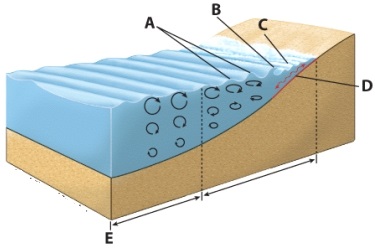
A) A
B) B
C) C
D) D
A) A
B) B
C) C
D) D
سؤال
سؤال
Which letter in the diagram represents breakers? 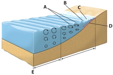
A) A
B) B
C) C
D) D
A) A
B) B
C) C
D) D
سؤال
سؤال
سؤال
سؤال
سؤال
سؤال
سؤال
سؤال
سؤال
سؤال
سؤال
سؤال
سؤال
سؤال
سؤال
سؤال
سؤال
سؤال
سؤال
سؤال
سؤال
سؤال
From the accompanying diagram,which letter represents the incoming waves? 
A) A
B) B
C) C
D) D
E) A and C only
A) A
B) B
C) C
D) D
E) A and C only
سؤال
سؤال
سؤال
سؤال
From the accompanying diagram,which letter represents the headland? 
A) A
B) B
C) C
D) D
E) A and B
A) A
B) B
C) C
D) D
E) A and B
سؤال
سؤال
سؤال
سؤال
سؤال
سؤال
سؤال
From the accompanying diagram,which letter represents the pocket beach? 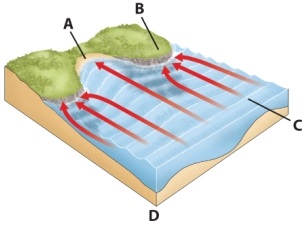
A) A
B) B
C) C
D) D
E) A and D
A) A
B) B
C) C
D) D
E) A and D
سؤال
سؤال
سؤال
سؤال
سؤال
سؤال
سؤال
سؤال
سؤال
سؤال
سؤال
سؤال
سؤال
سؤال
سؤال
سؤال
سؤال
سؤال
سؤال
سؤال
سؤال
سؤال
سؤال

فتح الحزمة
قم بالتسجيل لفتح البطاقات في هذه المجموعة!
Unlock Deck
Unlock Deck
1/125
العب
ملء الشاشة (f)
Deck 19: Coastal Processes and Landforms
1
The water level during the Wisconsin glacial period was ________ than current levels.
A) slightly higher
B) lower
C) the same
D) not enough information to tell
E) much higher
A) slightly higher
B) lower
C) the same
D) not enough information to tell
E) much higher
B
2
A saltwater body of water that is partially enclosed by land is called
A) ocean.
B) sea.
C) gulf.
D) bay.
E) estuary.
A) ocean.
B) sea.
C) gulf.
D) bay.
E) estuary.
B
3
Fluctuations in sea level associated with adjustments in the hydrologic cycle are called _________ change.
A) hydrologic
B) salinity
C) brackish
D) eustatic
E) static
A) hydrologic
B) salinity
C) brackish
D) eustatic
E) static
D
4
Water that has a salinity between 15 and 35 parts per thousand is considered
A) saline.
B) brine.
C) brackish.
D) eustatic.
E) ria.
A) saline.
B) brine.
C) brackish.
D) eustatic.
E) ria.
فتح الحزمة
افتح القفل للوصول البطاقات البالغ عددها 125 في هذه المجموعة.
فتح الحزمة
k this deck
5
Global salinity of the world oceans varies between 34 and 37 parts per
A) hundred.
B) million.
C) trillion.
D) thousand.
E) billion.
A) hundred.
B) million.
C) trillion.
D) thousand.
E) billion.
فتح الحزمة
افتح القفل للوصول البطاقات البالغ عددها 125 في هذه المجموعة.
فتح الحزمة
k this deck
6
When water has a salinity of greater than 35 parts per thousand,the water is considered
A) saline.
B) brine.
C) brackish.
D) eustatic.
E) ria.
A) saline.
B) brine.
C) brackish.
D) eustatic.
E) ria.
فتح الحزمة
افتح القفل للوصول البطاقات البالغ عددها 125 في هذه المجموعة.
فتح الحزمة
k this deck
7
A relatively small body of salt water that is surrounded by land on three sides and opens to a see or ocean is called a(n)
A) ocean.
B) sea.
C) gulf.
D) bay.
E) estuary
A) ocean.
B) sea.
C) gulf.
D) bay.
E) estuary
فتح الحزمة
افتح القفل للوصول البطاقات البالغ عددها 125 في هذه المجموعة.
فتح الحزمة
k this deck
8
The Moon's gravitational pull is responsible for __________ of the ocean's daily tides than the Sun's gravitational pull.
A) slightly less
B) much less
C) more
D) the same percentage
E) about 50% less
A) slightly less
B) much less
C) more
D) the same percentage
E) about 50% less
فتح الحزمة
افتح القفل للوصول البطاقات البالغ عددها 125 في هذه المجموعة.
فتح الحزمة
k this deck
9
The concentration of dissolved solids in water,measured in parts per thousand,is called
A) brackish.
B) brine.
C) salinity.
D) charge.
E) specific heat.
A) brackish.
B) brine.
C) salinity.
D) charge.
E) specific heat.
فتح الحزمة
افتح القفل للوصول البطاقات البالغ عددها 125 في هذه المجموعة.
فتح الحزمة
k this deck
10
A former glaciated valley along the coast that is flooded by rising sea level is termed a(n)
A) ria.
B) fjord.
C) bay.
D) estuary.
E) gulf.
A) ria.
B) fjord.
C) bay.
D) estuary.
E) gulf.
فتح الحزمة
افتح القفل للوصول البطاقات البالغ عددها 125 في هذه المجموعة.
فتح الحزمة
k this deck
11
_______ are regular and predictable oscillations that occur with respect to the level of the world's oceans.
A) Waves
B) Eustatic changes
C) Tides
D) Breakers
E) Ocean oscillations
A) Waves
B) Eustatic changes
C) Tides
D) Breakers
E) Ocean oscillations
فتح الحزمة
افتح القفل للوصول البطاقات البالغ عددها 125 في هذه المجموعة.
فتح الحزمة
k this deck
12
The largest ocean on Earth is the
A) Atlantic Ocean.
B) Indian Ocean.
C) Pacific Ocean.
D) Arctic Ocean.
E) Southern Ocean.
A) Atlantic Ocean.
B) Indian Ocean.
C) Pacific Ocean.
D) Arctic Ocean.
E) Southern Ocean.
فتح الحزمة
افتح القفل للوصول البطاقات البالغ عددها 125 في هذه المجموعة.
فتح الحزمة
k this deck
13
The "newest" body of water recognized to be an ocean is the
A) Atlantic Ocean.
B) Indian Ocean.
C) Pacific Ocean.
D) Arctic Ocean
E) Southern Ocean.
A) Atlantic Ocean.
B) Indian Ocean.
C) Pacific Ocean.
D) Arctic Ocean
E) Southern Ocean.
فتح الحزمة
افتح القفل للوصول البطاقات البالغ عددها 125 في هذه المجموعة.
فتح الحزمة
k this deck
14
The _______ Sea is located off the coast of Antarctica.
A) Sargasso
B) Banda
C) Beaufort
D) Chukchi
E) Weddell
A) Sargasso
B) Banda
C) Beaufort
D) Chukchi
E) Weddell
فتح الحزمة
افتح القفل للوصول البطاقات البالغ عددها 125 في هذه المجموعة.
فتح الحزمة
k this deck
15
The entire body of salt water that covers about 71% of the Earth is called _________.
A) the sea.
B) the ocean.
C) a gulf.
D) a bay.
E) a saline lake.
A) the sea.
B) the ocean.
C) a gulf.
D) a bay.
E) a saline lake.
فتح الحزمة
افتح القفل للوصول البطاقات البالغ عددها 125 في هذه المجموعة.
فتح الحزمة
k this deck
16
A former river valley along the coast that is flooded by rising sea level is called a(n)
A) ria.
B) fjord.
C) bay.
D) estuary.
E) gulf.
A) ria.
B) fjord.
C) bay.
D) estuary.
E) gulf.
فتح الحزمة
افتح القفل للوصول البطاقات البالغ عددها 125 في هذه المجموعة.
فتح الحزمة
k this deck
17
The Sun's gravitational pull is responsible for ____% of the ocean's daily tides.
A) 19
B) 20
C) 44
D) 8.2
E) 56
A) 19
B) 20
C) 44
D) 8.2
E) 56
فتح الحزمة
افتح القفل للوصول البطاقات البالغ عددها 125 في هذه المجموعة.
فتح الحزمة
k this deck
18
Oceans cover about _____% surface of the Earth.
A) 55
B) 62
C) 71
D) 83
E) 94
A) 55
B) 62
C) 71
D) 83
E) 94
فتح الحزمة
افتح القفل للوصول البطاقات البالغ عددها 125 في هذه المجموعة.
فتح الحزمة
k this deck
19
There are ____ geographic divisions of the world ocean.
A) two
B) three
C) five
D) six
E) seven
A) two
B) three
C) five
D) six
E) seven
فتح الحزمة
افتح القفل للوصول البطاقات البالغ عددها 125 في هذه المجموعة.
فتح الحزمة
k this deck
20
The Moon's gravitational pull is responsible for ____% of the ocean's daily tides.
A) 19
B) 20
C) 44
D) 8.2
E) 56
A) 19
B) 20
C) 44
D) 8.2
E) 56
فتح الحزمة
افتح القفل للوصول البطاقات البالغ عددها 125 في هذه المجموعة.
فتح الحزمة
k this deck
21
_____________ refer(s)to the vertical distance between the wave crest and the level of water if it were still.
A) Wave height
B) Swells
C) Wave amplitude
D) Wavelength
E) Wave base
A) Wave height
B) Swells
C) Wave amplitude
D) Wavelength
E) Wave base
فتح الحزمة
افتح القفل للوصول البطاقات البالغ عددها 125 في هذه المجموعة.
فتح الحزمة
k this deck
22
Which letter in the diagram represents surf?
A) A
B) B
C) C
D) D
A) A
B) B
C) C
D) D
فتح الحزمة
افتح القفل للوصول البطاقات البالغ عددها 125 في هذه المجموعة.
فتح الحزمة
k this deck
23
After the high point of a wave passes,the water lowers into the
A) wave trough.
B) wave crest.
C) wave base.
D) wave amplitude.
E) wave height.
A) wave trough.
B) wave crest.
C) wave base.
D) wave amplitude.
E) wave height.
فتح الحزمة
افتح القفل للوصول البطاقات البالغ عددها 125 في هذه المجموعة.
فتح الحزمة
k this deck
24
Which letter in the diagram represents breakers?
A) A
B) B
C) C
D) D
A) A
B) B
C) C
D) D
فتح الحزمة
افتح القفل للوصول البطاقات البالغ عددها 125 في هذه المجموعة.
فتح الحزمة
k this deck
25
The alternating cycles of high and low tides last roughly ____ hours.
A) 6
B) 8
C) 10
D) 12
E) 16
A) 6
B) 8
C) 10
D) 12
E) 16
فتح الحزمة
افتح القفل للوصول البطاقات البالغ عددها 125 في هذه المجموعة.
فتح الحزمة
k this deck
26
Sediment transported in the surf zone by swash and backwash,which form due to the oblique angle of the breaking waves,is called:
A) beach drift.
B) lateral drift.
C) littoral drift.
D) longshore current.
E) none of these
A) beach drift.
B) lateral drift.
C) littoral drift.
D) longshore current.
E) none of these
فتح الحزمة
افتح القفل للوصول البطاقات البالغ عددها 125 في هذه المجموعة.
فتح الحزمة
k this deck
27
_______ are oscillations in a body of water that form due to the wind blowing across the surface of the water.
A) Rip tides
B) Tsunamis
C) Waves
D) Breakers
E) None of these
A) Rip tides
B) Tsunamis
C) Waves
D) Breakers
E) None of these
فتح الحزمة
افتح القفل للوصول البطاقات البالغ عددها 125 في هذه المجموعة.
فتح الحزمة
k this deck
28
The distance of unimpeded air flow along the surface of a body of water is called:
A) fetch
B) stretch
C) wind strength
D) wind duration
E) swell
A) fetch
B) stretch
C) wind strength
D) wind duration
E) swell
فتح الحزمة
افتح القفل للوصول البطاقات البالغ عددها 125 في هذه المجموعة.
فتح الحزمة
k this deck
29
The word tsunami is Japanese meaning
A) killer wave.
B) abnormal wave.
C) enormous wave.
D) strong wave.
E) fast wave.
A) killer wave.
B) abnormal wave.
C) enormous wave.
D) strong wave.
E) fast wave.
فتح الحزمة
افتح القفل للوصول البطاقات البالغ عددها 125 في هذه المجموعة.
فتح الحزمة
k this deck
30
The lowest of high tides are called _______ tides.
A) spring
B) direct
C) neap
D) eustatic
E) opposite
A) spring
B) direct
C) neap
D) eustatic
E) opposite
فتح الحزمة
افتح القفل للوصول البطاقات البالغ عددها 125 في هذه المجموعة.
فتح الحزمة
k this deck
31
______________ is the current that develops parallel to the coast when waves approach a coast at an oblique angle.
A) Longshore current
B) Littoral current
C) Longshore drift
D) Beach current
E) Beach drift
A) Longshore current
B) Littoral current
C) Longshore drift
D) Beach current
E) Beach drift
فتح الحزمة
افتح القفل للوصول البطاقات البالغ عددها 125 في هذه المجموعة.
فتح الحزمة
k this deck
32
The horizontal distance between two successive wave crests is called the
A) wave height.
B) swells.
C) wave amplitude.
D) wavelength.
E) wave base.
A) wave height.
B) swells.
C) wave amplitude.
D) wavelength.
E) wave base.
فتح الحزمة
افتح القفل للوصول البطاقات البالغ عددها 125 في هذه المجموعة.
فتح الحزمة
k this deck
33
The processes through which sediment is transported and deposited in the shore zone are called
A) shoaling.
B) longshore drift.
C) beach drift.
D) littoral processes.
E) wave action.
A) shoaling.
B) longshore drift.
C) beach drift.
D) littoral processes.
E) wave action.
فتح الحزمة
افتح القفل للوصول البطاقات البالغ عددها 125 في هذه المجموعة.
فتح الحزمة
k this deck
34
Another name for a tsunami is a(n)
A) seismic sea wave.
B) eustatic wave.
C) grand wave.
D) ocean wave.
E) deep-water wave.
A) seismic sea wave.
B) eustatic wave.
C) grand wave.
D) ocean wave.
E) deep-water wave.
فتح الحزمة
افتح القفل للوصول البطاقات البالغ عددها 125 في هذه المجموعة.
فتح الحزمة
k this deck
35
The highest of high tides are called ______ tides.
A) spring
B) direct
C) neap
D) eustatic
E) opposite
A) spring
B) direct
C) neap
D) eustatic
E) opposite
فتح الحزمة
افتح القفل للوصول البطاقات البالغ عددها 125 في هذه المجموعة.
فتح الحزمة
k this deck
36
When the gravitational pull from the Moon pulls directly on the water body and is perpendicular to the Sun,it is called a(n)_______ tide.
A) spring
B) direct
C) neap
D) eustatic
E) opposite
A) spring
B) direct
C) neap
D) eustatic
E) opposite
فتح الحزمة
افتح القفل للوصول البطاقات البالغ عددها 125 في هذه المجموعة.
فتح الحزمة
k this deck
37
As waves move out of an area where they are generated,they continue to move forward and are known as
A) wave progressions.
B) water propagation.
C) breakers.
D) swells.
E) none of these
A) wave progressions.
B) water propagation.
C) breakers.
D) swells.
E) none of these
فتح الحزمة
افتح القفل للوصول البطاقات البالغ عددها 125 في هذه المجموعة.
فتح الحزمة
k this deck
38
The transport of sediment by longshore current is called
A) swash.
B) backwash.
C) beach drift.
D) longshore drift.
E) littoral drift.
A) swash.
B) backwash.
C) beach drift.
D) longshore drift.
E) littoral drift.
فتح الحزمة
افتح القفل للوصول البطاقات البالغ عددها 125 في هذه المجموعة.
فتح الحزمة
k this deck
39
The high spot of an individual wave is called
A) a wave trough.
B) a wave crest.
C) a wave base.
D) wave amplitude.
E) wave height.
A) a wave trough.
B) a wave crest.
C) a wave base.
D) wave amplitude.
E) wave height.
فتح الحزمة
افتح القفل للوصول البطاقات البالغ عددها 125 في هذه المجموعة.
فتح الحزمة
k this deck
40
___________ is (are)the vertical distance between the wave crest and the base of the wave trough.
A) Wave height
B) Swells
C) Wave amplitude
D) Wavelength
E) Wave base
A) Wave height
B) Swells
C) Wave amplitude
D) Wavelength
E) Wave base
فتح الحزمة
افتح القفل للوصول البطاقات البالغ عددها 125 في هذه المجموعة.
فتح الحزمة
k this deck
41
____________ is the part of the beach that lies between the beach ridge and the foredune.
A) The backshore
B) The beach ridge
C) The foreshore
D) The offshore
E) The offshore bar
A) The backshore
B) The beach ridge
C) The foreshore
D) The offshore
E) The offshore bar
فتح الحزمة
افتح القفل للوصول البطاقات البالغ عددها 125 في هذه المجموعة.
فتح الحزمة
k this deck
42
__________ is the combined movement of both longshore drift and beach drift.
A) Longshore current
B) Beach transport
C) Littoral drift
D) Combined flow
E) Swash
A) Longshore current
B) Beach transport
C) Littoral drift
D) Combined flow
E) Swash
فتح الحزمة
افتح القفل للوصول البطاقات البالغ عددها 125 في هذه المجموعة.
فتح الحزمة
k this deck
43
A portion of the coast that extends outward into a large body of water is called a
A) bay.
B) pocket beach.
C) headland.
D) spit.
E) foredune.
A) bay.
B) pocket beach.
C) headland.
D) spit.
E) foredune.
فتح الحزمة
افتح القفل للوصول البطاقات البالغ عددها 125 في هذه المجموعة.
فتح الحزمة
k this deck
44
A small island connected to a landmass by a spit is called a(n)
A) spit.
B) baymouth bar.
C) lagoon.
D) tombolo.
E) jetty.
A) spit.
B) baymouth bar.
C) lagoon.
D) tombolo.
E) jetty.
فتح الحزمة
افتح القفل للوصول البطاقات البالغ عددها 125 في هذه المجموعة.
فتح الحزمة
k this deck
45
The nearshore zone where waves break is called the
A) offshore.
B) foreshore.
C) backshore.
D) offshore bar.
E) beach ridge.
A) offshore.
B) foreshore.
C) backshore.
D) offshore bar.
E) beach ridge.
فتح الحزمة
افتح القفل للوصول البطاقات البالغ عددها 125 في هذه المجموعة.
فتح الحزمة
k this deck
46
From the accompanying diagram,which letter represents the incoming waves?
A) A
B) B
C) C
D) D
E) A and C only
A) A
B) B
C) C
D) D
E) A and C only
فتح الحزمة
افتح القفل للوصول البطاقات البالغ عددها 125 في هذه المجموعة.
فتح الحزمة
k this deck
47
The process through which a shoreline retreats through erosion is called
A) retrogradation.
B) progradation.
C) deflation.
D) wave cutting.
E) tombolo formation.
A) retrogradation.
B) progradation.
C) deflation.
D) wave cutting.
E) tombolo formation.
فتح الحزمة
افتح القفل للوصول البطاقات البالغ عددها 125 في هذه المجموعة.
فتح الحزمة
k this deck
48
A brackish body of water that lies behind a baymouth bar is called a(n)
A) spit.
B) enclosed pond.
C) lagoon.
D) tombolo.
E) jetty.
A) spit.
B) enclosed pond.
C) lagoon.
D) tombolo.
E) jetty.
فتح الحزمة
افتح القفل للوصول البطاقات البالغ عددها 125 في هذه المجموعة.
فتح الحزمة
k this deck
49
The surge of water from breaking waves onto the beach is called
A) beach flow.
B) beach drift.
C) swash.
D) backwash.
E) wave current.
A) beach flow.
B) beach drift.
C) swash.
D) backwash.
E) wave current.
فتح الحزمة
افتح القفل للوصول البطاقات البالغ عددها 125 في هذه المجموعة.
فتح الحزمة
k this deck
50
From the accompanying diagram,which letter represents the headland?
A) A
B) B
C) C
D) D
E) A and B
A) A
B) B
C) C
D) D
E) A and B
فتح الحزمة
افتح القفل للوصول البطاقات البالغ عددها 125 في هذه المجموعة.
فتح الحزمة
k this deck
51
The erosional ridge that marks the high-water line and lies at the landward margin of the foreshore is called the
A) backshore.
B) beach ridge.
C) foreshore.
D) offshore.
E) offshore bar.
A) backshore.
B) beach ridge.
C) foreshore.
D) offshore.
E) offshore bar.
فتح الحزمة
افتح القفل للوصول البطاقات البالغ عددها 125 في هذه المجموعة.
فتح الحزمة
k this deck
52
The nearshore zone that is permanently submerged is called the
A) backshore.
B) beach ridge.
C) foreshore.
D) offshore.
E) offshore bar.
A) backshore.
B) beach ridge.
C) foreshore.
D) offshore.
E) offshore bar.
فتح الحزمة
افتح القفل للوصول البطاقات البالغ عددها 125 في هذه المجموعة.
فتح الحزمة
k this deck
53
___________ is the nearshore zone that is regularly uncovered through the tidal fluctuations and movement of surf.
A) The backshore
B) The beach ridge
C) The foreshore
D) The offshore
E) The offshore bar
A) The backshore
B) The beach ridge
C) The foreshore
D) The offshore
E) The offshore bar
فتح الحزمة
افتح القفل للوصول البطاقات البالغ عددها 125 في هذه المجموعة.
فتح الحزمة
k this deck
54
After water breaking on the beach reaches its apex,it flows back to the ocean at a right angle to the shore as
A) beach flow.
B) beach drift.
C) swash.
D) backwash.
E) return current.
A) beach flow.
B) beach drift.
C) swash.
D) backwash.
E) return current.
فتح الحزمة
افتح القفل للوصول البطاقات البالغ عددها 125 في هذه المجموعة.
فتح الحزمة
k this deck
55
This is a small,linear dune that fronts the backshore.
A) the backshore
B) the foreshore
C) the dune development
D) the foredune
E) the backdune
A) the backshore
B) the foreshore
C) the dune development
D) the foredune
E) the backdune
فتح الحزمة
افتح القفل للوصول البطاقات البالغ عددها 125 في هذه المجموعة.
فتح الحزمة
k this deck
56
________ is a spit that entirely closes a bay.
A) A spit
B) A baymouth bar
C) A lagoon
D) A tombolo
E) A jetty
A) A spit
B) A baymouth bar
C) A lagoon
D) A tombolo
E) A jetty
فتح الحزمة
افتح القفل للوصول البطاقات البالغ عددها 125 في هذه المجموعة.
فتح الحزمة
k this deck
57
From the accompanying diagram,which letter represents the pocket beach?
A) A
B) B
C) C
D) D
E) A and D
A) A
B) B
C) C
D) D
E) A and D
فتح الحزمة
افتح القفل للوصول البطاقات البالغ عددها 125 في هذه المجموعة.
فتح الحزمة
k this deck
58
_______ is a linear bank of land that extends into a bay made by the deposition of longshore sediment.
A) A spit
B) A baymouth bar
C) A lagoon
D) A tombolo
E) A jetty
A) A spit
B) A baymouth bar
C) A lagoon
D) A tombolo
E) A jetty
فتح الحزمة
افتح القفل للوصول البطاقات البالغ عددها 125 في هذه المجموعة.
فتح الحزمة
k this deck
59
____________ is the outward extension of the shoreline through deposition of sediment.
A) Retrogradation
B) Progradation
C) Offshore development
D) Foreshore
E) Backshore
A) Retrogradation
B) Progradation
C) Offshore development
D) Foreshore
E) Backshore
فتح الحزمة
افتح القفل للوصول البطاقات البالغ عددها 125 في هذه المجموعة.
فتح الحزمة
k this deck
60
___________ is a small ridge on the bottom of the ocean that typically separates the offshore and foreshore.
A) The beach ridge
B) The backshore cliff
C) The offshore bar
D) The foreshore transition
E) The offshore transition
A) The beach ridge
B) The backshore cliff
C) The offshore bar
D) The foreshore transition
E) The offshore transition
فتح الحزمة
افتح القفل للوصول البطاقات البالغ عددها 125 في هذه المجموعة.
فتح الحزمة
k this deck
61
A semicircular reef that is most closely associated with degradation of volcanic islands is called a(n)
A) fringing reef.
B) barrier reef.
C) atoll.
D) lagoon.
E) coral reef.
A) fringing reef.
B) barrier reef.
C) atoll.
D) lagoon.
E) coral reef.
فتح الحزمة
افتح القفل للوصول البطاقات البالغ عددها 125 في هذه المجموعة.
فتح الحزمة
k this deck
62
A benchlike cut at the high water line along shores is called a
A) baymouth bar.
B) tombolo.
C) spit.
D) barrier island.
E) berm scarp
A) baymouth bar.
B) tombolo.
C) spit.
D) barrier island.
E) berm scarp
فتح الحزمة
افتح القفل للوصول البطاقات البالغ عددها 125 في هذه المجموعة.
فتح الحزمة
k this deck
63
A low wall built at a right angle from the shore out a short distance into the water is called
A) a jetty.
B) a groin.
C) a sea wall.
D) a ocean barrier.
E) none of these
A) a jetty.
B) a groin.
C) a sea wall.
D) a ocean barrier.
E) none of these
فتح الحزمة
افتح القفل للوصول البطاقات البالغ عددها 125 في هذه المجموعة.
فتح الحزمة
k this deck
64
When the Moon and Sun are at right angles to the Earth,this is called a ______ tide.
A) neat
B) spring
C) fall
D) meap
E) This cannot happen.
A) neat
B) spring
C) fall
D) meap
E) This cannot happen.
فتح الحزمة
افتح القفل للوصول البطاقات البالغ عددها 125 في هذه المجموعة.
فتح الحزمة
k this deck
65
_________ tides will have the highest high tides.
A) Neat
B) Spring
C) Fall
D) Neap
E) Indirect
A) Neat
B) Spring
C) Fall
D) Neap
E) Indirect
فتح الحزمة
افتح القفل للوصول البطاقات البالغ عددها 125 في هذه المجموعة.
فتح الحزمة
k this deck
66
A spit that extends all the way across a bay is called a
A) baymouth bar.
B) tombolo.
C) longshore spit.
D) barrier island.
E) berm scarp.
A) baymouth bar.
B) tombolo.
C) longshore spit.
D) barrier island.
E) berm scarp.
فتح الحزمة
افتح القفل للوصول البطاقات البالغ عددها 125 في هذه المجموعة.
فتح الحزمة
k this deck
67
A linear bank of land that extends into a bay is called a
A) baymouth bar.
B) tombolo.
C) spit.
D) barrier Island.
E) berm scarp.
A) baymouth bar.
B) tombolo.
C) spit.
D) barrier Island.
E) berm scarp.
فتح الحزمة
افتح القفل للوصول البطاقات البالغ عددها 125 في هذه المجموعة.
فتح الحزمة
k this deck
68
An indentation in the shoreline that is generally associated with an ocean,sea,or gulf is called a bay.
فتح الحزمة
افتح القفل للوصول البطاقات البالغ عددها 125 في هذه المجموعة.
فتح الحزمة
k this deck
69
Water that is under 35% but over 15% salinity is called ________ water.
A) fresh
B) marsh
C) brackish
D) brine
A) fresh
B) marsh
C) brackish
D) brine
فتح الحزمة
افتح القفل للوصول البطاقات البالغ عددها 125 في هذه المجموعة.
فتح الحزمة
k this deck
70
________ is a long stone or concrete structure used to create a permanent opening for a channel by reinforcing both sides of the passageway.
A) A jetty
B) A groin
C) A sea wall
D) An ocean barrier
E) none of these
A) A jetty
B) A groin
C) A sea wall
D) An ocean barrier
E) none of these
فتح الحزمة
افتح القفل للوصول البطاقات البالغ عددها 125 في هذه المجموعة.
فتح الحزمة
k this deck
71
The vertical measurement of a wave from its crest to the average level of the water is called
A) wave trough.
B) wavelength.
C) wave amplitude.
D) wave height.
E) wave base.
A) wave trough.
B) wavelength.
C) wave amplitude.
D) wave height.
E) wave base.
فتح الحزمة
افتح القفل للوصول البطاقات البالغ عددها 125 في هذه المجموعة.
فتح الحزمة
k this deck
72
The largest of the oceans on Earth is the Pacific Ocean.
فتح الحزمة
افتح القفل للوصول البطاقات البالغ عددها 125 في هذه المجموعة.
فتح الحزمة
k this deck
73
The vertical measurement of a wave from its crest to the base is called
A) wave trough.
B) wavelength.
C) wave amplitude.
D) wave height.
E) wave base.
A) wave trough.
B) wavelength.
C) wave amplitude.
D) wave height.
E) wave base.
فتح الحزمة
افتح القفل للوصول البطاقات البالغ عددها 125 في هذه المجموعة.
فتح الحزمة
k this deck
74
When the Earth,Moon,and Sun are in alignment,this is called a ______ tide.
A) neat
B) spring
C) fall
D) neap
E) This cannot happen.
A) neat
B) spring
C) fall
D) neap
E) This cannot happen.
فتح الحزمة
افتح القفل للوصول البطاقات البالغ عددها 125 في هذه المجموعة.
فتح الحزمة
k this deck
75
A subdivision of an ocean that is partially enclosed by land is called a bay.
فتح الحزمة
افتح القفل للوصول البطاقات البالغ عددها 125 في هذه المجموعة.
فتح الحزمة
k this deck
76
This is a resistant marine ridge or mound consisting largely of compacted coral together with algal material and biochemically deposited calcium carbonates.
A) ocean karst
B) pillar karst
C) coral reefs
D) atolls
E) shallow lagoons
A) ocean karst
B) pillar karst
C) coral reefs
D) atolls
E) shallow lagoons
فتح الحزمة
افتح القفل للوصول البطاقات البالغ عددها 125 في هذه المجموعة.
فتح الحزمة
k this deck
77
A spit that reaches an island or sea stack is called a
A) baymouth bar.
B) tombolo.
C) spit.
D) barrier island.
E) berm scarp.
A) baymouth bar.
B) tombolo.
C) spit.
D) barrier island.
E) berm scarp.
فتح الحزمة
افتح القفل للوصول البطاقات البالغ عددها 125 في هذه المجموعة.
فتح الحزمة
k this deck
78
The horizontal measurement of a wave from its crest to crest is called
A) wave trough.
B) wavelength.
C) wave amplitude.
D) wave height.
E) wave base.
A) wave trough.
B) wavelength.
C) wave amplitude.
D) wave height.
E) wave base.
فتح الحزمة
افتح القفل للوصول البطاقات البالغ عددها 125 في هذه المجموعة.
فتح الحزمة
k this deck
79
An elongated bar of sand that forms parallel to the shore that is not connected to the shore and stretches for some distance is called a(n)
A) barrier island.
B) lagoon.
C) tombolo.
D) spit.
E) baymouth bar.
A) barrier island.
B) lagoon.
C) tombolo.
D) spit.
E) baymouth bar.
فتح الحزمة
افتح القفل للوصول البطاقات البالغ عددها 125 في هذه المجموعة.
فتح الحزمة
k this deck
80
Water that is over 35% salinity is called _______ water.
A) fresh
B) marsh
C) brackish
D) brine
A) fresh
B) marsh
C) brackish
D) brine
فتح الحزمة
افتح القفل للوصول البطاقات البالغ عددها 125 في هذه المجموعة.
فتح الحزمة
k this deck
فتح الحزمة
افتح القفل للوصول البطاقات البالغ عددها 125 في هذه المجموعة.


