Deck 9: Global Climates and Global Climate Change
ملء الشاشة (f)
سؤال
سؤال
سؤال
The climate zone shownon the map below is 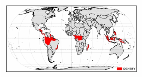
A) tropical monsoon.
B) tropical rainforest.
C) marine west coast.
D) hot low-latitude desert.
E) hot low-latitude steppe.
A) tropical monsoon.
B) tropical rainforest.
C) marine west coast.
D) hot low-latitude desert.
E) hot low-latitude steppe.
سؤال
سؤال
سؤال
سؤال
سؤال
سؤال
سؤال
سؤال
سؤال
سؤال
سؤال
سؤال
The climate of Mbandaka,Democratic Republic of the Congo shown below is 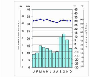
A) tropical savanna.
B) marine west-coast.
C) tropical monsoon.
D) hot low-latitude desert.
E) tropical rainforest.
A) tropical savanna.
B) marine west-coast.
C) tropical monsoon.
D) hot low-latitude desert.
E) tropical rainforest.
سؤال
سؤال
سؤال
سؤال
سؤال
سؤال
The climate shown on the map below is 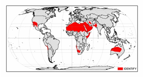
A) hot low-latitude desert.
B) tropical savanna.
C) cold midlatitude steppe.
D) hot low-latitude steppe.
E) tropical rainforest.
A) hot low-latitude desert.
B) tropical savanna.
C) cold midlatitude steppe.
D) hot low-latitude steppe.
E) tropical rainforest.
سؤال
The climate shown on the map below is 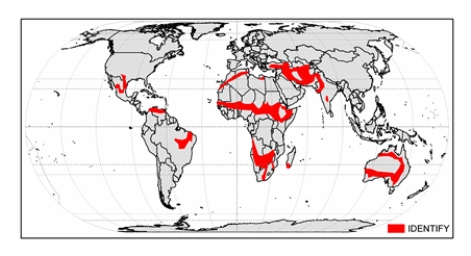
A) cold midlatitude steppe.
B) tropical savanna.
C) hot low-latitude desert.
D) cold midlatitude desert.
E) hot low-latitude steppe.
A) cold midlatitude steppe.
B) tropical savanna.
C) hot low-latitude desert.
D) cold midlatitude desert.
E) hot low-latitude steppe.
سؤال
The climate of Baghdad,Iraq,shown below,is 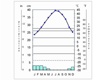
A) cold midlatitude steppe.
B) tropical savanna.
C) hot low-latitude desert.
D) cold midlatitude desert.
E) hot low-latitude steppe.
A) cold midlatitude steppe.
B) tropical savanna.
C) hot low-latitude desert.
D) cold midlatitude desert.
E) hot low-latitude steppe.
سؤال
The climate shown on the map below is 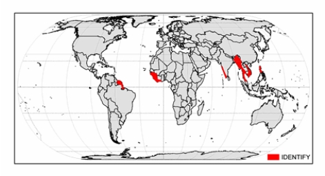
A) tropical savanna.
B) Mediterranean dry-summer.
C) marine west-coast.
D) tropical monsoon.
E) tropical rainforest.
A) tropical savanna.
B) Mediterranean dry-summer.
C) marine west-coast.
D) tropical monsoon.
E) tropical rainforest.
سؤال
سؤال
سؤال
سؤال
سؤال
سؤال
The climate of Manila,Philippines shown below is 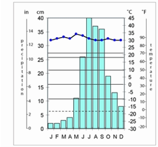
A) tropical monsoon.
B) Mediterranean dry-summer.
C) tropical rainforest.
D) marine west-coast.
E) tropical savanna.
A) tropical monsoon.
B) Mediterranean dry-summer.
C) tropical rainforest.
D) marine west-coast.
E) tropical savanna.
سؤال
سؤال
سؤال
سؤال
سؤال
سؤال
The climate of Darwin,Australia shown below is 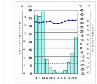
A) tropical monsoon.
B) tropical savanna.
C) hot low-latitude desert.
D) hot low-latitude steppe.
E) cold midlatitude steppe.
A) tropical monsoon.
B) tropical savanna.
C) hot low-latitude desert.
D) hot low-latitude steppe.
E) cold midlatitude steppe.
سؤال
The climograph of Cairo,Egypt shows 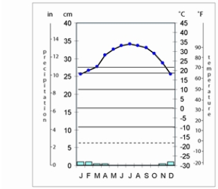
A) hot low-latitude desert.
B) cold midlatitude desert.
C) cold midlatitude steppe.
D) hot low-latitude steppe.
E) tropical savanna.
A) hot low-latitude desert.
B) cold midlatitude desert.
C) cold midlatitude steppe.
D) hot low-latitude steppe.
E) tropical savanna.
سؤال
The climate shown on the map below is 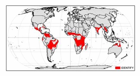
A) hot low-latitude desert.
B) hot low-latitude steppe.
C) tropical savanna.
D) tropical rainforest.
E) tropical monsoon.
A) hot low-latitude desert.
B) hot low-latitude steppe.
C) tropical savanna.
D) tropical rainforest.
E) tropical monsoon.
سؤال
Select the appropriate set of characteristics that describe each climate designation:
 Answer 1-7 Choices
humid with severe winter,no dry season,hot summer
humid with severe winter,no dry season,warm summer
humid with severe,dry winter,hot summer
humid with severe,dry winter,warm summer
severe,very cold and dry winter,cool summer
severe winter,no dry season,cool summer
severe,dry winter,cool summer
Answer 1-7 Choiceshumid with severe winter,no dry season,hot summer
humid with severe winter,no dry season,warm summer
humid with severe,dry winter,hot summer
humid with severe,dry winter,warm summer
severe,very cold and dry winter,cool summer
severe winter,no dry season,cool summer
severe,dry winter,cool summer
سؤال
The climate zone shown on the map below is 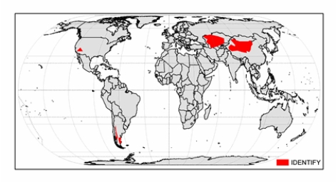
A) cold midlatitude steppe.
B) Mediterranean dry summer.
C) hot low-latitude desert.
D) cold midlatitude desert.
E) hot low-latitude steppe.
A) cold midlatitude steppe.
B) Mediterranean dry summer.
C) hot low-latitude desert.
D) cold midlatitude desert.
E) hot low-latitude steppe.
سؤال
The climograph of New Orleans,Louisiana,shown below,is 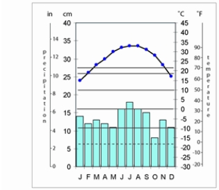
A) marine west coast.
B) humid subtropical hot-summer.
C) Mediterranean dry-summer.
D) humid continental hot-summer.
E) subarctic.
A) marine west coast.
B) humid subtropical hot-summer.
C) Mediterranean dry-summer.
D) humid continental hot-summer.
E) subarctic.
سؤال
The climate zone shown on the map below is 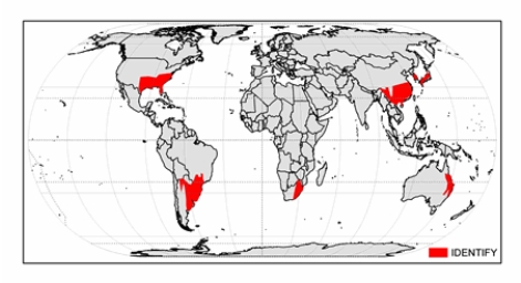
A) marine west coast.
B) humid subtropical hot-summer.
C) Mediterranean dry-summer.
D) humid continental hot-summer.
E) subarctic.
A) marine west coast.
B) humid subtropical hot-summer.
C) Mediterranean dry-summer.
D) humid continental hot-summer.
E) subarctic.
سؤال
سؤال
سؤال
سؤال
سؤال
سؤال
The climate of Denver,Colorado,shown below,is 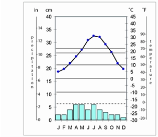
A) cold midlatitude desert.
B) Mediterranean dry summer.
C) hot low-latitude desert.
D) cold midlatitude steppe.
E) hot low-latitude steppe.
A) cold midlatitude desert.
B) Mediterranean dry summer.
C) hot low-latitude desert.
D) cold midlatitude steppe.
E) hot low-latitude steppe.
سؤال
سؤال
سؤال
سؤال
سؤال
The climograph of Yinchuan,China,shows 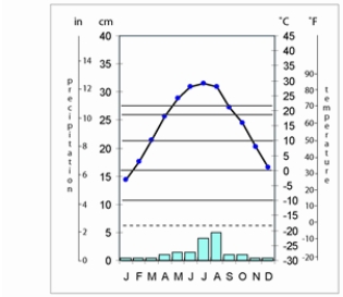
A) hot low-latitude desert.
B) hot low-latitude steppe.
C) cold midlatitude desert.
D) cold midlatitude steppe.
E) Mediterranean dry-summer.
A) hot low-latitude desert.
B) hot low-latitude steppe.
C) cold midlatitude desert.
D) cold midlatitude steppe.
E) Mediterranean dry-summer.
سؤال
سؤال
سؤال
The climate zone shown on the map below is 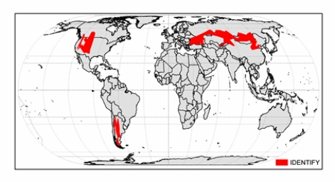
A) cold midlatitude steppe.
B) Mediterranean dry summer.
C) hot low-latitude desert.
D) cold midlatitude desert.
E) hot low-latitude steppe.
A) cold midlatitude steppe.
B) Mediterranean dry summer.
C) hot low-latitude desert.
D) cold midlatitude desert.
E) hot low-latitude steppe.
سؤال
سؤال
The climate zone shown on the map below is 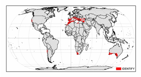
A) humid continental mild-summer.
B) humid subtropical hot-summer.
C) Mediterranean dry-summer.
D) humid continental hot-summer.
E) marine west-coast.
A) humid continental mild-summer.
B) humid subtropical hot-summer.
C) Mediterranean dry-summer.
D) humid continental hot-summer.
E) marine west-coast.
سؤال
سؤال
سؤال
سؤال
The climate of Seattle,Washington,shown below,is 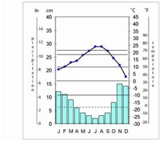
A) humid continental mild-summer.
B) humid subtropical hot-summer.
C) Mediterranean dry-summer.
D) humid continental hot-summer.
E) marine west-coast.
A) humid continental mild-summer.
B) humid subtropical hot-summer.
C) Mediterranean dry-summer.
D) humid continental hot-summer.
E) marine west-coast.
سؤال
سؤال
The climate zone shown on the map below is 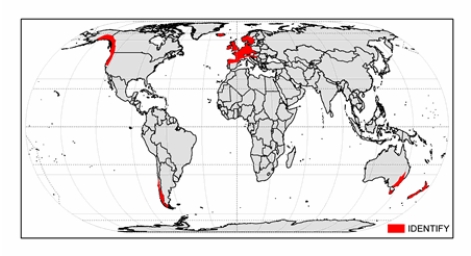
A) humid continental mild-summer.
B) humid subtropical hot-summer.
C) Mediterranean dry-summer.
D) humid continental hot-summer.
E) marine west-coast.
A) humid continental mild-summer.
B) humid subtropical hot-summer.
C) Mediterranean dry-summer.
D) humid continental hot-summer.
E) marine west-coast.
سؤال
The climate zone shown on the map below is 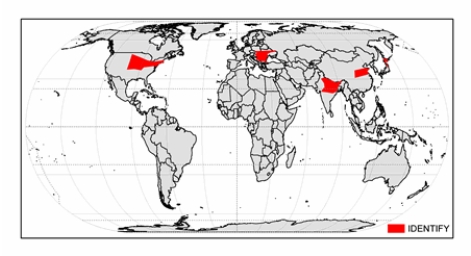
A) humid continental mild-summer.
B) subarctic.
C) humid continental hot-summer.
D) humid subtropical hot-summer.
E) marine west-coast.
A) humid continental mild-summer.
B) subarctic.
C) humid continental hot-summer.
D) humid subtropical hot-summer.
E) marine west-coast.
سؤال
The climate of Vladivostok,Russia,shown below,is 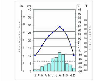
A) humid continental mild-summer.
B) subarctic.
C) humid continental hot-summer.
D) humid subtropical hot-summer.
E) marine west-coast.
A) humid continental mild-summer.
B) subarctic.
C) humid continental hot-summer.
D) humid subtropical hot-summer.
E) marine west-coast.
سؤال
سؤال
The climate of Seoul,South Korea,shown below,is 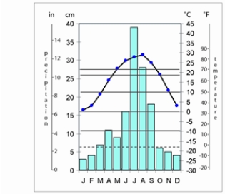
A) humid continental hot-summer.
B) humid continental mild-summer.
C) humid subtropical hot-summer.
D) subarctic.
E) marine west-coast.
A) humid continental hot-summer.
B) humid continental mild-summer.
C) humid subtropical hot-summer.
D) subarctic.
E) marine west-coast.
سؤال
سؤال
سؤال
سؤال
The climate of Minneapolis,Minnesota,shown below,is 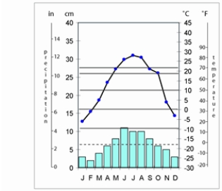
A) humid continental mild-summer.
B) subarctic.
C) humid continental hot-summer.
D) humid subtropical hot-summer.
E) marine west-coast.
A) humid continental mild-summer.
B) subarctic.
C) humid continental hot-summer.
D) humid subtropical hot-summer.
E) marine west-coast.
سؤال
سؤال
سؤال
The climate of Chicago,Illinois,shown below,is 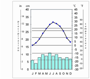
A) humid continental hot-summer.
B) humid continental mild-summer.
C) humid subtropical hot-summer.
D) subarctic.
E) marine west-coast.
A) humid continental hot-summer.
B) humid continental mild-summer.
C) humid subtropical hot-summer.
D) subarctic.
E) marine west-coast.
سؤال
سؤال
The climograph of Rome,Italy,shown below,is 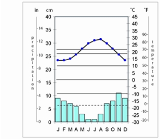
A) humid continental mild-summer.
B) humid subtropical hot-summer.
C) Mediterranean dry-summer.
D) humid continental hot-summer.
E) marine west-coast.
A) humid continental mild-summer.
B) humid subtropical hot-summer.
C) Mediterranean dry-summer.
D) humid continental hot-summer.
E) marine west-coast.
سؤال
The climate of Nome,Alaska,shown below,is 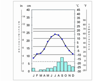
A) humid continental mild-summer.
B) subarctic.
C) cold midlatitude desert.
D) tundra.
E) ice cap.
A) humid continental mild-summer.
B) subarctic.
C) cold midlatitude desert.
D) tundra.
E) ice cap.
سؤال
The climate zone shown on the map is 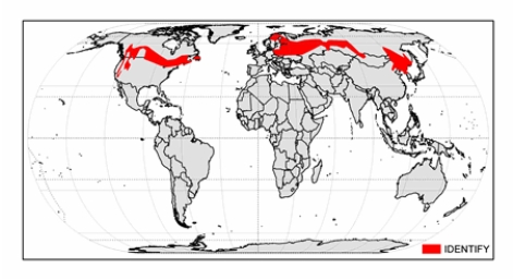
A) humid continental mild-summer.
B) subarctic.
C) humid continental hot-summer.
D) humid subtropical hot-summer.
E) tundra.
A) humid continental mild-summer.
B) subarctic.
C) humid continental hot-summer.
D) humid subtropical hot-summer.
E) tundra.
سؤال

فتح الحزمة
قم بالتسجيل لفتح البطاقات في هذه المجموعة!
Unlock Deck
Unlock Deck
1/176
العب
ملء الشاشة (f)
Deck 9: Global Climates and Global Climate Change
1
Overall,the most important climatic influence is:
a) latitude
b) seasonality
c) air mass circulation
d) maritime vs. continental relationships
e) topographic effects
a) latitude
b) seasonality
c) air mass circulation
d) maritime vs. continental relationships
e) topographic effects
latitude
2
Which of the following statements describes the climate of a particular place?
A) Winter is colder than summer.
B) Climate refers to the state of the atmosphere at a specific place at a particular time.
C) The barometer is rising.
D) It has been as cold here as -20°C.
A) Winter is colder than summer.
B) Climate refers to the state of the atmosphere at a specific place at a particular time.
C) The barometer is rising.
D) It has been as cold here as -20°C.
A,D
3
The climate zone shownon the map below is
A) tropical monsoon.
B) tropical rainforest.
C) marine west coast.
D) hot low-latitude desert.
E) hot low-latitude steppe.
A) tropical monsoon.
B) tropical rainforest.
C) marine west coast.
D) hot low-latitude desert.
E) hot low-latitude steppe.
B
4
The climate that has a greater daily temperature range than annual range is
A) marine west-coast.
B) humid subtropical hot-summer.
C) hot low-latitude desert.
D) tropical rainforest.
E) tropical savanna.
A) marine west-coast.
B) humid subtropical hot-summer.
C) hot low-latitude desert.
D) tropical rainforest.
E) tropical savanna.
فتح الحزمة
افتح القفل للوصول البطاقات البالغ عددها 176 في هذه المجموعة.
فتح الحزمة
k this deck
5
The climatic influence that moderates temperatures,influences air flows,and supplies water vapor is
A) latitude
B) seasonality
C) air mass circulation
D) maritime vs. continental relationships
E) topographic effects
A) latitude
B) seasonality
C) air mass circulation
D) maritime vs. continental relationships
E) topographic effects
فتح الحزمة
افتح القفل للوصول البطاقات البالغ عددها 176 في هذه المجموعة.
فتح الحزمة
k this deck
6
The climatic influence that controls the position of the ITCZ and subtropical high system is
A) latitude
B) seasonality
C) air mass circulation
D) maritime vs. continental relationships
E) topographic effects
A) latitude
B) seasonality
C) air mass circulation
D) maritime vs. continental relationships
E) topographic effects
فتح الحزمة
افتح القفل للوصول البطاقات البالغ عددها 176 في هذه المجموعة.
فتح الحزمة
k this deck
7
The study of short-term atmospheric phenomena is part of the field of
A) geology.
B) meteorology.
C) climatology.
D) dendrochronology.
E) astronomy.
A) geology.
B) meteorology.
C) climatology.
D) dendrochronology.
E) astronomy.
فتح الحزمة
افتح القفل للوصول البطاقات البالغ عددها 176 في هذه المجموعة.
فتح الحزمة
k this deck
8
The climate depicted by a climograph with nearly a straight line graph high on the chart and a bar graph with consistently long bars is
A) hot low-latitude desert.
B) marine west-coast.
C) tropical rainforest.
D) tropical savanna.
E) tropical monsoon.
A) hot low-latitude desert.
B) marine west-coast.
C) tropical rainforest.
D) tropical savanna.
E) tropical monsoon.
فتح الحزمة
افتح القفل للوصول البطاقات البالغ عددها 176 في هذه المجموعة.
فتح الحزمة
k this deck
9
The presence of the ITCZ means a tremendous amount of rainfall because of
A) frontal uplift.
B) orographic uplift.
C) convectional uplift.
D) convergent uplift.
E) extremely stable air.
A) frontal uplift.
B) orographic uplift.
C) convectional uplift.
D) convergent uplift.
E) extremely stable air.
فتح الحزمة
افتح القفل للوصول البطاقات البالغ عددها 176 في هذه المجموعة.
فتح الحزمة
k this deck
10
A rectangular graph that shows the mean monthly temperatures and total monthly precipitation is a(n)
A) analemma.
B) isotherm.
C) wind rose.
D) climatograph.
E) climograph.
A) analemma.
B) isotherm.
C) wind rose.
D) climatograph.
E) climograph.
فتح الحزمة
افتح القفل للوصول البطاقات البالغ عددها 176 في هذه المجموعة.
فتح الحزمة
k this deck
11
Which of the following describes climatology?
A) the daily weather elements
B) the study of the state of the atmosphere at a specific place at a particular time
C) the rising barometer
D) the study of the geographic distribution and character of the average weather elements and their extremes
E) the wind blowing at 20 mph
A) the daily weather elements
B) the study of the state of the atmosphere at a specific place at a particular time
C) the rising barometer
D) the study of the geographic distribution and character of the average weather elements and their extremes
E) the wind blowing at 20 mph
فتح الحزمة
افتح القفل للوصول البطاقات البالغ عددها 176 في هذه المجموعة.
فتح الحزمة
k this deck
12
Which of the following statements are true about the effects of latitude and longitude on weather and climate?
A) Latitude is the most important factor influencing climate.
B) Longitude directly affects the length of day.
C) Latitude affects radiation intensity and the length of day.
D) Longitude is the least significant factor affecting weather.
E) Latitude directly affects how cloudy it is on a particular day.
فتح الحزمة
افتح القفل للوصول البطاقات البالغ عددها 176 في هذه المجموعة.
فتح الحزمة
k this deck
13
The statement "It will be 87°F today" is an example of which term?
A) climate
B) weather
C) paleoclimate
D) seasonality
E) latitude
A) climate
B) weather
C) paleoclimate
D) seasonality
E) latitude
فتح الحزمة
افتح القفل للوصول البطاقات البالغ عددها 176 في هذه المجموعة.
فتح الحزمة
k this deck
14
The most widely used system of climate classification in the United States is by:
فتح الحزمة
افتح القفل للوصول البطاقات البالغ عددها 176 في هذه المجموعة.
فتح الحزمة
k this deck
15
The climate of Mbandaka,Democratic Republic of the Congo shown below is
A) tropical savanna.
B) marine west-coast.
C) tropical monsoon.
D) hot low-latitude desert.
E) tropical rainforest.
A) tropical savanna.
B) marine west-coast.
C) tropical monsoon.
D) hot low-latitude desert.
E) tropical rainforest.
فتح الحزمة
افتح القفل للوصول البطاقات البالغ عددها 176 في هذه المجموعة.
فتح الحزمة
k this deck
16
The difference between a tropical rainforest and tropical monsoon climate is that the tropical monsoon
A) is at least 5° cooler every month.
B) has a short dry season but a very wet rainy season.
C) is at least 300 m higher elevation.
D) has more vegetation, so it is warmer.
E) is excessively wet every month.
A) is at least 5° cooler every month.
B) has a short dry season but a very wet rainy season.
C) is at least 300 m higher elevation.
D) has more vegetation, so it is warmer.
E) is excessively wet every month.
فتح الحزمة
افتح القفل للوصول البطاقات البالغ عددها 176 في هذه المجموعة.
فتح الحزمة
k this deck
17
Select all of the statements below that apply to weather:
A) It is the state of the atmosphere at a specific place at a particular time.
B) "It might snow tonight" describes the weather.
C) "Winter is colder than summer" describes the weather.
D) It is concerned with the day-to-day changes in temperature and precipitation.
E) It is the average and extreme temperature and precipitation over a length of time
فتح الحزمة
افتح القفل للوصول البطاقات البالغ عددها 176 في هذه المجموعة.
فتح الحزمة
k this deck
18
The climatic effect that influences precipitation and air flow locally is
A) latitude
B) seasonality
C) air mass circulation
D) maritime vs. continental relationships
E) topographic effects
A) latitude
B) seasonality
C) air mass circulation
D) maritime vs. continental relationships
E) topographic effects
فتح الحزمة
افتح القفل للوصول البطاقات البالغ عددها 176 في هذه المجموعة.
فتح الحزمة
k this deck
19
The climate influence that is BEST associated with the intertropical convergence zone and midlatitude cyclones is:
A) latitude
B) seasonality
C) air mass circulation
D) maritime vs. continental relationships
E) topographic effects
A) latitude
B) seasonality
C) air mass circulation
D) maritime vs. continental relationships
E) topographic effects
فتح الحزمة
افتح القفل للوصول البطاقات البالغ عددها 176 في هذه المجموعة.
فتح الحزمة
k this deck
20
The climate BEST associated with the Amazon Basin,Indonesia,and Cameroon is
A) tropical monsoon.
B) hot low-latitude desert.
C) marine west-coast.
D) tropical rainforest.
E) hot low-latitude steppe.
A) tropical monsoon.
B) hot low-latitude desert.
C) marine west-coast.
D) tropical rainforest.
E) hot low-latitude steppe.
فتح الحزمة
افتح القفل للوصول البطاقات البالغ عددها 176 في هذه المجموعة.
فتح الحزمة
k this deck
21
The climate shown on the map below is
A) hot low-latitude desert.
B) tropical savanna.
C) cold midlatitude steppe.
D) hot low-latitude steppe.
E) tropical rainforest.
A) hot low-latitude desert.
B) tropical savanna.
C) cold midlatitude steppe.
D) hot low-latitude steppe.
E) tropical rainforest.
فتح الحزمة
افتح القفل للوصول البطاقات البالغ عددها 176 في هذه المجموعة.
فتح الحزمة
k this deck
22
The climate shown on the map below is
A) cold midlatitude steppe.
B) tropical savanna.
C) hot low-latitude desert.
D) cold midlatitude desert.
E) hot low-latitude steppe.
A) cold midlatitude steppe.
B) tropical savanna.
C) hot low-latitude desert.
D) cold midlatitude desert.
E) hot low-latitude steppe.
فتح الحزمة
افتح القفل للوصول البطاقات البالغ عددها 176 في هذه المجموعة.
فتح الحزمة
k this deck
23
The climate of Baghdad,Iraq,shown below,is
A) cold midlatitude steppe.
B) tropical savanna.
C) hot low-latitude desert.
D) cold midlatitude desert.
E) hot low-latitude steppe.
A) cold midlatitude steppe.
B) tropical savanna.
C) hot low-latitude desert.
D) cold midlatitude desert.
E) hot low-latitude steppe.
فتح الحزمة
افتح القفل للوصول البطاقات البالغ عددها 176 في هذه المجموعة.
فتح الحزمة
k this deck
24
The climate shown on the map below is
A) tropical savanna.
B) Mediterranean dry-summer.
C) marine west-coast.
D) tropical monsoon.
E) tropical rainforest.
A) tropical savanna.
B) Mediterranean dry-summer.
C) marine west-coast.
D) tropical monsoon.
E) tropical rainforest.
فتح الحزمة
افتح القفل للوصول البطاقات البالغ عددها 176 في هذه المجموعة.
فتح الحزمة
k this deck
25
The climate associated with much of northern Africa,Saudi Arabia,and the outback of central Australia is
A) hot low-latitude desert.
B) tropical savanna.
C) cold midlatitude steppe.
D) hot low-latitude steppe.
E) tropical rainforest.
A) hot low-latitude desert.
B) tropical savanna.
C) cold midlatitude steppe.
D) hot low-latitude steppe.
E) tropical rainforest.
فتح الحزمة
افتح القفل للوصول البطاقات البالغ عددها 176 في هذه المجموعة.
فتح الحزمة
k this deck
26
The climate at the west coast of India,coastal Myanmar (Burma),Suriname,and Liberia is
A) marine west-coast.
B) Mediterranean dry-summer.
C) tropical rainforest.
D) tropical savanna.
E) tropical monsoon.
A) marine west-coast.
B) Mediterranean dry-summer.
C) tropical rainforest.
D) tropical savanna.
E) tropical monsoon.
فتح الحزمة
افتح القفل للوصول البطاقات البالغ عددها 176 في هذه المجموعة.
فتح الحزمة
k this deck
27
The climate of Timbo,New Guinea is
A) marine west coast.
B) tropical savanna.
C) hot low-latitude desert.
D) tropical rainforest.
E) hot low-latitude steppe.
A) marine west coast.
B) tropical savanna.
C) hot low-latitude desert.
D) tropical rainforest.
E) hot low-latitude steppe.
فتح الحزمة
افتح القفل للوصول البطاقات البالغ عددها 176 في هذه المجموعة.
فتح الحزمة
k this deck
28
The climate that is found in eastern Peru,eastern Angola,western Thailand,Cuba,and northern Australia is
A) hot low-latitude desert.
B) hot low-latitude steppe.
C) tropical savanna.
D) tropical rainforest.
E) tropical monsoon.
A) hot low-latitude desert.
B) hot low-latitude steppe.
C) tropical savanna.
D) tropical rainforest.
E) tropical monsoon.
فتح الحزمة
افتح القفل للوصول البطاقات البالغ عددها 176 في هذه المجموعة.
فتح الحزمة
k this deck
29
A climograph that shows a high slightly curved line graph,some long bars,and some very short bars in winter is
A) hot low-latitude steppe.
B) hot low-latitude desert.
C) tropical rainforest.
D) tropical savanna.
E) tropical monsoon.
A) hot low-latitude steppe.
B) hot low-latitude desert.
C) tropical rainforest.
D) tropical savanna.
E) tropical monsoon.
فتح الحزمة
افتح القفل للوصول البطاقات البالغ عددها 176 في هذه المجموعة.
فتح الحزمة
k this deck
30
The climate of Manila,Philippines shown below is
A) tropical monsoon.
B) Mediterranean dry-summer.
C) tropical rainforest.
D) marine west-coast.
E) tropical savanna.
A) tropical monsoon.
B) Mediterranean dry-summer.
C) tropical rainforest.
D) marine west-coast.
E) tropical savanna.
فتح الحزمة
افتح القفل للوصول البطاقات البالغ عددها 176 في هذه المجموعة.
فتح الحزمة
k this deck
31
The climograph that shows a fairly flat curve high on the graphs and a few very short bars and some very long bars,perhaps off of the graph,is the
A) tropical savanna.
B) marine west-coast.
C) tropical rainforest.
D) tropical monsoon.
E) hot low-latitude steppe.
A) tropical savanna.
B) marine west-coast.
C) tropical rainforest.
D) tropical monsoon.
E) hot low-latitude steppe.
فتح الحزمة
افتح القفل للوصول البطاقات البالغ عددها 176 في هذه المجموعة.
فتح الحزمة
k this deck
32
The major climate group that is NOT based on temperature is
A) A.
B) B.
C) C.
D) D.
E) E.
A) A.
B) B.
C) C.
D) D.
E) E.
فتح الحزمة
افتح القفل للوصول البطاقات البالغ عددها 176 في هذه المجموعة.
فتح الحزمة
k this deck
33
A climograph with a gently arching curve consistently high on the chart and consistently very short or absent bars shows
A) hot low-latitude desert.
B) cold midlatitude desert.
C) cold midlatitude steppe.
D) hot low-latitude steppe.
E) tropical savanna.
A) hot low-latitude desert.
B) cold midlatitude desert.
C) cold midlatitude steppe.
D) hot low-latitude steppe.
E) tropical savanna.
فتح الحزمة
افتح القفل للوصول البطاقات البالغ عددها 176 في هذه المجموعة.
فتح الحزمة
k this deck
34
" B" climates are initially distinguished by
A) topography.
B) temperature.
C) soil type.
D) air mass.
E) moisture.
A) topography.
B) temperature.
C) soil type.
D) air mass.
E) moisture.
فتح الحزمة
افتح القفل للوصول البطاقات البالغ عددها 176 في هذه المجموعة.
فتح الحزمة
k this deck
35
A climograph with a curving arch high on the graph and short bars,very short bars,and even absent bars is
A) cold midlatitude steppe.
B) tropical savanna.
C) hot low-latitude desert.
D) cold midlatitude desert.
E) hot low-latitude steppe.
A) cold midlatitude steppe.
B) tropical savanna.
C) hot low-latitude desert.
D) cold midlatitude desert.
E) hot low-latitude steppe.
فتح الحزمة
افتح القفل للوصول البطاقات البالغ عددها 176 في هذه المجموعة.
فتح الحزمة
k this deck
36
The climate of Darwin,Australia shown below is
A) tropical monsoon.
B) tropical savanna.
C) hot low-latitude desert.
D) hot low-latitude steppe.
E) cold midlatitude steppe.
A) tropical monsoon.
B) tropical savanna.
C) hot low-latitude desert.
D) hot low-latitude steppe.
E) cold midlatitude steppe.
فتح الحزمة
افتح القفل للوصول البطاقات البالغ عددها 176 في هذه المجموعة.
فتح الحزمة
k this deck
37
The climograph of Cairo,Egypt shows
A) hot low-latitude desert.
B) cold midlatitude desert.
C) cold midlatitude steppe.
D) hot low-latitude steppe.
E) tropical savanna.
A) hot low-latitude desert.
B) cold midlatitude desert.
C) cold midlatitude steppe.
D) hot low-latitude steppe.
E) tropical savanna.
فتح الحزمة
افتح القفل للوصول البطاقات البالغ عددها 176 في هذه المجموعة.
فتح الحزمة
k this deck
38
The climate shown on the map below is
A) hot low-latitude desert.
B) hot low-latitude steppe.
C) tropical savanna.
D) tropical rainforest.
E) tropical monsoon.
A) hot low-latitude desert.
B) hot low-latitude steppe.
C) tropical savanna.
D) tropical rainforest.
E) tropical monsoon.
فتح الحزمة
افتح القفل للوصول البطاقات البالغ عددها 176 في هذه المجموعة.
فتح الحزمة
k this deck
39
Select the appropriate set of characteristics that describe each climate designation:
Answer 1-7 Choices
humid with severe winter,no dry season,hot summer
humid with severe winter,no dry season,warm summer
humid with severe,dry winter,hot summer
humid with severe,dry winter,warm summer
severe,very cold and dry winter,cool summer
severe winter,no dry season,cool summer
severe,dry winter,cool summer
Answer 1-7 Choiceshumid with severe winter,no dry season,hot summer
humid with severe winter,no dry season,warm summer
humid with severe,dry winter,hot summer
humid with severe,dry winter,warm summer
severe,very cold and dry winter,cool summer
severe winter,no dry season,cool summer
severe,dry winter,cool summer
فتح الحزمة
افتح القفل للوصول البطاقات البالغ عددها 176 في هذه المجموعة.
فتح الحزمة
k this deck
40
The climate zone shown on the map below is
A) cold midlatitude steppe.
B) Mediterranean dry summer.
C) hot low-latitude desert.
D) cold midlatitude desert.
E) hot low-latitude steppe.
A) cold midlatitude steppe.
B) Mediterranean dry summer.
C) hot low-latitude desert.
D) cold midlatitude desert.
E) hot low-latitude steppe.
فتح الحزمة
افتح القفل للوصول البطاقات البالغ عددها 176 في هذه المجموعة.
فتح الحزمة
k this deck
41
The climograph of New Orleans,Louisiana,shown below,is
A) marine west coast.
B) humid subtropical hot-summer.
C) Mediterranean dry-summer.
D) humid continental hot-summer.
E) subarctic.
A) marine west coast.
B) humid subtropical hot-summer.
C) Mediterranean dry-summer.
D) humid continental hot-summer.
E) subarctic.
فتح الحزمة
افتح القفل للوصول البطاقات البالغ عددها 176 في هذه المجموعة.
فتح الحزمة
k this deck
42
The climate zone shown on the map below is
A) marine west coast.
B) humid subtropical hot-summer.
C) Mediterranean dry-summer.
D) humid continental hot-summer.
E) subarctic.
A) marine west coast.
B) humid subtropical hot-summer.
C) Mediterranean dry-summer.
D) humid continental hot-summer.
E) subarctic.
فتح الحزمة
افتح القفل للوصول البطاقات البالغ عددها 176 في هذه المجموعة.
فتح الحزمة
k this deck
43
The climate in northern Arizona,south central Argentina,Mongolia,and northern Kazakhstan is
A) cold midlatitude steppe.
B) humid continental.
C) hot low-latitude desert.
D) cold midlatitude desert.
E) hot low-latitude steppe.
A) cold midlatitude steppe.
B) humid continental.
C) hot low-latitude desert.
D) cold midlatitude desert.
E) hot low-latitude steppe.
فتح الحزمة
افتح القفل للوصول البطاقات البالغ عددها 176 في هذه المجموعة.
فتح الحزمة
k this deck
44
Match the climate name with its correct Köppen designation(s): Subarctic
A) Dfb
B) Dwc
C) Dfa
D) Dfc
E) Dwb
F) Dwa
G) Dwd
A) Dfb
B) Dwc
C) Dfa
D) Dfc
E) Dwb
F) Dwa
G) Dwd
فتح الحزمة
افتح القفل للوصول البطاقات البالغ عددها 176 في هذه المجموعة.
فتح الحزمة
k this deck
45
A climograph with a midrange curve and predominantly very short or short bars is
A) hot low-latitude desert.
B) hot low-latitude steppe.
C) cold midlatitude desert.
D) cold midlatitude steppe
E) Mediterranean dry-sum.mer.
A) hot low-latitude desert.
B) hot low-latitude steppe.
C) cold midlatitude desert.
D) cold midlatitude steppe
E) Mediterranean dry-sum.mer.
فتح الحزمة
افتح القفل للوصول البطاقات البالغ عددها 176 في هذه المجموعة.
فتح الحزمة
k this deck
46
A climograph with a middle to a high-level curve and consistently short to very short bars shows
A) cold midlatitude steppe.
B) Mediterranean dry summer.
C) hot low-latitude desert.
D) cold midlatitude desert.
E) hot low-latitude steppe.
A) cold midlatitude steppe.
B) Mediterranean dry summer.
C) hot low-latitude desert.
D) cold midlatitude desert.
E) hot low-latitude steppe.
فتح الحزمة
افتح القفل للوصول البطاقات البالغ عددها 176 في هذه المجموعة.
فتح الحزمة
k this deck
47
The climate where most people live is
A) Tropical (A.)
B) Dry (B.)
C) Mesothermal (C.)
D) Microthermal (D.)
E) Polar (H.)
A) Tropical (A.)
B) Dry (B.)
C) Mesothermal (C.)
D) Microthermal (D.)
E) Polar (H.)
فتح الحزمة
افتح القفل للوصول البطاقات البالغ عددها 176 في هذه المجموعة.
فتح الحزمة
k this deck
48
The climate of Denver,Colorado,shown below,is
A) cold midlatitude desert.
B) Mediterranean dry summer.
C) hot low-latitude desert.
D) cold midlatitude steppe.
E) hot low-latitude steppe.
A) cold midlatitude desert.
B) Mediterranean dry summer.
C) hot low-latitude desert.
D) cold midlatitude steppe.
E) hot low-latitude steppe.
فتح الحزمة
افتح القفل للوصول البطاقات البالغ عددها 176 في هذه المجموعة.
فتح الحزمة
k this deck
49
Which of the following statements are true about the Atacama Desert?
A) It is the driest place on Earth.
B) Continentality and rain shadow are major factors responsible for the dry conditions.
C) STH and the ITCZ are major factors responsible for the dry conditions.
D) It is the second driest place on Earth, behind the Sahara Desert.
E) Cold ocean current and rain shadow are major factors responsible for the dry conditions.
F) Cold ocean current and STH are major factors responsible for the dry conditions
فتح الحزمة
افتح القفل للوصول البطاقات البالغ عددها 176 في هذه المجموعة.
فتح الحزمة
k this deck
50
Match the climate name with its correct Köppen designation(s): Humid Continental Hot-Summer
A) Dfb
B) Dwc
C) Dfa
D) Dfc
E) Dwb
F) Dwa
G) Dwd
A) Dfb
B) Dwc
C) Dfa
D) Dfc
E) Dwb
F) Dwa
G) Dwd
فتح الحزمة
افتح القفل للوصول البطاقات البالغ عددها 176 في هذه المجموعة.
فتح الحزمة
k this deck
51
Which of the following are types of D climates?
A) Humid Continental Hot-Summer
B) Subarctic
C) Humid Subtropical Hot-Summer
D) Humid Continental Mild-Summer
E) Humid Continental Cool-Summer
A) Humid Continental Hot-Summer
B) Subarctic
C) Humid Subtropical Hot-Summer
D) Humid Continental Mild-Summer
E) Humid Continental Cool-Summer
فتح الحزمة
افتح القفل للوصول البطاقات البالغ عددها 176 في هذه المجموعة.
فتح الحزمة
k this deck
52
The climate found in the southeast United States,southeast China,northeast Queensland,Australia,Lesotho,and Uruguay is
A) marine west coast.
B) humid subtropical hot-summer.
C) Mediterranean dry-summer.
D) humid continental hot-summer.
E) subarctic.
A) marine west coast.
B) humid subtropical hot-summer.
C) Mediterranean dry-summer.
D) humid continental hot-summer.
E) subarctic.
فتح الحزمة
افتح القفل للوصول البطاقات البالغ عددها 176 في هذه المجموعة.
فتح الحزمة
k this deck
53
The climograph of Yinchuan,China,shows
A) hot low-latitude desert.
B) hot low-latitude steppe.
C) cold midlatitude desert.
D) cold midlatitude steppe.
E) Mediterranean dry-summer.
A) hot low-latitude desert.
B) hot low-latitude steppe.
C) cold midlatitude desert.
D) cold midlatitude steppe.
E) Mediterranean dry-summer.
فتح الحزمة
افتح القفل للوصول البطاقات البالغ عددها 176 في هذه المجموعة.
فتح الحزمة
k this deck
54
Match the climate name with its correct Köppen designation(s): Humid Continental Mild-Summer
A) Dfb
B) Dwc
C) Dfa
D) Dfc
E) Dwb
F) Dwa
G) Dwd
A) Dfb
B) Dwc
C) Dfa
D) Dfc
E) Dwb
F) Dwa
G) Dwd
فتح الحزمة
افتح القفل للوصول البطاقات البالغ عددها 176 في هذه المجموعة.
فتح الحزمة
k this deck
55
The climate found in southern Kazakhstan,north central China,and Patagonia in Argentina is
A) cold midlatitude steppe.
B) Mediterranean dry summer.
C) hot low-latitude desert.
D) cold midlatitude desert.
E) hot low-latitude steppe.
A) cold midlatitude steppe.
B) Mediterranean dry summer.
C) hot low-latitude desert.
D) cold midlatitude desert.
E) hot low-latitude steppe.
فتح الحزمة
افتح القفل للوصول البطاقات البالغ عددها 176 في هذه المجموعة.
فتح الحزمة
k this deck
56
The climate zone shown on the map below is
A) cold midlatitude steppe.
B) Mediterranean dry summer.
C) hot low-latitude desert.
D) cold midlatitude desert.
E) hot low-latitude steppe.
A) cold midlatitude steppe.
B) Mediterranean dry summer.
C) hot low-latitude desert.
D) cold midlatitude desert.
E) hot low-latitude steppe.
فتح الحزمة
افتح القفل للوصول البطاقات البالغ عددها 176 في هذه المجموعة.
فتح الحزمة
k this deck
57
The climate in Botswana,coastal Iran,central Queensland in Australia,and Tamaulipas in Mexico is
A) cold midlatitude steppe.
B) tropical savanna.
C) hot low-latitude desert.
D) cold midlatitude desert.
E) hot low-latitude steppe.
A) cold midlatitude steppe.
B) tropical savanna.
C) hot low-latitude desert.
D) cold midlatitude desert.
E) hot low-latitude steppe.
فتح الحزمة
افتح القفل للوصول البطاقات البالغ عددها 176 في هذه المجموعة.
فتح الحزمة
k this deck
58
The climate zone shown on the map below is
A) humid continental mild-summer.
B) humid subtropical hot-summer.
C) Mediterranean dry-summer.
D) humid continental hot-summer.
E) marine west-coast.
A) humid continental mild-summer.
B) humid subtropical hot-summer.
C) Mediterranean dry-summer.
D) humid continental hot-summer.
E) marine west-coast.
فتح الحزمة
افتح القفل للوصول البطاقات البالغ عددها 176 في هذه المجموعة.
فتح الحزمة
k this deck
59
A climograph showing a moderated midrange curve above freezing with a crest matched with short bars and the trough matched with medium bars is
A) humid continental mild-summer.
B) humid subtropical hot-summer.
C) Mediterranean dry-summer.
D) humid continental hot-summer
E) marine west-coast
A) humid continental mild-summer.
B) humid subtropical hot-summer.
C) Mediterranean dry-summer.
D) humid continental hot-summer
E) marine west-coast
فتح الحزمة
افتح القفل للوصول البطاقات البالغ عددها 176 في هذه المجموعة.
فتح الحزمة
k this deck
60
The climate of western Washington and Oregon,Europe,Tasmania,and New Zealand is
A) humid continental mild-summer.
B) humid subtropical hot-summer.
C) Mediterranean dry-summer.
D) humid continental hot-summer.
E) marine west-coast.
A) humid continental mild-summer.
B) humid subtropical hot-summer.
C) Mediterranean dry-summer.
D) humid continental hot-summer.
E) marine west-coast.
فتح الحزمة
افتح القفل للوصول البطاقات البالغ عددها 176 في هذه المجموعة.
فتح الحزمة
k this deck
61
Which of the following only have monthly mean temperatures above freezing?
A) ice cap
B) tundra
C) humid continental hot-summer
D) humid subtropical hot-summer
E) subarctic
A) ice cap
B) tundra
C) humid continental hot-summer
D) humid subtropical hot-summer
E) subarctic
فتح الحزمة
افتح القفل للوصول البطاقات البالغ عددها 176 في هذه المجموعة.
فتح الحزمة
k this deck
62
The climate of Seattle,Washington,shown below,is
A) humid continental mild-summer.
B) humid subtropical hot-summer.
C) Mediterranean dry-summer.
D) humid continental hot-summer.
E) marine west-coast.
A) humid continental mild-summer.
B) humid subtropical hot-summer.
C) Mediterranean dry-summer.
D) humid continental hot-summer.
E) marine west-coast.
فتح الحزمة
افتح القفل للوصول البطاقات البالغ عددها 176 في هذه المجموعة.
فتح الحزمة
k this deck
63
The climate associated with Spain,Italy,Greece,Southern California,Cape Town,South Africa,and the southwestern tip of Australia is
A) humid continental mild-summer.
B) humid subtropical hot-summer.
C) Mediterranean dry-summer.
D) humid continental hot-summer.
E) marine west-coast.
A) humid continental mild-summer.
B) humid subtropical hot-summer.
C) Mediterranean dry-summer.
D) humid continental hot-summer.
E) marine west-coast.
فتح الحزمة
افتح القفل للوصول البطاقات البالغ عددها 176 في هذه المجموعة.
فتح الحزمة
k this deck
64
The climate zone shown on the map below is
A) humid continental mild-summer.
B) humid subtropical hot-summer.
C) Mediterranean dry-summer.
D) humid continental hot-summer.
E) marine west-coast.
A) humid continental mild-summer.
B) humid subtropical hot-summer.
C) Mediterranean dry-summer.
D) humid continental hot-summer.
E) marine west-coast.
فتح الحزمة
افتح القفل للوصول البطاقات البالغ عددها 176 في هذه المجموعة.
فتح الحزمة
k this deck
65
The climate zone shown on the map below is
A) humid continental mild-summer.
B) subarctic.
C) humid continental hot-summer.
D) humid subtropical hot-summer.
E) marine west-coast.
A) humid continental mild-summer.
B) subarctic.
C) humid continental hot-summer.
D) humid subtropical hot-summer.
E) marine west-coast.
فتح الحزمة
افتح القفل للوصول البطاقات البالغ عددها 176 في هذه المجموعة.
فتح الحزمة
k this deck
66
The climate of Vladivostok,Russia,shown below,is
A) humid continental mild-summer.
B) subarctic.
C) humid continental hot-summer.
D) humid subtropical hot-summer.
E) marine west-coast.
A) humid continental mild-summer.
B) subarctic.
C) humid continental hot-summer.
D) humid subtropical hot-summer.
E) marine west-coast.
فتح الحزمة
افتح القفل للوصول البطاقات البالغ عددها 176 في هذه المجموعة.
فتح الحزمة
k this deck
67
The climate most noted for the summer drought and winter precipitation is
A) humid continental mild-summer.
B) humid subtropical hot-summer.
C) Mediterranean dry-summer.
D) humid continental hot-summer.
E) marine west-coast.
A) humid continental mild-summer.
B) humid subtropical hot-summer.
C) Mediterranean dry-summer.
D) humid continental hot-summer.
E) marine west-coast.
فتح الحزمة
افتح القفل للوصول البطاقات البالغ عددها 176 في هذه المجموعة.
فتح الحزمة
k this deck
68
The climate of Seoul,South Korea,shown below,is
A) humid continental hot-summer.
B) humid continental mild-summer.
C) humid subtropical hot-summer.
D) subarctic.
E) marine west-coast.
A) humid continental hot-summer.
B) humid continental mild-summer.
C) humid subtropical hot-summer.
D) subarctic.
E) marine west-coast.
فتح الحزمة
افتح القفل للوصول البطاقات البالغ عددها 176 في هذه المجموعة.
فتح الحزمة
k this deck
69
A climograph with a long,steep curve with the trough well below freezing and short or medium bars is
A) humid continental.
B) subarctic.
C) ice cap.
D) humid subtropical.
E) marine west-coast.
A) humid continental.
B) subarctic.
C) ice cap.
D) humid subtropical.
E) marine west-coast.
فتح الحزمة
افتح القفل للوصول البطاقات البالغ عددها 176 في هذه المجموعة.
فتح الحزمة
k this deck
70
Which one of the following climates has monthly average temperatures above freezing?
A) H
B) B
C) C
D) D
E) E
A) H
B) B
C) C
D) D
E) E
فتح الحزمة
افتح القفل للوصول البطاقات البالغ عددها 176 في هذه المجموعة.
فتح الحزمة
k this deck
71
A climograph with a distinct curve remaining above freezing and at least 100 cm (40 in.)of precipitation total so that it has a dominance of mid-length bars is
A) marine west coast.
B) humid subtropical hot-summer.
C) Mediterranean dry-summer.
D) humid continental hot-summer.
E) subarctic.
A) marine west coast.
B) humid subtropical hot-summer.
C) Mediterranean dry-summer.
D) humid continental hot-summer.
E) subarctic.
فتح الحزمة
افتح القفل للوصول البطاقات البالغ عددها 176 في هذه المجموعة.
فتح الحزمة
k this deck
72
The climate of Minneapolis,Minnesota,shown below,is
A) humid continental mild-summer.
B) subarctic.
C) humid continental hot-summer.
D) humid subtropical hot-summer.
E) marine west-coast.
A) humid continental mild-summer.
B) subarctic.
C) humid continental hot-summer.
D) humid subtropical hot-summer.
E) marine west-coast.
فتح الحزمة
افتح القفل للوصول البطاقات البالغ عددها 176 في هذه المجموعة.
فتح الحزمة
k this deck
73
The climate that shows a somewhat flattened curve above freezing with possibly a few short bars but also some long bars is
A) humid continental mild-summer.
B) humid subtropical hot-summer.
C) Mediterranean dry-summer.
D) humid continental hot-summer.
E) marine west-coast.
A) humid continental mild-summer.
B) humid subtropical hot-summer.
C) Mediterranean dry-summer.
D) humid continental hot-summer.
E) marine west-coast.
فتح الحزمة
افتح القفل للوصول البطاقات البالغ عددها 176 في هذه المجموعة.
فتح الحزمة
k this deck
74
The climate found almost exclusively in the Northern Hemisphere is
A) A.
B) B.
C) C.
D) D.
E) E.
A) A.
B) B.
C) C.
D) D.
E) E.
فتح الحزمة
افتح القفل للوصول البطاقات البالغ عددها 176 في هذه المجموعة.
فتح الحزمة
k this deck
75
The climate of Chicago,Illinois,shown below,is
A) humid continental hot-summer.
B) humid continental mild-summer.
C) humid subtropical hot-summer.
D) subarctic.
E) marine west-coast.
A) humid continental hot-summer.
B) humid continental mild-summer.
C) humid subtropical hot-summer.
D) subarctic.
E) marine west-coast.
فتح الحزمة
افتح القفل للوصول البطاقات البالغ عددها 176 في هذه المجموعة.
فتح الحزمة
k this deck
76
The climate in North Korea,southern Michigan,Iowa,and northern Ohio and Indiana is
A) humid continental mild-summer.
B) subarctic.
C) humid continental hot-summer.
D) humid subtropical hot-summer.
E) marine west-coast.
A) humid continental mild-summer.
B) subarctic.
C) humid continental hot-summer.
D) humid subtropical hot-summer.
E) marine west-coast.
فتح الحزمة
افتح القفل للوصول البطاقات البالغ عددها 176 في هذه المجموعة.
فتح الحزمة
k this deck
77
The climograph of Rome,Italy,shown below,is
A) humid continental mild-summer.
B) humid subtropical hot-summer.
C) Mediterranean dry-summer.
D) humid continental hot-summer.
E) marine west-coast.
A) humid continental mild-summer.
B) humid subtropical hot-summer.
C) Mediterranean dry-summer.
D) humid continental hot-summer.
E) marine west-coast.
فتح الحزمة
افتح القفل للوصول البطاقات البالغ عددها 176 في هذه المجموعة.
فتح الحزمة
k this deck
78
The climate of Nome,Alaska,shown below,is
A) humid continental mild-summer.
B) subarctic.
C) cold midlatitude desert.
D) tundra.
E) ice cap.
A) humid continental mild-summer.
B) subarctic.
C) cold midlatitude desert.
D) tundra.
E) ice cap.
فتح الحزمة
افتح القفل للوصول البطاقات البالغ عددها 176 في هذه المجموعة.
فتح الحزمة
k this deck
79
The climate zone shown on the map is
A) humid continental mild-summer.
B) subarctic.
C) humid continental hot-summer.
D) humid subtropical hot-summer.
E) tundra.
A) humid continental mild-summer.
B) subarctic.
C) humid continental hot-summer.
D) humid subtropical hot-summer.
E) tundra.
فتح الحزمة
افتح القفل للوصول البطاقات البالغ عددها 176 في هذه المجموعة.
فتح الحزمة
k this deck
80
Select the characteristics that are associated with subarctic climates.
A) no true summer
B) long winters and short summers
C) bitterly cold winter
D) mild winters
E) cool summers
F) greatest annual range in temperature
A) no true summer
B) long winters and short summers
C) bitterly cold winter
D) mild winters
E) cool summers
F) greatest annual range in temperature
فتح الحزمة
افتح القفل للوصول البطاقات البالغ عددها 176 في هذه المجموعة.
فتح الحزمة
k this deck
فتح الحزمة
افتح القفل للوصول البطاقات البالغ عددها 176 في هذه المجموعة.


