Deck 10: Crustal Deformation and Mountain Building
ملء الشاشة (f)
سؤال
سؤال
سؤال
سؤال
سؤال
سؤال
سؤال
سؤال
سؤال
سؤال
سؤال
سؤال
سؤال
سؤال
سؤال
سؤال
سؤال
سؤال
سؤال
سؤال
سؤال
سؤال
سؤال
Use this figure for the following questions: 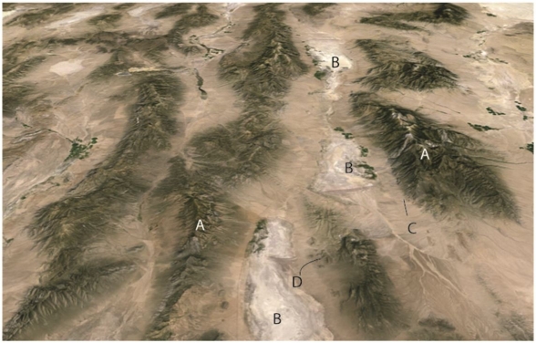 The figure above is an oblique Google earth image from southwestern North America looking approximately north.The view is approximately 50km across.The area is a classic area of normal faulting.
The area labeled C shows an active fault bounding the range.Which best describes the motion on the fault?
A)west side up
B)east side up
C)north side down
D)south side down
E)right lateral strike-slip
The figure above is an oblique Google earth image from southwestern North America looking approximately north.The view is approximately 50km across.The area is a classic area of normal faulting.The area labeled C shows an active fault bounding the range.Which best describes the motion on the fault?
A)west side up
B)east side up
C)north side down
D)south side down
E)right lateral strike-slip
سؤال
سؤال
سؤال
سؤال
سؤال
سؤال
سؤال
Use this figure for the following questions: The figure above is an oblique Google earth image from southwestern North America looking approximately north.The view is approximately 50km across.The area is a classic area of normal faulting.
This area represents what type of mountain system
A)Fault block mountains
B)Andrean type mountains
C)Collisional orogen
D)Strike-slip mountains
The figure above is an oblique Google earth image from southwestern North America looking approximately north.The view is approximately 50km across.The area is a classic area of normal faulting.This area represents what type of mountain system
A)Fault block mountains
B)Andrean type mountains
C)Collisional orogen
D)Strike-slip mountains
سؤال
سؤال
سؤال
سؤال
سؤال
سؤال
سؤال
سؤال
سؤال
سؤال
سؤال
سؤال
سؤال
سؤال
سؤال
سؤال
سؤال
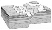
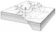
Refer to the figure below,captured from Google Earth,for the following questions. 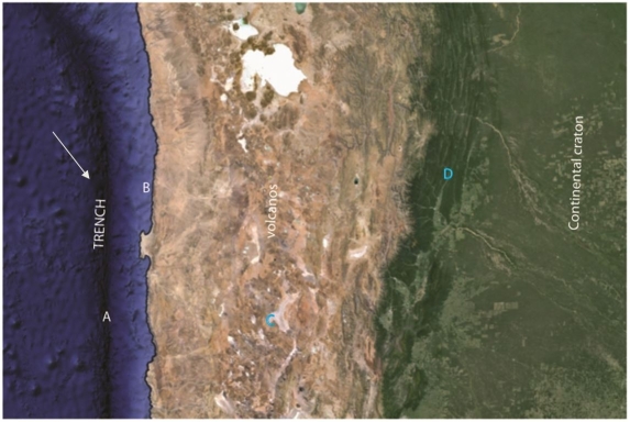
This mountain belt would be called ________.
A)a collisional mountain belt
B)a terrane accretion mountain belt
C)an Andrean mountain belt
D)fault block mountains
This mountain belt would be called ________.
A)a collisional mountain belt
B)a terrane accretion mountain belt
C)an Andrean mountain belt
D)fault block mountains
سؤال
سؤال
سؤال
سؤال
سؤال
سؤال
سؤال
سؤال
سؤال
سؤال
سؤال
سؤال
سؤال
سؤال
سؤال
________ 
سؤال
سؤال
سؤال
سؤال
سؤال
Use this figure for the following questions:  The figure above is an oblique Google earth image from southwestern North America looking approximately north.The view is approximately 50km across.The area is a classic area of normal faulting.
The topographic highlands,or ranges,in this area labeled A are also called ________ blocks.
The figure above is an oblique Google earth image from southwestern North America looking approximately north.The view is approximately 50km across.The area is a classic area of normal faulting.The topographic highlands,or ranges,in this area labeled A are also called ________ blocks.
سؤال
________ 
سؤال
What type of structure is shown below? 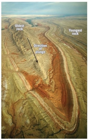
سؤال
سؤال
Use this figure for the following questions: The figure above is an oblique Google earth image from southwestern North America looking approximately north.The view is approximately 50km across.The area is a classic area of normal faulting.
Topographic basins like the areas labeled B in this figure are called ________.
The figure above is an oblique Google earth image from southwestern North America looking approximately north.The view is approximately 50km across.The area is a classic area of normal faulting.Topographic basins like the areas labeled B in this figure are called ________.
سؤال
Use this figure for the following questions: 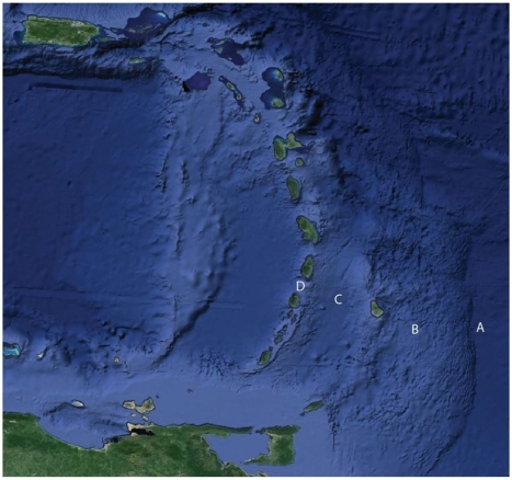 The figure above shows a popular area for North American tourists in winter,the Caribbean region.Match the term to the letter on the Figure.
Island arc
The figure above shows a popular area for North American tourists in winter,the Caribbean region.Match the term to the letter on the Figure.Island arc
سؤال
________ 
سؤال
On the blanks provided below,fill in the name of the specific type of geologic features that have been labeled. 
سؤال
سؤال
سؤال
Use this figure for the following questions: The figure above shows a popular area for North American tourists in winter,the Caribbean region.Match the term to the letter on the Figure.
Accretionary Wedge
The figure above shows a popular area for North American tourists in winter,the Caribbean region.Match the term to the letter on the Figure.Accretionary Wedge
سؤال
Use this figure for the following questions: The figure above shows a popular area for North American tourists in winter,the Caribbean region.Match the term to the letter on the Figure.
Forearc Basin
The figure above shows a popular area for North American tourists in winter,the Caribbean region.Match the term to the letter on the Figure.Forearc Basin
سؤال
سؤال

فتح الحزمة
قم بالتسجيل لفتح البطاقات في هذه المجموعة!
Unlock Deck
Unlock Deck
1/97
العب
ملء الشاشة (f)
Deck 10: Crustal Deformation and Mountain Building
1
A(n)________ fault has little or no vertical movements of the two blocks.
A)stick slip
B)oblique slip
C)strike slip
D)dip slip
A)stick slip
B)oblique slip
C)strike slip
D)dip slip
C
2
The San Andreas Fault in California and the Alpine Fault in New Zealand are examples of ________.
A)normal faults
B)thrust faults
C)strike-slip faults
D)oblique-slip normal faults
A)normal faults
B)thrust faults
C)strike-slip faults
D)oblique-slip normal faults
C
3
In the figure,which of the deformations appears most similar to what might be expected along a divergent plate boundary?
A)original
B)X
C)Y
D)Z
A)original
B)X
C)Y
D)Z
C
4
In the figure,which of the deformations appears most similar to what might be expected along a transform plate boundary?
A)original
B)X
C)Y
D)Z
A)original
B)X
C)Y
D)Z
فتح الحزمة
افتح القفل للوصول البطاقات البالغ عددها 97 في هذه المجموعة.
فتح الحزمة
k this deck
5
You are walking north across dipping beds in sedimentary rocks.You walk across 200m of rocks with a relatively constant dip of 20 degrees to the south.Suddenly you come to beds with lower dip that become flat lying,and then dip north across a horizontal distance of only about 30m.As you walk on the beds become more steeply dipping until they dip almost 80 degrees to the north.You walk across these steeply dipping beds for 40m,and then beds return to a south dip of about 20 degrees.What kind of structure(s)did you just walk across? (A sketch may help you solve this problem.)
A)a symmetric anticline
B)an asymmetric syncline
C)an asymmetric anticline and syncline
D)an asymmetric anticline
E)a symmetric syncline
A)a symmetric anticline
B)an asymmetric syncline
C)an asymmetric anticline and syncline
D)an asymmetric anticline
E)a symmetric syncline
فتح الحزمة
افتح القفل للوصول البطاقات البالغ عددها 97 في هذه المجموعة.
فتح الحزمة
k this deck
6
In the figure,the stress on block 'X' is ________.
A)shear
B)folding
C)tensional
D)compressional
A)shear
B)folding
C)tensional
D)compressional
فتح الحزمة
افتح القفل للوصول البطاقات البالغ عددها 97 في هذه المجموعة.
فتح الحزمة
k this deck
7
A transform fault is ________.
A)a strike-slip fault that forms the boundary between tectonic plates
B)a dip-slip fault connecting an anticline with a syncline
C)a reverse fault that steepens into a thrust fault
D)the rift bounding fault on a mid-ocean ridge
A)a strike-slip fault that forms the boundary between tectonic plates
B)a dip-slip fault connecting an anticline with a syncline
C)a reverse fault that steepens into a thrust fault
D)the rift bounding fault on a mid-ocean ridge
فتح الحزمة
افتح القفل للوصول البطاقات البالغ عددها 97 في هذه المجموعة.
فتح الحزمة
k this deck
8
The material in the figure was ________ when the folding occurred.
A)ductile
B)elastic
C)brittle
D)strong
A)ductile
B)elastic
C)brittle
D)strong
فتح الحزمة
افتح القفل للوصول البطاقات البالغ عددها 97 في هذه المجموعة.
فتح الحزمة
k this deck
9
The concepts of "stress" and "strain" are related because ________.
A)"strain" causes "stress"
B)"stress" causes "strain"
C)compressional "stress" causes a convergent plate boundary to form
D)compressional "strain" causes a convergent plate boundary to form
A)"strain" causes "stress"
B)"stress" causes "strain"
C)compressional "stress" causes a convergent plate boundary to form
D)compressional "strain" causes a convergent plate boundary to form
فتح الحزمة
افتح القفل للوصول البطاقات البالغ عددها 97 في هذه المجموعة.
فتح الحزمة
k this deck
10
In the figure,the stress on block 'Y' is ________.
A)shear
B)folding
C)tensional
D)compressional
A)shear
B)folding
C)tensional
D)compressional
فتح الحزمة
افتح القفل للوصول البطاقات البالغ عددها 97 في هذه المجموعة.
فتح الحزمة
k this deck
11
Folds are an example of ________.
A)brittle deformation
B)ductile deformation
C)elastic deformation
D)shear deformation
A)brittle deformation
B)ductile deformation
C)elastic deformation
D)shear deformation
فتح الحزمة
افتح القفل للوصول البطاقات البالغ عددها 97 في هذه المجموعة.
فتح الحزمة
k this deck
12
Large circular downwarped structures are called ________.
A)anticlines
B)synclines
C)basins
D)domes
A)anticlines
B)synclines
C)basins
D)domes
فتح الحزمة
افتح القفل للوصول البطاقات البالغ عددها 97 في هذه المجموعة.
فتح الحزمة
k this deck
13
Most active faults pose a risk to society because they can potentially produce ________.
A)landslides
B)tsunamis
C)earthquakes
D)disruptions in groundwater flow
A)landslides
B)tsunamis
C)earthquakes
D)disruptions in groundwater flow
فتح الحزمة
افتح القفل للوصول البطاقات البالغ عددها 97 في هذه المجموعة.
فتح الحزمة
k this deck
14
Monoclines,anticlines,synclines and domes are all examples of ________.
A)faulting
B)jointing
C)flow
D)foliation
A)faulting
B)jointing
C)flow
D)foliation
فتح الحزمة
افتح القفل للوصول البطاقات البالغ عددها 97 في هذه المجموعة.
فتح الحزمة
k this deck
15
In the figure,the stress on block 'Z' is ________.
A)shear
B)folding
C)tensional
D)compressional
A)shear
B)folding
C)tensional
D)compressional
فتح الحزمة
افتح القفل للوصول البطاقات البالغ عددها 97 في هذه المجموعة.
فتح الحزمة
k this deck
16
Burial of rocks increases the confining pressure so that deeply buried rocks are more likely to ________ than shallow rocks.
A)fracture
B)fold
C)deform
D)shear
A)fracture
B)fold
C)deform
D)shear
فتح الحزمة
افتح القفل للوصول البطاقات البالغ عددها 97 في هذه المجموعة.
فتح الحزمة
k this deck
17
In a monocline,one of the limbs of the fold ________.
A)is horizontal
B)is vertical
C)dips in the same direction as the other limb,but at a lower angle
D)has a shallower dip in the opposite direction of the other limb
A)is horizontal
B)is vertical
C)dips in the same direction as the other limb,but at a lower angle
D)has a shallower dip in the opposite direction of the other limb
فتح الحزمة
افتح القفل للوصول البطاقات البالغ عددها 97 في هذه المجموعة.
فتح الحزمة
k this deck
18
The higher the temperature,the more likely it is that a rock will deform ________.
A)ductilely
B)brittlely
C)elastically
D)shearingly
A)ductilely
B)brittlely
C)elastically
D)shearingly
فتح الحزمة
افتح القفل للوصول البطاقات البالغ عددها 97 في هذه المجموعة.
فتح الحزمة
k this deck
19
When subjected to a differential stress,a very "brittle" material,like glass,will ________.
A)not bend at all.It will only break.
B)deform by breaking or elastic bending
C)flow or shear if the stress is large enough
D)flow under low to moderate stress conditions
A)not bend at all.It will only break.
B)deform by breaking or elastic bending
C)flow or shear if the stress is large enough
D)flow under low to moderate stress conditions
فتح الحزمة
افتح القفل للوصول البطاقات البالغ عددها 97 في هذه المجموعة.
فتح الحزمة
k this deck
20
In an overturned fold,the beds have rotated ________.
A)more than 180 degrees
B)more than 90 degrees
C)more than 45 degrees
D)100 to 150 degrees
A)more than 180 degrees
B)more than 90 degrees
C)more than 45 degrees
D)100 to 150 degrees
فتح الحزمة
افتح القفل للوصول البطاقات البالغ عددها 97 في هذه المجموعة.
فتح الحزمة
k this deck
21
Grabens are formed by what type of faulting?
A)normal
B)reverse
C)strike-slip
D)collision
A)normal
B)reverse
C)strike-slip
D)collision
فتح الحزمة
افتح القفل للوصول البطاقات البالغ عددها 97 في هذه المجموعة.
فتح الحزمة
k this deck
22
You are walking on the beach along the south-coast of Alaska.You see rocks cut by numerous faults that consist of basalt with evidence of eruption in the ocean,deep-water chert,mudstone,and sandstones with abundant volcanic material.What tectonic setting would you assign to these rocks?
A)passive continental margin sequence
B)forearc basin
C)continental interior basin
D)accretionary wedge
A)passive continental margin sequence
B)forearc basin
C)continental interior basin
D)accretionary wedge
فتح الحزمة
افتح القفل للوصول البطاقات البالغ عددها 97 في هذه المجموعة.
فتح الحزمة
k this deck
23
Use this figure for the following questions: The figure above is an oblique Google earth image from southwestern North America looking approximately north.The view is approximately 50km across.The area is a classic area of normal faulting.
The area labeled C shows an active fault bounding the range.Which best describes the motion on the fault?
A)west side up
B)east side up
C)north side down
D)south side down
E)right lateral strike-slip
The figure above is an oblique Google earth image from southwestern North America looking approximately north.The view is approximately 50km across.The area is a classic area of normal faulting.The area labeled C shows an active fault bounding the range.Which best describes the motion on the fault?
A)west side up
B)east side up
C)north side down
D)south side down
E)right lateral strike-slip
فتح الحزمة
افتح القفل للوصول البطاقات البالغ عددها 97 في هذه المجموعة.
فتح الحزمة
k this deck
24
In a(n)________ fault,the hanging wall block moves up with respect to the footwall block.
A)normal
B)strike slip
C)reverse
D)abnormal
A)normal
B)strike slip
C)reverse
D)abnormal
فتح الحزمة
افتح القفل للوصول البطاقات البالغ عددها 97 في هذه المجموعة.
فتح الحزمة
k this deck
25
Most granitic batholiths represent ________.
A)a deeply exhumed passive continental margin
B)a deeply exhumed forearc rock assemblage
C)magmas generated in a rift system,prior to development of a passive margin
D)the exhumed roots of a subduction related magmatic arc
A)a deeply exhumed passive continental margin
B)a deeply exhumed forearc rock assemblage
C)magmas generated in a rift system,prior to development of a passive margin
D)the exhumed roots of a subduction related magmatic arc
فتح الحزمة
افتح القفل للوصول البطاقات البالغ عددها 97 في هذه المجموعة.
فتح الحزمة
k this deck
26
A good example of a present-day,passive continental margin is the ________.
A)north flank of the East Pacific Rise
B)west coast of South America
C)east coast of the Japanese Islands
D)east coast of North America
A)north flank of the East Pacific Rise
B)west coast of South America
C)east coast of the Japanese Islands
D)east coast of North America
فتح الحزمة
افتح القفل للوصول البطاقات البالغ عددها 97 في هذه المجموعة.
فتح الحزمة
k this deck
27
In thrust faulting,________.
A)grabens develop on the footwall block
B)the crust is shortened and thickened
C)horizontal,tensional stresses drive the deformation
D)the hanging wall block slips downward along the thrust fault
A)grabens develop on the footwall block
B)the crust is shortened and thickened
C)horizontal,tensional stresses drive the deformation
D)the hanging wall block slips downward along the thrust fault
فتح الحزمة
افتح القفل للوصول البطاقات البالغ عددها 97 في هذه المجموعة.
فتح الحزمة
k this deck
28
Granitic batholiths typically form over time intervals of ________.
A)tens of thousands of years
B)hundreds of thousands of years
C)millions of years
D)billions of years
A)tens of thousands of years
B)hundreds of thousands of years
C)millions of years
D)billions of years
فتح الحزمة
افتح القفل للوصول البطاقات البالغ عددها 97 في هذه المجموعة.
فتح الحزمة
k this deck
29
The Peninsular terrane is now part of the crust of North America in southern Alaska.The dominant rock type in this terrane is intrusive igneous rock that ranges in composition from gabbro to granite and volcanic rock with a similar compositional range.Geologic evidence indicates the Peninsular terrane collided with North America during late Mesozoic time.Which of the following would be the most reasonable interpretation for the origins of the Peninsular terrane?
A)a Mesozoic island arc
B)a Mesozoic oceanic plateau
C)a Mesozoic accretionary wedge
D)a Cenozoic forearc basin
E)a Paleozoic accretionary wedge
A)a Mesozoic island arc
B)a Mesozoic oceanic plateau
C)a Mesozoic accretionary wedge
D)a Cenozoic forearc basin
E)a Paleozoic accretionary wedge
فتح الحزمة
افتح القفل للوصول البطاقات البالغ عددها 97 في هذه المجموعة.
فتح الحزمة
k this deck
30
Use this figure for the following questions: The figure above is an oblique Google earth image from southwestern North America looking approximately north.The view is approximately 50km across.The area is a classic area of normal faulting.
This area represents what type of mountain system
A)Fault block mountains
B)Andrean type mountains
C)Collisional orogen
D)Strike-slip mountains
The figure above is an oblique Google earth image from southwestern North America looking approximately north.The view is approximately 50km across.The area is a classic area of normal faulting.This area represents what type of mountain system
A)Fault block mountains
B)Andrean type mountains
C)Collisional orogen
D)Strike-slip mountains
فتح الحزمة
افتح القفل للوصول البطاقات البالغ عددها 97 في هذه المجموعة.
فتح الحزمة
k this deck
31
Southwestern North America contains a large area called the Basin and Range province.What is the origin of this name?
A)Ranges are uplifted horst blocks adjacent to basins formed as graben.
B)The area is characterized by chains of volcanos forming ranges next to basins that form valleys.
C)Thrust faulting along the San Andreas fault produces linear ridges,the ranges,with intervening basinal valleys forming fault block mountains.
D)Folds have formed by compressional stresses along the plate margin forming ridges (ranges)and valleys (the basins)of the basin and range province.
فتح الحزمة
افتح القفل للوصول البطاقات البالغ عددها 97 في هذه المجموعة.
فتح الحزمة
k this deck
32
What type of basin would be most likely to contain large amounts of sediments derived from a volcanic source?
A)a continental interior basin
B)a passive continental margin
C)a forearc basin
D)a strike-slip basin
A)a continental interior basin
B)a passive continental margin
C)a forearc basin
D)a strike-slip basin
فتح الحزمة
افتح القفل للوصول البطاقات البالغ عددها 97 في هذه المجموعة.
فتح الحزمة
k this deck
33
A(n)________ is a thick accumulation of sediments and small tectonic blocks formed of material scraped off subducting oceanic lithosphere at a convergent margin.
A)mass movement complex
B)continental shelf,terrain complex
C)accretionary-wedge complex
D)subterranean-accumulation complex
A)mass movement complex
B)continental shelf,terrain complex
C)accretionary-wedge complex
D)subterranean-accumulation complex
فتح الحزمة
افتح القفل للوصول البطاقات البالغ عددها 97 في هذه المجموعة.
فتح الحزمة
k this deck
34
Studies of the chemistry of rocks from arc volcanos indicate the main source of the magma is ________.
A)melting of subducted oceanic crust
B)melting of the subducted mantle lithosphere
C)melting of the asthenosphere above the subducting oceanic plate by frictional heating on the subduction interface
D)melting of the asthenosphere above the subducting oceanic plate by fluids acting as a flux to enhance melting
فتح الحزمة
افتح القفل للوصول البطاقات البالغ عددها 97 في هذه المجموعة.
فتح الحزمة
k this deck
35
What is the modern theory for orogenesis?
A)geosynclinal theory
B)shrinking earth model
C)expanding earth theory
D)plate tectonics theory
A)geosynclinal theory
B)shrinking earth model
C)expanding earth theory
D)plate tectonics theory
فتح الحزمة
افتح القفل للوصول البطاقات البالغ عددها 97 في هذه المجموعة.
فتح الحزمة
k this deck
36
In what part of a subduction margin might you find rocks deposited on the abyssal plain,far from land?
A)Accretionary Wedge
B)Volcanic Arc
C)Forearc Basin
D)Cratonic Basin
A)Accretionary Wedge
B)Volcanic Arc
C)Forearc Basin
D)Cratonic Basin
فتح الحزمة
افتح القفل للوصول البطاقات البالغ عددها 97 في هذه المجموعة.
فتح الحزمة
k this deck
37
Island arcs and Andean type mountains are both examples of mountains formed by ________.
A)collisional tectonics
B)subduction
C)rifting/oceanic spreading
D)transform faults
A)collisional tectonics
B)subduction
C)rifting/oceanic spreading
D)transform faults
فتح الحزمة
افتح القفل للوصول البطاقات البالغ عددها 97 في هذه المجموعة.
فتح الحزمة
k this deck
38
The west coast of California is underlain by rocks that represent ________.
A)an ancient volcanic arc
B)an ancient Forearc Basin and accretionary wedge
C)a collisional orogenic belt
D)an oceanic plateau
A)an ancient volcanic arc
B)an ancient Forearc Basin and accretionary wedge
C)a collisional orogenic belt
D)an oceanic plateau
فتح الحزمة
افتح القفل للوصول البطاقات البالغ عددها 97 في هذه المجموعة.
فتح الحزمة
k this deck
39
The Sierra Nevada Mountains of California,and the Teton Mountains of Wyoming,ranges are examples of ________.
A)fault blocks uplifted by late Tertiary to Quaternary normal faulting
B)folding,compression,and thickening of Paleozoic strata in Jurassic time
C)isostatic uplift of crust over thickened in early Paleozoic time
D)uplifted blocks bounded by Quaternary reverse faults
A)fault blocks uplifted by late Tertiary to Quaternary normal faulting
B)folding,compression,and thickening of Paleozoic strata in Jurassic time
C)isostatic uplift of crust over thickened in early Paleozoic time
D)uplifted blocks bounded by Quaternary reverse faults
فتح الحزمة
افتح القفل للوصول البطاقات البالغ عددها 97 في هذه المجموعة.
فتح الحزمة
k this deck
40
Mountain building uplifts rocks against the force of gravity raising their potential energy,which requires work by the earth system.Based on the relative motion of fault blocks,what type of fault would you expect to require more energy than the others?
A)normal
B)strike-slip
C)thrust
D)There is no way of knowing.
A)normal
B)strike-slip
C)thrust
D)There is no way of knowing.
فتح الحزمة
افتح القفل للوصول البطاقات البالغ عددها 97 في هذه المجموعة.
فتح الحزمة
k this deck
41
The Rocky Mountains of western North America were produced in an orogeny called the ________.
A)Absaroka orogeny
B)Laurentide orogeny
C)Uinta orogeny
D)Laramide orogeny
A)Absaroka orogeny
B)Laurentide orogeny
C)Uinta orogeny
D)Laramide orogeny
فتح الحزمة
افتح القفل للوصول البطاقات البالغ عددها 97 في هذه المجموعة.
فتح الحزمة
k this deck
42
Island arc systems now on the Tibet plateau record subduction prior to the collision of India with Eurasia.Geologists would map these pre-collisional arc rocks as ________.
A)hot spot tracks
B)terranes
C)rift zones
D)pre-collisional transform zones
A)hot spot tracks
B)terranes
C)rift zones
D)pre-collisional transform zones
فتح الحزمة
افتح القفل للوصول البطاقات البالغ عددها 97 في هذه المجموعة.
فتح الحزمة
k this deck
43
When the differential stress exceeds the strength of the material,the material will begin to undergo elastic strain.
فتح الحزمة
افتح القفل للوصول البطاقات البالغ عددها 97 في هذه المجموعة.
فتح الحزمة
k this deck
44
In the interior of continents the earth's crust is typically about 40km thick and the elevation is near sea level.In an area where the crust is 20km thick,isostasy would suggest the elevation in this area would be ________ unless the density changes from one area to the other.
A)below sea level
B)near sea level
C)slightly above sea level
D)high mountains
A)below sea level
B)near sea level
C)slightly above sea level
D)high mountains
فتح الحزمة
افتح القفل للوصول البطاقات البالغ عددها 97 في هذه المجموعة.
فتح الحزمة
k this deck
45
The ________ is (are)characterized by terrane accretion that has been active throughout most of Mesozoic and Cenozoic time.
A)western margin of Africa
B)southern margins of India and Australia
C)western margin of North America
D)western margin of the Mid-Atlantic Ridge
A)western margin of Africa
B)southern margins of India and Australia
C)western margin of North America
D)western margin of the Mid-Atlantic Ridge
فتح الحزمة
افتح القفل للوصول البطاقات البالغ عددها 97 في هذه المجموعة.
فتح الحزمة
k this deck
46
Ocean spreading centers are highlands on the ocean floor,sometimes referred to as submarine mountains.Oceanic crust worldwide is about the same thickness so isostasy would suggest the ocean floor should be as flat as Kansas.Which of the following statements best describes the origin of these submarine mountains?
A)The ridges are sites of young volcanos that produce high topography on the sea floor,like Hawaii.
B)The ridges represent upwelling zones from the core which produces a bulge at the earth's surface.
C)Compression at the ridges produce local uplift along the ridge axis.
D)The mantle beneath the ridges remains hot for millions of years producing an elevated region along the ridge axis because hot rocks are lower density than cold rocks.
فتح الحزمة
افتح القفل للوصول البطاقات البالغ عددها 97 في هذه المجموعة.
فتح الحزمة
k this deck
47
Refer to the figure below,captured from Google Earth,for the following questions.
This mountain belt would be called ________.
A)a collisional mountain belt
B)a terrane accretion mountain belt
C)an Andrean mountain belt
D)fault block mountains
This mountain belt would be called ________.
A)a collisional mountain belt
B)a terrane accretion mountain belt
C)an Andrean mountain belt
D)fault block mountains
فتح الحزمة
افتح القفل للوصول البطاقات البالغ عددها 97 في هذه المجموعة.
فتح الحزمة
k this deck
48
Folded limestones that are exposed high elevations in the Himalayas were originally deposited as sediments in a ________.
A)marine basin between India and Eurasia.
B)Cenozoic fault basin between Africa and Arabia.
C)deep ocean trench along the southern margin of India.
D)late Paleozoic syncline north of the Tibetan Plateau.
A)marine basin between India and Eurasia.
B)Cenozoic fault basin between Africa and Arabia.
C)deep ocean trench along the southern margin of India.
D)late Paleozoic syncline north of the Tibetan Plateau.
فتح الحزمة
افتح القفل للوصول البطاقات البالغ عددها 97 في هذه المجموعة.
فتح الحزمة
k this deck
49
A widely cited theory associates active faults and earthquakes in China and southeast Asia to the India-Eurasia collision.This theory suggests ________.
A)East Asia is moving toward the Himalaya,causing faulting and earthquakes
B)subduction beneath East Asia is pushing East Asia toward the Himalaya,forming young mountains between the Himalaya and Pacific subduction zones
C)India is moving west relative to Eurasia,pulling central Asia away from East Asia
D)India is plowing into the "soft underbelly" of Asia,pushing East Asia eastward
فتح الحزمة
افتح القفل للوصول البطاقات البالغ عددها 97 في هذه المجموعة.
فتح الحزمة
k this deck
50
The Appalachian Mountains may have once been as lofty as the Himalayan-Tibetan Mountain belt is today.Why are they not this high now?
A)They developed a dense crustal root following collision,and isostasy forced them to sink to their present elevation.
B)They formed long ago,and erosion has beveled them to their present low elevation.
C)The mountains cooled following the collision,which increased the density of the of the rocks by cooling,and isostasy forced the mountains to sink.
D)Opening of the North Atlantic Ocean converted lithosphere to asthenosphere beneath eastern North America,forcing eastern North America to sink to low elevations.
فتح الحزمة
افتح القفل للوصول البطاقات البالغ عددها 97 في هذه المجموعة.
فتح الحزمة
k this deck
51
A thrust fault increases the thickness of the crust as it moves toward a continental interior in a mountain belt; yet the crust beyond the mountain front stays the same thickness.Isostasy would suggest that the area at the mountain front,where the thrust emerges,should ________ over time.
A)uplift
B)stay the same
C)subside
D)near sea level
A)uplift
B)stay the same
C)subside
D)near sea level
فتح الحزمة
افتح القفل للوصول البطاقات البالغ عددها 97 في هذه المجموعة.
فتح الحزمة
k this deck
52
In the interior of continents the earth's crust is typically about 40km thick and the elevation is near sea level.Most earth materials expand when heated,lowering their density.During rifting continental margins are heated but cool as sea floor spreading moves offshore from the continent.Thus,basic isostasy suggests that after rifting,a continental margin will ________.
A)uplift
B)subside
C)remain near sea level
D)rise slowly as erosion removes uplifted rocks
A)uplift
B)subside
C)remain near sea level
D)rise slowly as erosion removes uplifted rocks
فتح الحزمة
افتح القفل للوصول البطاقات البالغ عددها 97 في هذه المجموعة.
فتح الحزمة
k this deck
53
The Appalachians were formed by three phases of ________ orogeny.
A)collisional
B)Andean
C)rifting
D)transform
A)collisional
B)Andean
C)rifting
D)transform
فتح الحزمة
افتح القفل للوصول البطاقات البالغ عددها 97 في هذه المجموعة.
فتح الحزمة
k this deck
54
Orogenesis refers to the formation of mineral deposits.
فتح الحزمة
افتح القفل للوصول البطاقات البالغ عددها 97 في هذه المجموعة.
فتح الحزمة
k this deck
55
The Tibetan plateau is high above sea level because ________.
A)there are many active faults across Tibet that produce internal crustal thickening and uplift
B)the extrusion of East Asia has produced structures that thicken the crust under Tibet,producing regional uplift
C)a giant fault beneath Tibet raises it up relative to adjacent areas
D)crustal thickening over millions of years has produced a thick crust that stands high due to Isostasy
فتح الحزمة
افتح القفل للوصول البطاقات البالغ عددها 97 في هذه المجموعة.
فتح الحزمة
k this deck
56
The Himalayas and Tibet are the archetypical example of a(n)________ mountain belt.
A)Andean
B)continental rift
C)transform
D)collisional
A)Andean
B)continental rift
C)transform
D)collisional
فتح الحزمة
افتح القفل للوصول البطاقات البالغ عددها 97 في هذه المجموعة.
فتح الحزمة
k this deck
57
Most geologists think the elevation of mountains above sea level is limited by earth's gravity because ________.
A)rocks can never reach escape velocity
B)rock cliffs are subject to gravity failure and can only be about 1km high
C)the earth's mantle is too weak to support the load of large mountains
D)thickening of the crust in mountain belts produces a weak deep crust the spreads by gravity collapse,limiting the elevation
فتح الحزمة
افتح القفل للوصول البطاقات البالغ عددها 97 في هذه المجموعة.
فتح الحزمة
k this deck
58
Mountain building in the western margin of North America records a history of both ________.
A)continental collision and terrane accretion
B)Andean type subduction and terrane accretion
C)Andean type subduction and continental collision
D)none of the above
A)continental collision and terrane accretion
B)Andean type subduction and terrane accretion
C)Andean type subduction and continental collision
D)none of the above
فتح الحزمة
افتح القفل للوصول البطاقات البالغ عددها 97 في هذه المجموعة.
فتح الحزمة
k this deck
59
The hinge of a fold must lie within the axial plane of the fold.
فتح الحزمة
افتح القفل للوصول البطاقات البالغ عددها 97 في هذه المجموعة.
فتح الحزمة
k this deck
60
The boundary between two terranes or two continents that have collided is called a ________.
A)suture
B)join
C)weld
D)stitch
A)suture
B)join
C)weld
D)stitch
فتح الحزمة
افتح القفل للوصول البطاقات البالغ عددها 97 في هذه المجموعة.
فتح الحزمة
k this deck
61
Fractures in rock with no conspicuous offset are called ________.
فتح الحزمة
افتح القفل للوصول البطاقات البالغ عددها 97 في هذه المجموعة.
فتح الحزمة
k this deck
62
________
فتح الحزمة
افتح القفل للوصول البطاقات البالغ عددها 97 في هذه المجموعة.
فتح الحزمة
k this deck
63
Exhumed basins contain ________ rocks in the center of the structure and domes contain ________ rocks in the center.
فتح الحزمة
افتح القفل للوصول البطاقات البالغ عددها 97 في هذه المجموعة.
فتح الحزمة
k this deck
64
Changes in the shape of a rock body in response to a differential stress is called ________.
فتح الحزمة
افتح القفل للوصول البطاقات البالغ عددها 97 في هذه المجموعة.
فتح الحزمة
k this deck
65
A(n)________ fault forms when the hanging wall moves down relative to the footwall .
فتح الحزمة
افتح القفل للوصول البطاقات البالغ عددها 97 في هذه المجموعة.
فتح الحزمة
k this deck
66
Terrane accretion generally occurs along a divergent boundary between a continental plate and an oceanic plate.
فتح الحزمة
افتح القفل للوصول البطاقات البالغ عددها 97 في هذه المجموعة.
فتح الحزمة
k this deck
67
Use this figure for the following questions: The figure above is an oblique Google earth image from southwestern North America looking approximately north.The view is approximately 50km across.The area is a classic area of normal faulting.
The topographic highlands,or ranges,in this area labeled A are also called ________ blocks.
The figure above is an oblique Google earth image from southwestern North America looking approximately north.The view is approximately 50km across.The area is a classic area of normal faulting.The topographic highlands,or ranges,in this area labeled A are also called ________ blocks.
فتح الحزمة
افتح القفل للوصول البطاقات البالغ عددها 97 في هذه المجموعة.
فتح الحزمة
k this deck
68
________
فتح الحزمة
افتح القفل للوصول البطاقات البالغ عددها 97 في هذه المجموعة.
فتح الحزمة
k this deck
69
What type of structure is shown below?
فتح الحزمة
افتح القفل للوصول البطاقات البالغ عددها 97 في هذه المجموعة.
فتح الحزمة
k this deck
70
When the hinge line of a fold is not horizontal the fold is said to ________.
فتح الحزمة
افتح القفل للوصول البطاقات البالغ عددها 97 في هذه المجموعة.
فتح الحزمة
k this deck
71
Use this figure for the following questions: The figure above is an oblique Google earth image from southwestern North America looking approximately north.The view is approximately 50km across.The area is a classic area of normal faulting.
Topographic basins like the areas labeled B in this figure are called ________.
The figure above is an oblique Google earth image from southwestern North America looking approximately north.The view is approximately 50km across.The area is a classic area of normal faulting.Topographic basins like the areas labeled B in this figure are called ________.
فتح الحزمة
افتح القفل للوصول البطاقات البالغ عددها 97 في هذه المجموعة.
فتح الحزمة
k this deck
72
Use this figure for the following questions: The figure above shows a popular area for North American tourists in winter,the Caribbean region.Match the term to the letter on the Figure.
Island arc
The figure above shows a popular area for North American tourists in winter,the Caribbean region.Match the term to the letter on the Figure.Island arc
فتح الحزمة
افتح القفل للوصول البطاقات البالغ عددها 97 في هذه المجموعة.
فتح الحزمة
k this deck
73
________
فتح الحزمة
افتح القفل للوصول البطاقات البالغ عددها 97 في هذه المجموعة.
فتح الحزمة
k this deck
74
On the blanks provided below,fill in the name of the specific type of geologic features that have been labeled.
فتح الحزمة
افتح القفل للوصول البطاقات البالغ عددها 97 في هذه المجموعة.
فتح الحزمة
k this deck
75
Subduction only occurs when oceanic rocks are forced beneath a continent.
فتح الحزمة
افتح القفل للوصول البطاقات البالغ عددها 97 في هذه المجموعة.
فتح الحزمة
k this deck
76
Which letter in the figure above corresponds to a "syncline"?
فتح الحزمة
افتح القفل للوصول البطاقات البالغ عددها 97 في هذه المجموعة.
فتح الحزمة
k this deck
77
Use this figure for the following questions: The figure above shows a popular area for North American tourists in winter,the Caribbean region.Match the term to the letter on the Figure.
Accretionary Wedge
The figure above shows a popular area for North American tourists in winter,the Caribbean region.Match the term to the letter on the Figure.Accretionary Wedge
فتح الحزمة
افتح القفل للوصول البطاقات البالغ عددها 97 في هذه المجموعة.
فتح الحزمة
k this deck
78
Use this figure for the following questions: The figure above shows a popular area for North American tourists in winter,the Caribbean region.Match the term to the letter on the Figure.
Forearc Basin
The figure above shows a popular area for North American tourists in winter,the Caribbean region.Match the term to the letter on the Figure.Forearc Basin
فتح الحزمة
افتح القفل للوصول البطاقات البالغ عددها 97 في هذه المجموعة.
فتح الحزمة
k this deck
79
Which letter in the figure corresponds to a "fault"?
فتح الحزمة
افتح القفل للوصول البطاقات البالغ عددها 97 في هذه المجموعة.
فتح الحزمة
k this deck
80
Subduction produces mountains because subduction zones are the upwelling zones of mantle convection,which lifts the earth's surface to form mountains.
فتح الحزمة
افتح القفل للوصول البطاقات البالغ عددها 97 في هذه المجموعة.
فتح الحزمة
k this deck
فتح الحزمة
افتح القفل للوصول البطاقات البالغ عددها 97 في هذه المجموعة.


