Deck 10: Plate Tectonics and Regional Features
ملء الشاشة (f)
سؤال
In this figure of Japan,the offshore trenches indicate 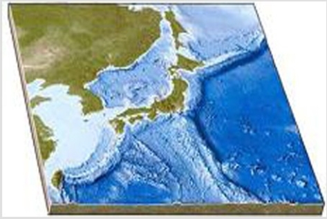
A)continental rifting.
B)a rift in a midocean ridge formed by seafloor spreading.
C)a rift in a midocean ridge formed by transform faulting.
D)subduction of oceanic crust.
A)continental rifting.
B)a rift in a midocean ridge formed by seafloor spreading.
C)a rift in a midocean ridge formed by transform faulting.
D)subduction of oceanic crust.
سؤال
On this map,identify the letter that is over a midocean ridge. 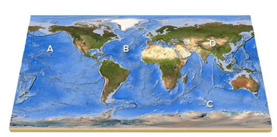
A)A
B)B
C)C
D)D
E)Feature is not labeled.
A)A
B)B
C)C
D)D
E)Feature is not labeled.
سؤال
On this map,identify the letter that is over an island arc. 
A)A
B)B
C)C
D)D
E)Feature is not labeled.
A)A
B)B
C)C
D)D
E)Feature is not labeled.
سؤال
سؤال
Which of the layers in the diagram below are rigid? 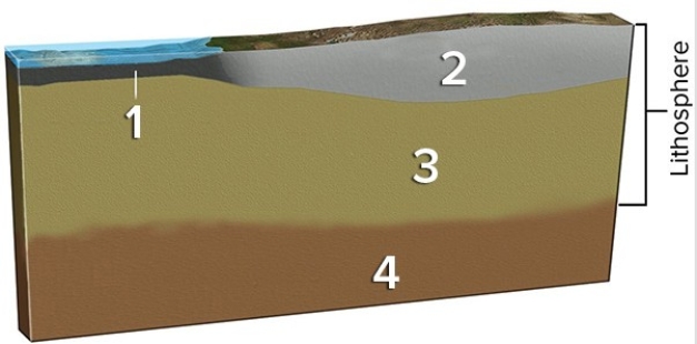
A)1 and 2
B)2 and 3
C)1,2,and 3
D)All of them are correct.
A)1 and 2
B)2 and 3
C)1,2,and 3
D)All of them are correct.
سؤال
On this map,identify the letter that is over the Atlantic Ocean. 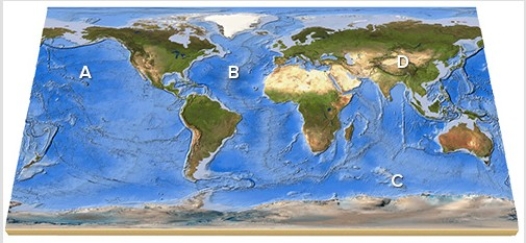
A)A
B)B
C)C
D)D
E)Feature is not labeled.
A)A
B)B
C)C
D)D
E)Feature is not labeled.
سؤال
On this southern continent,which side has a plate boundary? 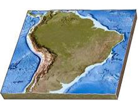
A)The left (west)side
B)The right (east)side
C)Both sides
D)Neither side
A)The left (west)side
B)The right (east)side
C)Both sides
D)Neither side
سؤال
How did the Red Sea,shown between Arabia and Africa in this figure,form? 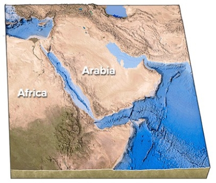
A)Subduction of Arabia beneath Africa
B)Subduction of Africa beneath Arabia
C)A continental collision
D)Continental rifting followed by seafloor spreading
E)Transform faulting followed by a continental collision
A)Subduction of Arabia beneath Africa
B)Subduction of Africa beneath Arabia
C)A continental collision
D)Continental rifting followed by seafloor spreading
E)Transform faulting followed by a continental collision
سؤال
In the diagram below,which layer(s)correspond to the mantle? 
A)1 and 2
B)3
C)3 and 4
D)4
A)1 and 2
B)3
C)3 and 4
D)4
سؤال
سؤال
Which of the following features is present on the seafloor off the Pacific Northwest? 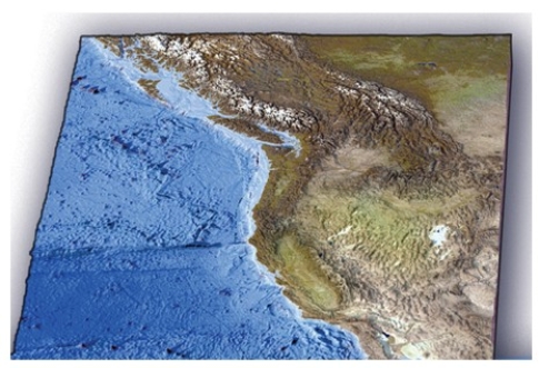
A)World's largest oceanic plateau
B)Long,fairly straight fracture zone
C)World's largest linear island chain
D)Island arc within oceanic plates
A)World's largest oceanic plateau
B)Long,fairly straight fracture zone
C)World's largest linear island chain
D)Island arc within oceanic plates
سؤال
On this map of the south Atlantic,what is the feature that makes a zigzag pattern on the seafloor? 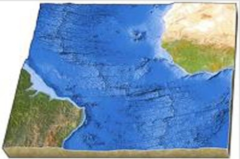
A)Island arc
B)Linear island chain
C)Subduction zone
D)Midocean ridge
E)None of these are correct.
A)Island arc
B)Linear island chain
C)Subduction zone
D)Midocean ridge
E)None of these are correct.
سؤال
سؤال
On this map,identify the letter that is over the Pacific Ocean. 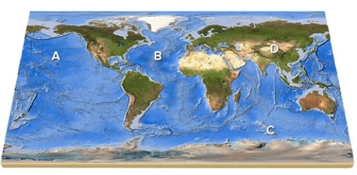
A)A
B)B
C)C
D)D
E)Feature is not labeled.
A)A
B)B
C)C
D)D
E)Feature is not labeled.
سؤال
In the diagram below,which layer is able to flow rather than being brittle? 
A)1 because water helps lubricate it
B)2 because the rocks are of a different composition than in the other layers
C)1,2,and 3 because it is not under as much pressure as 4
D)4 because it is under so much more pressure than 1,2,and 3
A)1 because water helps lubricate it
B)2 because the rocks are of a different composition than in the other layers
C)1,2,and 3 because it is not under as much pressure as 4
D)4 because it is under so much more pressure than 1,2,and 3
سؤال
The left-most block of wood is like a mountain range on Earth in that it 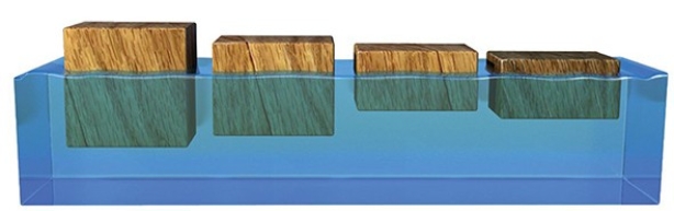
A)is composed of less dense materials and is a thick block (crust)compared to other blocks (land areas on Earth).
B)is composed of more dense materials and is a thick block (crust)compared to other blocks (land areas on Earth).
C)is over a part of the Earth where the mantle is unusually thin.
D)is underlain by ocean.
سؤال
سؤال
سؤال
Why does the Tibetan Plateau,shown in this figure,have a high elevation? 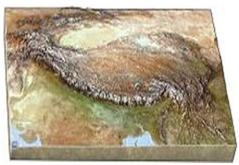
A)Transform faulting
B)Seafloor spreading
C)Continental rifting
D)Continental collision
E)Hot-spot activity
A)Transform faulting
B)Seafloor spreading
C)Continental rifting
D)Continental collision
E)Hot-spot activity
سؤال
On this map of the south Atlantic,why is the midocean ridge in the center of the ocean? 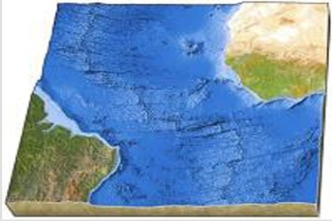
A)Subduction is consuming seafloor beneath both adjacent continents.
B)Seafloor is added to both sides during seafloor spreading.
C)Subduction has occurred under one and then another of the adjacent continents.
D)Seafloor spreading has stopped in this area.
A)Subduction is consuming seafloor beneath both adjacent continents.
B)Seafloor is added to both sides during seafloor spreading.
C)Subduction has occurred under one and then another of the adjacent continents.
D)Seafloor spreading has stopped in this area.
سؤال
سؤال
What type of plate boundary is depicted in this figure? 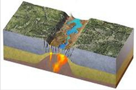
A)Continental rift
B)Ocean-ocean convergent boundary
C)Ocean-continent convergent boundary
D)Divergent and transform boundaries
E)Continental collision
A)Continental rift
B)Ocean-ocean convergent boundary
C)Ocean-continent convergent boundary
D)Divergent and transform boundaries
E)Continental collision
سؤال
سؤال
سؤال
سؤال
سؤال
Which areas on this world map are likely to be near a plate boundary? 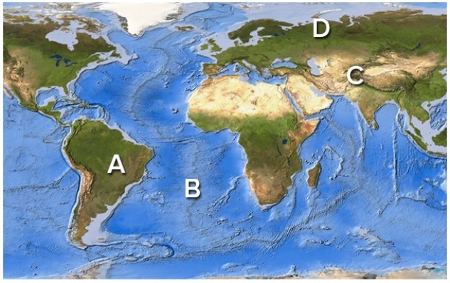
A)A and B
B)A and D
C)B and D
D)C and D
E)A,B,and C
A)A and B
B)A and D
C)B and D
D)C and D
E)A,B,and C
سؤال
سؤال
سؤال
سؤال
Which area(s)on this world map is likely to have volcanoes above sea level? 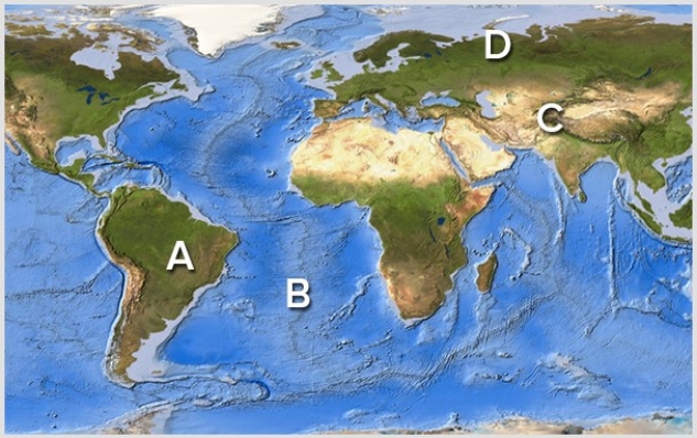
A)A
B)B
C)C
D)D
A)A
B)B
C)C
D)D
سؤال
Which area(s)on this world map is likely to have earthquakes? 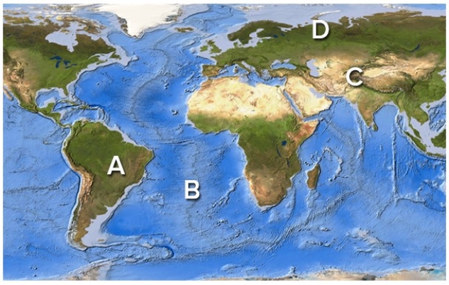
A)A
B)B
C)C
D)D
E)A,B,and C only
A)A
B)B
C)C
D)D
E)A,B,and C only
سؤال
What is being depicted by this figure? 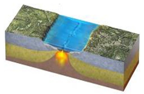
A)Continental collision
B)Continent-continent convergence
C)Early stages of seafloor spreading
D)Early stages of subduction
E)A boundary that is mostly a transform fault
A)Continental collision
B)Continent-continent convergence
C)Early stages of seafloor spreading
D)Early stages of subduction
E)A boundary that is mostly a transform fault
سؤال
What types of plate boundaries are shown in this figure? 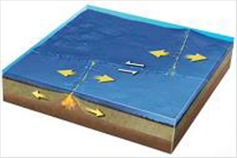
A)Divergent
B)Convergent
C)Transform
D)Divergent and transform
E)Convergent and divergent
A)Divergent
B)Convergent
C)Transform
D)Divergent and transform
E)Convergent and divergent
سؤال
What type of plate boundary is depicted in this figure? 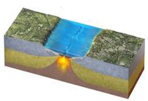
A)Oceanic divergent boundary
B)Ocean-ocean convergent boundary
C)Ocean-continent convergent boundary
D)Continental collision boundary
E)Transform boundary
A)Oceanic divergent boundary
B)Ocean-ocean convergent boundary
C)Ocean-continent convergent boundary
D)Continental collision boundary
E)Transform boundary
سؤال
This figure depicts what type of boundary? 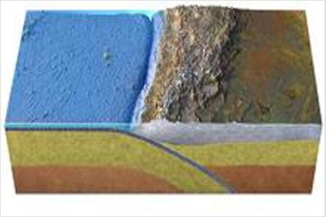
A)Oceanic divergent boundary
B)Ocean-ocean convergent boundary
C)Ocean-continent convergent boundary
D)Transform boundary
E)Continental collision
A)Oceanic divergent boundary
B)Ocean-ocean convergent boundary
C)Ocean-continent convergent boundary
D)Transform boundary
E)Continental collision
سؤال
سؤال
What type of plate boundary is depicted by the smaller arrows in the center of this figure? 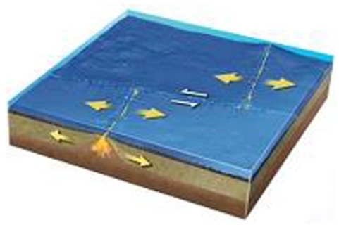
A)Divergent boundary
B)Convergent boundary
C)Transform boundary
D)Hot spot
E)None of these are correct.
A)Divergent boundary
B)Convergent boundary
C)Transform boundary
D)Hot spot
E)None of these are correct.
سؤال
Which way are the plates moving in this figure? 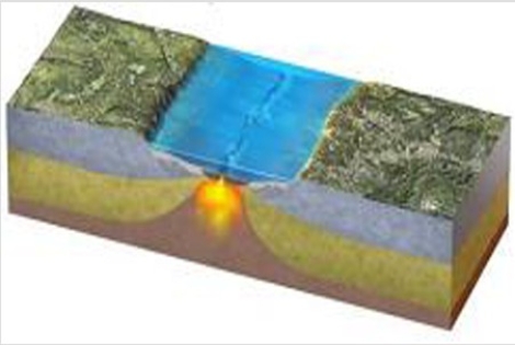
A)Away from each other
B)Directly toward each other
C)Toward each other at an angle
D)Horizontally sliding by one another
E)There is no way to tell.
A)Away from each other
B)Directly toward each other
C)Toward each other at an angle
D)Horizontally sliding by one another
E)There is no way to tell.
سؤال
سؤال
This diagram shows magnetic stripes on either side of the midocean ridge.How many times did the magnetic field change polarity to form all of the stripes shown here? 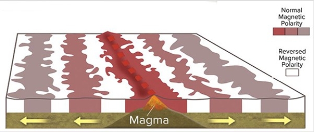
A)Twice
B)Three times
C)Five times
D)Eleven times
A)Twice
B)Three times
C)Five times
D)Eleven times
سؤال
سؤال
سؤال
Which feature on this figure is formed by the melting of the mantle above the slab? 
A)A
B)B
C)C
D)D
E)E
A)A
B)B
C)C
D)D
E)E
سؤال
سؤال
سؤال
What causes magnetic stripes on the seafloor,such as those shown here? 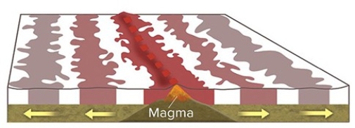
A)Volcanic rocks in oceanic crust are covered by a variable thickness of sediment.
B)Some oceanic crust consists of volcanic rocks and some is composed of sediment.
C)Sometimes Earth's magnetic field points north and sometimes it points south.
D)Some volcanic rocks are formed in normal ways and others have pillows.
سؤال
سؤال
Which feature on this figure is formed by bending of the subducted plate? 
A)A
B)B
C)C
D)D
E)E
A)A
B)B
C)C
D)D
E)E
سؤال
Which of the following is not happening in the area shown by this figure? 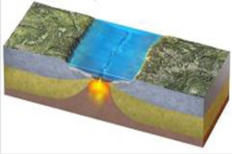
A)Plates are moving apart
B)Eruptions onto the seafloor
C)Release of water by a descending plate
D)Melting of rising mantle
E)Faulting
A)Plates are moving apart
B)Eruptions onto the seafloor
C)Release of water by a descending plate
D)Melting of rising mantle
E)Faulting
سؤال
On this figure of a continental collision,which continent would have had subduction-related magmatism? 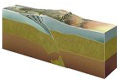
A)The continent on the left
B)The continent on the right
C)Both continents
D)Neither continent
A)The continent on the left
B)The continent on the right
C)Both continents
D)Neither continent
سؤال
On the accompanying figure,what type of feature is located in the area of letter C? 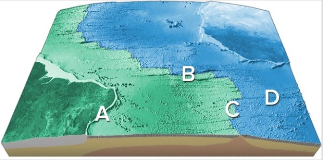
A)Transform fault
B)Midocean ridge
C)Linear island chain
D)Fracture zone
A)Transform fault
B)Midocean ridge
C)Linear island chain
D)Fracture zone
سؤال
On this map of the South Atlantic,which letter is on a transform fault? 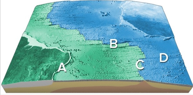
A)A
B)B
C)C
D)D
A)A
B)B
C)C
D)D
سؤال
سؤال
On the accompanying figure,what type of feature is located in the area of letter D? 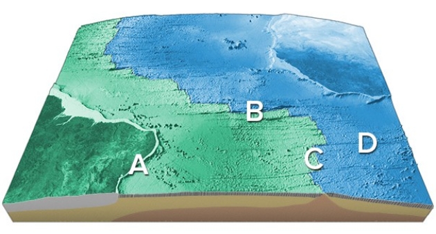
A)Transform fault
B)Midocean ridge
C)Linear island chain
D)Fracture zone
A)Transform fault
B)Midocean ridge
C)Linear island chain
D)Fracture zone
سؤال
On this map of the South Atlantic,which letter is on a site of seafloor spreading? 
A)A
B)B
C)C
D)D
A)A
B)B
C)C
D)D
سؤال
سؤال
On this map of the South Atlantic,which letter is on an oceanic fracture zone? 
A)A
B)B
C)C
D)D
A)A
B)B
C)C
D)D
سؤال
The plate boundary on this figure is located between 
A)A and B.
B)B and C.
C)C and D.
D)D and E.
E)There is not enough information to tell.
A)A and B.
B)B and C.
C)C and D.
D)D and E.
E)There is not enough information to tell.
سؤال
This diagram shows magnetic stripes on either side of the midocean ridge.How many different ages of stripes are represented in this diagram? 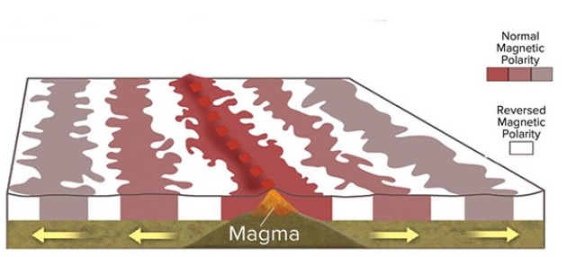
A)Two
B)Three
C)Four
D)Six
E)Eleven
A)Two
B)Three
C)Four
D)Six
E)Eleven
سؤال
Which numbered site is likely to have exposure of crystalline rocks? 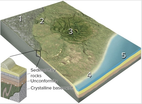
A)1,the continental shield
B)2,the continental platform
C)3,a basin in the continent
D)4,a continental shelf
E)5,a deep sediment-filled basin next to the continent
A)1,the continental shield
B)2,the continental platform
C)3,a basin in the continent
D)4,a continental shelf
E)5,a deep sediment-filled basin next to the continent
سؤال
سؤال
سؤال
سؤال
On this map of the area around Yellowstone,which feature is interpreted to record the position of the hot spot over time? 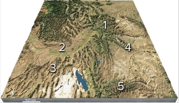
A)2,The Snake River Plain
B)3,The Uinta Mountains
C)4,The Bonneville Salt Flats
D)All of these are correct.
A)2,The Snake River Plain
B)3,The Uinta Mountains
C)4,The Bonneville Salt Flats
D)All of these are correct.
سؤال
سؤال
If the area shown in this figure is 240 kilometers wide and the oldest crest is 4 million years old,what was the approximate rate of seafloor spreading across this ridge? 
A)0.24 kilometers per million years
B)2.4 kilometers per million years
C)60 kilometers per million years
D)240 kilometers per million years
E)960 kilometers per million years
A)0.24 kilometers per million years
B)2.4 kilometers per million years
C)60 kilometers per million years
D)240 kilometers per million years
E)960 kilometers per million years
سؤال
سؤال
Which of the following happened to form the features in this region? 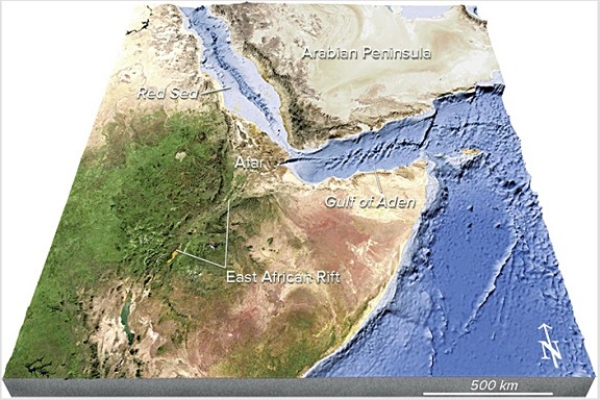
A)Formation of a continental hot spot
B)Continental rifting
C)Seafloor spreading
D)Volcanism that produced new land
E)All of these are correct.
A)Formation of a continental hot spot
B)Continental rifting
C)Seafloor spreading
D)Volcanism that produced new land
E)All of these are correct.
سؤال
سؤال
سؤال
Which feature is interpreted to be in the Yellowstone region (1)? 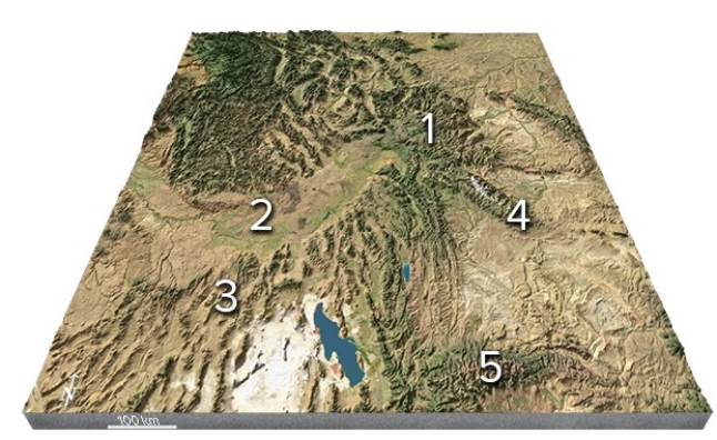
A)A continental collision
B)A meteorite impact
C)A continental hot spot
D)A foreland basin
A)A continental collision
B)A meteorite impact
C)A continental hot spot
D)A foreland basin
سؤال
سؤال
سؤال
The red dots that coincide with volcanically active island chains shown on the map are called 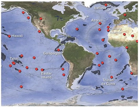
A)hot spots.
B)midocean ridges.
C)abyssal plains.
D)island arcs.
A)hot spots.
B)midocean ridges.
C)abyssal plains.
D)island arcs.
سؤال
سؤال
This figure shows a northwest-southeast line of islands and seamounts near Hawaii.If location 3 has the oldest rocks and Hawaii (1)has the youngest rocks,which way is the plate moving with respect to the hot spot? 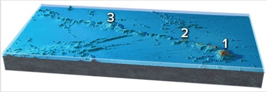
A)Northwest
B)Southeast
C)Northwest and southeast
D)It is not moving in a consistent direction.
A)Northwest
B)Southeast
C)Northwest and southeast
D)It is not moving in a consistent direction.
سؤال
سؤال
سؤال

فتح الحزمة
قم بالتسجيل لفتح البطاقات في هذه المجموعة!
Unlock Deck
Unlock Deck
1/137
العب
ملء الشاشة (f)
Deck 10: Plate Tectonics and Regional Features
1
In this figure of Japan,the offshore trenches indicate
A)continental rifting.
B)a rift in a midocean ridge formed by seafloor spreading.
C)a rift in a midocean ridge formed by transform faulting.
D)subduction of oceanic crust.
A)continental rifting.
B)a rift in a midocean ridge formed by seafloor spreading.
C)a rift in a midocean ridge formed by transform faulting.
D)subduction of oceanic crust.
D
2
On this map,identify the letter that is over a midocean ridge.
A)A
B)B
C)C
D)D
E)Feature is not labeled.
A)A
B)B
C)C
D)D
E)Feature is not labeled.
B
3
On this map,identify the letter that is over an island arc.
A)A
B)B
C)C
D)D
E)Feature is not labeled.
A)A
B)B
C)C
D)D
E)Feature is not labeled.
E
4
The hypothesis of continental drift was not widely accepted because
A)the hypothesis required that the entire Earth was once frozen.
B)the hypothesis required long,narrow land bridges that did not exist.
C)there was no mechanism to move continents through the oceanic crust.
D)All of these were reasons the hypothesis was not widely accepted.
A)the hypothesis required that the entire Earth was once frozen.
B)the hypothesis required long,narrow land bridges that did not exist.
C)there was no mechanism to move continents through the oceanic crust.
D)All of these were reasons the hypothesis was not widely accepted.
فتح الحزمة
افتح القفل للوصول البطاقات البالغ عددها 137 في هذه المجموعة.
فتح الحزمة
k this deck
5
Which of the layers in the diagram below are rigid?
A)1 and 2
B)2 and 3
C)1,2,and 3
D)All of them are correct.
A)1 and 2
B)2 and 3
C)1,2,and 3
D)All of them are correct.
فتح الحزمة
افتح القفل للوصول البطاقات البالغ عددها 137 في هذه المجموعة.
فتح الحزمة
k this deck
6
On this map,identify the letter that is over the Atlantic Ocean.
A)A
B)B
C)C
D)D
E)Feature is not labeled.
A)A
B)B
C)C
D)D
E)Feature is not labeled.
فتح الحزمة
افتح القفل للوصول البطاقات البالغ عددها 137 في هذه المجموعة.
فتح الحزمة
k this deck
7
On this southern continent,which side has a plate boundary?
A)The left (west)side
B)The right (east)side
C)Both sides
D)Neither side
A)The left (west)side
B)The right (east)side
C)Both sides
D)Neither side
فتح الحزمة
افتح القفل للوصول البطاقات البالغ عددها 137 في هذه المجموعة.
فتح الحزمة
k this deck
8
How did the Red Sea,shown between Arabia and Africa in this figure,form?
A)Subduction of Arabia beneath Africa
B)Subduction of Africa beneath Arabia
C)A continental collision
D)Continental rifting followed by seafloor spreading
E)Transform faulting followed by a continental collision
A)Subduction of Arabia beneath Africa
B)Subduction of Africa beneath Arabia
C)A continental collision
D)Continental rifting followed by seafloor spreading
E)Transform faulting followed by a continental collision
فتح الحزمة
افتح القفل للوصول البطاقات البالغ عددها 137 في هذه المجموعة.
فتح الحزمة
k this deck
9
In the diagram below,which layer(s)correspond to the mantle?
A)1 and 2
B)3
C)3 and 4
D)4
A)1 and 2
B)3
C)3 and 4
D)4
فتح الحزمة
افتح القفل للوصول البطاقات البالغ عددها 137 في هذه المجموعة.
فتح الحزمة
k this deck
10
Which of the following features is associated with a deep oceanic trench?
A)Midocean ridge
B)Linear island chain
C)Seamount
D)Island arc
A)Midocean ridge
B)Linear island chain
C)Seamount
D)Island arc
فتح الحزمة
افتح القفل للوصول البطاقات البالغ عددها 137 في هذه المجموعة.
فتح الحزمة
k this deck
11
Which of the following features is present on the seafloor off the Pacific Northwest?
A)World's largest oceanic plateau
B)Long,fairly straight fracture zone
C)World's largest linear island chain
D)Island arc within oceanic plates
A)World's largest oceanic plateau
B)Long,fairly straight fracture zone
C)World's largest linear island chain
D)Island arc within oceanic plates
فتح الحزمة
افتح القفل للوصول البطاقات البالغ عددها 137 في هذه المجموعة.
فتح الحزمة
k this deck
12
On this map of the south Atlantic,what is the feature that makes a zigzag pattern on the seafloor?
A)Island arc
B)Linear island chain
C)Subduction zone
D)Midocean ridge
E)None of these are correct.
A)Island arc
B)Linear island chain
C)Subduction zone
D)Midocean ridge
E)None of these are correct.
فتح الحزمة
افتح القفل للوصول البطاقات البالغ عددها 137 في هذه المجموعة.
فتح الحزمة
k this deck
13
Oceanic crust is
A)thinner and less dense than continental crust.
B)thinner and denser than continental crust.
C)thicker and less dense than continental crust.
D)thicker and denser than continental crust.
A)thinner and less dense than continental crust.
B)thinner and denser than continental crust.
C)thicker and less dense than continental crust.
D)thicker and denser than continental crust.
فتح الحزمة
افتح القفل للوصول البطاقات البالغ عددها 137 في هذه المجموعة.
فتح الحزمة
k this deck
14
On this map,identify the letter that is over the Pacific Ocean.
A)A
B)B
C)C
D)D
E)Feature is not labeled.
A)A
B)B
C)C
D)D
E)Feature is not labeled.
فتح الحزمة
افتح القفل للوصول البطاقات البالغ عددها 137 في هذه المجموعة.
فتح الحزمة
k this deck
15
In the diagram below,which layer is able to flow rather than being brittle?
A)1 because water helps lubricate it
B)2 because the rocks are of a different composition than in the other layers
C)1,2,and 3 because it is not under as much pressure as 4
D)4 because it is under so much more pressure than 1,2,and 3
A)1 because water helps lubricate it
B)2 because the rocks are of a different composition than in the other layers
C)1,2,and 3 because it is not under as much pressure as 4
D)4 because it is under so much more pressure than 1,2,and 3
فتح الحزمة
افتح القفل للوصول البطاقات البالغ عددها 137 في هذه المجموعة.
فتح الحزمة
k this deck
16
The left-most block of wood is like a mountain range on Earth in that it
A)is composed of less dense materials and is a thick block (crust)compared to other blocks (land areas on Earth).
B)is composed of more dense materials and is a thick block (crust)compared to other blocks (land areas on Earth).
C)is over a part of the Earth where the mantle is unusually thin.
D)is underlain by ocean.
فتح الحزمة
افتح القفل للوصول البطاقات البالغ عددها 137 في هذه المجموعة.
فتح الحزمة
k this deck
17
What ideas brought a renewed interest to the idea of continental drift?
A)Data that a submarine mountain occurred beneath the middle of the Atlantic Ocean
B)Evidence that the entire Earth was once frozen
C)Evidence that similar meteorites fall on different continents
D)Evidence that a large meteorite caused extinction of the dinosaurs
A)Data that a submarine mountain occurred beneath the middle of the Atlantic Ocean
B)Evidence that the entire Earth was once frozen
C)Evidence that similar meteorites fall on different continents
D)Evidence that a large meteorite caused extinction of the dinosaurs
فتح الحزمة
افتح القفل للوصول البطاقات البالغ عددها 137 في هذه المجموعة.
فتح الحزمة
k this deck
18
The most voluminous layer of Earth is the
A)crust.
B)mantle.
C)outer core.
D)inner core.
A)crust.
B)mantle.
C)outer core.
D)inner core.
فتح الحزمة
افتح القفل للوصول البطاقات البالغ عددها 137 في هذه المجموعة.
فتح الحزمة
k this deck
19
Why does the Tibetan Plateau,shown in this figure,have a high elevation?
A)Transform faulting
B)Seafloor spreading
C)Continental rifting
D)Continental collision
E)Hot-spot activity
A)Transform faulting
B)Seafloor spreading
C)Continental rifting
D)Continental collision
E)Hot-spot activity
فتح الحزمة
افتح القفل للوصول البطاقات البالغ عددها 137 في هذه المجموعة.
فتح الحزمة
k this deck
20
On this map of the south Atlantic,why is the midocean ridge in the center of the ocean?
A)Subduction is consuming seafloor beneath both adjacent continents.
B)Seafloor is added to both sides during seafloor spreading.
C)Subduction has occurred under one and then another of the adjacent continents.
D)Seafloor spreading has stopped in this area.
A)Subduction is consuming seafloor beneath both adjacent continents.
B)Seafloor is added to both sides during seafloor spreading.
C)Subduction has occurred under one and then another of the adjacent continents.
D)Seafloor spreading has stopped in this area.
فتح الحزمة
افتح القفل للوصول البطاقات البالغ عددها 137 في هذه المجموعة.
فتح الحزمة
k this deck
21
The main way new oceanic crust is created is by
A)eruption of lavas and solidification of magmas at depth.
B)sediment scraped off a subducting slab.
C)continents that subside below sea level.
D)continental rifting,before the continents separate.
E)magmas along an ocean-continent convergent boundary.
A)eruption of lavas and solidification of magmas at depth.
B)sediment scraped off a subducting slab.
C)continents that subside below sea level.
D)continental rifting,before the continents separate.
E)magmas along an ocean-continent convergent boundary.
فتح الحزمة
افتح القفل للوصول البطاقات البالغ عددها 137 في هذه المجموعة.
فتح الحزمة
k this deck
22
What type of plate boundary is depicted in this figure?
A)Continental rift
B)Ocean-ocean convergent boundary
C)Ocean-continent convergent boundary
D)Divergent and transform boundaries
E)Continental collision
A)Continental rift
B)Ocean-ocean convergent boundary
C)Ocean-continent convergent boundary
D)Divergent and transform boundaries
E)Continental collision
فتح الحزمة
افتح القفل للوصول البطاقات البالغ عددها 137 في هذه المجموعة.
فتح الحزمة
k this deck
23
Which data were used to develop the hypothesis of continental drift?
A)The shape of the continents
B)The distribution of fossils
C)The distribution of glacial deposits and directions of glacial scratch marks
D)All of these are correct.
A)The shape of the continents
B)The distribution of fossils
C)The distribution of glacial deposits and directions of glacial scratch marks
D)All of these are correct.
فتح الحزمة
افتح القفل للوصول البطاقات البالغ عددها 137 في هذه المجموعة.
فتح الحزمة
k this deck
24
Which of the following statements is true?
A)Earthquakes are more widespread than volcanoes or high mountains.
B)High mountains are more widespread than volcanoes or earthquakes.
C)Volcanoes are more widespread than earthquakes or high mountains.
A)Earthquakes are more widespread than volcanoes or high mountains.
B)High mountains are more widespread than volcanoes or earthquakes.
C)Volcanoes are more widespread than earthquakes or high mountains.
فتح الحزمة
افتح القفل للوصول البطاقات البالغ عددها 137 في هذه المجموعة.
فتح الحزمة
k this deck
25
The stages associated with continental rifting are,in order from earliest to latest,
A)narrow ocean basin,continental rift,uplift,wide ocean basin.
B)narrow ocean basin,wide ocean basin,continental rift,uplift.
C)uplift,wide ocean basin,narrow ocean basin,continental rift.
D)wide ocean basin,narrow ocean basin,uplift,continental rift.
E)uplift,continental rift,narrow ocean basin,wide ocean basin.
فتح الحزمة
افتح القفل للوصول البطاقات البالغ عددها 137 في هذه المجموعة.
فتح الحزمة
k this deck
26
What occurs at midocean ridges?
A)Oceanic crust is destroyed.
B)Continental crust is destroyed.
C)Oceanic crust is created.
D)Continental crust is created.
E)All crust is destroyed by magma.
A)Oceanic crust is destroyed.
B)Continental crust is destroyed.
C)Oceanic crust is created.
D)Continental crust is created.
E)All crust is destroyed by magma.
فتح الحزمة
افتح القفل للوصول البطاقات البالغ عددها 137 في هذه المجموعة.
فتح الحزمة
k this deck
27
Which areas on this world map are likely to be near a plate boundary?
A)A and B
B)A and D
C)B and D
D)C and D
E)A,B,and C
A)A and B
B)A and D
C)B and D
D)C and D
E)A,B,and C
فتح الحزمة
افتح القفل للوصول البطاقات البالغ عددها 137 في هذه المجموعة.
فتح الحزمة
k this deck
28
A convergent plate boundary is most likely associated with a(n)
A)oceanic trench.
B)a linear chain of island.
C)midocean ridge.
D)transform fault.
E)None of these are correct.
A)oceanic trench.
B)a linear chain of island.
C)midocean ridge.
D)transform fault.
E)None of these are correct.
فتح الحزمة
افتح القفل للوصول البطاقات البالغ عددها 137 في هذه المجموعة.
فتح الحزمة
k this deck
29
A divergent plate boundary is most likely associated with a(n)
A)oceanic trench.
B)mountain belt or island arc.
C)midocean ridge.
D)None of these are correct.
A)oceanic trench.
B)mountain belt or island arc.
C)midocean ridge.
D)None of these are correct.
فتح الحزمة
افتح القفل للوصول البطاقات البالغ عددها 137 في هذه المجموعة.
فتح الحزمة
k this deck
30
Midocean ridges form where two ocean plates
A)Collide.
B)Diverge.
C)Subduct.
D)Slide past each other.
E)Are destroyed.
A)Collide.
B)Diverge.
C)Subduct.
D)Slide past each other.
E)Are destroyed.
فتح الحزمة
افتح القفل للوصول البطاقات البالغ عددها 137 في هذه المجموعة.
فتح الحزمة
k this deck
31
Which area(s)on this world map is likely to have volcanoes above sea level?
A)A
B)B
C)C
D)D
A)A
B)B
C)C
D)D
فتح الحزمة
افتح القفل للوصول البطاقات البالغ عددها 137 في هذه المجموعة.
فتح الحزمة
k this deck
32
Which area(s)on this world map is likely to have earthquakes?
A)A
B)B
C)C
D)D
E)A,B,and C only
A)A
B)B
C)C
D)D
E)A,B,and C only
فتح الحزمة
افتح القفل للوصول البطاقات البالغ عددها 137 في هذه المجموعة.
فتح الحزمة
k this deck
33
What is being depicted by this figure?
A)Continental collision
B)Continent-continent convergence
C)Early stages of seafloor spreading
D)Early stages of subduction
E)A boundary that is mostly a transform fault
A)Continental collision
B)Continent-continent convergence
C)Early stages of seafloor spreading
D)Early stages of subduction
E)A boundary that is mostly a transform fault
فتح الحزمة
افتح القفل للوصول البطاقات البالغ عددها 137 في هذه المجموعة.
فتح الحزمة
k this deck
34
What types of plate boundaries are shown in this figure?
A)Divergent
B)Convergent
C)Transform
D)Divergent and transform
E)Convergent and divergent
A)Divergent
B)Convergent
C)Transform
D)Divergent and transform
E)Convergent and divergent
فتح الحزمة
افتح القفل للوصول البطاقات البالغ عددها 137 في هذه المجموعة.
فتح الحزمة
k this deck
35
What type of plate boundary is depicted in this figure?
A)Oceanic divergent boundary
B)Ocean-ocean convergent boundary
C)Ocean-continent convergent boundary
D)Continental collision boundary
E)Transform boundary
A)Oceanic divergent boundary
B)Ocean-ocean convergent boundary
C)Ocean-continent convergent boundary
D)Continental collision boundary
E)Transform boundary
فتح الحزمة
افتح القفل للوصول البطاقات البالغ عددها 137 في هذه المجموعة.
فتح الحزمة
k this deck
36
This figure depicts what type of boundary?
A)Oceanic divergent boundary
B)Ocean-ocean convergent boundary
C)Ocean-continent convergent boundary
D)Transform boundary
E)Continental collision
A)Oceanic divergent boundary
B)Ocean-ocean convergent boundary
C)Ocean-continent convergent boundary
D)Transform boundary
E)Continental collision
فتح الحزمة
افتح القفل للوصول البطاقات البالغ عددها 137 في هذه المجموعة.
فتح الحزمة
k this deck
37
Midocean ridges are higher than surrounding oceanic crust primarily because
A)two plates are colliding.
B)the crust is thicker and stronger.
C)transform faulting uplifts the rocks.
D)the lithosphere is thinner and hotter.
A)two plates are colliding.
B)the crust is thicker and stronger.
C)transform faulting uplifts the rocks.
D)the lithosphere is thinner and hotter.
فتح الحزمة
افتح القفل للوصول البطاقات البالغ عددها 137 في هذه المجموعة.
فتح الحزمة
k this deck
38
What type of plate boundary is depicted by the smaller arrows in the center of this figure?
A)Divergent boundary
B)Convergent boundary
C)Transform boundary
D)Hot spot
E)None of these are correct.
A)Divergent boundary
B)Convergent boundary
C)Transform boundary
D)Hot spot
E)None of these are correct.
فتح الحزمة
افتح القفل للوصول البطاقات البالغ عددها 137 في هذه المجموعة.
فتح الحزمة
k this deck
39
Which way are the plates moving in this figure?
A)Away from each other
B)Directly toward each other
C)Toward each other at an angle
D)Horizontally sliding by one another
E)There is no way to tell.
A)Away from each other
B)Directly toward each other
C)Toward each other at an angle
D)Horizontally sliding by one another
E)There is no way to tell.
فتح الحزمة
افتح القفل للوصول البطاقات البالغ عددها 137 في هذه المجموعة.
فتح الحزمة
k this deck
40
An oceanic transform plate boundary is most likely associated with a(n)
A)oceanic trench.
B)mountain belt or island arc.
C)midocean ridge.
D)All of these are correct.
A)oceanic trench.
B)mountain belt or island arc.
C)midocean ridge.
D)All of these are correct.
فتح الحزمة
افتح القفل للوصول البطاقات البالغ عددها 137 في هذه المجموعة.
فتح الحزمة
k this deck
41
This diagram shows magnetic stripes on either side of the midocean ridge.How many times did the magnetic field change polarity to form all of the stripes shown here?
A)Twice
B)Three times
C)Five times
D)Eleven times
A)Twice
B)Three times
C)Five times
D)Eleven times
فتح الحزمة
افتح القفل للوصول البطاقات البالغ عددها 137 في هذه المجموعة.
فتح الحزمة
k this deck
42
Which of the following is associated with a midocean ridge?
A)An island arc
B)Magma produced as the mantles rise up
C)Melting of the subducting plate
D)Lower topography than surrounding seafloor
E)Continental rift
A)An island arc
B)Magma produced as the mantles rise up
C)Melting of the subducting plate
D)Lower topography than surrounding seafloor
E)Continental rift
فتح الحزمة
افتح القفل للوصول البطاقات البالغ عددها 137 في هذه المجموعة.
فتح الحزمة
k this deck
43
How fast do plates move relative to one another?
A)Centimeters per year
B)Meters per year
C)Kilometers per year
D)One hundred kilometers per year
A)Centimeters per year
B)Meters per year
C)Kilometers per year
D)One hundred kilometers per year
فتح الحزمة
افتح القفل للوصول البطاقات البالغ عددها 137 في هذه المجموعة.
فتح الحزمة
k this deck
44
Which feature on this figure is formed by the melting of the mantle above the slab?
A)A
B)B
C)C
D)D
E)E
A)A
B)B
C)C
D)D
E)E
فتح الحزمة
افتح القفل للوصول البطاقات البالغ عددها 137 في هذه المجموعة.
فتح الحزمة
k this deck
45
A force that is important in driving plate tectonics is
A)slab pull.
B)ridge push.
C)upwelling mantle,such as in hot spots.
D)All of these are correct.
A)slab pull.
B)ridge push.
C)upwelling mantle,such as in hot spots.
D)All of these are correct.
فتح الحزمة
افتح القفل للوصول البطاقات البالغ عددها 137 في هذه المجموعة.
فتح الحزمة
k this deck
46
The Earth's magnetic field is generated by
A)salty water moving through the deep parts of the crust.
B)convection currents in the asthenosphere.
C)movement of iron and electrical currents within Earth's outer core.
D)aligned magnetic minerals within Earth's inner core.
A)salty water moving through the deep parts of the crust.
B)convection currents in the asthenosphere.
C)movement of iron and electrical currents within Earth's outer core.
D)aligned magnetic minerals within Earth's inner core.
فتح الحزمة
افتح القفل للوصول البطاقات البالغ عددها 137 في هذه المجموعة.
فتح الحزمة
k this deck
47
What causes magnetic stripes on the seafloor,such as those shown here?
A)Volcanic rocks in oceanic crust are covered by a variable thickness of sediment.
B)Some oceanic crust consists of volcanic rocks and some is composed of sediment.
C)Sometimes Earth's magnetic field points north and sometimes it points south.
D)Some volcanic rocks are formed in normal ways and others have pillows.
فتح الحزمة
افتح القفل للوصول البطاقات البالغ عددها 137 في هذه المجموعة.
فتح الحزمة
k this deck
48
Which of the following best represents the sequence by which a continent splits apart?
A)Seafloor spreading,then continental rifting,then uplift due to mantle upwelling
B)Continental rifting,then seafloor spreading,then uplift due to mantle upwelling
C)Uplift due to mantle upwelling,then continental rifting,then seafloor spreading
D)None of these are correct.
A)Seafloor spreading,then continental rifting,then uplift due to mantle upwelling
B)Continental rifting,then seafloor spreading,then uplift due to mantle upwelling
C)Uplift due to mantle upwelling,then continental rifting,then seafloor spreading
D)None of these are correct.
فتح الحزمة
افتح القفل للوصول البطاقات البالغ عددها 137 في هذه المجموعة.
فتح الحزمة
k this deck
49
Which feature on this figure is formed by bending of the subducted plate?
A)A
B)B
C)C
D)D
E)E
A)A
B)B
C)C
D)D
E)E
فتح الحزمة
افتح القفل للوصول البطاقات البالغ عددها 137 في هذه المجموعة.
فتح الحزمة
k this deck
50
Which of the following is not happening in the area shown by this figure?
A)Plates are moving apart
B)Eruptions onto the seafloor
C)Release of water by a descending plate
D)Melting of rising mantle
E)Faulting
A)Plates are moving apart
B)Eruptions onto the seafloor
C)Release of water by a descending plate
D)Melting of rising mantle
E)Faulting
فتح الحزمة
افتح القفل للوصول البطاقات البالغ عددها 137 في هذه المجموعة.
فتح الحزمة
k this deck
51
On this figure of a continental collision,which continent would have had subduction-related magmatism?
A)The continent on the left
B)The continent on the right
C)Both continents
D)Neither continent
A)The continent on the left
B)The continent on the right
C)Both continents
D)Neither continent
فتح الحزمة
افتح القفل للوصول البطاقات البالغ عددها 137 في هذه المجموعة.
فتح الحزمة
k this deck
52
On the accompanying figure,what type of feature is located in the area of letter C?
A)Transform fault
B)Midocean ridge
C)Linear island chain
D)Fracture zone
A)Transform fault
B)Midocean ridge
C)Linear island chain
D)Fracture zone
فتح الحزمة
افتح القفل للوصول البطاقات البالغ عددها 137 في هذه المجموعة.
فتح الحزمة
k this deck
53
On this map of the South Atlantic,which letter is on a transform fault?
A)A
B)B
C)C
D)D
A)A
B)B
C)C
D)D
فتح الحزمة
افتح القفل للوصول البطاقات البالغ عددها 137 في هذه المجموعة.
فتح الحزمة
k this deck
54
Which of the following contains a modern continental rift?
A)Eastern North America
B)Eastern Africa
C)Eastern Europe
D)Eastern Pacific Ocean
E)East Timor
A)Eastern North America
B)Eastern Africa
C)Eastern Europe
D)Eastern Pacific Ocean
E)East Timor
فتح الحزمة
افتح القفل للوصول البطاقات البالغ عددها 137 في هذه المجموعة.
فتح الحزمة
k this deck
55
On the accompanying figure,what type of feature is located in the area of letter D?
A)Transform fault
B)Midocean ridge
C)Linear island chain
D)Fracture zone
A)Transform fault
B)Midocean ridge
C)Linear island chain
D)Fracture zone
فتح الحزمة
افتح القفل للوصول البطاقات البالغ عددها 137 في هذه المجموعة.
فتح الحزمة
k this deck
56
On this map of the South Atlantic,which letter is on a site of seafloor spreading?
A)A
B)B
C)C
D)D
A)A
B)B
C)C
D)D
فتح الحزمة
افتح القفل للوصول البطاقات البالغ عددها 137 في هذه المجموعة.
فتح الحزمة
k this deck
57
A continent has an oceanic trench offshore of its coast.Which of the following is probably not present along this side of the continent?
A)A mountain belt
B)Earthquakes
C)Volcanoes
D)Melting along a midocean ridge
E)Subduction of an oceanic plate
A)A mountain belt
B)Earthquakes
C)Volcanoes
D)Melting along a midocean ridge
E)Subduction of an oceanic plate
فتح الحزمة
افتح القفل للوصول البطاقات البالغ عددها 137 في هذه المجموعة.
فتح الحزمة
k this deck
58
On this map of the South Atlantic,which letter is on an oceanic fracture zone?
A)A
B)B
C)C
D)D
A)A
B)B
C)C
D)D
فتح الحزمة
افتح القفل للوصول البطاقات البالغ عددها 137 في هذه المجموعة.
فتح الحزمة
k this deck
59
The plate boundary on this figure is located between
A)A and B.
B)B and C.
C)C and D.
D)D and E.
E)There is not enough information to tell.
A)A and B.
B)B and C.
C)C and D.
D)D and E.
E)There is not enough information to tell.
فتح الحزمة
افتح القفل للوصول البطاقات البالغ عددها 137 في هذه المجموعة.
فتح الحزمة
k this deck
60
This diagram shows magnetic stripes on either side of the midocean ridge.How many different ages of stripes are represented in this diagram?
A)Two
B)Three
C)Four
D)Six
E)Eleven
A)Two
B)Three
C)Four
D)Six
E)Eleven
فتح الحزمة
افتح القفل للوصول البطاقات البالغ عددها 137 في هذه المجموعة.
فتح الحزمة
k this deck
61
Which numbered site is likely to have exposure of crystalline rocks?
A)1,the continental shield
B)2,the continental platform
C)3,a basin in the continent
D)4,a continental shelf
E)5,a deep sediment-filled basin next to the continent
A)1,the continental shield
B)2,the continental platform
C)3,a basin in the continent
D)4,a continental shelf
E)5,a deep sediment-filled basin next to the continent
فتح الحزمة
افتح القفل للوصول البطاقات البالغ عددها 137 في هذه المجموعة.
فتح الحزمة
k this deck
62
Hot spots form linear island chains because
A)the plate moves relative to the underlying hot spot.
B)they are aligned with trenches formed by subduction.
C)they occur along the midoceanic ridges.
A)the plate moves relative to the underlying hot spot.
B)they are aligned with trenches formed by subduction.
C)they occur along the midoceanic ridges.
فتح الحزمة
افتح القفل للوصول البطاقات البالغ عددها 137 في هذه المجموعة.
فتح الحزمة
k this deck
63
What do the island chains of Hawaii,Tahiti,and Tristan da Cunha have in common?
A)They formed from hot spots.
B)They are part of island arcs.
C)They are part of an oceanic plateau.
A)They formed from hot spots.
B)They are part of island arcs.
C)They are part of an oceanic plateau.
فتح الحزمة
افتح القفل للوصول البطاقات البالغ عددها 137 في هذه المجموعة.
فتح الحزمة
k this deck
64
What can a continental hot spot lead to?
A)Formation of a curved continental outline along two rifts
B)Localization of a river and delta along the failed arm of the rift
C)A thick accumulation of basalts and other volcanic rocks
D)A region that is high in elevation relative to adjacent parts of the continent
E)All of these are correct.
A)Formation of a curved continental outline along two rifts
B)Localization of a river and delta along the failed arm of the rift
C)A thick accumulation of basalts and other volcanic rocks
D)A region that is high in elevation relative to adjacent parts of the continent
E)All of these are correct.
فتح الحزمة
افتح القفل للوصول البطاقات البالغ عددها 137 في هذه المجموعة.
فتح الحزمة
k this deck
65
On this map of the area around Yellowstone,which feature is interpreted to record the position of the hot spot over time?
A)2,The Snake River Plain
B)3,The Uinta Mountains
C)4,The Bonneville Salt Flats
D)All of these are correct.
A)2,The Snake River Plain
B)3,The Uinta Mountains
C)4,The Bonneville Salt Flats
D)All of these are correct.
فتح الحزمة
افتح القفل للوصول البطاقات البالغ عددها 137 في هذه المجموعة.
فتح الحزمة
k this deck
66
What can occur during the evolution of a hot spot?
A)An initial period of subsidence as magmas rise from the mantle
B)Formation of a fold and thrust belt
C)Formation of rifts that radiate out from the hot spot
D)Thickening of the crust beneath a passive margin
E)None of these are correct.
A)An initial period of subsidence as magmas rise from the mantle
B)Formation of a fold and thrust belt
C)Formation of rifts that radiate out from the hot spot
D)Thickening of the crust beneath a passive margin
E)None of these are correct.
فتح الحزمة
افتح القفل للوصول البطاقات البالغ عددها 137 في هذه المجموعة.
فتح الحزمة
k this deck
67
If the area shown in this figure is 240 kilometers wide and the oldest crest is 4 million years old,what was the approximate rate of seafloor spreading across this ridge?
A)0.24 kilometers per million years
B)2.4 kilometers per million years
C)60 kilometers per million years
D)240 kilometers per million years
E)960 kilometers per million years
A)0.24 kilometers per million years
B)2.4 kilometers per million years
C)60 kilometers per million years
D)240 kilometers per million years
E)960 kilometers per million years
فتح الحزمة
افتح القفل للوصول البطاقات البالغ عددها 137 في هذه المجموعة.
فتح الحزمة
k this deck
68
Which of the following is not interpreted to be related to a continental hot spot?
A)Afar region of east Africa
B)High elevations of Tibet
C)Yellowstone
D)Snake River Plain of Idaho
E)All of these are related to a continental hot spot.
A)Afar region of east Africa
B)High elevations of Tibet
C)Yellowstone
D)Snake River Plain of Idaho
E)All of these are related to a continental hot spot.
فتح الحزمة
افتح القفل للوصول البطاقات البالغ عددها 137 في هذه المجموعة.
فتح الحزمة
k this deck
69
Which of the following happened to form the features in this region?
A)Formation of a continental hot spot
B)Continental rifting
C)Seafloor spreading
D)Volcanism that produced new land
E)All of these are correct.
A)Formation of a continental hot spot
B)Continental rifting
C)Seafloor spreading
D)Volcanism that produced new land
E)All of these are correct.
فتح الحزمة
افتح القفل للوصول البطاقات البالغ عددها 137 في هذه المجموعة.
فتح الحزمة
k this deck
70
If you wanted to locate hot spots on Earth,which of the following would not be good place to look?
A)The volcanically active end of a linear island chain
B)Clusters of volcanically active islands
C)Hawaii and the Galapagos
D)All of these would be good places.
A)The volcanically active end of a linear island chain
B)Clusters of volcanically active islands
C)Hawaii and the Galapagos
D)All of these would be good places.
فتح الحزمة
افتح القفل للوصول البطاقات البالغ عددها 137 في هذه المجموعة.
فتح الحزمة
k this deck
71
Most oceanic plateaus are
A)small pieces rifted apart from continents.
B)places where the seafloor has been buckled upward by convergence.
C)constructed by volcanic eruptions probably over mantle plumes.
D)large fan-shaped mounds deposited by turbidity currents.
A)small pieces rifted apart from continents.
B)places where the seafloor has been buckled upward by convergence.
C)constructed by volcanic eruptions probably over mantle plumes.
D)large fan-shaped mounds deposited by turbidity currents.
فتح الحزمة
افتح القفل للوصول البطاقات البالغ عددها 137 في هذه المجموعة.
فتح الحزمة
k this deck
72
Which feature is interpreted to be in the Yellowstone region (1)?
A)A continental collision
B)A meteorite impact
C)A continental hot spot
D)A foreland basin
A)A continental collision
B)A meteorite impact
C)A continental hot spot
D)A foreland basin
فتح الحزمة
افتح القفل للوصول البطاقات البالغ عددها 137 في هذه المجموعة.
فتح الحزمة
k this deck
73
What is associated with reversed magnetic polarity?
A)A compass needle would point south.
B)The magnetic signal of seafloor formed with this polarity would be stronger compared to adjacent areas of the seafloor.
C)There are much fewer intervals of reversed polarity than normal polarity.
D)All of these are correct.
A)A compass needle would point south.
B)The magnetic signal of seafloor formed with this polarity would be stronger compared to adjacent areas of the seafloor.
C)There are much fewer intervals of reversed polarity than normal polarity.
D)All of these are correct.
فتح الحزمة
افتح القفل للوصول البطاقات البالغ عددها 137 في هذه المجموعة.
فتح الحزمة
k this deck
74
Oceanic plateaus form from basaltic volcanism originating from
A)hot spots.
B)midocean ridges.
C)trenches.
A)hot spots.
B)midocean ridges.
C)trenches.
فتح الحزمة
افتح القفل للوصول البطاقات البالغ عددها 137 في هذه المجموعة.
فتح الحزمة
k this deck
75
The red dots that coincide with volcanically active island chains shown on the map are called
A)hot spots.
B)midocean ridges.
C)abyssal plains.
D)island arcs.
A)hot spots.
B)midocean ridges.
C)abyssal plains.
D)island arcs.
فتح الحزمة
افتح القفل للوصول البطاقات البالغ عددها 137 في هذه المجموعة.
فتح الحزمة
k this deck
76
Most oceanic islands and seamounts are
A)small pieces rifted apart from continents.
B)places where the seafloor has been buckled upward by convergence.
C)constructed by volcanic eruptions that first occur under water.
D)large fan-shaped mounds deposited by turbidity currents.
A)small pieces rifted apart from continents.
B)places where the seafloor has been buckled upward by convergence.
C)constructed by volcanic eruptions that first occur under water.
D)large fan-shaped mounds deposited by turbidity currents.
فتح الحزمة
افتح القفل للوصول البطاقات البالغ عددها 137 في هذه المجموعة.
فتح الحزمة
k this deck
77
This figure shows a northwest-southeast line of islands and seamounts near Hawaii.If location 3 has the oldest rocks and Hawaii (1)has the youngest rocks,which way is the plate moving with respect to the hot spot?
A)Northwest
B)Southeast
C)Northwest and southeast
D)It is not moving in a consistent direction.
A)Northwest
B)Southeast
C)Northwest and southeast
D)It is not moving in a consistent direction.
فتح الحزمة
افتح القفل للوصول البطاقات البالغ عددها 137 في هذه المجموعة.
فتح الحزمة
k this deck
78
What is a use of understanding magnetic reversals?
A)Matching the patterns of reversals in a rock sequence to the magnetic timescale
B)Studying magnetic stripes on the seafloor
C)Calculating rates of seafloor spreading
D)All of these are correct.
A)Matching the patterns of reversals in a rock sequence to the magnetic timescale
B)Studying magnetic stripes on the seafloor
C)Calculating rates of seafloor spreading
D)All of these are correct.
فتح الحزمة
افتح القفل للوصول البطاقات البالغ عددها 137 في هذه المجموعة.
فتح الحزمة
k this deck
79
What rock type forms oceanic plateaus?
A)Basalt
B)Granite
C)Rhyolite
A)Basalt
B)Granite
C)Rhyolite
فتح الحزمة
افتح القفل للوصول البطاقات البالغ عددها 137 في هذه المجموعة.
فتح الحزمة
k this deck
80
If you drilled into an oceanic plateau,you would most likely find
A)a thin layer of oceanic sediment over continental crust.
B)andesitic volcanoes buried by turbidity currents.
C)a normal thickness of oceanic crust overlain by andesitic volcanoes.
D)large amounts of basalt derived from melting in the mantle.
A)a thin layer of oceanic sediment over continental crust.
B)andesitic volcanoes buried by turbidity currents.
C)a normal thickness of oceanic crust overlain by andesitic volcanoes.
D)large amounts of basalt derived from melting in the mantle.
فتح الحزمة
افتح القفل للوصول البطاقات البالغ عددها 137 في هذه المجموعة.
فتح الحزمة
k this deck
فتح الحزمة
افتح القفل للوصول البطاقات البالغ عددها 137 في هذه المجموعة.


