Deck 17: Glacial Landscapes and the Cryosphere
ملء الشاشة (f)
سؤال
سؤال
سؤال
سؤال
سؤال
سؤال
سؤال
سؤال
سؤال
سؤال
سؤال
سؤال
سؤال
سؤال
سؤال
سؤال
سؤال
سؤال
سؤال
سؤال
سؤال
سؤال
سؤال
سؤال
سؤال
سؤال
سؤال
سؤال
سؤال
سؤال
سؤال
سؤال
سؤال
سؤال
سؤال
سؤال
سؤال
سؤال
سؤال
سؤال
سؤال
سؤال
سؤال
سؤال
سؤال
سؤال
سؤال
سؤال
سؤال
سؤال
سؤال
سؤال
سؤال
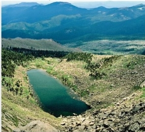 are small mountain lakes formed in cirques.
A)Cols
B)Horns
C)Hanging valleys
D)Arêtes
E)Tarns
سؤال
سؤال
سؤال
سؤال
سؤال
سؤال
سؤال
سؤال
سؤال
سؤال
سؤال
سؤال
سؤال
سؤال
سؤال
سؤال
سؤال
سؤال
سؤال
سؤال
سؤال
سؤال
سؤال
سؤال
سؤال
سؤال
سؤال

فتح الحزمة
قم بالتسجيل لفتح البطاقات في هذه المجموعة!
Unlock Deck
Unlock Deck
1/98
العب
ملء الشاشة (f)
Deck 17: Glacial Landscapes and the Cryosphere
1
A glacier confined in a bowl-shaped recess is known as a(n)
A)cirque glacier.
B)valley glacier.
C)piedmont glacier.
D)tidewater glacier.
E)ice shelf.
A)cirque glacier.
B)valley glacier.
C)piedmont glacier.
D)tidewater glacier.
E)ice shelf.
A
2
Which of the following is a primary cause of snow avalanches?
A)earthquakes
B)volcanic eruptions
C)saturated slope materials
D)freeze-thaw cycles in soils
E)slab overlying a weaker layer of snow
A)earthquakes
B)volcanic eruptions
C)saturated slope materials
D)freeze-thaw cycles in soils
E)slab overlying a weaker layer of snow
E
3
The two main types of glaciers are
A)alpine glaciers and continental ice sheets.
B)moraine glaciers and alpine glaciers.
C)tidewater glaciers and continental glaciers.
D)cirque glaciers and alpine glaciers.
E)valley glaciers and continental ice sheets.
A)alpine glaciers and continental ice sheets.
B)moraine glaciers and alpine glaciers.
C)tidewater glaciers and continental glaciers.
D)cirque glaciers and alpine glaciers.
E)valley glaciers and continental ice sheets.
A
4
A general term for a mass of perennial ice,resting on land or floating in the sea attached to a landmass is
A)the snowline.
B)an iceberg.
C)a glacier.
D)a moraine.
E)a firn.
A)the snowline.
B)an iceberg.
C)a glacier.
D)a moraine.
E)a firn.
فتح الحزمة
افتح القفل للوصول البطاقات البالغ عددها 98 في هذه المجموعة.
فتح الحزمة
k this deck
5
Several valley glaciers coalescing at the base of a mountain range form a(n)
A)cirque glacier.
B)ice cap.
C)piedmont glacier.
D)tidewater glacier.
E)terminal moraine.
A)cirque glacier.
B)ice cap.
C)piedmont glacier.
D)tidewater glacier.
E)terminal moraine.
فتح الحزمة
افتح القفل للوصول البطاقات البالغ عددها 98 في هذه المجموعة.
فتح الحزمة
k this deck
6
Which of the following is correct regarding valley glaciers?
A)The snowfield sources for these glaciers are usually found right at the snowline.
B)They occur in an unconfined environment-like an open plain.
C)They may range in length from 100 m (325 ft. )to 100 km (60 mi. ).
D)They remain stationary and do not move.
E)They are also called ice caps.
A)The snowfield sources for these glaciers are usually found right at the snowline.
B)They occur in an unconfined environment-like an open plain.
C)They may range in length from 100 m (325 ft. )to 100 km (60 mi. ).
D)They remain stationary and do not move.
E)They are also called ice caps.
فتح الحزمة
افتح القفل للوصول البطاقات البالغ عددها 98 في هذه المجموعة.
فتح الحزمة
k this deck
7
The rapid change of snowflakes as they are on the ground is known as
A)snow metamorphism.
B)sublimation.
C)deposition.
D)saltation.
E)traction.
A)snow metamorphism.
B)sublimation.
C)deposition.
D)saltation.
E)traction.
فتح الحزمة
افتح القفل للوصول البطاقات البالغ عددها 98 في هذه المجموعة.
فتح الحزمة
k this deck
8
Presently,glaciers cover approximately percent of Earth's land area.
A)3
B)7
C)10
D)15
E)22
A)3
B)7
C)10
D)15
E)22
فتح الحزمة
افتح القفل للوصول البطاقات البالغ عددها 98 في هذه المجموعة.
فتح الحزمة
k this deck
9
Approximately,what percentage of the Earth's freshwater is frozen?
A)10%
B)15%
C)25%
D)50%
E)75%
A)10%
B)15%
C)25%
D)50%
E)75%
فتح الحزمة
افتح القفل للوصول البطاقات البالغ عددها 98 في هذه المجموعة.
فتح الحزمة
k this deck
10
Which of the following is correct regarding the snowline?
A)It increases in elevation with increasing latitude.
B)It decreases in elevation with increasing latitude.
C)It occurs at approximately the same elevation at all latitudes because the environmental lapse rate is approximately the same at all latitudes.
D)It varies randomly and unpredictably.
E)It occurs at approximately the same elevation at all longitudes because the environmental lapse rate is approximately the same at all longitudes.
فتح الحزمة
افتح القفل للوصول البطاقات البالغ عددها 98 في هذه المجموعة.
فتح الحزمة
k this deck
11
The transformation of snow into glacial ice in Antarctica takes _ than (as)in midlatitude alpine glaciers because .
A)less time;more snow fall in the polar regions each year speeds the glacier formation process
B)less time;there is more melting and refreezing in the midlatitudes and,therefore,it takes much longer there
C)longer;the long summer days in Antarctica (up to 24-hours)results in more sunlight impeding the glacier development process
D)longer;the dryness of the Antarctic climate and minimal snowfall as compared to wetter climates with constant snowfall
E)approximately the same time;the processes and conditions for formation are the same in both regions
فتح الحزمة
افتح القفل للوصول البطاقات البالغ عددها 98 في هذه المجموعة.
فتح الحزمة
k this deck
12
Glacial ice is
A)essentially the same as snow.
B)produced over a period of many years.
C)composed primarily of sedimentary rock.
D)generally less dense than snow and firn.
E)annually formed high altitudes and latitudes in fall and melts away by spring/early summer.
A)essentially the same as snow.
B)produced over a period of many years.
C)composed primarily of sedimentary rock.
D)generally less dense than snow and firn.
E)annually formed high altitudes and latitudes in fall and melts away by spring/early summer.
فتح الحزمة
افتح القفل للوصول البطاقات البالغ عددها 98 في هذه المجموعة.
فتح الحزمة
k this deck
13
A glacier confined within a valley that originally was formed by stream action is called a(n)
A)ice cap.
B)cirque glacier.
C)valley glacier.
D)tidewater glacier.
E)piedmont glacier.
A)ice cap.
B)cirque glacier.
C)valley glacier.
D)tidewater glacier.
E)piedmont glacier.
فتح الحزمة
افتح القفل للوصول البطاقات البالغ عددها 98 في هذه المجموعة.
فتح الحزمة
k this deck
14
The bulk of ice on Earth is in
A)North America,specifically Alaska.
B)European and Asian mountain ranges.
C)Greenland and Antarctica.
D)floating ice shelves and packs.
E)Argentina and Chile.
A)North America,specifically Alaska.
B)European and Asian mountain ranges.
C)Greenland and Antarctica.
D)floating ice shelves and packs.
E)Argentina and Chile.
فتح الحزمة
افتح القفل للوصول البطاقات البالغ عددها 98 في هذه المجموعة.
فتح الحزمة
k this deck
15
Why is glacial ice analogous to a metamorphic rock?
A)It has a definite chemical composition.
B)It has a crystalline structure.
C)It forms as a result of recrystallization caused by pressure.
D)It is solid.
E)It is inorganic.
A)It has a definite chemical composition.
B)It has a crystalline structure.
C)It forms as a result of recrystallization caused by pressure.
D)It is solid.
E)It is inorganic.
فتح الحزمة
افتح القفل للوصول البطاقات البالغ عددها 98 في هذه المجموعة.
فتح الحزمة
k this deck
16
A snowline refers to
A)the latitude or elevation at which winter snow accumulates each year.
B)the latitude demarcating the extent of glacial ice during the last glacial maximum.
C)an isoline demarcating the extent of snow or ice on a weather map.
D)the lowest line (latitude or elevation)where winter snow accumulation persists throughout the summer.
E)the elevation at which snow accumulation ceases,marking the uppermost point of a glacier.
فتح الحزمة
افتح القفل للوصول البطاقات البالغ عددها 98 في هذه المجموعة.
فتح الحزمة
k this deck
17
Alpine glaciers include all of the following except a(n)
A)ice cap.
B)piedmont glacier.
C)cirque glacier.
D)valley glacier.
E)tidewater glacier.
A)ice cap.
B)piedmont glacier.
C)cirque glacier.
D)valley glacier.
E)tidewater glacier.
فتح الحزمة
افتح القفل للوصول البطاقات البالغ عددها 98 في هذه المجموعة.
فتح الحزمة
k this deck
18
The portion of Earth consisting of perennially frozen freshwater,saltwater,and ground is known as the
A)biosphere.
B)atmosphere.
C)lithosphere.
D)hydrosphere.
E)cryosphere.
A)biosphere.
B)atmosphere.
C)lithosphere.
D)hydrosphere.
E)cryosphere.
فتح الحزمة
افتح القفل للوصول البطاقات البالغ عددها 98 في هذه المجموعة.
فتح الحزمة
k this deck
19
Partially compacted snow that is an intermediate between snow and ice is called a
A)firn.
B)glacier.
C)moraine.
D)snowline.
E)drumlin.
A)firn.
B)glacier.
C)moraine.
D)snowline.
E)drumlin.
فتح الحزمة
افتح القفل للوصول البطاقات البالغ عددها 98 في هذه المجموعة.
فتح الحزمة
k this deck
20
A glacier that ends in the sea is known as a(n)
A)ice cap.
B)cirque glacier.
C)valley glacier.
D)tidewater glacier.
E)piedmont glacier.
A)ice cap.
B)cirque glacier.
C)valley glacier.
D)tidewater glacier.
E)piedmont glacier.
فتح الحزمة
افتح القفل للوصول البطاقات البالغ عددها 98 في هذه المجموعة.
فتح الحزمة
k this deck
21
The zone where accumulation balances ablation is known as the
A)equilibrium line.
B)medial moraine.
C)snowline.
D)crevasses.
E)cirque.
A)equilibrium line.
B)medial moraine.
C)snowline.
D)crevasses.
E)cirque.
فتح الحزمة
افتح القفل للوصول البطاقات البالغ عددها 98 في هذه المجموعة.
فتح الحزمة
k this deck
22
The type of glacier that dominates Greenland and Antarctica is an
A)ice cap.
B)ice sheet.
C)ice field.
D)ice shelves.
E)iceberg.
A)ice cap.
B)ice sheet.
C)ice field.
D)ice shelves.
E)iceberg.
فتح الحزمة
افتح القفل للوصول البطاقات البالغ عددها 98 في هذه المجموعة.
فتح الحزمة
k this deck
23
The basal slip is usually than the internal plastic flow,resulting in the upper portion of the glacier flowing of the lower portion.
A)less rapid;behind
B)more rapid;ahead
C)less rapid;ahead
D)more rapid;both behind and ahead
E)more rapid;behind
A)less rapid;behind
B)more rapid;ahead
C)less rapid;ahead
D)more rapid;both behind and ahead
E)more rapid;behind
فتح الحزمة
افتح القفل للوصول البطاقات البالغ عددها 98 في هذه المجموعة.
فتح الحزمة
k this deck
24
Vatnajökull is the largest and most voluminous Icelandic glacier.It is roughly circular in shape,overlays several volcanoes,completely burying the underlying landscape,and covers an area of approximately 8,100 km2 (3,100 mi2)with an average thickness of 400 m (1,300 ft).This is an example of an
A)ice sheet.
B)ice cap.
C)ice field.
D)alpine glacier.
E)iceberg.
A)ice sheet.
B)ice cap.
C)ice field.
D)alpine glacier.
E)iceberg.
فتح الحزمة
افتح القفل للوصول البطاقات البالغ عددها 98 في هذه المجموعة.
فتح الحزمة
k this deck
25
In terms of areal extent,which of the following sequences is ordered from largest to smallest extent covered?
A)ice sheet,ice field,ice cap,alpine glacier
B)ice sheet,ice cap,ice field,alpine glacier
C)alpine glacier,ice field,ice cap,ice sheet
D)ice sheet,alpine glacier,ice field,ice cap
E)ice cap,alpine glacier,ice sheet,ice field
A)ice sheet,ice field,ice cap,alpine glacier
B)ice sheet,ice cap,ice field,alpine glacier
C)alpine glacier,ice field,ice cap,ice sheet
D)ice sheet,alpine glacier,ice field,ice cap
E)ice cap,alpine glacier,ice sheet,ice field
فتح الحزمة
افتح القفل للوصول البطاقات البالغ عددها 98 في هذه المجموعة.
فتح الحزمة
k this deck
26
Glacial polish results from
A)abrasion.
B)ice plucking.
C)regelation.
D)ablation.
E)glacial erratics.
A)abrasion.
B)ice plucking.
C)regelation.
D)ablation.
E)glacial erratics.
فتح الحزمة
افتح القفل للوصول البطاقات البالغ عددها 98 في هذه المجموعة.
فتح الحزمة
k this deck
27
A glacier's mass balance is determined by
A)accumulation only.
B)ablation only.
C)sublimation only.
D)both accumulation and ablation.
E)accumulation,ablation,and sublimation.
A)accumulation only.
B)ablation only.
C)sublimation only.
D)both accumulation and ablation.
E)accumulation,ablation,and sublimation.
فتح الحزمة
افتح القفل للوصول البطاقات البالغ عددها 98 في هذه المجموعة.
فتح الحزمة
k this deck
28
Most of Earth's glacial ice exists in
A)valley glaciers.
B)ice caps.
C)cirque glaciers.
D)icebergs.
E)ice sheets.
A)valley glaciers.
B)ice caps.
C)cirque glaciers.
D)icebergs.
E)ice sheets.
فتح الحزمة
افتح القفل للوصول البطاقات البالغ عددها 98 في هذه المجموعة.
فتح الحزمة
k this deck
29
Which of the following is incorrect about glacial movement?
A)Glaciers move under the pressure of their own weight and the pull of gravity.
B)Glaciers move in streamlike patterns,merging as tributaries into large rivers of ice.
C)Glacial movement produces distinct landforms.
D)Glaciers are mostly stationary,only moving several centimeters over tens of years.
E)The greatest movement within a valley glacier occurs internally.
فتح الحزمة
افتح القفل للوصول البطاقات البالغ عددها 98 في هذه المجموعة.
فتح الحزمة
k this deck
30
The process of calving produces
A)moraines.
B)nunataks.
C)tidewater glacier.
D)icebergs.
E)ice sheets.
A)moraines.
B)nunataks.
C)tidewater glacier.
D)icebergs.
E)ice sheets.
فتح الحزمة
افتح القفل للوصول البطاقات البالغ عددها 98 في هذه المجموعة.
فتح الحزمة
k this deck
31
An asymmetrical hill of exposed bedrock produced by plucking and abrasion is known as a(n)
A)esker.
B)drumlin.
C)roche moutonnée.
D)bergschrund.
E)arête.
A)esker.
B)drumlin.
C)roche moutonnée.
D)bergschrund.
E)arête.
فتح الحزمة
افتح القفل للوصول البطاقات البالغ عددها 98 في هذه المجموعة.
فتح الحزمة
k this deck
32
Crevasses usually form as a result of
A)friction only.
B)tension only.
C)compression only.
D)both friction and tension.
E)friction,tension,and compression.
A)friction only.
B)tension only.
C)compression only.
D)both friction and tension.
E)friction,tension,and compression.
فتح الحزمة
افتح القفل للوصول البطاقات البالغ عددها 98 في هذه المجموعة.
فتح الحزمة
k this deck
33
The various processes that result in the loss of a glacier's mass are known collectively as
A)sublimation.
B)deflation.
C)surface melting.
D)ablation.
E)accumulation.
A)sublimation.
B)deflation.
C)surface melting.
D)ablation.
E)accumulation.
فتح الحزمة
افتح القفل للوصول البطاقات البالغ عددها 98 في هذه المجموعة.
فتح الحزمة
k this deck
34
All of the following are related to glacial erosion except
A)V-shaped valleys.
B)abrasion.
C)plucking.
D)erratics.
E)striations.
A)V-shaped valleys.
B)abrasion.
C)plucking.
D)erratics.
E)striations.
فتح الحزمة
افتح القفل للوصول البطاقات البالغ عددها 98 في هذه المجموعة.
فتح الحزمة
k this deck
35
The average thickness of the Greenland and Antarctic ice sheets is more than
A)1,000 m (3,280 ft).
B)2,000 m (6,500 ft).
C)3,000 m (9,800 ft).
D)4,000 m (13,100 ft).
E)5,000 m (16,400 ft)
A)1,000 m (3,280 ft).
B)2,000 m (6,500 ft).
C)3,000 m (9,800 ft).
D)4,000 m (13,100 ft).
E)5,000 m (16,400 ft)
فتح الحزمة
افتح القفل للوصول البطاقات البالغ عددها 98 في هذه المجموعة.
فتح الحزمة
k this deck
36
In the Patagonia region of Argentina and Chile,a glacier extends for 360 km (224 mi. ),but is only 90 km (56 mi. )wide.This type of elongated glacier is known as an
A)ice sheet.
B)ice cap.
C)ice field.
D)alpine glacier.
E)iceberg.
A)ice sheet.
B)ice cap.
C)ice field.
D)alpine glacier.
E)iceberg.
فتح الحزمة
افتح القفل للوصول البطاقات البالغ عددها 98 في هذه المجموعة.
فتح الحزمة
k this deck
37
During a glacier surge,a glacier may move at a speed of
A)1 cm per day.
B)1 meter per hour.
C)tens of meters per day.
D)a few kilometers per hour.
E)a few kilometers per day.
A)1 cm per day.
B)1 meter per hour.
C)tens of meters per day.
D)a few kilometers per hour.
E)a few kilometers per day.
فتح الحزمة
افتح القفل للوصول البطاقات البالغ عددها 98 في هذه المجموعة.
فتح الحزمة
k this deck
38
The accumulation zone of a glacier ends at the ,which marks the elevation above which the winter snow and ice remains intact throughout the summer.
A)ice field
B)firn line
C)snow line
D)terminal moraine
E)cirque
A)ice field
B)firn line
C)snow line
D)terminal moraine
E)cirque
فتح الحزمة
افتح القفل للوصول البطاقات البالغ عددها 98 في هذه المجموعة.
فتح الحزمة
k this deck
39
An extensive,continuous mass of ice covering a continental scale is known as a(n)
A)tidal glacier.
B)ice sheet.
C)piedmont glacier.
D)tidewater glacier.
E)ice cap.
A)tidal glacier.
B)ice sheet.
C)piedmont glacier.
D)tidewater glacier.
E)ice cap.
فتح الحزمة
افتح القفل للوصول البطاقات البالغ عددها 98 في هذه المجموعة.
فتح الحزمة
k this deck
40
The of a glacier is where snowfall and moisture collect and compact to ice in the winter,and ice persists throughout the summer.
A)ice field
B)accumulation zone
C)snow line
D)terminal moraine
E)cirque
A)ice field
B)accumulation zone
C)snow line
D)terminal moraine
E)cirque
فتح الحزمة
افتح القفل للوصول البطاقات البالغ عددها 98 في هذه المجموعة.
فتح الحزمة
k this deck
41
A glaciated valley is shaped;a stream cut valley is shaped.
A)V-;U-
B)U-;V-
C)U-;U-
D)V-;V-
E)V-;S-
A)V-;U-
B)U-;V-
C)U-;U-
D)V-;V-
E)V-;S-
فتح الحزمة
افتح القفل للوصول البطاقات البالغ عددها 98 في هذه المجموعة.
فتح الحزمة
k this deck
42
The area of sediment deposited by glaciofluvial action beyond the glacial terminus is known as the
A)till plain.
B)terminal moraine.
C)outwash plain.
D)end moraine.
E)drumlins.
A)till plain.
B)terminal moraine.
C)outwash plain.
D)end moraine.
E)drumlins.
فتح الحزمة
افتح القفل للوصول البطاقات البالغ عددها 98 في هذه المجموعة.
فتح الحزمة
k this deck
43
Eroded debris dropped at the glacier's farthest extent is called moraine.
A)ground
B)terminal
C)medial
D)lateral
E)recessional
A)ground
B)terminal
C)medial
D)lateral
E)recessional
فتح الحزمة
افتح القفل للوصول البطاقات البالغ عددها 98 في هذه المجموعة.
فتح الحزمة
k this deck
44
When several cirque glaciers gauge an individual mountain summit from all sides,a pyramidal peak known as a(n)results.
A)col
B)horn
C)hanging valley
D)arête
E)tarn
A)col
B)horn
C)hanging valley
D)arête
E)tarn
فتح الحزمة
افتح القفل للوصول البطاقات البالغ عددها 98 في هذه المجموعة.
فتح الحزمة
k this deck
45
The present of till indicates
A)deposition by water.
B)deposition by a glacier.
C)deposition by wind.
D)deposition of unknown origin (wind,water,or glacial).
E)recent orogeny.
A)deposition by water.
B)deposition by a glacier.
C)deposition by wind.
D)deposition of unknown origin (wind,water,or glacial).
E)recent orogeny.
فتح الحزمة
افتح القفل للوصول البطاقات البالغ عددها 98 في هذه المجموعة.
فتح الحزمة
k this deck
46
A(n)is a crevasse that separates flowing ice from stagnant ice in the upper reaches of a glacier or in a cirque.
A)col
B)horn
C)hanging valley
D)arête
E)bergschrund
A)col
B)horn
C)hanging valley
D)arête
E)bergschrund
فتح الحزمة
افتح القفل للوصول البطاقات البالغ عددها 98 في هذه المجموعة.
فتح الحزمة
k this deck
47
If two glaciers with lengthy ridges of till along each side of the glacier merge,a moraine may form.
A)ground
B)terminal
C)medial
D)lateral
E)recessional
A)ground
B)terminal
C)medial
D)lateral
E)recessional
فتح الحزمة
افتح القفل للوصول البطاقات البالغ عددها 98 في هذه المجموعة.
فتح الحزمة
k this deck
48
Saddle-like depressions formed by two eroding cirques are known as
A)arêtes.
B)eskers.
C)drumlins.
D)cols.
E)horns.
A)arêtes.
B)eskers.
C)drumlins.
D)cols.
E)horns.
فتح الحزمة
افتح القفل للوصول البطاقات البالغ عددها 98 في هذه المجموعة.
فتح الحزمة
k this deck
49
Elongated hills,often in the shape of an inverted spoon,streamlined in the direction of glacial movement are called
A)eskers.
B)kettles.
C)drumlins.
D)horns.
E)kame.
A)eskers.
B)kettles.
C)drumlins.
D)horns.
E)kame.
فتح الحزمة
افتح القفل للوصول البطاقات البالغ عددها 98 في هذه المجموعة.
فتح الحزمة
k this deck
50
The general term for all glacial deposits is
A)alluvium.
B)erg.
C)glacial drift.
D)talus.
E)erratics.
A)alluvium.
B)erg.
C)glacial drift.
D)talus.
E)erratics.
فتح الحزمة
افتح القفل للوصول البطاقات البالغ عددها 98 في هذه المجموعة.
فتح الحزمة
k this deck
51
A long,narrow,sinuous ridge of stratified sand and gravel located in a till plain is known as a(n)
A)drumlin.
B)kame.
C)esker.
D)kettle.
E)till plain.
A)drumlin.
B)kame.
C)esker.
D)kettle.
E)till plain.
فتح الحزمة
افتح القفل للوصول البطاقات البالغ عددها 98 في هذه المجموعة.
فتح الحزمة
k this deck
52
A(n)is a valley carved by a small tributary glacier stranded high above the mail valley floor because the primary glacier eroded the main valley much deeper.
A)col
B)horn
C)hanging valley
D)arête
E)tarns
A)col
B)horn
C)hanging valley
D)arête
E)tarns
فتح الحزمة
افتح القفل للوصول البطاقات البالغ عددها 98 في هذه المجموعة.
فتح الحزمة
k this deck
53
are small mountain lakes formed in cirques.A)Cols
B)Horns
C)Hanging valleys
D)Arêtes
E)Tarns
فتح الحزمة
افتح القفل للوصول البطاقات البالغ عددها 98 في هذه المجموعة.
فتح الحزمة
k this deck
54
The lengthy ridges of till along each side of an alpine glacier are moraines.
A)ground
B)terminal
C)medial
D)recessional
E)lateral
A)ground
B)terminal
C)medial
D)recessional
E)lateral
فتح الحزمة
افتح القفل للوصول البطاقات البالغ عددها 98 في هذه المجموعة.
فتح الحزمة
k this deck
55
Sediments deposited by glacial ice are ;material deposited by glacial meltwater are .
A)sorted;sorted
B)unsorted;unsorted
C)unsorted;sorted
D)sorted;unsorted
E)both sorted and unsorted;unsorted
A)sorted;sorted
B)unsorted;unsorted
C)unsorted;sorted
D)sorted;unsorted
E)both sorted and unsorted;unsorted
فتح الحزمة
افتح القفل للوصول البطاقات البالغ عددها 98 في هذه المجموعة.
فتح الحزمة
k this deck
56
A class of landforms formed by the accumulation of glacial till are known as
A)drift.
B)alluvium.
C)outwash.
D)moraines.
E)drumlins.
A)drift.
B)alluvium.
C)outwash.
D)moraines.
E)drumlins.
فتح الحزمة
افتح القفل للوصول البطاقات البالغ عددها 98 في هذه المجموعة.
فتح الحزمة
k this deck
57
A deposition of till that forms behind a terminal moraine as the glacier retreats and is generally spread widely across the ground surface is called a(n)
A)outwash plain.
B)till plain.
C)drumlin swarm.
D)lateral moraine.
E)recessional moraine.
A)outwash plain.
B)till plain.
C)drumlin swarm.
D)lateral moraine.
E)recessional moraine.
فتح الحزمة
افتح القفل للوصول البطاقات البالغ عددها 98 في هذه المجموعة.
فتح الحزمة
k this deck
58
Sorted sediment deposited by glaciofluvial action are called
A)glacial erratics.
B)stratified drift.
C)till.
D)moraines.
E)laterals.
A)glacial erratics.
B)stratified drift.
C)till.
D)moraines.
E)laterals.
فتح الحزمة
افتح القفل للوصول البطاقات البالغ عددها 98 في هذه المجموعة.
فتح الحزمة
k this deck
59
are sharp ridges that form when glaciers erode parallel valleys.
A)Arêtes
B)Eskers
C)Drumlins
D)Bergschrunds
E)Horns
A)Arêtes
B)Eskers
C)Drumlins
D)Bergschrunds
E)Horns
فتح الحزمة
افتح القفل للوصول البطاقات البالغ عددها 98 في هذه المجموعة.
فتح الحزمة
k this deck
60
A long,narrow glacially-eroded inlets in which the sea extends inland are known as
A)cirques.
B)fjords.
C)tarns.
D)paternoster.
E)arêtes.
A)cirques.
B)fjords.
C)tarns.
D)paternoster.
E)arêtes.
فتح الحزمة
افتح القفل للوصول البطاقات البالغ عددها 98 في هذه المجموعة.
فتح الحزمة
k this deck
61
Unfrozen ground in a region of discontinuous permafrost is known as
A)nunatak.
B)talik.
C)cryotic zone.
D)patterned ground.
E)freeze-thaw zone.
A)nunatak.
B)talik.
C)cryotic zone.
D)patterned ground.
E)freeze-thaw zone.
فتح الحزمة
افتح القفل للوصول البطاقات البالغ عددها 98 في هذه المجموعة.
فتح الحزمة
k this deck
62
Frozen subsurface water in regions of permafrost is called
A)talik.
B)the active layer.
C)ground ice.
D)periglacial water.
E)discontinuous zone.
A)talik.
B)the active layer.
C)ground ice.
D)periglacial water.
E)discontinuous zone.
فتح الحزمة
افتح القفل للوصول البطاقات البالغ عددها 98 في هذه المجموعة.
فتح الحزمة
k this deck
63
The term "pluvial" refers to
A)any extended period of wet conditions.
B)interglacial periods.
C)any glaciofluvial process.
D)regions of drought during the Pleistocene glaciation.
E)large lakes,such as the Great Lakes,carved by the Pleistocene glaciation.
A)any extended period of wet conditions.
B)interglacial periods.
C)any glaciofluvial process.
D)regions of drought during the Pleistocene glaciation.
E)large lakes,such as the Great Lakes,carved by the Pleistocene glaciation.
فتح الحزمة
افتح القفل للوصول البطاقات البالغ عددها 98 في هذه المجموعة.
فتح الحزمة
k this deck
64
The term "periglacial" refers to
A)areas that are on top of a glacier.
B)regions that are too warm for ground ice.
C)cold climate processes along the margins of glaciers.
D)process and effects that existed during the last ice age.
E)regions which experience winter freezing and summer melt.
A)areas that are on top of a glacier.
B)regions that are too warm for ground ice.
C)cold climate processes along the margins of glaciers.
D)process and effects that existed during the last ice age.
E)regions which experience winter freezing and summer melt.
فتح الحزمة
افتح القفل للوصول البطاقات البالغ عددها 98 في هذه المجموعة.
فتح الحزمة
k this deck
65
Glaciation can take about years,whereas deglaciation requires about years.
A)1,000;100
B)100;1000
C)1,000;10,000
D)100,000;10,000
E)10,000;90,000
A)1,000;100
B)100;1000
C)1,000;10,000
D)100,000;10,000
E)10,000;90,000
فتح الحزمة
افتح القفل للوصول البطاقات البالغ عددها 98 في هذه المجموعة.
فتح الحزمة
k this deck
66
The expansion and contraction of frost action results in the movement of soil particles,stones,and small boulders into distinct shapes know as
A)gelifluction.
B)patterned ground.
C)taliks.
D)solifluction.
E)ground ice.
A)gelifluction.
B)patterned ground.
C)taliks.
D)solifluction.
E)ground ice.
فتح الحزمة
افتح القفل للوصول البطاقات البالغ عددها 98 في هذه المجموعة.
فتح الحزمة
k this deck
67
Which of the following is not an adaptation to living in periglacial regions?
A)buildings placed directly on frozen,hard surfaces
B)enclosed water and sewage lines
C)raised oil pipelines above the frozen ground
D)careful maintenance of rail tracks and roadbeds in the summer
E)structures built above the ground
A)buildings placed directly on frozen,hard surfaces
B)enclosed water and sewage lines
C)raised oil pipelines above the frozen ground
D)careful maintenance of rail tracks and roadbeds in the summer
E)structures built above the ground
فتح الحزمة
افتح القفل للوصول البطاقات البالغ عددها 98 في هذه المجموعة.
فتح الحزمة
k this deck
68
Sea levels 18,000 years ago were approximately
A)100 m (330 ft)lower than they are today.
B)50 m (165 ft)higher than they are today.
C)10 m (33 ft)higher than they are today.
D)25 m (82 ft)lower than they are today.
E)15 m (50 ft)lower than they are today.
A)100 m (330 ft)lower than they are today.
B)50 m (165 ft)higher than they are today.
C)10 m (33 ft)higher than they are today.
D)25 m (82 ft)lower than they are today.
E)15 m (50 ft)lower than they are today.
فتح الحزمة
افتح القفل للوصول البطاقات البالغ عددها 98 في هذه المجموعة.
فتح الحزمة
k this deck
69
The slow flow of soil from higher to lower elevations during the thaw cycle is known as
A)pingo.
B)talik.
C)solifluction.
D)slump.
E)slide.
A)pingo.
B)talik.
C)solifluction.
D)slump.
E)slide.
فتح الحزمة
افتح القفل للوصول البطاقات البالغ عددها 98 في هذه المجموعة.
فتح الحزمة
k this deck
70
Periglacial environments are likely to occur in which of the following climate types?
A)tundra
B)mesothermal
C)humid continental
D)desert
E)microthermal
A)tundra
B)mesothermal
C)humid continental
D)desert
E)microthermal
فتح الحزمة
افتح القفل للوصول البطاقات البالغ عددها 98 في هذه المجموعة.
فتح الحزمة
k this deck
71
The zone of seasonally frozen ground that exists between the subsurface permafrost layer and the ground surface is called the
A)gelifluction.
B)discontinuous region.
C)active layer.
D)talik.
E)freeze-thaw zone.
A)gelifluction.
B)discontinuous region.
C)active layer.
D)talik.
E)freeze-thaw zone.
فتح الحزمة
افتح القفل للوصول البطاقات البالغ عددها 98 في هذه المجموعة.
فتح الحزمة
k this deck
72
a steep-sided glaciofluvial landform that occur as the result of blocks of ice calving from the retreating glacier and subsequent accumulation of till around the melting ice block is known as a(n)
A)drumlin.
B)kame.
C)esker.
D)kettle.
E)horn.
A)drumlin.
B)kame.
C)esker.
D)kettle.
E)horn.
فتح الحزمة
افتح القفل للوصول البطاقات البالغ عددها 98 في هذه المجموعة.
فتح الحزمة
k this deck
73
A small hill,knob,or mound of glaciofluvial sorted sand and gravel that forms on the surface of a glacier and is later left on the left surface after the glacier retreats is a(n)
A)drumlin.
B)kame.
C)esker.
D)kettle.
E)till plain.
A)drumlin.
B)kame.
C)esker.
D)kettle.
E)till plain.
فتح الحزمة
افتح القفل للوصول البطاقات البالغ عددها 98 في هذه المجموعة.
فتح الحزمة
k this deck
74
Which of the following is not correct regarding the Pleistocene?
A)It represents a single,continuous cold spell.
B)At its height almost a third of Earth was covered with ice.
C)It began 2.6 mya and had at least 18 glacial/interglacial cycles.
D)Ice sheets were far more extensive in the Northern Hemisphere than the Southern Hemisphere.
E)In some areas,the ice sheets were more than 2 km (1.2 mi)thick.
فتح الحزمة
افتح القفل للوصول البطاقات البالغ عددها 98 في هذه المجموعة.
فتح الحزمة
k this deck
75
Which of the following is not a product of the Pleistocene glaciation?
A)Sub-Saharan Till Plains
B)the drumlins and eskers of New England
C)the Great Lakes
D)polished bedrock of Canada's Atlantic Provinces
E)fjords of New Zealand
A)Sub-Saharan Till Plains
B)the drumlins and eskers of New England
C)the Great Lakes
D)polished bedrock of Canada's Atlantic Provinces
E)fjords of New Zealand
فتح الحزمة
افتح القفل للوصول البطاقات البالغ عددها 98 في هذه المجموعة.
فتح الحزمة
k this deck
76
Vertical and horizontal movement caused by the expansion of freezing water are called
A)frost heaving.
B)frost thrusting.
C)solifluction and gelifluction,respectively.
D)frost heaving and frost thrusting,respectively.
E)frost thrusting and frost heaving,respectively.
A)frost heaving.
B)frost thrusting.
C)solifluction and gelifluction,respectively.
D)frost heaving and frost thrusting,respectively.
E)frost thrusting and frost heaving,respectively.
فتح الحزمة
افتح القفل للوصول البطاقات البالغ عددها 98 في هذه المجموعة.
فتح الحزمة
k this deck
77
A large mound of earth-covered ice resulting from the heaving of ground ice within permafrost is known as a(n)
A)talik.
B)kame.
C)esker.
D)drumlin.
E)pingo.
A)talik.
B)kame.
C)esker.
D)drumlin.
E)pingo.
فتح الحزمة
افتح القفل للوصول البطاقات البالغ عددها 98 في هذه المجموعة.
فتح الحزمة
k this deck
78
The Great Lakes of North America were created by
A)ice sheets that enlarged and deepened stream valleys.
B)the melting of ice deposited in till plains of the Upper Midwest.
C)cirque glaciers associated with the Pleistocene glaciation.
D)isostatic subsidence of the crust.
E)rising sea level associated with the retreat of the Pleistocene ice sheets.
فتح الحزمة
افتح القفل للوصول البطاقات البالغ عددها 98 في هذه المجموعة.
فتح الحزمة
k this deck
79
Which of the following statements is incorrect?
A)Periglacial regions occupy about 20% of the Earth's land surface.
B)Periglacial environments occur at high latitudes and high elevations.
C)There are no permafrost regions in Alaska due to its maritime subarctic climate.
D)Permafrost develops in areas where soil,sediment,or rock temperatures remain below 0°C (32°F)for at least two years.
E)Periglacial environments are found of the periphery of glaciated areas.
فتح الحزمة
افتح القفل للوصول البطاقات البالغ عددها 98 في هذه المجموعة.
فتح الحزمة
k this deck
80
Which of the following is correct regarding permafrost?
A)It develops where soil or rock temperatures are below freezing for at least two years.
B)It primarily occurs in areas covered with glaciers.
C)The surface layer of permafrost never thaws,even in the warm season.
D)It tends to occur at lower elevations in the midlatitudes than in the high latitudes.
E)The greatest areas of permafrost are found in the Southern Hemisphere.
فتح الحزمة
افتح القفل للوصول البطاقات البالغ عددها 98 في هذه المجموعة.
فتح الحزمة
k this deck
فتح الحزمة
افتح القفل للوصول البطاقات البالغ عددها 98 في هذه المجموعة.


