Deck 9: Earth’s Climatic Regions
ملء الشاشة (f)
سؤال
سؤال
سؤال
سؤال
سؤال
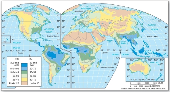 Worldwide average annual precipitation Regarding average annual precipitation,which of the following is correct?
A)The highest amounts occur throughout subtropical latitudes.
B)The drier regions are associated with the eastern portions of major landmasses.
C)The precipitation tends to increase with latitude toward the poles.
D)The highest average values occur along the equator.
E)Precipitation values tend to be greatest in central Australia.
سؤال
سؤال
سؤال
سؤال
 World climate classification Which of the following lists the correct,generalized sequence of climates from the equator to the poles?
A)Tropical → Dry → Mesothermal → Microthermal → Highland
B)Tropical → Mesothermal → Dry → Microthermal → Polar
C)Tropical → Dry → Mesothermal → Microthermal → Polar
D)Polar → Microthermal → Dry → Mesothermal → Tropical
E)Dry → Tropical → Mesothermal → Microthermal → Polar
سؤال

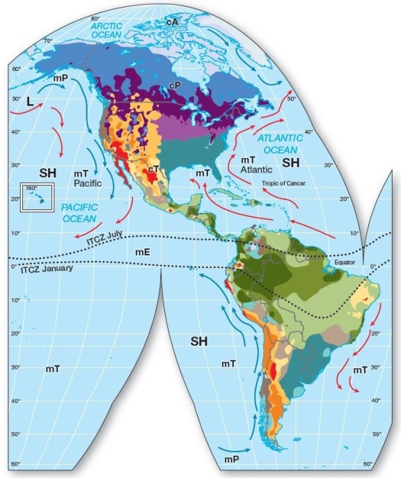
 World Climate Classification Which air mass appears to predominately influence the humid subtropical region?
A)maritime polar (mP)
B)maritime tropical (mT)
C)continental tropical (cT)
D)continental polar (cP)
E)maritime equatorial (mE)
سؤال
سؤال
سؤال
سؤال
سؤال
سؤال
سؤال
سؤال
سؤال
سؤال
سؤال
سؤال
سؤال
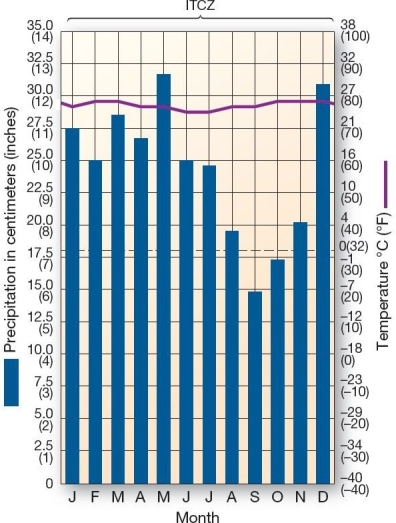
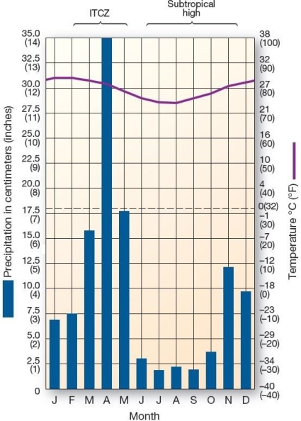
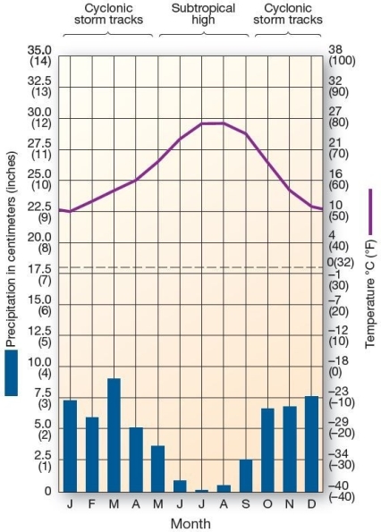
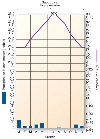
 This climograph is characteristic of which climate type?
A)humid subtropical hot-summer
B)marine west coast
C)humid subtropical winter-dry
D)Mediterranean
E)tropical monsoon
سؤال
سؤال
سؤال
سؤال
سؤال
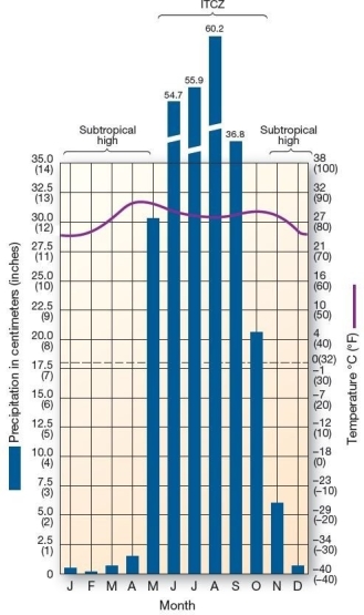
 This climograph is characteristic of which climate type?
A)Mediterranean
B)tropical rain forest
C)tropical savanna
D)marine west coast
E)polar
سؤال
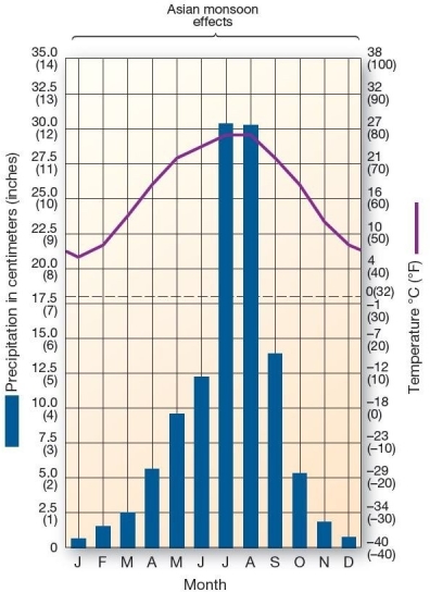
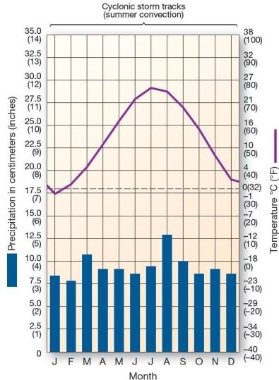
 This climograph is characteristic of which climate type?
A)highland
B)tropical rain forest
C)subtropical humid
D)midlatitude cold desert
E)tropical savanna
سؤال
سؤال
سؤال
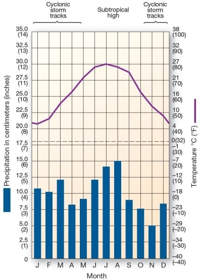
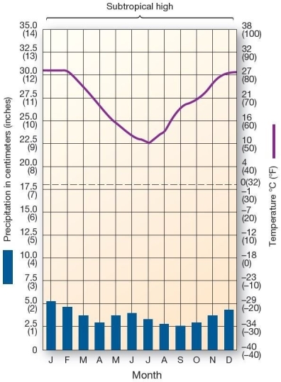
 This climograph is characteristic of which climate type?
A)Mediterranean
B)tropical monsoon
C)highland
D)humid subtropical winter-dry
E)semi-arid steppe
سؤال
سؤال
 This climograph is characteristic of which climate type?
A)humid subtropical winter-dry
B)tropical savanna
C)humid continental mild-summer
D)midlatitude cold desert
E)Mediterranean
سؤال
سؤال
 This climograph is characteristic of which climate type?
A)highland
B)tropical savanna
C)humid subtropical hot-summer
D)midlatitude cold desert
E)Mediterranean
سؤال
سؤال
سؤال
سؤال
سؤال
سؤال
سؤال
سؤال
 This climograph is characteristic of which climate type?
A)highland
B)tropical monsoon
C)humid subtropical winter-dry
D)Mediterranean
E)marine west coast
سؤال
سؤال
سؤال
سؤال
سؤال
سؤال
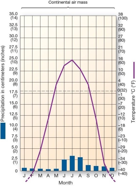
 This climograph is characteristic of which climate type?
A)humid continental hot-summer
B)tundra
C)subtropical hot desert
D)Mediterranean
E)marine west coast
سؤال
سؤال
سؤال
سؤال
سؤال
سؤال
 This climograph is characteristic of which climate type?
A)tropical rain forest
B)subarctic cold-winter
C)humid subtropical winter-dry
D)marine west coast
E)Mediterranean
سؤال
سؤال
سؤال
سؤال
سؤال
سؤال
سؤال
سؤال
سؤال
سؤال
سؤال
 This climograph is characteristic of which climate type?
A)tropical savanna
B)marine west coast
C)Mediterranean
D)subtropical hot steppe
E)highland
سؤال
سؤال
سؤال
سؤال
سؤال
سؤال
سؤال
سؤال
سؤال
 This climograph is characteristic of which climate type?
A)tropical rain forest
B)subtropical hot desert
C)humid subtropical hot-summer
D)marine west coast
E)microthermal
سؤال

فتح الحزمة
قم بالتسجيل لفتح البطاقات في هذه المجموعة!
Unlock Deck
Unlock Deck
1/77
العب
ملء الشاشة (f)
Deck 9: Earth’s Climatic Regions
1
World temperature patterns are primarily controlled by the following control except
A)latitude.
B)elevation.
C)continentality.
D)urban heat islands.
E)land-water heating differences
A)latitude.
B)elevation.
C)continentality.
D)urban heat islands.
E)land-water heating differences
D
2
A climate classification based on temperature and precipitation is a(n)classification.
A)empirical
B)genetic
C)combined
D)conjectural
E)theoretical
A)empirical
B)genetic
C)combined
D)conjectural
E)theoretical
B
3
Global circulation patterns of winds and ocean currents,which drive weather systems and,ultimately,climate patterns are created by
A)the Coriolis force.
B)frictional force caused by the Earth's spinning on its axis.
C)latitudinal energy imbalance between tropical and polar regions.
D)the differential heating properties of land and water.
E)differential cloud cover over Earth's surface.
A)the Coriolis force.
B)frictional force caused by the Earth's spinning on its axis.
C)latitudinal energy imbalance between tropical and polar regions.
D)the differential heating properties of land and water.
E)differential cloud cover over Earth's surface.
C
4
The two principal climate components are
A)temperature and pressure.
B)temperature and precipitation.
C)precipitation and pressure.
D)pressure and wind speed.
E)wind speed and precipitation
A)temperature and pressure.
B)temperature and precipitation.
C)precipitation and pressure.
D)pressure and wind speed.
E)wind speed and precipitation
فتح الحزمة
افتح القفل للوصول البطاقات البالغ عددها 77 في هذه المجموعة.
فتح الحزمة
k this deck
5
Worldwide average annual precipitation Regarding average annual precipitation,which of the following is correct?A)The highest amounts occur throughout subtropical latitudes.
B)The drier regions are associated with the eastern portions of major landmasses.
C)The precipitation tends to increase with latitude toward the poles.
D)The highest average values occur along the equator.
E)Precipitation values tend to be greatest in central Australia.
فتح الحزمة
افتح القفل للوصول البطاقات البالغ عددها 77 في هذه المجموعة.
فتح الحزمة
k this deck
6
The boundaries of the Köppen system (as well as other climate classification systems)are
A)very abrupt corresponding to air mass interaction.
B)abrupt,but variable throughout the year,migrating with high and low pressure cells.
C)transitions zones of gradual change.
D)determined by latitude and are,therefore,only estimates.
E)determined by longitude and are,therefore,only estimates.
A)very abrupt corresponding to air mass interaction.
B)abrupt,but variable throughout the year,migrating with high and low pressure cells.
C)transitions zones of gradual change.
D)determined by latitude and are,therefore,only estimates.
E)determined by longitude and are,therefore,only estimates.
فتح الحزمة
افتح القفل للوصول البطاقات البالغ عددها 77 في هذه المجموعة.
فتح الحزمة
k this deck
7
Insolation,the energy input for the climate system,is largely determined by
A)latitude.
B)altitude.
C)location of high pressure cells.
D)upper atmospheric circulation.
E)local and regional winds.
A)latitude.
B)altitude.
C)location of high pressure cells.
D)upper atmospheric circulation.
E)local and regional winds.
فتح الحزمة
افتح القفل للوصول البطاقات البالغ عددها 77 في هذه المجموعة.
فتح الحزمة
k this deck
8
Climate is
A)the weather of a region.
B)the short-term condition of the atmosphere.
C)the long-term atmospheric condition-including extremes that may occur.
D)a reference to temperature patterns only.
E)the average precipitation an area receives in a month.
A)the weather of a region.
B)the short-term condition of the atmosphere.
C)the long-term atmospheric condition-including extremes that may occur.
D)a reference to temperature patterns only.
E)the average precipitation an area receives in a month.
فتح الحزمة
افتح القفل للوصول البطاقات البالغ عددها 77 في هذه المجموعة.
فتح الحزمة
k this deck
9
World climate classification Which of the following lists the correct,generalized sequence of climates from the equator to the poles?A)Tropical → Dry → Mesothermal → Microthermal → Highland
B)Tropical → Mesothermal → Dry → Microthermal → Polar
C)Tropical → Dry → Mesothermal → Microthermal → Polar
D)Polar → Microthermal → Dry → Mesothermal → Tropical
E)Dry → Tropical → Mesothermal → Microthermal → Polar
فتح الحزمة
افتح القفل للوصول البطاقات البالغ عددها 77 في هذه المجموعة.
فتح الحزمة
k this deck
10
World Climate Classification Which air mass appears to predominately influence the humid subtropical region?A)maritime polar (mP)
B)maritime tropical (mT)
C)continental tropical (cT)
D)continental polar (cP)
E)maritime equatorial (mE)
فتح الحزمة
افتح القفل للوصول البطاقات البالغ عددها 77 في هذه المجموعة.
فتح الحزمة
k this deck
11
In terms of total land and ocean area,which of the following climate classifications is the most extensive at 36% of Earth's surface?
A)tropical climates
B)dry climates
C)mesothermal climates
D)microthermal climates
E)polar climates
A)tropical climates
B)dry climates
C)mesothermal climates
D)microthermal climates
E)polar climates
فتح الحزمة
افتح القفل للوصول البطاقات البالغ عددها 77 في هذه المجموعة.
فتح الحزمة
k this deck
12
Major ecosystems determined largely by climatic regions and classified largely based on predominant vegetation are called
A)associations.
B)zoogeographic regions.
C)biomes.
D)climate zones.
E)ecotones.
A)associations.
B)zoogeographic regions.
C)biomes.
D)climate zones.
E)ecotones.
فتح الحزمة
افتح القفل للوصول البطاقات البالغ عددها 77 في هذه المجموعة.
فتح الحزمة
k this deck
13
The tropical rain forest climate receives most of its rainfall as a result of
A)frontal uplift,only.
B)orographic uplift,only.
C)convectional uplift,only.
D)both convection and frontal uplift.
E)both orographic and frontal uplift.
A)frontal uplift,only.
B)orographic uplift,only.
C)convectional uplift,only.
D)both convection and frontal uplift.
E)both orographic and frontal uplift.
فتح الحزمة
افتح القفل للوصول البطاقات البالغ عددها 77 في هذه المجموعة.
فتح الحزمة
k this deck
14
Which of the following best describes the difference between weather and climate?
A)Weather is the collective pattern of atmospheric conditions in a given region over long periods of time,whereas climate is the atmospheric conditions at a given time and place.
B)Climate is the collective pattern of atmospheric conditions in a given region over long periods of time,whereas climate is the atmospheric conditions at a given time and place.
C)Weather refers specifically to the temperature of a given place at a given time,whereas climate refers to temperature,humidity,pressure,and wind conditions of a given place at a given time.
D)Climate refers specifically to the temperature of a given place at a given time,whereas weather refers to temperature,humidity,pressure,and wind conditions of a given place at a given time.
E)Weather and climate are essentially the same thing.
فتح الحزمة
افتح القفل للوصول البطاقات البالغ عددها 77 في هذه المجموعة.
فتح الحزمة
k this deck
15
Which of the following is not an element of weather and climate?
A)insolation
B)temperature
C)atmospheric moisture
D)air pressure
E)hourly winds speed and direction
A)insolation
B)temperature
C)atmospheric moisture
D)air pressure
E)hourly winds speed and direction
فتح الحزمة
افتح القفل للوصول البطاقات البالغ عددها 77 في هذه المجموعة.
فتح الحزمة
k this deck
16
Which of the following is not a characteristic of tropical climates?
A)short,relatively mild,winters
B)consistent day lengths
C)unstable air masses
D)warm ocean temperatures
E)influence of the ITCZ
A)short,relatively mild,winters
B)consistent day lengths
C)unstable air masses
D)warm ocean temperatures
E)influence of the ITCZ
فتح الحزمة
افتح القفل للوصول البطاقات البالغ عددها 77 في هذه المجموعة.
فتح الحزمة
k this deck
17
An area defined by characteristic,long-term weather patterns is called
A)a biome.
B)an average weather place.
C)an ecosystem.
D)a climatic region.
E)a Humboldt Zone.
A)a biome.
B)an average weather place.
C)an ecosystem.
D)a climatic region.
E)a Humboldt Zone.
فتح الحزمة
افتح القفل للوصول البطاقات البالغ عددها 77 في هذه المجموعة.
فتح الحزمة
k this deck
18
The study of the climate and its variability,including long-term weather patterns over time and space and the controls thereof is
A)climatology.
B)meteorology.
C)weatherology.
D)weather science.
E)paleontology.
A)climatology.
B)meteorology.
C)weatherology.
D)weather science.
E)paleontology.
فتح الحزمة
افتح القفل للوصول البطاقات البالغ عددها 77 في هذه المجموعة.
فتح الحزمة
k this deck
19
Tropical climates are typically located
A)straddling the equator between 20° N/S.
B)all areas of the Earth influenced by a subtropical high pressure system.
C)primarily in areas associated with cold ocean currents.
D)higher latitudes influenced by continental tropical air masses.
E)almost exclusively at high altitudes due to closer proximity to the sun.
فتح الحزمة
افتح القفل للوصول البطاقات البالغ عددها 77 في هذه المجموعة.
فتح الحزمة
k this deck
20
At low latitudes,the only interruption to tropical rainforest climates results from
A)high pressure areas forming deserts.
B)topographic features creating a rain shadow.
C)cP air masses bring cool,stable air to the region.
D)coastal upwelling and a strong thermocline.
E)high elevations with highland climates.
A)high pressure areas forming deserts.
B)topographic features creating a rain shadow.
C)cP air masses bring cool,stable air to the region.
D)coastal upwelling and a strong thermocline.
E)high elevations with highland climates.
فتح الحزمة
افتح القفل للوصول البطاقات البالغ عددها 77 في هذه المجموعة.
فتح الحزمة
k this deck
21
Which of the following characterizes a tropical savanna climate?
A)It experiences a summer wet season,and is dominated by the ITCZ for nearly 12 months of the year.
B)The sun's direct rays are overhead (subsolar point)are overhead twice each year.
C)All months receive precipitation in excess of 6 cm (2.4 in. ).
D)Its annual temperature variability is less than that of the tropical rain forest.
E)It is dominated by the ITCZ for nearly 12 months a year.
فتح الحزمة
افتح القفل للوصول البطاقات البالغ عددها 77 في هذه المجموعة.
فتح الحزمة
k this deck
22
Which of the following is not true of marine west-coast climates?
A)They are dominated by mP air masses.
B)The air masses in this region are unstable.
C)These climates experience very cold winters due to high latitude (about 45° to 55° north).
D)Weather systems forming along the polar front and maritime polar air masses move into the region throughout the year.
E)Coastal fog is part of the moderating marine influence.
فتح الحزمة
افتح القفل للوصول البطاقات البالغ عددها 77 في هذه المجموعة.
فتح الحزمة
k this deck
23
This climograph is characteristic of which climate type?A)humid subtropical hot-summer
B)marine west coast
C)humid subtropical winter-dry
D)Mediterranean
E)tropical monsoon
فتح الحزمة
افتح القفل للوصول البطاقات البالغ عددها 77 في هذه المجموعة.
فتح الحزمة
k this deck
24
More than half of the world's population resides within the
A)Tropical climates.
B)Desert climates.
C)Mesothermal climates.
D)Microthermal climates.
E)Highland climates.
A)Tropical climates.
B)Desert climates.
C)Mesothermal climates.
D)Microthermal climates.
E)Highland climates.
فتح الحزمة
افتح القفل للوصول البطاقات البالغ عددها 77 في هذه المجموعة.
فتح الحزمة
k this deck
25
Mesothermal climates
A)are essentially seasonless.
B)occupy more land and sea surface area than any other climate region.
C)have a high degree of air mass interaction.
D)are sparsely populated by humans.
E)have very little seasonal variability.
A)are essentially seasonless.
B)occupy more land and sea surface area than any other climate region.
C)have a high degree of air mass interaction.
D)are sparsely populated by humans.
E)have very little seasonal variability.
فتح الحزمة
افتح القفل للوصول البطاقات البالغ عددها 77 في هذه المجموعة.
فتح الحزمة
k this deck
26
Which of the following is false regarding the tropical monsoon climate?
A)It is located along coastal areas.
B)The transition from wet to dry conditions is the result of the shifting of the ITCZ.
C)The wind direction shifts from one time of the year to the next.
D)The summer (high Sun season)is the driest time of the year.
E)It occurs in areas with seasonal variations in precipitation.
فتح الحزمة
افتح القفل للوصول البطاقات البالغ عددها 77 في هذه المجموعة.
فتح الحزمة
k this deck
27
The dry season in the tropical monsoon climate occurs when
A)the Hadley cells reverse.
B)the ITCZ has moves away from the region.
C)a continental polar air mass influences the region.
D)cold ocean currents shift into the region.
E)the northeast trade winds reverse direction during late winter.
A)the Hadley cells reverse.
B)the ITCZ has moves away from the region.
C)a continental polar air mass influences the region.
D)cold ocean currents shift into the region.
E)the northeast trade winds reverse direction during late winter.
فتح الحزمة
افتح القفل للوصول البطاقات البالغ عددها 77 في هذه المجموعة.
فتح الحزمة
k this deck
28
This climograph is characteristic of which climate type?A)Mediterranean
B)tropical rain forest
C)tropical savanna
D)marine west coast
E)polar
فتح الحزمة
افتح القفل للوصول البطاقات البالغ عددها 77 في هذه المجموعة.
فتح الحزمة
k this deck
29
This climograph is characteristic of which climate type?A)highland
B)tropical rain forest
C)subtropical humid
D)midlatitude cold desert
E)tropical savanna
فتح الحزمة
افتح القفل للوصول البطاقات البالغ عددها 77 في هذه المجموعة.
فتح الحزمة
k this deck
30
Marine west coast climates are dominated by what air masses?
A)continental polar (cP)
B)maritime tropical (mT)
C)continental tropical (cT)
D)continental Arctic (cA)
E)maritime polar (mP)
A)continental polar (cP)
B)maritime tropical (mT)
C)continental tropical (cT)
D)continental Arctic (cA)
E)maritime polar (mP)
فتح الحزمة
افتح القفل للوصول البطاقات البالغ عددها 77 في هذه المجموعة.
فتح الحزمة
k this deck
31
The wet season of the tropical monsoon climate of SE Asia occurs during the season of Sun due to the presence of the _ over the continent.(low Sun = "winter" and high Sun = "summer")
A)low;subtropical high
B)low;ITCZ
C)high;subtropical high
D)high;ITCZ
E)low;Hadley cells
A)low;subtropical high
B)low;ITCZ
C)high;subtropical high
D)high;ITCZ
E)low;Hadley cells
فتح الحزمة
افتح القفل للوصول البطاقات البالغ عددها 77 في هذه المجموعة.
فتح الحزمة
k this deck
32
This climograph is characteristic of which climate type?A)Mediterranean
B)tropical monsoon
C)highland
D)humid subtropical winter-dry
E)semi-arid steppe
فتح الحزمة
افتح القفل للوصول البطاقات البالغ عددها 77 في هذه المجموعة.
فتح الحزمة
k this deck
33
Humid subtropical hot-summer climates receive precipitation during the summer and precipitation in the winter.
A)convectional;frontal
B)frontal;convectional
C)orographic;frontal
D)frontal;orographic
E)convectional;orographic
A)convectional;frontal
B)frontal;convectional
C)orographic;frontal
D)frontal;orographic
E)convectional;orographic
فتح الحزمة
افتح القفل للوصول البطاقات البالغ عددها 77 في هذه المجموعة.
فتح الحزمة
k this deck
34
This climograph is characteristic of which climate type?A)humid subtropical winter-dry
B)tropical savanna
C)humid continental mild-summer
D)midlatitude cold desert
E)Mediterranean
فتح الحزمة
افتح القفل للوصول البطاقات البالغ عددها 77 في هذه المجموعة.
فتح الحزمة
k this deck
35
is a mesothermal climate with a long,hot,dry summer.
A)Tropical savanna
B)Semiarid steppe
C)Mediterranean
D)Humid subtropical hot-summer
E)Humid continental hot-summer
A)Tropical savanna
B)Semiarid steppe
C)Mediterranean
D)Humid subtropical hot-summer
E)Humid continental hot-summer
فتح الحزمة
افتح القفل للوصول البطاقات البالغ عددها 77 في هذه المجموعة.
فتح الحزمة
k this deck
36
This climograph is characteristic of which climate type?A)highland
B)tropical savanna
C)humid subtropical hot-summer
D)midlatitude cold desert
E)Mediterranean
فتح الحزمة
افتح القفل للوصول البطاقات البالغ عددها 77 في هذه المجموعة.
فتح الحزمة
k this deck
37
Which of the following is false regarding the Mediterranean classification?
A)Summers are hot.
B)Seventy percent of the precipitation occurs in the winter months.
C)Summers are influenced by shifting subtropical high cells.
D)The bulk of precipitation occurs in the summer months.
E)Cool offshore ocean currents produce stability in the overlying air masses.
A)Summers are hot.
B)Seventy percent of the precipitation occurs in the winter months.
C)Summers are influenced by shifting subtropical high cells.
D)The bulk of precipitation occurs in the summer months.
E)Cool offshore ocean currents produce stability in the overlying air masses.
فتح الحزمة
افتح القفل للوصول البطاقات البالغ عددها 77 في هذه المجموعة.
فتح الحزمة
k this deck
38
Which is true of humid subtropical winter-dry climates?
A)The winter dry season is related to the seasonal pulse of the monsoons.
B)They have cold ocean currents offshore.
C)Though rain falls in every season,spring receives 5 times more rainfall than autumn.
D)They extend poleward from adjacent tropical rain forest climates.
E)It is sparsely populated.
A)The winter dry season is related to the seasonal pulse of the monsoons.
B)They have cold ocean currents offshore.
C)Though rain falls in every season,spring receives 5 times more rainfall than autumn.
D)They extend poleward from adjacent tropical rain forest climates.
E)It is sparsely populated.
فتح الحزمة
افتح القفل للوصول البطاقات البالغ عددها 77 في هذه المجموعة.
فتح الحزمة
k this deck
39
Vegetation in the tropical savanna is
A)lush (thick and green year-round).
B)dominated by grassland with scattered trees.
C)mixed deciduous and evergreen forests.
D)desert-like succulents.
E)broadleaf evergreen forests.
A)lush (thick and green year-round).
B)dominated by grassland with scattered trees.
C)mixed deciduous and evergreen forests.
D)desert-like succulents.
E)broadleaf evergreen forests.
فتح الحزمة
افتح القفل للوصول البطاقات البالغ عددها 77 في هذه المجموعة.
فتح الحزمة
k this deck
40
The tropical savanna climate has
A)the ITCZ in summer and the subtropical high in winter.
B)the polar front in winter and the subtropical high in summer.
C)the ITCZ all year-round.
D)the polar front all year-round.
E)the subtropical high in the summer and the ITCZ in the winter.
A)the ITCZ in summer and the subtropical high in winter.
B)the polar front in winter and the subtropical high in summer.
C)the ITCZ all year-round.
D)the polar front all year-round.
E)the subtropical high in the summer and the ITCZ in the winter.
فتح الحزمة
افتح القفل للوصول البطاقات البالغ عددها 77 في هذه المجموعة.
فتح الحزمة
k this deck
41
Which of the following is true of microthermal climates?
A)They have a small seasonal temperature range,hence the term microthermal.
B)Because of the latitude at which they occur,these climates occupy the largest land area of any climate.
C)In the Southern Hemisphere,these climates develop only in highland regions.
D)All of the subtypes of this climate have a uniform annual precipitation regime.
E)Diurnal differences are limited throughout the year.
فتح الحزمة
افتح القفل للوصول البطاقات البالغ عددها 77 في هذه المجموعة.
فتح الحزمة
k this deck
42
Dry climates are divided into two types according to moisture.These are
A)deserts and steppe.
B)deserts and tundra.
C)steppe and chaparral.
D)chaparral and tundra.
E)chaparral and selva.
A)deserts and steppe.
B)deserts and tundra.
C)steppe and chaparral.
D)chaparral and tundra.
E)chaparral and selva.
فتح الحزمة
افتح القفل للوصول البطاقات البالغ عددها 77 في هذه المجموعة.
فتح الحزمة
k this deck
43
Which of the following is true regarding humid continental hot-summer and humid continental mild-summer climates?
A)Humid continental mild-summer climates are located further equatorward than humid continental hot-summer climates.
B)Overall,humid continental mild-summer climates receive more precipitation than humid continental hot-summer.
C)Agriculture is not feasible in humid continental mild-summer climates due to the cooler weather,whereas it is very important in humid continental hot-summer climates.
D)Snowfall is notably heavier in humid continental mild-summer climates than in humid continental hot-summer climates and plays an important role in soil moisture recharge.
E)The humid continental hot-summer and mild-summer climates are influenced by a single air mass year-round.
فتح الحزمة
افتح القفل للوصول البطاقات البالغ عددها 77 في هذه المجموعة.
فتح الحزمة
k this deck
44
This climograph is characteristic of which climate type?A)highland
B)tropical monsoon
C)humid subtropical winter-dry
D)Mediterranean
E)marine west coast
فتح الحزمة
افتح القفل للوصول البطاقات البالغ عددها 77 في هذه المجموعة.
فتح الحزمة
k this deck
45
Which of the following is not a causal element of microthermal climates?
A)increasing seasonality
B)latitudinal;effects on temperature
C)very limited continentality
D)cyclonic activity
E)large diurnal and annual temperature ranges
A)increasing seasonality
B)latitudinal;effects on temperature
C)very limited continentality
D)cyclonic activity
E)large diurnal and annual temperature ranges
فتح الحزمة
افتح القفل للوصول البطاقات البالغ عددها 77 في هذه المجموعة.
فتح الحزمة
k this deck
46
Areas within tundra climates with a strong maritime influence are called climates.
A)maritime tundra
B)ice cap
C)highland
D)ice sheet
E)polar marine
A)maritime tundra
B)ice cap
C)highland
D)ice sheet
E)polar marine
فتح الحزمة
افتح القفل للوصول البطاقات البالغ عددها 77 في هذه المجموعة.
فتح الحزمة
k this deck
47
Which air masses influence the humid continental hot-summer climates in North America?
A)continental polar (cP)and maritime tropical (mT),especially in winter
B)continental polar (cP)year-round
C)continental polar (cP)and continental tropical (cT),especially in summer
D)continental polar (cP)in summer and continental Arctic (cA)in winter.
E)continental Arctic (cA)year-round
A)continental polar (cP)and maritime tropical (mT),especially in winter
B)continental polar (cP)year-round
C)continental polar (cP)and continental tropical (cT),especially in summer
D)continental polar (cP)in summer and continental Arctic (cA)in winter.
E)continental Arctic (cA)year-round
فتح الحزمة
افتح القفل للوصول البطاقات البالغ عددها 77 في هذه المجموعة.
فتح الحزمة
k this deck
48
Which climate is characterized by the largest change in monthly average temperatures;i.e. ,the greatest change in temperatures from one month to the next?
A)subarctic cold-winter
B)tundra
C)marine west coast
D)dry-midlatitude
E)Mediterranean
A)subarctic cold-winter
B)tundra
C)marine west coast
D)dry-midlatitude
E)Mediterranean
فتح الحزمة
افتح القفل للوصول البطاقات البالغ عددها 77 في هذه المجموعة.
فتح الحزمة
k this deck
49
Which of the following is a causal element of polar and highland climates?
A)extremes of daylength between summer and winter
B)high precipitation,primarily in the form of snow
C)low surface albedo due to ground cover
D)high sun altitude during the summer months
E)small differences of day length between winter and summer
A)extremes of daylength between summer and winter
B)high precipitation,primarily in the form of snow
C)low surface albedo due to ground cover
D)high sun altitude during the summer months
E)small differences of day length between winter and summer
فتح الحزمة
افتح القفل للوصول البطاقات البالغ عددها 77 في هذه المجموعة.
فتح الحزمة
k this deck
50
This climograph is characteristic of which climate type?A)humid continental hot-summer
B)tundra
C)subtropical hot desert
D)Mediterranean
E)marine west coast
فتح الحزمة
افتح القفل للوصول البطاقات البالغ عددها 77 في هذه المجموعة.
فتح الحزمة
k this deck
51
Which of the following is incorrect regarding ice-sheet climates?
A)The climate is dominated by dry,frigid air masses.
B)There is very little precipitation.
C)The only month with an average temperature above freezing corresponds to the summer solstice (June in the Northern Hemisphere,December in the Southern Hemisphere).
D)There are vast expanses that never warm above freezing.
E)The area of the North Pole is a sea covered by ice rather than an ice sheet.
فتح الحزمة
افتح القفل للوصول البطاقات البالغ عددها 77 في هذه المجموعة.
فتح الحزمة
k this deck
52
Why might one find tundra,glacier,and polar conditions at low latitudes?
A)The cooling effect of altitude can produce these features.
B)Cold ocean currents off the west coast of continents produce exceptionally cold conditions at low latitudes.
C)High albedo due to some land cover types prevent the absorption of insolation.
D)The high variability of day length and low sun angle create cold conditions at low latitude.
E)These are anthropogenic features that have resulted from deforestation and subsequent shifts in climate systems.
فتح الحزمة
افتح القفل للوصول البطاقات البالغ عددها 77 في هذه المجموعة.
فتح الحزمة
k this deck
53
Which of the following is not true of the subarctic climate regions of Canada and Asia?
A)Permafrost occurs here.
B)Broadleaf deciduous trees,such as maple and sweetgum,dominate the area.
C)Precipitation is low,but so is potential evapotranspiration.
D)This climate zone constitutes the maximum poleward extent of forests.
E)This climatic zone experiences exceptionally large annual temperature ranges.
فتح الحزمة
افتح القفل للوصول البطاقات البالغ عددها 77 في هذه المجموعة.
فتح الحزمة
k this deck
54
Which of the following is incorrect regarding tundra climates?
A)Spruce,fir and larch trees survive in this climate zone.
B)There is no true summer in this region.
C)Summer temperatures are never higher than 10°C (50°F).
D)The land is under continuous snow cover from 8 to 10 months.
E)Tundra climates occur primarily in the Northern Hemisphere.
A)Spruce,fir and larch trees survive in this climate zone.
B)There is no true summer in this region.
C)Summer temperatures are never higher than 10°C (50°F).
D)The land is under continuous snow cover from 8 to 10 months.
E)Tundra climates occur primarily in the Northern Hemisphere.
فتح الحزمة
افتح القفل للوصول البطاقات البالغ عددها 77 في هذه المجموعة.
فتح الحزمة
k this deck
55
Annual temperature ranges near South Georgia Island are low despite their high latitude because
A)the climate is dominated by dry,frigid air masses year-round.
B)they are influenced by maritime environments.
C)higher than average precipitation for the climate type mitigates against the extreme cold weather.
D)the island is oriented on the sunward side of a large topographic feature.
E)high elevation mitigates against the extreme cold events that otherwise occur at these latitudes.
فتح الحزمة
افتح القفل للوصول البطاقات البالغ عددها 77 في هذه المجموعة.
فتح الحزمة
k this deck
56
This climograph is characteristic of which climate type?A)tropical rain forest
B)subarctic cold-winter
C)humid subtropical winter-dry
D)marine west coast
E)Mediterranean
فتح الحزمة
افتح القفل للوصول البطاقات البالغ عددها 77 في هذه المجموعة.
فتح الحزمة
k this deck
57
Which type of vegetation is common in the Mediterranean climate?
A)taiga
B)chaparral
C)rain forest
D)boreal forest
E)selva
A)taiga
B)chaparral
C)rain forest
D)boreal forest
E)selva
فتح الحزمة
افتح القفل للوصول البطاقات البالغ عددها 77 في هذه المجموعة.
فتح الحزمة
k this deck
58
climates occupy the most extensive area of land on Earth.
A)Polar
B)Dry
C)Mesothermal
D)Tropical
E)Microthermal
A)Polar
B)Dry
C)Mesothermal
D)Tropical
E)Microthermal
فتح الحزمة
افتح القفل للوصول البطاقات البالغ عددها 77 في هذه المجموعة.
فتح الحزمة
k this deck
59
Mediterranean dry-summer climates
A)experience dry conditions in summer due to the subtropical high overhead.
B)experience wet conditions in winter due to the ITCZ overhead.
C)are bordered poleward by steppe climates.
D)experience wet conditions in summer due to the ITCZ overhead.
E)experience wet conditions in the summer due to the subtropical high overhead.
فتح الحزمة
افتح القفل للوصول البطاقات البالغ عددها 77 في هذه المجموعة.
فتح الحزمة
k this deck
60
Los Angeles,located in a Mediterranean climate zone,is kept during the summer because of the presence of .
A)dry;mountains along the western side of the city
B)dry;the cold California current off the coast
C)wet;mountains along the western side of the city
D)wet;the warm California current off the coast
E)dry;presence of the ITCZ.
A)dry;mountains along the western side of the city
B)dry;the cold California current off the coast
C)wet;mountains along the western side of the city
D)wet;the warm California current off the coast
E)dry;presence of the ITCZ.
فتح الحزمة
افتح القفل للوصول البطاقات البالغ عددها 77 في هذه المجموعة.
فتح الحزمة
k this deck
61
Which of the following is not true of tropical and subtropical hot desert climates?
A)In most years,they do not receive any precipitation.
B)Annual average temperatures are above 18°C (64.4°F).
C)They are generally found on the western side of continents.
D)They are under the influence of subtropical high pressure systems.
E)In some areas,such as the Sahel,desert conditions are expanding.
فتح الحزمة
افتح القفل للوصول البطاقات البالغ عددها 77 في هذه المجموعة.
فتح الحزمة
k this deck
62
In order to maintain optimal cacao growing conditions as global temperatures rise,
A)more moisture resistant varieties are being developed.
B)producers are clearing more land for planting.
C)production is occurring at lower latitudes.
D)seeds are being stored in anticipation of global chocolate shortages.
E)cacao cultivation will need to move uphill into more limited terrain.
A)more moisture resistant varieties are being developed.
B)producers are clearing more land for planting.
C)production is occurring at lower latitudes.
D)seeds are being stored in anticipation of global chocolate shortages.
E)cacao cultivation will need to move uphill into more limited terrain.
فتح الحزمة
افتح القفل للوصول البطاقات البالغ عددها 77 في هذه المجموعة.
فتح الحزمة
k this deck
63
Geosystems list several potential outcomes from shifting climatic zones,such as increased ranges of dengue fever carrying mosquitoes and increased drought in subtropical regions.What are some other possible adverse effects associated with climate change and shifting climate zones? Are there any potential benefits?
فتح الحزمة
افتح القفل للوصول البطاقات البالغ عددها 77 في هذه المجموعة.
فتح الحزمة
k this deck
64
Factors that influence dry climates include all the following except
A)seasonal influence of the ITCZ.
B)dry,subsiding air associated with subtropical high pressure systems.
C)location in the rain shadow of mountains.
D)cool,stabilizing ocean currents along the western margins of continents.
E)location in continental interiors.
A)seasonal influence of the ITCZ.
B)dry,subsiding air associated with subtropical high pressure systems.
C)location in the rain shadow of mountains.
D)cool,stabilizing ocean currents along the western margins of continents.
E)location in continental interiors.
فتح الحزمة
افتح القفل للوصول البطاقات البالغ عددها 77 في هذه المجموعة.
فتح الحزمة
k this deck
65
Dengue fever,an infectious tropical disease carried by mosquitos,has
A)been nearly wiped out because of climate change related shifts in subtropical high pressure cells.
B)spread previously unaffected areas due to changes in climatic conditions.
C)never been reported in the U.S. ,but scientists fear it may arrive due to expansion of Aedes aegypti mosquitoes.
D)shifted equatorward due to desertification in the subtropics.
E)been eradicated due to the climate change induced extinction of the Aedes aegypti mosquitoes.
فتح الحزمة
افتح القفل للوصول البطاقات البالغ عددها 77 في هذه المجموعة.
فتح الحزمة
k this deck
66
What is the difference between weather and climate? Give examples of each,preferably using the area in which you live.
فتح الحزمة
افتح القفل للوصول البطاقات البالغ عددها 77 في هذه المجموعة.
فتح الحزمة
k this deck
67
This climograph is characteristic of which climate type?A)tropical savanna
B)marine west coast
C)Mediterranean
D)subtropical hot steppe
E)highland
فتح الحزمة
افتح القفل للوصول البطاقات البالغ عددها 77 في هذه المجموعة.
فتح الحزمة
k this deck
68
The two factors that determine the distribution of the four distinct dry climate regimes are
A)longitude and seasonality of monsoons.
B)latitude and the amount of moisture deficit.
C)hemisphere and proximity of cold ocean currents.
D)location of Hadley cells and location of Ferrell cells.
E)jet stream and Rossby waves.
A)longitude and seasonality of monsoons.
B)latitude and the amount of moisture deficit.
C)hemisphere and proximity of cold ocean currents.
D)location of Hadley cells and location of Ferrell cells.
E)jet stream and Rossby waves.
فتح الحزمة
افتح القفل للوصول البطاقات البالغ عددها 77 في هذه المجموعة.
فتح الحزمة
k this deck
69
The climate types discussed in Geosystems are broad scale with the various climate types covering large (relatively speaking)geographic areas.However,local conditions,the so-called microclimatology may differ from the broad generalizations.Locate the climatic regime in your city or town.Compare and contrast the characteristics of this climate to localized climate of your city or town.
فتح الحزمة
افتح القفل للوصول البطاقات البالغ عددها 77 في هذه المجموعة.
فتح الحزمة
k this deck
70
The low-latitude hot desert climates occur
A)in the tropics and subtropics.
B)only in midlatitude rainshadow positions.
C)in polar regions.
D)along the midlatitude,west coasts of continents.
E)in the midlatitudes.
A)in the tropics and subtropics.
B)only in midlatitude rainshadow positions.
C)in polar regions.
D)along the midlatitude,west coasts of continents.
E)in the midlatitudes.
فتح الحزمة
افتح القفل للوصول البطاقات البالغ عددها 77 في هذه المجموعة.
فتح الحزمة
k this deck
71
Describe the weather components that combine to produce climate of the area in which you live.
فتح الحزمة
افتح القفل للوصول البطاقات البالغ عددها 77 في هذه المجموعة.
فتح الحزمة
k this deck
72
Along the periphery of hot deserts,where shifting subtropical high pressure cells create a distinct summer-dry and winter-wet pattern,one finds
A)tropical,subtropical hot steppe climates.
B)marine west coast climates.
C)tropical monsoon climates.
D)humid subtropical hot-summer climates.
E)Mediterranean climates.
A)tropical,subtropical hot steppe climates.
B)marine west coast climates.
C)tropical monsoon climates.
D)humid subtropical hot-summer climates.
E)Mediterranean climates.
فتح الحزمة
افتح القفل للوصول البطاقات البالغ عددها 77 في هذه المجموعة.
فتح الحزمة
k this deck
73
The climate regime exemplified by Asia's Taklamakan Desert,Argentina's Patagonia,and areas of central Nevada is
A)marine west coast.
B)tropical savanna.
C)humid subtropical hot-summer.
D)subarctic cold winter.
E)midlatitude cold desert.
A)marine west coast.
B)tropical savanna.
C)humid subtropical hot-summer.
D)subarctic cold winter.
E)midlatitude cold desert.
فتح الحزمة
افتح القفل للوصول البطاقات البالغ عددها 77 في هذه المجموعة.
فتح الحزمة
k this deck
74
Which of the following is incorrect regarding climate regions and climate change?
A)Tropical climates are expanding to higher latitudes.
B)Subtropical high pressures systems and associated dry conditions are moving to higher latitudes.
C)Many areas are becoming more prone to drought.
D)The boundaries of climate regions are fairly static.
E)Climate-related changes in the ranges of disease-carrying insects affect humans.
فتح الحزمة
افتح القفل للوصول البطاقات البالغ عددها 77 في هذه المجموعة.
فتح الحزمة
k this deck
75
You have been asked to design a new climate classification system.Will it be based on causative factors (i.e. ,a genetic classification)or statistics (i.e. ,an empirical classification system),or a combination thereof? What factors will you consider in your classification?
فتح الحزمة
افتح القفل للوصول البطاقات البالغ عددها 77 في هذه المجموعة.
فتح الحزمة
k this deck
76
This climograph is characteristic of which climate type?A)tropical rain forest
B)subtropical hot desert
C)humid subtropical hot-summer
D)marine west coast
E)microthermal
فتح الحزمة
افتح القفل للوصول البطاقات البالغ عددها 77 في هذه المجموعة.
فتح الحزمة
k this deck
77
The western Great Plains of North America are characterized by a climate.
A)tropical hot desert
B)subtropical hot desert
C)midlatitude cold desert
D)midlatitude cold steppe
E)subtropical hot steppe
A)tropical hot desert
B)subtropical hot desert
C)midlatitude cold desert
D)midlatitude cold steppe
E)subtropical hot steppe
فتح الحزمة
افتح القفل للوصول البطاقات البالغ عددها 77 في هذه المجموعة.
فتح الحزمة
k this deck
فتح الحزمة
افتح القفل للوصول البطاقات البالغ عددها 77 في هذه المجموعة.


