Deck 2: ArcGIS Desktop Entry 10.5
Full screen (f)
Question
Question
Question
Question
Question
Question
Question
Question
Refer to the exhibit.  The exhibit below provides a conceptual view of a coordinate grid onto which all coordinate values snap to the grid mesh. The grid covers the extent of each dataset. An ArcGIS user is creating a new feature class, and needs to increase the numeric precision used to store the coordinate values. When modified, which of the following will increase the numeric precision used to store the coordinate values?
A) X,Y Tolerance
B) Z value
C) M Value
D) X,Y Resolution
The exhibit below provides a conceptual view of a coordinate grid onto which all coordinate values snap to the grid mesh. The grid covers the extent of each dataset. An ArcGIS user is creating a new feature class, and needs to increase the numeric precision used to store the coordinate values. When modified, which of the following will increase the numeric precision used to store the coordinate values?A) X,Y Tolerance
B) Z value
C) M Value
D) X,Y Resolution
Question
Question
Question
Question
Question
Question
Question
Question
Question
Question
Question
Question
Question
Question
Question
Question
Question
Question
Question
Question
Question
Question
Question
Question
Question
Question
Question
Question
Question
Question
Question
Question
Question
Question
Question
Question
Question
Refer to the exhibits. 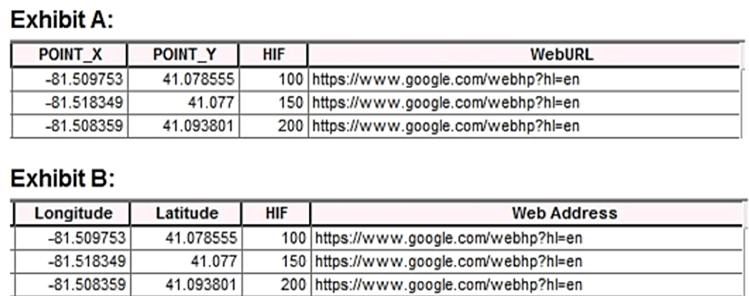 An ArcGIS user is previewing attribute tables for feature classes in ArcCatalog. The user needs to change the display of the fields from Exhibit A to Exhibit B. What should the user select after clicking the Table Options button?
A) Show Field Aliases
B) Reload Field Properties
C) Display Field Names
D) Restore Field Description
An ArcGIS user is previewing attribute tables for feature classes in ArcCatalog. The user needs to change the display of the fields from Exhibit A to Exhibit B. What should the user select after clicking the Table Options button?A) Show Field Aliases
B) Reload Field Properties
C) Display Field Names
D) Restore Field Description
Question
Question

Unlock Deck
Sign up to unlock the cards in this deck!
Unlock Deck
Unlock Deck
1/47
Play
Full screen (f)
Deck 2: ArcGIS Desktop Entry 10.5
1
What is the primary purpose of metadata?
A) To automatically populate fields when using an item for geoprocessing
B) To make an item searchable with a detailed description and relevant tags
C) To make sure an item has a descriptive name to view the file in ArcCatalog
D) To populate the Data Properties with information in addition to the default information
To make an item searchable with a detailed description and relevant tags
2
A GIS user has an address and must display the location of the address as a point on the map. The user has a general idea of where the address is located but needs a precise result How should the user efficiently perform this task in ArcMap?
A) Type the full address in the search field of the Geocoding Toolbar, and press Enter
B) Zoom in to the city, pan to the street. and use the Address Inspector on the Geocoding Toolbar
C) Open the Go To XY tool and search the full address
D) Open the Geocode Addresses tool from the Geocoding Toolbar and search the full address
Open the Go To XY tool and search the full address
3
A GIS user creates a folder connection in ArcGIS Pro. Most of the user's work is typically done with the same collection of data. The user finishes that project and creates a new ArcGIS Pro project to begin working in a new geographic area. The folder connection has disappeared. What should the user do to persist that folder connection in multiple projects?
A) Make the folder connection with relative project paths
B) Always make file geodatabase connections
C) Set ArcGIS Pro to Work Offline to preserve the folder
D) Create a project template that contains the folder connection
A) Make the folder connection with relative project paths
B) Always make file geodatabase connections
C) Set ArcGIS Pro to Work Offline to preserve the folder
D) Create a project template that contains the folder connection
Make the folder connection with relative project paths
4
An ArcMap user must determine the coordinate system of a dataset. Where is this information located?
A) Data Frame Properties > Source tab
B) Feature Class Properties > XY Coordinate System tab
C) Layer Properties > XY Coordinate System tab
D) Feature Class Properties > Source tab
A) Data Frame Properties > Source tab
B) Feature Class Properties > XY Coordinate System tab
C) Layer Properties > XY Coordinate System tab
D) Feature Class Properties > Source tab
Unlock Deck
Unlock for access to all 47 flashcards in this deck.
Unlock Deck
k this deck
5
A GIS technician needs to export multiple maps of individual county parcels. Which action should the technician take to achieve this in ArcGIS Pro?
A) Enable Map Series pages
B) Export a map at the county scale
C) Export a layout to a .pdf format
D) Export a layout with compressed vector graphics
A) Enable Map Series pages
B) Export a map at the county scale
C) Export a layout to a .pdf format
D) Export a layout with compressed vector graphics
Unlock Deck
Unlock for access to all 47 flashcards in this deck.
Unlock Deck
k this deck
6
A GIS user typically works with the same geodatabase, the same set of locators, and the same layers added to the map. What is the most efficient way to simplify new project creation?
A) Create a web map with all data > Import the map into new projects
B) Create a Project Template with all data > Open new projects from the template
C) Save all data to a folder > Add a folder connection to a new project > Add data from the folder connection
D) Save a project with all data > Begin by opening that project > Save as a new project
Unlock Deck
Unlock for access to all 47 flashcards in this deck.
Unlock Deck
k this deck
7
A city planner is working with a map that represents areas of the city that are being evaluated for new construction and moving or eliminating certain streets. The planner is using the Create Feature Class geoprocessing tool to create a feature class that represents all streets as they would exist after the improvement project is completed. Which Geometry Type should the planner select for the feature class to identify the overall changes in length to the road network?
A) Multipoint
B) Polyline
C) Polygon
D) Multipatch
A) Multipoint
B) Polyline
C) Polygon
D) Multipatch
Unlock Deck
Unlock for access to all 47 flashcards in this deck.
Unlock Deck
k this deck
8
Refer to the exhibit. The exhibit below provides a conceptual view of a coordinate grid onto which all coordinate values snap to the grid mesh. The grid covers the extent of each dataset. An ArcGIS user is creating a new feature class, and needs to increase the numeric precision used to store the coordinate values. When modified, which of the following will increase the numeric precision used to store the coordinate values?
A) X,Y Tolerance
B) Z value
C) M Value
D) X,Y Resolution
The exhibit below provides a conceptual view of a coordinate grid onto which all coordinate values snap to the grid mesh. The grid covers the extent of each dataset. An ArcGIS user is creating a new feature class, and needs to increase the numeric precision used to store the coordinate values. When modified, which of the following will increase the numeric precision used to store the coordinate values?A) X,Y Tolerance
B) Z value
C) M Value
D) X,Y Resolution
Unlock Deck
Unlock for access to all 47 flashcards in this deck.
Unlock Deck
k this deck
9
An ArcMap user needs to inspect the geometry and attribute schema properties of a file geodatabase feature class. The user does NOT want to add the feature class to a map. How should the user perform this task using the Catalog window?
A) Add or use a folder connection to the file geodatabase > Open the Item Description context menu of the data
B) Add or use a folder connection to the file geodatabase > Open the Properties context menu of the data
C) Navigate to the Conversion Tools > Export Metadata Toolset geoprocessing tool
D) Add or use a folder connection to the file geodatabase > Open the Properties context menu of the geodatabase
Unlock Deck
Unlock for access to all 47 flashcards in this deck.
Unlock Deck
k this deck
10
An ArcGIS Pro user makes a selection on a feature layer using the following expression: Suburb is Equal to Abbey Caves The user opens the attribute table and notices the expression has been entered incorrectly. The expression should have been: Suburb does Not Equal Abbey Caves How should the user efficiently apply the correct selection expression?
A) Attribute Table > Calculate
B) Geoprocessing Pane > Select By Attributes > Build the correct query > Run
C) Attribute Table > Switch
D) Geoprocessing Pane > Select By Attributes > Clear the current selection > Build the correct query > Run
A) Attribute Table > Calculate
B) Geoprocessing Pane > Select By Attributes > Build the correct query > Run
C) Attribute Table > Switch
D) Geoprocessing Pane > Select By Attributes > Clear the current selection > Build the correct query > Run
Unlock Deck
Unlock for access to all 47 flashcards in this deck.
Unlock Deck
k this deck
11
A biologist must go into the field and record locations of every site that currently has standing water with mosquito larvae. Which application should the biologist use?
A) ArcGIS Online
B) ArcGIS Pro
C) Navigator for ArcGIS
D) Collector for ArcGIS
A) ArcGIS Online
B) ArcGIS Pro
C) Navigator for ArcGIS
D) Collector for ArcGIS
Unlock Deck
Unlock for access to all 47 flashcards in this deck.
Unlock Deck
k this deck
12
An ArcGIS user is developing a series of maps for a large scale transportation project The project manager needs a single file that contains all spatial products created for the project. Which ArcGIS platform application allows the user to store multiple maps and multiple layouts in a single file?
A) ArcMap
B) ArcGIS Pro
C) ArcGIS ArcReader
D) ArcGIS Earth
A) ArcMap
B) ArcGIS Pro
C) ArcGIS ArcReader
D) ArcGIS Earth
Unlock Deck
Unlock for access to all 47 flashcards in this deck.
Unlock Deck
k this deck
13
A researcher is mapping a small national park that has an east-west orientation near the equator. Which map projection should be used for this study area?
A) Transverse Mercator
B) Albers Equal Area Conic
C) Lambert Conformal Conic
D) Polar Stereographic
A) Transverse Mercator
B) Albers Equal Area Conic
C) Lambert Conformal Conic
D) Polar Stereographic
Unlock Deck
Unlock for access to all 47 flashcards in this deck.
Unlock Deck
k this deck
14
An ArcGIS user is creating a map of a village. The user needs the map to clearly display features such as streets, trees, and businesses in the village. Which scale should the user choose for this map?
A) Large scale to cover a small area of the ground with a high level of detail
B) Small scale to cover a small area of the ground with a high level of detail
C) Large scale to cover a large area of the ground with a low level of detail
D) Small scale to cover a large area of the ground with a low level of detail
Unlock Deck
Unlock for access to all 47 flashcards in this deck.
Unlock Deck
k this deck
15
Which data format can be added as an item to ArcGIS Online?
A) File geodatabase in a folder
B) Shapefile in a zipped folder
C) XML workspace document
D) Geometric network
A) File geodatabase in a folder
B) Shapefile in a zipped folder
C) XML workspace document
D) Geometric network
Unlock Deck
Unlock for access to all 47 flashcards in this deck.
Unlock Deck
k this deck
16
An ArcGIS Pro user spends 6 months performing analysis on a project The user must send the project to the cartographer to complete the final map layouts. The cartographer does NOT have access to all data storage locations that were used for the project. Which file format allows the user to send the completed project to the cartographer?
A) .ppkx
B) .aprx
C) .pagx
D) .Ipkx
A) .ppkx
B) .aprx
C) .pagx
D) .Ipkx
Unlock Deck
Unlock for access to all 47 flashcards in this deck.
Unlock Deck
k this deck
17
An analyst has project data in the form of shapefiles What should the analyst do to import the data to a file geodatabase?
A) Run The Multipart To Singlepart geoprocessing tool
B) Upgrade the X,Y precision of the spatial reference during import
C) Create a spatial index on the shapefile prior to importing the data
D) Run The Feature Class To Feature Class geoprocessing tool
A) Run The Multipart To Singlepart geoprocessing tool
B) Upgrade the X,Y precision of the spatial reference during import
C) Create a spatial index on the shapefile prior to importing the data
D) Run The Feature Class To Feature Class geoprocessing tool
Unlock Deck
Unlock for access to all 47 flashcards in this deck.
Unlock Deck
k this deck
18
A GIS analyst is working with a large number of polygon features in a layer in ArcGIS Pro and needs to display only a subset of features but retain all records in the attribute table. How should the analyst accomplish this task?
A) Apply a display filter on the polygon layer to exclude certain features based on a SQL expression.
B) Apply a definition query on the polygon layer to exclude certain features based on a SQL expression.
C) Apply a page query on the polygon layer to exclude certain features based on a SQL expression.
Unlock Deck
Unlock for access to all 47 flashcards in this deck.
Unlock Deck
k this deck
19
A researcher is opening a new, blank ArcGIS Pro Project. Upon creating the ArcGIS Pro Project, a map is NOT visible. What should the researcher do to begin the project?
A) Insert a new basemap from the Insert tab
B) Make a folder connection to the file geodatabase
C) Insert a new map from the Insert tab
D) Insert a new layout from the Insert tab
A) Insert a new basemap from the Insert tab
B) Make a folder connection to the file geodatabase
C) Insert a new map from the Insert tab
D) Insert a new layout from the Insert tab
Unlock Deck
Unlock for access to all 47 flashcards in this deck.
Unlock Deck
k this deck
20
To leverage additional labeling properties, users can switch between Standard and Maplex labeling engines. Where is this change applied in ArcMap?
A) Labeling tab in the Layer Properties
B) Database Properties
C) Map Document Properties
D) Labeling toolbar
A) Labeling tab in the Layer Properties
B) Database Properties
C) Map Document Properties
D) Labeling toolbar
Unlock Deck
Unlock for access to all 47 flashcards in this deck.
Unlock Deck
k this deck
21
Which spatial selection method allows a user to select polygons that share at least half of their area within another, single, large polygon?
A) Intersect the source layer feature
B) Touch the boundary of the source layer feature
C) Are identical to the source layer feature
D) Have a polygon centroid in the source layer feature
A) Intersect the source layer feature
B) Touch the boundary of the source layer feature
C) Are identical to the source layer feature
D) Have a polygon centroid in the source layer feature
Unlock Deck
Unlock for access to all 47 flashcards in this deck.
Unlock Deck
k this deck
22
A GIS analyst is working in ArcGIS Pro. The analyst needs to use a Living Atlas layer from ArcGIS Online. How should the analyst find a Living Atlas layer to add to the project?
A) Make a folder connection
B) Make a database connection
C) Use the Insert tab to add a Living Atlas connection
D) Use the Portal tab in the Project Pane
A) Make a folder connection
B) Make a database connection
C) Use the Insert tab to add a Living Atlas connection
D) Use the Portal tab in the Project Pane
Unlock Deck
Unlock for access to all 47 flashcards in this deck.
Unlock Deck
k this deck
23
An ArcGIS Online user is creating a web map with hospital locations. The only data the user has is a zipped folder that contains a shapefile of hospital points. How should the user add this zipped shapefile to a new web map?
A) Add button dropdown > Add Layer From Web
B) Add button dropdown > Search for Layers
C) Add Item dropdown > Add Layer From File
D) Add button dropdown > Add Layer From File
A) Add button dropdown > Add Layer From Web
B) Add button dropdown > Search for Layers
C) Add Item dropdown > Add Layer From File
D) Add button dropdown > Add Layer From File
Unlock Deck
Unlock for access to all 47 flashcards in this deck.
Unlock Deck
k this deck
24
A zipped shapefile has been added to the map viewer using the Add > Add Layer From File Option. In ArcGIS Online, which feature layer type is the newly added item?
A) Feature Collection
B) Hosted view
C) Shapefile
D) Hosted Feature Layer
A) Feature Collection
B) Hosted view
C) Shapefile
D) Hosted Feature Layer
Unlock Deck
Unlock for access to all 47 flashcards in this deck.
Unlock Deck
k this deck
25
A GIS analyst shares the results of an analysis project with colleagues in the same organization. All colleagues do NOT have access to ArcGIS Desktop mapping software. Using a web map, users must be able to interact with the web map and identify trends and patterns discovered as a result of the analysis. Which web map layers should be the main focus of the users' interaction?
A) Web map layers
B) Reference layers
C) Basemap layers
D) Operational layers
A) Web map layers
B) Reference layers
C) Basemap layers
D) Operational layers
Unlock Deck
Unlock for access to all 47 flashcards in this deck.
Unlock Deck
k this deck
26
A GIS user is geocoding for the first time in ArcMap and needs to search for a single address. What is the first step the user should take to access geocoding functionality?
A) Open the Go To XY tool to search for the address
B) Open the Geocoding toolbox from ArcToolbox
C) Use the Customize drop-down to add the Geocoding Toolbar
D) Go to the Location search bar in the Catalog pane
A) Open the Go To XY tool to search for the address
B) Open the Geocoding toolbox from ArcToolbox
C) Use the Customize drop-down to add the Geocoding Toolbar
D) Go to the Location search bar in the Catalog pane
Unlock Deck
Unlock for access to all 47 flashcards in this deck.
Unlock Deck
k this deck
27
An ArcMap user must use Select By Attributes to select earthquake features that have a magnitude greater than 4. The MAGNITUDE field holds Float values. Which query expression should be used?
A) MAGNITUDE Is greater Than 4.0
B) MAGNITUDE > '4.0'
C) MAGNITUDE > 4.0
D) MAGNITUDE >=4.0
A) MAGNITUDE Is greater Than 4.0
B) MAGNITUDE > '4.0'
C) MAGNITUDE > 4.0
D) MAGNITUDE >=4.0
Unlock Deck
Unlock for access to all 47 flashcards in this deck.
Unlock Deck
k this deck
28
A GIS user is working with the city's public works field crew on an annual inspection of city assets. The GIS user wants to collect photos and information to evaluate the current asset condition. Which application should the user deploy to achieve this task?
A) Navigator for ArcGIS
B) Explorer for ArcGIS
C) Survey 123 for ArcGIS
D) Story Maps
A) Navigator for ArcGIS
B) Explorer for ArcGIS
C) Survey 123 for ArcGIS
D) Story Maps
Unlock Deck
Unlock for access to all 47 flashcards in this deck.
Unlock Deck
k this deck
29
An ArcGIS Pro user is working with several layers in a map that were added from feature classes in a geodatabase and then modified with custom symbology. The user copies the layers from the original map and pastes them into the Contents Pane in the second map. The user expected default symbology, but all the symbology modifications carried over. What should the user have done differently?
A) The user should have shared the layers to the web and then imported them into the second map.
B) The user should have selected Single Symbol from the Symbology dropdown in the Appearance tab on the ribbon to limit the symbology to one map.
C) The user should NOT have saved the Project before copying the layers over. The user should NOT have saved the Project before copying the layers over.
D) The user should have added the feature classes from the geodatabase into the second map.
Unlock Deck
Unlock for access to all 47 flashcards in this deck.
Unlock Deck
k this deck
30
A GIS user plans to move an ArcMap document referencing 8 GB of data to a network location to be accessed by coworkers on the same network. The user copies all data to the same network location. What should the user do first to accomplish this task as efficiently as possible?
A) Modify the map settings to store relative pathnames
B) Zip all data and send to coworkers
C) Create a folder connection to the data in the map
D) Remove some of the data from the map
A) Modify the map settings to store relative pathnames
B) Zip all data and send to coworkers
C) Create a folder connection to the data in the map
D) Remove some of the data from the map
Unlock Deck
Unlock for access to all 47 flashcards in this deck.
Unlock Deck
k this deck
31
An ArcGIS user has a raster layer of slope for an area. Which render displays the slope by grouping the cell values into categories?
A) RGB Composite
B) Stretched
C) Classified
D) Unique Values
A) RGB Composite
B) Stretched
C) Classified
D) Unique Values
Unlock Deck
Unlock for access to all 47 flashcards in this deck.
Unlock Deck
k this deck
32
A technician has a map of cell phone towers. An additional tower needs to be added in the middle of a national park and the technician has only x,y coordinates recorded for the tower's location. How should the technician locate this tower on the map?
A) Use the search field on the Portal tab of the Project pane to search for the coordinates in ArcGIS Pro.
B) Enable the Address Inspector on ArcMap's Geocoding Toolbar and use it to navigate to the x,y coordinates in the national park.
C) Open the Locate pane in ArcGIS Pro and search for the coordinates.
D) Right-click the map in the national park and select What's Here in ArcGIS Pro.
Unlock Deck
Unlock for access to all 47 flashcards in this deck.
Unlock Deck
k this deck
33
How should an ArcMap user create a file geodatabase in a previous version?
A) Catalog window > Right-click folder > Create MDB
B) ArcToolbox > Create File GDB
C) Catalog window > Right-click folder > New > Geodatabase
D) ArcToolbox > Create Version
A) Catalog window > Right-click folder > Create MDB
B) ArcToolbox > Create File GDB
C) Catalog window > Right-click folder > New > Geodatabase
D) ArcToolbox > Create Version
Unlock Deck
Unlock for access to all 47 flashcards in this deck.
Unlock Deck
k this deck
34
Which two methods can be used to create a feature class in ArcMap? (Choose two.)
A) ArcToolbox > Data Management Tools > Feature Class > Create Feature Class
B) Catalog window > Right-click a geodatabase > New > Feature Class
C) Catalog window > Right-click a folder > New > Feature Class
D) File > Add Data > Add Data > Shapefile > New Feature Class
E) Start an Edit session > Create Features window > Click Feature Template > Create Features
Unlock Deck
Unlock for access to all 47 flashcards in this deck.
Unlock Deck
k this deck
35
A user signs into an ArcGIS Online organizational account to find a web layer that can be added to a web map. Which option takes the user directly to a page that shows the organization's featured content as a series of thumbnails?
A) Map
B) Scene
C) Gallery
D) My Organization
A) Map
B) Scene
C) Gallery
D) My Organization
Unlock Deck
Unlock for access to all 47 flashcards in this deck.
Unlock Deck
k this deck
36
An ArcGIS Pro user wants to add a new 2D map to a project using an existing ArcMap map document. Which workflow should the user follow?
A) Project pane > Maps > New Map
B) Folder Connection > 3D file > Import and Open
C) Catalog window > Drag into ArcGIS Pro
D) Insert Tab > Import Map
A) Project pane > Maps > New Map
B) Folder Connection > 3D file > Import and Open
C) Catalog window > Drag into ArcGIS Pro
D) Insert Tab > Import Map
Unlock Deck
Unlock for access to all 47 flashcards in this deck.
Unlock Deck
k this deck
37
A supervisor wants a user to create a new feature class in an editing session based on an existing feature class. The supervisor also wants the user to use the Append geoprocessing tool to add the features from the original feature class to the new feature class. How should the user create a new feature class that has the same schema as the original feature class?
A) Import spatial reference from the original feature class
B) Import the fields from the original feature class
C) Ensure the X,Y Tolerance is the same as the original feature class
D) Ensure that the Z and M coordinates are the same as the original feature class
A) Import spatial reference from the original feature class
B) Import the fields from the original feature class
C) Ensure the X,Y Tolerance is the same as the original feature class
D) Ensure that the Z and M coordinates are the same as the original feature class
Unlock Deck
Unlock for access to all 47 flashcards in this deck.
Unlock Deck
k this deck
38
Which file type can be dragged and dropped from the desktop directly into the ArcGIS Online map viewer?
A) .csv
B) .gdb
C) mpk
D) shp
A) .csv
B) .gdb
C) mpk
D) shp
Unlock Deck
Unlock for access to all 47 flashcards in this deck.
Unlock Deck
k this deck
39
By default, which workspace type is automatically created by ArcGIS Pro when a new Project is created?
A) Personal Geodatabase
B) File Geodatabase
C) Enterprise Geodatabase
D) Database Connection
A) Personal Geodatabase
B) File Geodatabase
C) Enterprise Geodatabase
D) Database Connection
Unlock Deck
Unlock for access to all 47 flashcards in this deck.
Unlock Deck
k this deck
40
A GIS researcher needs to create a web map in ArcGIS Online and share it to the public. The researcher must make sure that certain features in the map do NOT show, based on the values in a certain field in the attribute table. The end user should still be able to access this features if needed. How should the researcher perform this task?
A) Set a visibility range on the layer in the web map
B) Set transparency on the layer in the web map
C) Apply a filter on the layer in the web map
D) Change the style of the layer in the web map
A) Set a visibility range on the layer in the web map
B) Set transparency on the layer in the web map
C) Apply a filter on the layer in the web map
D) Change the style of the layer in the web map
Unlock Deck
Unlock for access to all 47 flashcards in this deck.
Unlock Deck
k this deck
41
An ArcGIS Online user is working with a feature layer representing regional village locations in a study area Each village should be symbolized by using a specific color which identifies the region. How should the user change the style of the village layer to accomplish this task?
A) Show Location (Single Symbol)
B) Show a Heat Map
C) Show Types (Unique Symbols)
D) Show Multiple Attributes
A) Show Location (Single Symbol)
B) Show a Heat Map
C) Show Types (Unique Symbols)
D) Show Multiple Attributes
Unlock Deck
Unlock for access to all 47 flashcards in this deck.
Unlock Deck
k this deck
42
An analyst needs to know the distances and directions from an input polyline feature class to multiple point feature classes. Which tool should the analyst use?
A) Point Distance
B) Generate Near Table
C) Near
D) Polygon Neighbors
A) Point Distance
B) Generate Near Table
C) Near
D) Polygon Neighbors
Unlock Deck
Unlock for access to all 47 flashcards in this deck.
Unlock Deck
k this deck
43
A researcher receives a shapefile that contains field data that appears to be missing its .prj file. When the data is added as a layer to an existing map, the data aligns and displays correctly. How should the researcher generate the missing .prj file?
A) Project the shapefile
B) Import the shapefile into a geodatabase
C) Define the projection
D) Export the data from the Layer > Data > Export dialog
A) Project the shapefile
B) Import the shapefile into a geodatabase
C) Define the projection
D) Export the data from the Layer > Data > Export dialog
Unlock Deck
Unlock for access to all 47 flashcards in this deck.
Unlock Deck
k this deck
44
An ArcGIS Pro user is interested in gaining demographic insights about locations selected manually on a map The queries do NOT need to be added to the map as layers. Charts and reports are more important. How should the user access this information after connecting to ArcGIS Online?
A) Search for Esri demographic data
B) Search All Portal by keyword tags
C) Browse Living Atlas services
D) Configure Infographics
A) Search for Esri demographic data
B) Search All Portal by keyword tags
C) Browse Living Atlas services
D) Configure Infographics
Unlock Deck
Unlock for access to all 47 flashcards in this deck.
Unlock Deck
k this deck
45
Refer to the exhibits. An ArcGIS user is previewing attribute tables for feature classes in ArcCatalog. The user needs to change the display of the fields from Exhibit A to Exhibit B. What should the user select after clicking the Table Options button?
A) Show Field Aliases
B) Reload Field Properties
C) Display Field Names
D) Restore Field Description
An ArcGIS user is previewing attribute tables for feature classes in ArcCatalog. The user needs to change the display of the fields from Exhibit A to Exhibit B. What should the user select after clicking the Table Options button?A) Show Field Aliases
B) Reload Field Properties
C) Display Field Names
D) Restore Field Description
Unlock Deck
Unlock for access to all 47 flashcards in this deck.
Unlock Deck
k this deck
46
An organization must share multiple maps, scenes, and related data to an external user. Which type of package should the organization share to meet this requirement?
A) Map
B) Project
C) Layer
D) Geoprocessing
A) Map
B) Project
C) Layer
D) Geoprocessing
Unlock Deck
Unlock for access to all 47 flashcards in this deck.
Unlock Deck
k this deck
47
A wildlife biologist is studying endangered mammals. The biologist has separate polygon feature classes that represent each mammal in a given geographic region. Which tool should the ArcGIS analyst use to create a new feature class containing all areas where the mammal weighs more than 45 kilograms?
A) Intersect
B) Buffer
C) Merge
D) Union
A) Intersect
B) Buffer
C) Merge
D) Union
Unlock Deck
Unlock for access to all 47 flashcards in this deck.
Unlock Deck
k this deck
Unlock Deck
Unlock for access to all 47 flashcards in this deck.


