Deck 18: Restless Realm: Oceans and Coasts
Full screen (f)
Question
Question
Question
Question
Question
Question
Why is the surface salinity in the tropics so much higher than that of the equator or high latitudes? 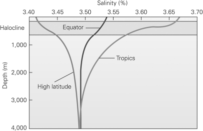
A)There is a higher evaporation rate and a lower rate of precipitation in the tropics.
B)There is a lower evaporation rate and a higher rate of precipitation in the tropics.
C)There are more continents in the tropics and thus more sediment weathered.
D)There is a large influx of freshwater from rivers along the equator.
Question
Question
Question
Question
Question
Question
Question
Question
You are running a sonar survey to map the bathymetry of an ocean basin.Using the following continuous sonar data giving the depth of the seafloor,what feature have you just discovered? 
A)an abyssal plain
B)a deep trench
C)a mid-ocean ridge
D)a continental shelf
A)an abyssal plain
B)a deep trench
C)a mid-ocean ridge
D)a continental shelf
Question
Question
Using the figure below,which of the following lists correctly identifies the various seafloor landforms? 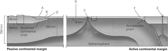
A)A = continental shelf,B = continental slope,D = continental rise,G = abyssal plain, C = mid-ocean ridge,F = trench,and E = volcanic arc
B)B = continental shelf,A = continental slope,C = continental rise,G = abyssal plain, D = mid-ocean ridge,F = trench,and E = volcanic arc
C)G = continental shelf,E = continental slope,F = continental rise,C = abyssal plain, B = mid-ocean ridge,A = trench,and D = volcanic arc
D)A = continental shelf,B = continental slope,D = continental rise,G = abyssal plain, E = mid-ocean ridge,F = trench,and C = volcanic arc
Question
Question
Question
Question
Question
Question
Question
In the figure below,which letters represent the wave height and wavelength? 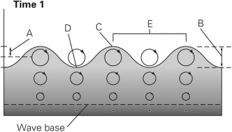
A)E and B
B)E and D
C)C and D
D)C and B
A)E and B
B)E and D
C)C and D
D)C and B
Question
Question
Question
What will eventually happen to the headlands in the figure below? 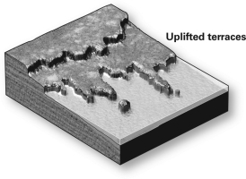
A)They will join as the bays in between fill with sediment.
B)They will become a straight line of cliffs as rock is eroded away.
C)They will remain as they are for millions of years.
D)The sea will submerge them as the terrace is uplifted.
A)They will join as the bays in between fill with sediment.
B)They will become a straight line of cliffs as rock is eroded away.
C)They will remain as they are for millions of years.
D)The sea will submerge them as the terrace is uplifted.
Question
Which of the following figures shows a coast experiencing high tide? 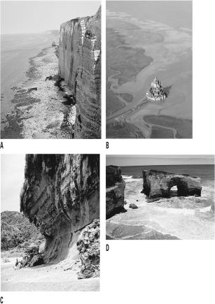
A)A
B)B
C)C
D)D
A)A
B)B
C)C
D)D
Question
Question
Question
In the figure below,which direction is the longshore drift? 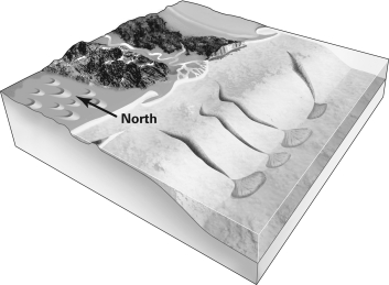
A)south
B)east
C)west
D)It is not possible to tell.
A)south
B)east
C)west
D)It is not possible to tell.
Question
Question
In the figure below,which letters represent the crest and trough? 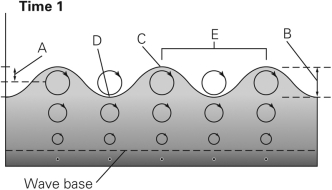
A)A and B
B)E and D
C)C and D
D)C and B
A)A and B
B)E and D
C)C and D
D)C and B
Question
Question
Question
Question
Question
Question
Question
Question
In the figure below,which way is the wave moving? 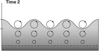
A)to the right
B)to the left
C)back and forth
D)The wave is stationary.
A)to the right
B)to the left
C)back and forth
D)The wave is stationary.
Question
Question
Question
Question
Question
Question
Question
Question
Question
Question

Unlock Deck
Sign up to unlock the cards in this deck!
Unlock Deck
Unlock Deck
1/50
Play
Full screen (f)
Deck 18: Restless Realm: Oceans and Coasts
1
The density of seawater increases with ________ temperature and ________ salinity.
A)increasing;increasing
B)decreasing;increasing
C)increasing;decreasing
D)decreasing;decreasing
A)increasing;increasing
B)decreasing;increasing
C)increasing;decreasing
D)decreasing;decreasing
B
2
The deepest segments of the ocean floor are found ________.
A)along mid-ocean ridges
B)in the geographic centers of abyssal plains
C)in trenches associated with passive margins
D)in trenches associated with subduction zones
A)along mid-ocean ridges
B)in the geographic centers of abyssal plains
C)in trenches associated with passive margins
D)in trenches associated with subduction zones
D
3
Major oceanic surface currents travel ________.
A)parallel to the prevailing wind direction in a region
B)in direct opposition to prevailing winds as a result of the Coriolis effect
C)at an angle to prevailing winds as a result of the Coriolis effect
D)at an angle to prevailing winds as a result of the Doppler effect
A)parallel to the prevailing wind direction in a region
B)in direct opposition to prevailing winds as a result of the Coriolis effect
C)at an angle to prevailing winds as a result of the Coriolis effect
D)at an angle to prevailing winds as a result of the Doppler effect
C
4
Compared with the continental crust,the oceanic crust is ________.
A)denser
B)less dense
C)about the same density
D)about half as dense
A)denser
B)less dense
C)about the same density
D)about half as dense
Unlock Deck
Unlock for access to all 50 flashcards in this deck.
Unlock Deck
k this deck
5
Which of the following would be an area of the ocean with the least dense water?
A)the mouth of the Amazon River
B)off the coast of Greenland
C)the middle of the Pacific Ocean
D)off the coast of Madagascar
A)the mouth of the Amazon River
B)off the coast of Greenland
C)the middle of the Pacific Ocean
D)off the coast of Madagascar
Unlock Deck
Unlock for access to all 50 flashcards in this deck.
Unlock Deck
k this deck
6
Why is the surface salinity in the tropics so much higher than that of the equator or high latitudes?
A)There is a higher evaporation rate and a lower rate of precipitation in the tropics.
B)There is a lower evaporation rate and a higher rate of precipitation in the tropics.
C)There are more continents in the tropics and thus more sediment weathered.
D)There is a large influx of freshwater from rivers along the equator.
Unlock Deck
Unlock for access to all 50 flashcards in this deck.
Unlock Deck
k this deck
7
Approximately what percentage of Earth's surface is covered with water?
A)30%
B)50%
C)70%
D)85%
A)30%
B)50%
C)70%
D)85%
Unlock Deck
Unlock for access to all 50 flashcards in this deck.
Unlock Deck
k this deck
8
Thermohaline circulation carries ________ water from the poles to the equator,where the water becomes ________.
A)warm;cold
B)cold;warm
C)low density;more dense
D)low density;more salty
A)warm;cold
B)cold;warm
C)low density;more dense
D)low density;more salty
Unlock Deck
Unlock for access to all 50 flashcards in this deck.
Unlock Deck
k this deck
9
The sea surface salinity is ________ at the mouth of the Amazon River and ________ in the Dead Sea.
A)low;low
B)high;low
C)low;high
D)high;high
A)low;low
B)high;low
C)low;high
D)high;high
Unlock Deck
Unlock for access to all 50 flashcards in this deck.
Unlock Deck
k this deck
10
The shallowest portions of an ocean found along the margins of continents are the ________.
A)abyssal plains
B)continental rises
C)continental shelves
D)continental slopes
A)abyssal plains
B)continental rises
C)continental shelves
D)continental slopes
Unlock Deck
Unlock for access to all 50 flashcards in this deck.
Unlock Deck
k this deck
11
The form and topography (depth profile)of the ocean floor is termed ________.
A)orogeny
B)bathymetry
C)allocthony
D)aquitopography
A)orogeny
B)bathymetry
C)allocthony
D)aquitopography
Unlock Deck
Unlock for access to all 50 flashcards in this deck.
Unlock Deck
k this deck
12
You have been given the extraordinary opportunity to take Alvin (a submersible)down into the Atlantic Ocean to examine how the seafloor sediments have changed throughout geologic history.You can use Alvin in only one location,however.Where do you pick to visit to get the most out of your trip inside Alvin?
A)down along the Mid-Atlantic Ridge
B)any spot in the abyssal plain
C)just off the coast of Iceland
D)just off the coast of North America
A)down along the Mid-Atlantic Ridge
B)any spot in the abyssal plain
C)just off the coast of Iceland
D)just off the coast of North America
Unlock Deck
Unlock for access to all 50 flashcards in this deck.
Unlock Deck
k this deck
13
Mid-ocean ridges (MORs),which are the sites of new oceanic crust formation,are linear mountain chains that run along divergent plate boundaries.Why does an MOR sit up higher than the surrounding oceanic crust?
A)Hot materials are less dense and shrink,thus the new crust will sit higher than the surrounding crust.
B)As the hot magma exits the MOR,it shoots up higher than the surrounding crust.
C)Hot materials are less dense and expand,thus the new crust will sit higher than the surrounding crust.
D)Hot,geothermal waters cause the new crust to expand and sit higher than the surrounding crust.
Unlock Deck
Unlock for access to all 50 flashcards in this deck.
Unlock Deck
k this deck
14
You are running a sonar survey to map the bathymetry of an ocean basin.Using the following continuous sonar data giving the depth of the seafloor,what feature have you just discovered?
A)an abyssal plain
B)a deep trench
C)a mid-ocean ridge
D)a continental shelf
A)an abyssal plain
B)a deep trench
C)a mid-ocean ridge
D)a continental shelf
Unlock Deck
Unlock for access to all 50 flashcards in this deck.
Unlock Deck
k this deck
15
Compared with the continental lithosphere,the oceanic lithosphere is ________.
A)thicker
B)thinner
C)approximately the same thickness
D)exactly five times thinner
A)thicker
B)thinner
C)approximately the same thickness
D)exactly five times thinner
Unlock Deck
Unlock for access to all 50 flashcards in this deck.
Unlock Deck
k this deck
16
Using the figure below,which of the following lists correctly identifies the various seafloor landforms?
A)A = continental shelf,B = continental slope,D = continental rise,G = abyssal plain, C = mid-ocean ridge,F = trench,and E = volcanic arc
B)B = continental shelf,A = continental slope,C = continental rise,G = abyssal plain, D = mid-ocean ridge,F = trench,and E = volcanic arc
C)G = continental shelf,E = continental slope,F = continental rise,C = abyssal plain, B = mid-ocean ridge,A = trench,and D = volcanic arc
D)A = continental shelf,B = continental slope,D = continental rise,G = abyssal plain, E = mid-ocean ridge,F = trench,and C = volcanic arc
Unlock Deck
Unlock for access to all 50 flashcards in this deck.
Unlock Deck
k this deck
17
At the equatorial ocean basins,the sea surface temperatures may reach 25°C or greater.What is the range of temperatures for the seafloor,approximately 4-5 km below?
A)slightly warmer (33°C)
B)about room temperature (25°C)
C)cool (10°C-15°C)
D)near freezing (1°C-2°C)
A)slightly warmer (33°C)
B)about room temperature (25°C)
C)cool (10°C-15°C)
D)near freezing (1°C-2°C)
Unlock Deck
Unlock for access to all 50 flashcards in this deck.
Unlock Deck
k this deck
18
Which portion of the seafloor is most steeply sloped?
A)abyssal plains
B)continental shelves
C)continental slopes
D)continental rises
A)abyssal plains
B)continental shelves
C)continental slopes
D)continental rises
Unlock Deck
Unlock for access to all 50 flashcards in this deck.
Unlock Deck
k this deck
19
Saline ocean water is ________ dense than fresh water and provides ________ buoyancy to objects floating in it.
A)less;more
B)less;less
C)more;more
D)more;less
A)less;more
B)less;less
C)more;more
D)more;less
Unlock Deck
Unlock for access to all 50 flashcards in this deck.
Unlock Deck
k this deck
20
What is the percentage of dissolved salt in seawater?
A)1.5%
B)3.5%
C)5.5%
D)6.5%
A)1.5%
B)3.5%
C)5.5%
D)6.5%
Unlock Deck
Unlock for access to all 50 flashcards in this deck.
Unlock Deck
k this deck
21
Bioturbation is the ________.
A)generation of turbidity currents by sea creatures
B)mixing of sediment by plankton
C)mixing of sediment by burrowing organisms
D)formation of biochemical sedimentary rocks
A)generation of turbidity currents by sea creatures
B)mixing of sediment by plankton
C)mixing of sediment by burrowing organisms
D)formation of biochemical sedimentary rocks
Unlock Deck
Unlock for access to all 50 flashcards in this deck.
Unlock Deck
k this deck
22
How would the Coriolis affect the space station?
A)The space station would curve to the right because it is above the northern hemisphere.
B)The space station would curve to the left because it is above the southern hemisphere.
C)The space station would not curve because it is above the equator and not affected.
D)The space station would not be affected because it is not in Earth's atmosphere.
Unlock Deck
Unlock for access to all 50 flashcards in this deck.
Unlock Deck
k this deck
23
In the figure below,which letters represent the wave height and wavelength?
A)E and B
B)E and D
C)C and D
D)C and B
A)E and B
B)E and D
C)C and D
D)C and B
Unlock Deck
Unlock for access to all 50 flashcards in this deck.
Unlock Deck
k this deck
24
Longshore currents ________ the shoreline.
A)flow directly towards
B)flow directly away from
C)flow parallel to
D)are not affected by
A)flow directly towards
B)flow directly away from
C)flow parallel to
D)are not affected by
Unlock Deck
Unlock for access to all 50 flashcards in this deck.
Unlock Deck
k this deck
25
Barrier islands are constantly moving in the direction of ________.
A)the longshore drift
B)the high tide
C)downwelling
D)the Coriolis effect
A)the longshore drift
B)the high tide
C)downwelling
D)the Coriolis effect
Unlock Deck
Unlock for access to all 50 flashcards in this deck.
Unlock Deck
k this deck
26
What will eventually happen to the headlands in the figure below?
A)They will join as the bays in between fill with sediment.
B)They will become a straight line of cliffs as rock is eroded away.
C)They will remain as they are for millions of years.
D)The sea will submerge them as the terrace is uplifted.
A)They will join as the bays in between fill with sediment.
B)They will become a straight line of cliffs as rock is eroded away.
C)They will remain as they are for millions of years.
D)The sea will submerge them as the terrace is uplifted.
Unlock Deck
Unlock for access to all 50 flashcards in this deck.
Unlock Deck
k this deck
27
Which of the following figures shows a coast experiencing high tide?
A)A
B)B
C)C
D)D
A)A
B)B
C)C
D)D
Unlock Deck
Unlock for access to all 50 flashcards in this deck.
Unlock Deck
k this deck
28
If the wind is blowing parallel to a coast,will it create an upwelling current or downwelling current?
A)It will create an upwelling current.
B)It will create a downwelling current.
C)Neither;it will enhance the longshore current.
D)Neither;it will create a rip current.
A)It will create an upwelling current.
B)It will create a downwelling current.
C)Neither;it will enhance the longshore current.
D)Neither;it will create a rip current.
Unlock Deck
Unlock for access to all 50 flashcards in this deck.
Unlock Deck
k this deck
29
A wave will disturb the water to a depth equal to ________.
A)its wavelength
B)its surface amplitude
C)the bottom of the seafloor
D)one-half of its wavelength
A)its wavelength
B)its surface amplitude
C)the bottom of the seafloor
D)one-half of its wavelength
Unlock Deck
Unlock for access to all 50 flashcards in this deck.
Unlock Deck
k this deck
30
In the figure below,which direction is the longshore drift?
A)south
B)east
C)west
D)It is not possible to tell.
A)south
B)east
C)west
D)It is not possible to tell.
Unlock Deck
Unlock for access to all 50 flashcards in this deck.
Unlock Deck
k this deck
31
Rip currents ________ the shoreline.
A)flow directly towards
B)flow directly away from
C)flow parallel to
D)are not affected by
A)flow directly towards
B)flow directly away from
C)flow parallel to
D)are not affected by
Unlock Deck
Unlock for access to all 50 flashcards in this deck.
Unlock Deck
k this deck
32
In the figure below,which letters represent the crest and trough?
A)A and B
B)E and D
C)C and D
D)C and B
A)A and B
B)E and D
C)C and D
D)C and B
Unlock Deck
Unlock for access to all 50 flashcards in this deck.
Unlock Deck
k this deck
33
When the sea level rises,an ocean may invade a river valley,producing a nearshore body of water of mixed and variable salinity termed a(n)________.
A)atoll
B)lagoon
C)estuary
D)jetty
A)atoll
B)lagoon
C)estuary
D)jetty
Unlock Deck
Unlock for access to all 50 flashcards in this deck.
Unlock Deck
k this deck
34
Scientists believe that approximately 60 million years ago the closing of the Isthmus of Panama changed the climate of Earth so severely that winters in Europe became 10°C warmer than they had been.Why did this happen?
A)Cold Caribbean Sea waters were forced up into the north Atlantic Ocean.
B)Warm Caribbean Sea waters were forced up into the north Atlantic Ocean.
C)The ice in the Caribbean Sea was broken apart by plate movements.
D)A mountain range formed that blocked the movement of cold air into the area.
A)Cold Caribbean Sea waters were forced up into the north Atlantic Ocean.
B)Warm Caribbean Sea waters were forced up into the north Atlantic Ocean.
C)The ice in the Caribbean Sea was broken apart by plate movements.
D)A mountain range formed that blocked the movement of cold air into the area.
Unlock Deck
Unlock for access to all 50 flashcards in this deck.
Unlock Deck
k this deck
35
If a beach is in an east-west orientation and the waves are approaching the shore from a southeasterly direction,in which direction will the longshore drift be?
A)northern
B)western
C)southern
D)eastern
A)northern
B)western
C)southern
D)eastern
Unlock Deck
Unlock for access to all 50 flashcards in this deck.
Unlock Deck
k this deck
36
The castle on the island of Mont Saint-Michel,France,can be accessed ________ a day during ________ tide,but ________ during neap tide.
A)twice;high;all day
B)once;low;all day
C)twice;low;never
D)once;high;never
A)twice;high;all day
B)once;low;all day
C)twice;low;never
D)once;high;never
Unlock Deck
Unlock for access to all 50 flashcards in this deck.
Unlock Deck
k this deck
37
High tide will be ________ during a full moon than normally.
A)the same
B)lower
C)higher
D)reversed
A)the same
B)lower
C)higher
D)reversed
Unlock Deck
Unlock for access to all 50 flashcards in this deck.
Unlock Deck
k this deck
38
Why is a spring tide so much higher than a normal high tide?
A)because the Sun is aligned with the moon
B)because the moon is aligned with Earth
C)because the moon is directly over the north pole
D)because the Sun is directly over the north pole
A)because the Sun is aligned with the moon
B)because the moon is aligned with Earth
C)because the moon is directly over the north pole
D)because the Sun is directly over the north pole
Unlock Deck
Unlock for access to all 50 flashcards in this deck.
Unlock Deck
k this deck
39
Waves ________.
A)refract so as to impact the shore in a nearly parallel manner
B)refract so as to impact the shore nearly perpendicular to the shoreline
C)reflect directly backward from the angle at which they approach the shoreline
D)are reflected off the shoreline but never refract
A)refract so as to impact the shore in a nearly parallel manner
B)refract so as to impact the shore nearly perpendicular to the shoreline
C)reflect directly backward from the angle at which they approach the shoreline
D)are reflected off the shoreline but never refract
Unlock Deck
Unlock for access to all 50 flashcards in this deck.
Unlock Deck
k this deck
40
In the figure below,which way is the wave moving?
A)to the right
B)to the left
C)back and forth
D)The wave is stationary.
A)to the right
B)to the left
C)back and forth
D)The wave is stationary.
Unlock Deck
Unlock for access to all 50 flashcards in this deck.
Unlock Deck
k this deck
41
If sea level continues to rise and covers the city of Miami,the Florida coast will become a(n)________.
A)emergent coast
B)submergent coast
C)continental slope
D)abyssal plain
A)emergent coast
B)submergent coast
C)continental slope
D)abyssal plain
Unlock Deck
Unlock for access to all 50 flashcards in this deck.
Unlock Deck
k this deck
42
If a dam is installed across a river,what effect will this have on the coastline?
A)It will not allow any fish to swim down the river and into the ocean.
B)It will stop the flow of water,which will lower sea level.
C)It will change the chemistry of the water and pollute the estuary.
D)It will starve the coast of sediment,and the beaches will disappear.
A)It will not allow any fish to swim down the river and into the ocean.
B)It will stop the flow of water,which will lower sea level.
C)It will change the chemistry of the water and pollute the estuary.
D)It will starve the coast of sediment,and the beaches will disappear.
Unlock Deck
Unlock for access to all 50 flashcards in this deck.
Unlock Deck
k this deck
43
Which type of coastline would most likely contain estuaries or fjords?
A)a subductive coastline
B)an emergent coastline
C)a submergent coastline
D)a divergent coastline
A)a subductive coastline
B)an emergent coastline
C)a submergent coastline
D)a divergent coastline
Unlock Deck
Unlock for access to all 50 flashcards in this deck.
Unlock Deck
k this deck
44
Because of wave refraction,erosion along an irregular coastline is ________.
A)even along the length of the coast
B)greatest along headlands
C)greatest in bays
D)the same as it would be along a regular coastline
A)even along the length of the coast
B)greatest along headlands
C)greatest in bays
D)the same as it would be along a regular coastline
Unlock Deck
Unlock for access to all 50 flashcards in this deck.
Unlock Deck
k this deck
45
The entire state of Florida is composed of fossiliferous limestone,what does this imply about Florida during the recent past?
A)It was covered with caves.
B)It was a submergent coast.
C)It was an emergent coast.
D)It was in the mountains.
A)It was covered with caves.
B)It was a submergent coast.
C)It was an emergent coast.
D)It was in the mountains.
Unlock Deck
Unlock for access to all 50 flashcards in this deck.
Unlock Deck
k this deck
46
You are a coastal geologist trying to help a coastal community restore its sediment-starved beach.You decide that beach nourishment is the best option,so you order that dredge sediment from the nearest river be placed on the beach.The sediment is 70% silt and 30% sand.What will be the effect of using this sediment?
A)The silt will be washed away by the waves,leaving the beach no better off.
B)The sand will be washed away by the waves,but the silt will fix the problem.
C)All the sediment will remain on the beach and will fix the problem.
D)All the sediment will remain on the beach,but it will become muddy and filthy.
Unlock Deck
Unlock for access to all 50 flashcards in this deck.
Unlock Deck
k this deck
47
The U-shaped valleys in Kenai Fjords National Park in Alaska were created during a(n)________.
A)transgression
B)regression
C)flooding event
D)undersea landslide
A)transgression
B)regression
C)flooding event
D)undersea landslide
Unlock Deck
Unlock for access to all 50 flashcards in this deck.
Unlock Deck
k this deck
48
You have just bought your dream home along a coastline,but you notice that the beach in front of your new house is slowly disappearing.You decide to solve this by building a groin.Winds blow predominantly from east to west,so where do you place your groin?
A)parallel to the shoreline several meters offshore
B)perpendicular to the shore to the east of your house
C)perpendicular to the shore to the west of your house
D)perpendicular to the shore directly in front of your house
A)parallel to the shoreline several meters offshore
B)perpendicular to the shore to the east of your house
C)perpendicular to the shore to the west of your house
D)perpendicular to the shore directly in front of your house
Unlock Deck
Unlock for access to all 50 flashcards in this deck.
Unlock Deck
k this deck
49
Along beaches,groins have ________.
A)solved the problem of beach drift
B)increased erosion rates immediately up current from the groin
C)increased erosion rates immediately down current from the groin
D)increased depositional rates immediately down current from the groin
A)solved the problem of beach drift
B)increased erosion rates immediately up current from the groin
C)increased erosion rates immediately down current from the groin
D)increased depositional rates immediately down current from the groin
Unlock Deck
Unlock for access to all 50 flashcards in this deck.
Unlock Deck
k this deck
50
Sea level is currently rising at 3.3 mm/yr,and scientists predict that global warming could cause a rise in sea level of 7 m if left unabated.How long will it take the sea to rise 7 m at the current rate?
A)2,121 years
B)0.0004 year
C)2.121 years
D)0.47 year
A)2,121 years
B)0.0004 year
C)2.121 years
D)0.47 year
Unlock Deck
Unlock for access to all 50 flashcards in this deck.
Unlock Deck
k this deck
Unlock Deck
Unlock for access to all 50 flashcards in this deck.


