Map: The Compromise of 1850
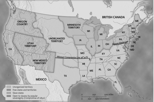
-Which of the following was a significant cause of the political boundaries depicted in the map?
A) The outbreak of the Civil War led to the drawing of new boundaries.
B) Congress became involved in disputes to encourage settlers to move west.
C) The Mexican Cession led to heated controversies over whether to allow slavery there.
D) The Supreme Court intervened in boundary disputes in order to settle them.
Correct Answer:
Verified
Q2: A Pioneer Woman's Westward Journey (1849)
Catherine Haun
Our
Q3: South Carolina’s Ordinance of Secession (1860)
We affirm
Q4: In 1821, the opening of the Santa
Q5: South Carolina's Ordinance of Secession (1860)
We affirm

Unlock this Answer For Free Now!
View this answer and more for free by performing one of the following actions

Scan the QR code to install the App and get 2 free unlocks

Unlock quizzes for free by uploading documents