What does the DARK BLUE are on the map illustrate? 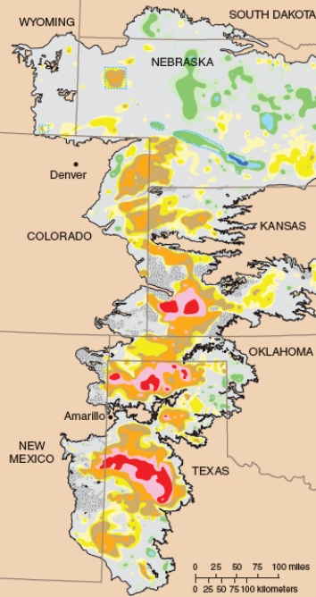
A) Areas of the High Plains Aquifer that contain the deepest water.
B) Areas of the High Plains Aquifer that have had most of the water removed.
C) Areas of the High Plains Aquifer that have run dry.
D) Areas of the High Plains Aquifer with high saltwater intrusion.
Correct Answer:
Verified
Q16: The area of land drained by a
Q17: _ are underground reservoirs in which groundwater
Q18: What percentage of global water is available
Q19: An area of land that is drained
Q20: The area bordering a river channel that
Q22: The 1922 Colorado River Compact regulates the
Q23: Removing too much fresh water from a
Q24: What causes salinization?
A)Overuse of road salts in
Q25: The region with highest demand for additional
Q26: All of the following are problems associated
Unlock this Answer For Free Now!
View this answer and more for free by performing one of the following actions

Scan the QR code to install the App and get 2 free unlocks

Unlock quizzes for free by uploading documents