You are asked to develop a vector-based index model. The model computes the index value using elevation and slope:
Index value = 2 * elevation + slope
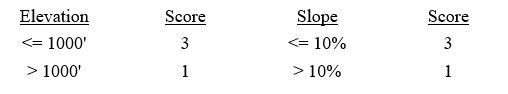
The scoring (data standardization) systems for elevation and slope are as follows:
 You already have the elevation and slope layers. Describe the procedure you will follow to complete the task.
Correct Answer:
Verified
Q10: Explain the difference between "crisp threshold values"
Q11: Many index models use the weighted linear
Q12: The Land Evaluation and Site Assessment (LESA)
Q13: Suppose a county government asks you to
Q14: To build an index model, one must
Q16: What does a spatially explicit model mean?
Q17: The output of a site analysis is
Q18: Geographically weighted regression builds a regression model
Q19: The output of an index model is
Q20: How does a static model differ from
Unlock this Answer For Free Now!
View this answer and more for free by performing one of the following actions

Scan the QR code to install the App and get 2 free unlocks

Unlock quizzes for free by uploading documents