The four schematic cross sections below show the potential groundwater resources for an area of hills and valleys. Assume the region is underlain by an open aquifer composed of sand and gravel and receives plentiful rainfall. Which diagram is the best representation of the relationship between topography and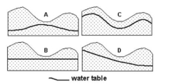 water table?
A) Diagram A
B) Diagram B
C) Diagram C
D) Diagram D
Correct Answer:
Verified
Q2: Which condition may result in surface subsidence?
A)
Q3: The photograph shown below is that of
Q4: The photograph shown below is that of
Q5: A groundwater well is pumped for a
Q6: The cross section below simplifies the groundwater
Q8: A farmer drilled a well into an
Q9: Read the following passage taken from http://www.nwrc.usgs.gov/about/5-year-plan.htm.
Think
Q10: Read the following passage taken from http://www.nwrc.usgs.gov/about/5-year-plan.htm.
Think
Q11: Read the following passage taken from http://www.nwrc.usgs.gov/about/5-year-plan.htm.
Think
Q12: Read the following passage taken from http://www.nwrc.usgs.gov/about/5-year-plan.htm.
Think
Unlock this Answer For Free Now!
View this answer and more for free by performing one of the following actions

Scan the QR code to install the App and get 2 free unlocks

Unlock quizzes for free by uploading documents