Questions refer to the map and image below.
Commercial Hubs in Mesoamerica and North America c. 1000 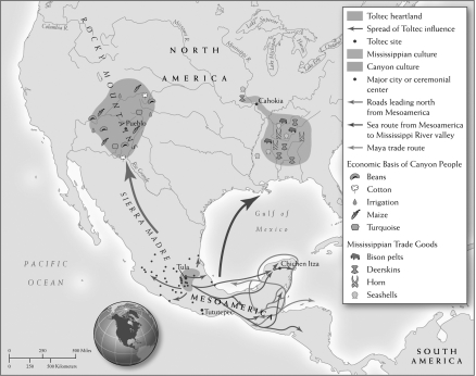 Monks Mound, Cahokia Mounds State Historic Site
-Based on the map, which of the following accurately describes the trade route from Mesoamerica to the Canyon people?
A) A sea route across the Gulf of Mexico
B) A land route through the Sierra Madre Mountains
C) A land route to Chichen Itza
D) A sea route along the western coast of Mesoamerica
Correct Answer:
Verified
Q5: Which of the following contributed to the
Q11: Questions refer to the map and image
Q12: Questions refer to the passage below.
Silks were
Q13: Questions refer to the following passage.
For these
Q14: Questions refer to the map and image
Q15: Questions refer to the images below.
Image 1:
Q16: Which of the following is a reason
Q17: Questions refer to the passage below.
Silks were
Q18: Questions refer to the following passage.
For these
Q19: Questions refer to the images below.
Image 1:
Unlock this Answer For Free Now!
View this answer and more for free by performing one of the following actions

Scan the QR code to install the App and get 2 free unlocks

Unlock quizzes for free by uploading documents