Use the images below and your knowledge of world history to answer all parts of the question that follows.
James Cheshire of Spatial Analysis has visualized British, Dutch, and Spanish historical shipping records to produce maps of eighteenth-century shipping trade routes. 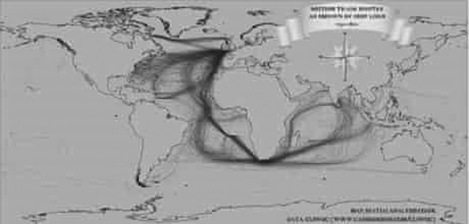 Global Shipping Traffic 2012
 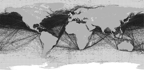 (A) Identify and explain ONE continuity between patterns of trade in the two maps.
(B) Identify and explain ONE change between patterns of trade in the two maps.
(C) Explain ONE limitation in using the two maps to explain continuities and changes in global trade patterns over the past 300 years.
Correct Answer:
Verified
View Answer
Unlock this answer now
Get Access to more Verified Answers free of charge
Q62: Define the concept of cultural modernism in
Q98: Questions refer to the table below.
World War
Q100: Questions are based on the following image.
Indian
Q101: Evaluate the extent to which science
Q102: Develop an argument that evaluates the
Q103: Use the passage below and your knowledge
Q104: Answer all parts of the question that
Q105: As societies develop, they affect and
Q106: Questions refer to the photo and graph
Q107: The settlements that ended World War
Unlock this Answer For Free Now!
View this answer and more for free by performing one of the following actions

Scan the QR code to install the App and get 2 free unlocks

Unlock quizzes for free by uploading documents